
Abandoned & Little-Known Airfields:
Southeast Kansas
© 2002, © 2024 by Paul Freeman. Revised 9/7/24.
This site covers airfields in all 50 states: Click here for the site's main menu.
____________________________________________________
Please consider a financial contribution to support the continued growth & operation of this site.
Coffeyville Municipal Airport (original location) (revised 2/8/21) - Coffeyville Aux AAF #3 / Independence Aux AAF #3 / Edna Municipal (revised 2/8/21)
Conard Field / Intermediate Field Site 42B (revised 2/1/21) - Dempsay Farm Airport (revised 9/7/24) - Gilmore Airport (revised 9/8/22)
Glenwood Airport (revised 1/15/24) - State Line Airpark (revised 1/15/24)
____________________________________________________
Dempsay Farm Airport, Rantoul, KS
38.542, -95.104 (Southwest of Kansas City, MO)
Dempsay Farm Airport was simply depicted as “Landing Strip” on the 1983 USGS topo map.
This airfield was evidently established at some point between 1964-81,
as it was not yet depicted on a 1959 aerial photo or the 1964 USGS topo map.
The earliest depiction which has been located of this airfield was a 1981 aerial photo.
It depicted 3 grass runways, with at least 4 aircraft parked near some buildings on the east side.
The 1983 USGS topo map depicted a single unpaved northeast/southwest runway, labeled simply as “Landing Strip”.
According to their website, Dodson International Parts, Inc. was founded in 1984.
Located immediately across the road from this airfield, Dodson eventually grew to be a major aircraft parts recycling/sales firm, which has dismantled over 3,000 aircraft.
Dennis Boykin recalled, “Dempsay Farm Airport is the home of Dodson International.
Originally founded in Ottawa, KS, Dodson outgrew that space & bought the farm in Rantoul to expand.
Rantoul's not listed on any Sectionals so as to not attract traffic. The runways almost never are used for takeoff - airplanes go there to become parts for other planes.”

The earliest photo which has been located of the Dempsay Farm Airport was a 1991 USGS aerial view looking south.
The airfield consisted of 3 grass runways, the longest being the 3,000' northeast/southwest strip.
Three aircraft were visible on the northeast side of the airfield, including one large 4-engine transport (model unknown).
No airfield at this location was depicted on the 1993 Kansas City Sectional Chart.

A 2016 aerial view looking south at the Dempsay Farm Airport showed the runway configuration remained the same.
The number of large 2-engine & 4-engine transports parked on the airfield had increased to 5,
and hundreds of aircraft fuselages were visible across the street to the east.
A Lockheed JetStar was visible mounted on a pole across the street from the airfield.

A 2018 or before photo of a Lockheed JetStar mounted on a pole across the street from Dempsay Farm Airport.
As of 2018, no airfield at this location was depicted on aeronautical charts, or registered with the FAA.
Will Hazen reported in 2018, “The field's official name was Dempsay Farm Airport.
The aircraft stored on site include 3 former Central Air Services & USAF C-54/DC-4s (N816D 1944 C-54E, N67061 1945 C-54, and N96454 1942 C-54D-DC).
All their registration certificates were canceled in early 2018.
Also on site is a Lockheed Lodestar built in 1940 with wings and engines off, which is visible in the aerial view, N555H, whose registration certificate just recently expired (latter part of June).
Closest to the road lies a DC-3 N37737, built in 1944, with a certificate canceled in 2009.
This aircraft flew for roughly 10 years with British European Airways.
The aircraft next to the DC-3 is an ex-USAF Convair C-131B, N43941, which still holds its valid registration until 8/31/18.
The field used to house at least 2 yellow crop dusters, but I didn't see them on my last trip out earlier this month.”

A 2024 photo looking northwest at the DC-3 & variety of other aircraft at Dempsay Farm Airport.
Thanks to Lee Corbin for pointing out this airfield.
____________________________________________________
Conard Field / Intermediate Field Site 42B, Ottawa, KS
38.664, -95.243 (Southwest of Kansas City, MO)

A 1911 landing at Conard Field of an unidentified biplane on a Trans-Continental trip (courtesy of the Franklin County Historical Society, via Will Hazen).
According to the Franklin County Historical Society (courtesy of Will Hazen),
“This farm of 1,000 acres was purchased in 1869 by the Conard brothers.
Conard Air Field was established by John, and is known as one of the oldest landing strips in Kansas.
The first transcontinental plane trip in 1911 stopped at the field.
In 1922 Conard Field was officially designated by the US Department of Commerce as one of 50 national emergency landing fields in the US for airmail carriers (it was designated #50).
When that happened the federal government added lighting & a beacon light.
The Conards were hired by the government & were responsible for putting out flares in bad weather & smudge pots on the runway if there would be an emergency landing.
Both John Conard & his wife were weather observers.”
According to the 1932 “Descriptions of Airports & Landing Fields in the United States” (according to Will Hazen),
Conard Field was designated Department of Commerce Intermediate Field Site 42B along the Amarillo - Kansas City Airway.
It consisted of a 63 acre sod property, having 2 runways, with the longest being 2,640'.
On 4/20/32, the Ottawa Herald (courtesy of Will Hazen) said that 2 planes had landed at Conard the night before.
Both were of the NAT division of United Air Lines.
The first was a Chicago to KC flight but KC was fogged in.
The second was a mail flight grounded because of fog.

The earliest aeronautical chart depiction which has been located of Conard Field was on the June 1932 KS City Sectional Chart,
which depicted Conard as Commerce Department Site 42B.
On 4/20/32, the Ottawa Herald (courtesy of Will Hazen) said that the Federal government stopped using Conard in 1933 as an emergency field.
However on 7/2/33 Conard Field was reopened in cooperation with the Ottawa Chamber of Commerce, with Paul Gaynor hired as the manager.
A 7/2/33 postmark had a drawing of an airplane & was marked “7/2/33 / Ottawa, Kansas / Conard Air Port”.
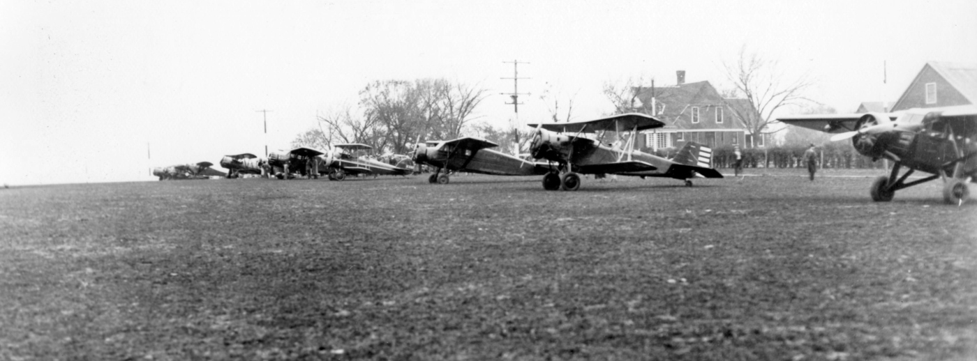
An 11/15/34 photo of a variety of biplanes & monoplanes at Conard Field (courtesy of the Franklin County Historical Society, via Will Hazen).
Conard Field was not yet depicted on the May 1939 KS City Sectional Chart.
During WWII, Conard Field was used for a training program for the military run by Gaynor, with classes taught by Ralph Robertson,
run under auspices of the Civil Aviation Administration War Training Service.
According to Paul Gaynor, the only building there was a “shack next to the rotating beacon that had the numerals 50 emblazoned” on it.
Gaynor then moved in a shed from 8th & Willow in Ottawa to use as a hangar. Then a classroom & office were built.
At the height of the program there were 8 Aeroncas used to train the pilots -parked outside, with the shed/hangar not having enough room.

A 1942 aerial view looking east at Conard Field (courtesy of the Franklin County Historical Society, via Will Hazen),
showing a row of high-wing single-engine light planes parked on a grass airfield south of a single hangar marked “Ottawa”.

A 1942 aerial view looking southeast at Conard Field (courtesy of the Franklin County Historical Society, via Will Hazen).

A circa 1942 photo of Conard Field (courtesy of the Franklin County Historical Society, via Will Hazen).
The city of Ottawa helped finance an addition to the field.
Representatives sent to Gravois Mills, Mo bought an old boat storage building, took it apart & moved it to Conard where it was reassembled.
But just about the time they finished, the government canceled the training program, approximately in the mid-1940s.

A circa mid-1940s photo of Conard Field (courtesy of the Franklin County Historical Society, via Will Hazen). Will Hazen noted, “The big building had been moved in.”
Dan Linn recalled, “During 1943 I was in high school in Lawrence KS.
Having secured a 30 minute unsatisfactory instruction training flight in a Aeronca Defender airplane at the Lawrence Airport where I worked part time, I learned about the north Ottawa field.
Inquires resulted in my learning that I could secure some flight training at Ottawa.
Starting 7/21/43 I secured a free ride on a morning southbound bread truck, which got me near Conard Field just the sun was lighting the eastern sky (that's early dad).
Then I walked about 1/3-1/2 mile to a waiting 65 HP Aeronca 'Bug Eyed' Chief Aeronca.
Following a 30 minute training flight, walked to the highway & hitchhiked back to Lawrence for my first class.
This exercise repeated 7/21, 23, and 24, which included 5 flights of 30 minutes each, the final was a trip back to Lawrence.
My log book was signed by P.H. Gaynor 79854-41, as my instructor. He was the best, as I may relate later.
At that time there was only one Aeronca Chief on the field. There were no runways, as there was only a sod field.
The small building was not of sufficient size for any airplanes. I have no memories of light towers on the field.”
Dan continued, “As you may remember the 1939 'Bug Eyed' Chiefs were such that you sat low, with your eyes just above the bottom of the side window.
Also forward visibility was limited until the tail was raised. About the third 30 minute training flight started with the instructor saying 'You take off yourself today Dan.'
We entered the airplane as it faced south. Yours truly rapidly advanced the throttle to full.
I noticed that we were nearing a small pond, just as I was told calmly 'You should add some right rudder.'
After complying I noticed that there was a bob wire fence off to our left.
Next my attention was drawn to the fact that the grass was going straight back from the front to the rear under the left tire.
This view was rapidly changed with the grass coming from about 45 degree left!
With that occurred a slight skipping to the left along with the controls feeling light more like they had been in flight the day before!
Quick as a wink, I looked forward, neutralized the rudder & commenced a flight to the north!
The barn followed by the house sliding by before the undersigned uttered something like 'Probably should look forward sooner during takeoffs in the future.'”

The March 1944 KS City Sectional Chart (courtesy of Ron Plante) depicted Conard Field as a commercial/municipal airport.
After the war, a new airport was in the process of being built south of town.
Conard was used for training for returning Gis & leased to pilots who ran flying services, gave lessons, etc.

A circa 1940s photo of a gathering in front of a plane at Conard Field (courtesy of the Franklin County Historical Society, via Will Hazen).

Conard Field, as depicted on the 1947 USGS topo map.
In the mid 1950s, Conard Field was used by the National Guard to store its one plane.
According to Clara May Sexton's obituary (courtesy of Will Hazen),
She helped Earl Sexton run Ottawa flying Service at Conard Field Airport & ran a small cafe there, noted for her pies.”
A 1955 aerial photo showed no trace of aviation activity at the site of Conard Field.
The large hangar seen in 1940s photos had evidently been removed.

The last depiction which has been located of Conard Field was on the 1956 USGS topo map.
It depicted “Conard Airport” as T-shaped property outline, with a small building on the north side.
A 5/15/57 Ottawa Herald article said that both Mr. & Mrs. Conard were dead & that the land that had comprised the airfield had been divided between heirs.

The last aeronautical chart depiction which has been located of Conard Field was on the January 1960 Kansas City Sectional Chart,
which depicted Conard as a commercial/municipal airport with a 2,400' unpaved runway.
Conard Field was evidently closed at some point between 1960-69, as it was no longer depicted on the February 1969 Kansas City Sectional Chart.

A 2016 aerial view looking south showed no recognizable trace of Conard Field.
Will Hazen noted in 2017, “The outline of both runways is still visible, and when the US 59 bypass was constructed recently, it cut through the southwest corner of the north/south runway.
I don’t think any of the present buildings could be original buildings.”
The site of Conard Field is located southeast of the intersection of Reno Road & Montana Road.
Thanks to Will Hazen for pointing out this airfield.
____________________________________________________
Glenwood Airport, Overland Park, KS
38.954, -94.674 (Southwest of Kansas City, MO)

Glenwood Airport, as depicted on the September 1948 Kansas City Sectional Chart.
Photo of the airport has not been located.
This small short-lived general aviation airport to the southwest of Kansas City was evidently established at some point between 1947-48,
as it was not yet depicted on the September 1947 Kansas City Sectional Chart.
The earliest aeronautical chart depiction which has been located of Glenwood Airport was on the September 1948 Kansas City Sectional Chart.
It depicted Glenwood Airport as having a mere 1,800' unpaved runway.
The earliest photo which has been located of Glenwood Airport was on a 1948 aerial photo.
It depicted Glenwood Airport as having a rectangular grass airfield, with a small hangar on the north side.
There were no aircraft visible on the field.
Glenwood Airport was not depicted on the 1950 USGS topo map.

The last aeronautical chart depiction which has been located of Glenwood Airport was on the May 1952 Kansas City Sectional Chart.
It depicted Glenwood Airport as having a mere 1,800' unpaved runway.
Glenwood Airport was evidently soon closed (for reasons unknown), at least officially,
as it was no longer depicted on the June 1953 Kansas City Sectional Chart
or the June 1954 Kansas City Local Aeronautical Chart (courtesy of Mac Hayes).
Glenwood Airport may have continued to see some aviation use after its official closure,
as a 1955 aerial view depicted 4 light single-engine aircraft parked around the small hangar on the north side.
The field had a single north/south unpaved runway.

The 1957 USGS topo map depicted “Glenwood Landing Field” as a rectangular property outline with 1 small building on the north side.
A 1959 aerial photo depicted residential streets and houses being built over the Glenwood Airport property.
The hangar had been removed, leaving no trace of the little airport.
One of hundreds of small American general aviation airports lost to suburban housing development.

Glenwood Airport, as depicted on the 1961 USGS topo map.
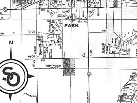
The last depiction which has been located of Glenwood Airport was on a 1962 street map (courtesy of Ken Hammond).
It depicted Glenwood Airport as a rectangular property outline.
The 1963 USGS topo map depicted residential streets covering the Glenwood Airport property.

A 2015 aerial view looking north showed no trace remaining of Glenwood Airport.
The site of Glenwood Airport is located southeast of the intersection of West 95th Avenue & Lowell Road.
Thanks to Ken Hammond for pointing out this airfield.
____________________________________________________
Gilmore Airport (57K), Pleasanton, KS
38.13, -94.75 (South of Kansas City, MO)

Gilmore Airport, as depicted on the February 1965 Kansas City Sectional Chart.
No airfield was yet depicted at this location on a 5/6/57 USGS aerial photo (courtesy of Dallam Oliver-Lee) or the 1958 USGS topo map.
According to its FAA Airport/Facility Directory data, Gilmore Airport was established in 10/1960.
Gilmore Airport was not yet depicted on the December 1960 Kansas City Sectional Chart.
The earliest depiction which has been located of Gilmore Airport was on the February 1965 Kansas City Sectional Chart.
It depicted Gilmore as having a 2,400' unpaved runway.

The earliest photo which has been located of Gilmore Airport was on a 1971 USDA aerial photo (courtesy of Dallam Oliver-Lee).
It depicted the field as having a single northeast/southwest runway.

The 1978 USGS topo map depicted Gilmore Landing Strip as an unpaved northeast/southwest runway.
A 10/2/81 USGS aerial photo (courtesy of Dallam Oliver-Lee) depicted Gilmore Airport as having 2 small buildings at the southwest corner.

A 1992 USGS aerial view looking north at Gilmore Airport.

A 7/20/12 aerial photo (courtesy of Dallam Oliver-Lee) depicted Gilmore Airport as remaining intact,
but with no aircraft visible or any other sign of recent aviation usage.

Gilmore Airport was evidently closed at some point in 2013,
as the May 2013 Kansas City Sectional Chart (courtesy of Dallam Oliver-Lee) labeled the field as “Gilmore (Closed).”
As of 2013, its FAA Airport/Facility Directory data listed Gilmore Airport's owner as “David Gilmore, Trust”,
and its manager as David Lamb, Linn County Clerk.
The field was described as having a single asphalt 2,870' Runway 3/21, with “tall weeds growing in runway pavement cracks”.

A 2014 photo by Ken Lewis looking northeast along the Gilmore Airport runway, showing the closed-runway “X” marking.

A 2014 photo by Ken Lewis of an abandoned Gilmore Airport hangar.

A 2016 aerial view looking north at the remains of Gilmore Airport.
Riss Suttom reported in 2018, “Gilmore... It is right down the road.
It appears the runway even though marked closed has had some maintenance applied as I saw no visible cracks in the surface. The building are quite dilapidated.”
Gilmore Airport is located northeast of the intersection of East 700th Road & Read Road.
Thanks to Dallam Oliver-Lee for pointing out this airfield.
____________________________________________________
State Line Airpark (3KC), Leawood, KS
38.89, -94.609 (West of Kansas City, MO)

An October 1928 photo (courtesy of Noah Dunker) of an unidentified biplane at State Line Airpark.
This general aviation airport was located directly along the Kansas/Missouri border (thus the name),
with the eastern boundary of the airport property being State Line Road.
The date of construction of State Line Airpark is unknown.
The earliest depiction of the field which has been located was the above October 1928 photo of a biplane at the field (courtesy of Noah Dunker).
Noah reported, "My grandparents lived less than 1/4 mile north of the airfield."
He said of his grandmother, "She recalled that there were no buildings & that it was little more than a smoothed-over strip in a field."
State Line was not yet depicted on Kansas City Sectional Charts from June 1932 - March 1946, the 1939 USGS topo map,
or listed among active airfields in the 1945 AAF Airfield Directory (courtesy of Scott Murdock).

The earliest chart depiction of State Line Airpark which has been located was on the September 1946 Kansas City Sectional Chart.
It depicted State Line as a commercial airport.
According to John Shields (referencing obituaries), “Murl Johnston & his brother Alva Leroy Johnston, a TWA pilot, owned the airport from 1946-63.”

The earliest aerial view which has been located of State Line Airpark was a 9/25/48 USGS aerial view.
It depicted State Line as having a single unpaved north/south runway, with 2 rows of hangars on the southeast side,
and a total of 14 single-engine aircraft parked around the trees on the southwest edge.

The 1949 KS Airport Directory (courtesy of Chris Kennedy)
described State Line Airpark as having 4 sod runways, with the longest being the 2,200' north/south strip.
Three buildings (hangars?) were situated on the southeast corner of the field.
The airport was said to offer repairs & fuel, 6 the manager was listed as M. L. Johnston.

The 1949 Kansas City Sectional Chart (courtesy of Chris Kennedy)
described State Line as having a 2,200' unpaved runway.
John Shields recalled, “I learned to fly at State Line in 1951, where I worked as a lineboy,
up through flight instructor, 1951-53, before joining the Naval Aviation Cadet program.
My boss at the time was Murl Johnston”, the joint owner of State Line Airpark.
Charles Haus recalled, “I flew out of State Line & knew Merle & his brother, who flew for TWA.”

The June 1954 Kansas City Local Aeronautical Chart (courtesy of Mac Hayes) depicted State Line Airpark as having a 2,200' unpaved runway.

The 1957 USGS topo map depicted “State Line Landing Field” as having 3 unpaved runways, with several buildings along the south side.

A circa late-1950s – early 1960s photo of the Aeronca in which Katie Reitmayer's grandfather flew his first solo flight,
in front of a hangar marked “State Line Airpark Inc.”

A circa 1960s photo by Jim Bolas of N1541B, a 1955 Luscombe 8A Silvaire at State Line Airpark.

An aerial view looking north at State Line Airpark, from a circa 1957-61 MO Airport Directory (courtesy of Chris Kennedy).
State Line had evidently gained a paved runway at some point between 1949-61,
as the field was depicted as having a 2,200' hard-surface Runway 17/35, along with 2 shorter turf runways.
Several rows of hangars were depicted on the south side of the field,
including some which stood directly under the final approach to the field's primary runway
The field was said to offer fuel, hangars, tiedowns, and major repairs.
The 1962 AOPA Airport Directory described State Line Airpark as having a 2,200' concrete Runway 18/36,
a 2,000' turf & concrete Runway 14/32, and a 2,000' turf Runway 4/22.
The operator was listed as Murl Johnston.
The directory erroneously listed State Line Airpark in its Missouri section.
According to John Shields (referencing obituaries), Murl Johnston & his brother, Alva Leroy Johnston owned State Line Airpark until 1963.
John reported, “All I have heard, from one old pilot, who responded to my ad in the KC Star,
was that some guy named Fisher had the airport after the Johnstons,
but that the operation was 'not well-run'”.
According to Ron Schauble, “State Line Airport had several operators after Johnson, several of short duration.
One of these was Bill Stutesman, who had been operating at Hillside Airport.
Don Fisher took it over in 1965.
He built this into a thriving operation, and he remained until the end.
During Don’s operation the flight school was built up to include large ground school classes & a complete flight training program.
The Johnsons had used primarily Aeronca 7AC Champs as trainers.
At one time there were probably 20 of them.
Many of these succumbed to hard landings by students learning how to land a tailwheel aircraft.
For a while these were stashed around the airport wherever they would be out of the way.
The instrument trainer in 1964 was an 11AC Champ with fight instruments in a separate panel above the instrument panel.
In the fall of 1964 two new Cessna 150s were added.
A new Cessna 172 was added shortly thereafter.
There was an active charter service & aircraft sales operation.
State Line had numerous highly experienced & colorful pilots employed for a number of years.
Ken Fairchild had been a TWA pilot.
He had also flown open cockpit biplane fighters for at least one South American country.”
Ron continued, “I learned to fly there in 1964-65, instructed there in 1967-68,
and continued to fly out of there until its close.
My father kept one of several airplanes in a T-hangar until the end.”

The August 1965 Kansas City Sectional Chart (courtesy of Ron Kunse)
depicted State Line Airpark as having a single 2,200' paved north/south runway.
Ron continued, “Shortly after passenger operations moved [from Fairfax Airport] to MCI,
Don Fisher inaugurated a scheduled commuter service between State Line & International.”

State Line Airpark, as depicted on the July 1973 Kansas City Sectional Chart (courtesy of Chris Kennedy).
Arne Klepinger recalled, “State Line Airport... I was there working & learning to fly there in 1974-75, aged 17.
Don Fisher was running it, including a Part 135 operation from KCI, Richards Gebraur, and State Line Airports.
The operation used a Cherokee 6 & Aero Commander 520.
I was there the day the Commander crash landed on the runway; no one was injured. Fischer did not have a good reputation.
The runway was very narrow, maybe 30', and very poorly lit.
The north end had a tall tree, and the runway was high in the middle so a pilot couldn’t see the other end, which caused some excitement.
Si Royce had an East/West grass strip maybe a mile north of State Line, and was great guy. He regularly flew his Twin Bonanza, Stearman, and Decathlon, into State line.
I have many fond memories of learning to fly there, with Toni C, Ken B, and mechanics Dwayne L, and Chuck.”
Joe Moylan recalled of State Line Airpark, “I soloed here in 1976.”

The 1979 Flight Guide (courtesy of Chris Kennedy) depicted State Line Airpark as having a single 2,200' paved Runway 18/36,
as well as 2 unpaved runways to the west.
According to Senior Airport Planner Brad Weisenburger, "There were a few hangars all at the far southern end.
The ground falls away from the runway end at the south by about 10 feet.
As the story goes, a pilot could land & then taxi straight in to the hangar on the south.
The hangars were not an obstruction because the roof line was below the runway end elevation."
Weisenburger said that FAA records show that the State Line Airpark was closed in 1982.
The 1983 Kansas City Sectional Chart depicted State Line Airpark as an abandoned airfield.
Jim Foulk recalled, “As a child in the mid-1980s I played many soccer games at the airport after it was closed.
We played just west of the main runway & the parents would park
on the runway & taxiway depending on what side you team was on.
The pavement was in really bad shape at the time & is more than likely the reason for it to close.”

A 1991 USGS aerial view looking northwest showed the abandoned State Line Airpark site,
with the runway & taxiway remaining intact though deteriorated. The hangars & buildings at the south end appeared to have been removed.
Arne Klepinger recalled, “The airport sat empty for many years, maybe as late as the early 1990s. Very sad to see it go to more houses & malls.”
Noah Dunker recalled, "My grandparents lived less than 1/4 mile north of the airfield.
In the early- and mid-1990s, long after it had shut down,
my grandfather would take me to the old, blighted runways to launch our model rockets.
The site offered ample acreage to keep our rockets away from traffic & homes."
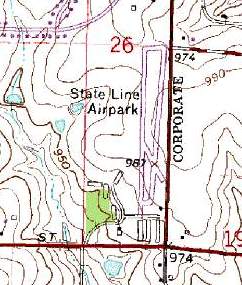
State Line Airpark was still depicted on the 1995 USGS topo map, even though it had been closed by that point for 13 years.
According to Brad Weisenburger, the State line Airpark property remained in row crops until 2002.

A 2003 photo by Brad Weisenburger looking northeast from the former apron area
along the remains of Runway 18/36 at State Line Airpark,.
He reported the property was in the process of being developed.
He observed, “There are not any remaining buildings, only some piles of rocks & concrete."
State Line Airpark was no longer depicted at all (even as an abandoned airfield) on 2003 aeronautical charts.

A 2005 photo by Noah Dunker, looking north along the pavement remains of the runway at the site of State Line Airpark.
Noah reported, “133rd Street was built & cut through the old runway.”

An August 2007 aerial view by Joe Moylan looking northwest at the site of State Line Airpark
shows that a majority of the the pavement of Runway 18/36 remains intact.

A circa 2008 aerial view looking north shows that a majority of the the pavement of State Line's Runway 18/36 remained intact.
The path of Runway 14/32 was also still apparent.

A 2016 aerial view looking northwest showed that a building had covered the northern portion of the State Line Airpark site,
but the middle portion of the paved runway & taxiway remained intact.

A 2022 photo looking northwest at the remains of the State Line Airpark ramp pavement.
Jim Stephens reported in 2025, “The State Line Airport property has been regraded back to mostly the original airport state in preparation for development on the south end of the property.
It was sad seeing it in such a state, as some of my earliest memories of aviation was seeing aircraft in & out of the airport when it was operating.
It had become quite overgrown up to about August 2025 & is now cleared back to dirt but graded in such a state as when the airport was there.
The original road at the south end of the airport was Kansas 150 (Missouri 150) which connected eastern Jackson County with US 69 in Kansas.
For a long time a single grave of a young girl was across [Route] 150 in-line with the north/south runway.”
The site of State Line Airpark is located northwest of the intersection of State Line Road & West 135th Street.
____________________________________________________
(Original) Coffeyville Municipal Airport, Coffeyville, KS
37.06, -95.64 (Southeast of Wichita, KS)

The original Coffeyville Municipal Airport was depicted as a commercial/municipal airport on the August 1934 Tulsa Airway Chart.
The original municipal airport for the town of Coffeyville was located on the northwest side of the town.
According to Chris Decker, “It was constructed as a Works Progress Administration project & dedicated in 1933 as Pfister Park Airport.”
The airport's hangar was also constructed by the WPA in 1933, according to the Coffeyville Aviation Heritage Museum.
The earliest depiction of the original Coffeyville Municipal Airport which has been located was on the August 1934 Tulsa Airway Chart.
It depicted Coffeyville as a municipal/commercial airport.
According to Chris Decker, “It was a hub with a terminal for N.A.T. Safeway & TWA Airlines until 1935.”
According to Cary Finder, “The Coffeyville Airport was designated by the Post Office Department on 8/1/36
for use as of 9/1/36 as a stop point on the airmail route AM-26 between Kansas City & Tulsa OK.”
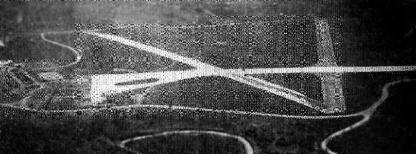
An aerial photo looking north at at the original Coffeyville Municipal Airport from The Airport Directory Company's 1937 Airport Directory (courtesy of Bob Rambo).
It described Coffeyville as a 172 acre sod field, with three 2,800' crushed rock runways.

An undated aerial view looking north at the original Coffeyville Municipal Airport, showing a hangar & several aircraft (courtesy of Chris Decker).

An undated aerial view of looking east at the original Coffeyville Municipal Airport, showing a hangar & 17 single-engine aircraft (courtesy of Chris Decker).
The April 1944 US Army/Navy Directory of Airfields (courtesy of Ken Mercer)
described the Coffeyville Airport as having a 2,700' hard-surface runway.
It indicated that Army flight operations were conducted, along with “intensive training”.
When the former Coffeyville Army Airfield (located to the northeast of Coffeyville) was relinquished by the military for civilian use,
some civilian flight operations relocated there from the
The original Coffeyville Municipal Airport was depicted as “Coffeyville #2” on the 1947 USGS topo map.

The 1948 KS Airport Directory (courtesy of Chris Leonard) depicted the original Coffeyville Municipal Airport as having 3 runways,
with the longest being the 2,660' southeast/northwest crushed rock strip, and having 2 small buildings on the southeast side.
The manager was listed as J.H. Lightstone.
The original Coffeyville Municipal Airport was depicted as “Coffeyville #2” on the 1949 USGS topo map.

The last aeronautical chart depiction which has been located of the original Coffeyville Municipal Airport was on the December 1955 Tulsa Sectional Chart (according to Chris Kennedy).
Note that the former Coffeyville AAF (to the northeast) was also depicted as a civilian airport, named “McGugin”.
The original Coffeyville Municipal Airport was evidently closed at some point between 1955-56,
as it was no longer depicted on the December 1956 Tulsa Sectional Chart.

The last photo which has been located of the original Coffeyville Municipal Airport was a 5/11/58 USGS aerial view.
The field had a total of 3 runways (fairly deteriorated compared to earlier photos), and a few small hangars on the southeast side.
There were no aircraft visible parked outside.
The original Coffeyville Municipal Airport was no longer depicted at all on the 1959 USGS topo map.
The original Coffeyville Municipal Airport (also known as the Big Hill Airport)
was closed in 1960, according to the Coffeyville Aviation Heritage Museum.

The 1991 USGS aerial photo showed that the original Coffeyville Airport's hangar still existed,
although all traces of the paved runways had been removed, with their area having been reused as a park.

A 2005 photo Chris Decker of the hangar which remains from the Coffeyville Municipal Airport.
Chris Decker reported in 2005, “It had three 3,500' runways that were asphalted at some point.
Some residual of the runways can be found in the area,
however, the terrain has changed & it would not be possible to land an aircraft in the area.
Currently, the only thing that remains are several of the support buildings & the large hangar.
The main hangar houses the Coffeyville Aviation Heritage Museum.”
Dedicated to early aviation & pioneer pilots of the area, the Aviation Heritage Museum features memorabilia from the Coffeyville Air Base,
a Funk airplane & Breezy, owned by Joe Funk & donated to the museum, plus many other displays.
The museum is housed the original airport's 1933 hangar.
Kevin Patrick reported, “A [Republic] F-84F which used to be on Route 60 in Peoria AZ was dismantled & moved to Coffeyville KS in 2006.”
Chris Leonard reported, “Emil Roesky of the Aviation Heritage Museum was instrumental in acquiring & getting displayed” Coffeyville's F-84F.

A 3/22/14 photo of a Republic F-84F mounted on a pylon in front of the original Coffeyville hangar.

A 2015 aerial view looking north showed the site of the original Coffeyville Airport was no longer recognizable as a former airfield,
but the hangar remained on the southeast corner, and note the F-84F fighter mounted on a pylon at bottom-right.

A 2/28/21 photo by Chris Leonard of a Republic F-84F mounted on a pylon in front of the original Coffeyville hangar.

A 2/28/21 photo by Chris Leonard of the former Coffeyville Municipal Airport hangar, now the site of the Emil Roesky Memorial Coffeyville Aviation Heritage Museum.

A 2/28/21 photo by Chris Leonard looking north along the site of Coffeyville Municipal Airport's Runway 35.
Chris reported, “The City erected their radio tower & another utility pole to stop the local pilots from using the strip after the airport closed.”
The site of the original Coffeyville Municipal Airport is located northwest of the intersection of North Buckeye Street & Valley View Drive.
____________________________________________________
Coffeyville Auxiliary Army Airfield #3 /
Independence Auxiliary Army Airfield #3 / Edna Municipal Airport, Edna, KS
37.13, -95.35 (Southeast of Wichita, KS)

"Coffeyville #3", as depicted on the March 1944 Tulsa Sectional Chart.
Photo of the airfield while in use has not been located.
This field was built during WW2 as one of 5 satellite airfields used by Independence AAF (located to the west)
and one of 4 satellite airfields used by Coffeyville AAF (located to the southwest).
Coffeyville Aux #3 was not yet depicted on the July 1942 Tulsa Sectional Chart.
According to Chris Decker, “It was built in early 1942.”
A 5/15/43 AAF list of airfields of the Gulf Coast Training Center (courtesy of Ron Plante)
described Coffeyville Auxiliary #3 as having 3 concrete 4,000' runways.
The earliest depiction of the Coffeyville Aux #3 airfield which has been located
was on the March 1944 Tulsa Sectional Chart (courtesy of Chris Kennedy).
The April 1944 US Army/Navy Directory of Airfields (courtesy of Ken Mercer)
described "Coffeyville AAF Aux #3" as having a 4,200' hard-surface runway.

At some point between 1944-45, the airfield had evidently been renamed to "Independence #3",
after another auxiliary airfield (“Coffeyville #2”) had been constructed nearby to the southeast,
as depicted on the 1945 Tulsa Sectional Chart (courtesy of Chris Kennedy).
The date of closure of the Independence Aux #3 airfield by the military has not been determined,
but Independence AAF & Coffeyville AAF were placed on standby status in 1945,
at which point their auxiliary airfields were most likely closed.

The Edna airfield was depicted as “U.S. Auxiliary Landing Field” on the 1946 USGS topo map.

At some point between 1946-48, the Independence Aux #3 airfield was relinquished by the military & was reused as a civilian airport,
as that is how “Edna Municipal Airport” was listed in the 1948 KS Airport Directory (courtesy of Chris Leonard).
It depicted Edna as having three 4,000' concrete runways, with 2 connecting taxiways.
The airport was described as not having service, and the manager was listed as E.O. Thompson.
The 1949 KS Airport Directory (courtesy of Chris Kennedy) depicted Edna Municipal Airport as having three 4,000' concrete runways, with 2 connecting taxiways.
The airport was described as not attended, and the manager was listed as the Mayor of Edna.
Edna Municipal Airport was described in the 1962 AOPA Airport Directory
as having 3 paved runways, and the operator was listed as the City of Edna.

Edna Airport was depicted on the October 1976 CG-20 World Aeronautical Chart (courtesy of Chris Kennedy)
as having 3 paved runways, with the longest being 4,000'.
Edna Municipal Airport was described in the "Low Use" section of the 1979 Flight Guide as having a single 4,000' paved Runway 17/35.
Edna Municipal Airport apparently closed (for reasons unknown) at some point between 1979-82,
as it was not listed among active airfields in the 1982 AOPA Airport Directory.
According to Edna resident Ed Baker, "The airfield here is in private ownership now.
It's owned by Beachners now, a large construction & grain elevator company out of Erie, KS.
When I was a kid I used to drag race up there.
The city of Edna… the deal with the Federal Government was if they would maintain the airstrip for so many years then they would own it.
I helped repair it when I was a kid too. I don't know what happened but the Feds took it back & put it up for auction.
Can't remember just when but 1982 would have been close."

The earliest photo which has been located of Coffeyville Aux #3 was a 1992 USGS aerial view looking north.

An October 2001 photo by Terry Calloway of the remains of the Edna runways.
Terry reported, “I have used this field for practicing aerobatics.
It is a great site with reference points, close to Coffeville and I can always have it for an emergency landing if needed.
I drove out there a few years ago & walked around. After taking a look I was sure landing on a road would be much safer.”
Edna was still depicted as an abandoned airfield on 2002 aeronautical charts.
Chris Decker reported in 2005, “The field is about a 1/4 mile off the road in all directions.
Unfortunately it can not be seen from the road due to the land being excavated to a level above the roadway to make it level.
If you know what your looking at you can pick out the berms that make up the corners of the runways.
I spoke with the folks that live directly south of the north/south runway.
They had farmed the property until Beachners bought it.
They stated that the runways are still there although the northwest/southeast & northeast/southwest diagonal runways
were in bad shape in locations due to heaving in the concrete.
I could also see from the road that there were several large piles of concrete
that I believe were at the northeast intersection of the runway that runs northeast/southwest.
These folks said the the north/south runway was the only one that was maintained by the City of Edna.
They said they thought you could still land on the north/south runway if you had to,
however, they said there are often obstructions on the runways.
Interestingly, They said the Army National Guard Unit out of Owasso, OK
had used the airfield on several occasions the last couple of summers,
to practice night operations & night-vision equipment.
They said there had been helicopters flying in every night for over a month without lights on last summer,
when someone finally called the sheriff to find out what was going on.
The neighbors thought drug runners were coming in & out... nope, just the Army.”

A May 2005 aerial photo by Tom Kramer, looking northwest at Coffeyville Aux #3 from 8,000'.

A 2005 photo by Robert Pearson, looking at the intersection of the North/South & Northeast/Southwest runways.

A 2005 photo by Robert Pearson, looking at the intersection of the North/South & Northwest/Southeast runways.

A 2015 aerial view looking north at the remains of Coffeyville Aux #3.

A 3/4/16 aerial photo by Chris Leonard looking southwest at Coffeyville Aux #3 from a 1947 Stinson.
Coffeyville Aux #3 is located in the section between County Road 9,000 & 10,000, west of KS Highway 101, approximately 3.5 miles north of Edna.
____________________________________________________
Or if you prefer to contact me directly concerning a contribution (for a mailing address to send a check),
please contact me at: paulandterryfreeman@gmail.com
If you enjoy this web site, please support it with a financial contribution.
____________________________________________________
This site covers airfields in all 50 states.