
Abandoned & Little-Known Airfields:
Massachusetts: Central Boston
© 2002, © 2023 by Paul Freeman. Revised 3/29/23.
This site covers airfields in all 50 states: Click here for the site's main menu.
____________________________________________________
Please consider a financial contribution to support the continued growth & operation of this site.
Boston City Heliport (revised 12/30/22) - Boston Nashua Street Department of Public Works Heliport / Bank-Whitmore Heliport (revised 5/29/23)
____________________________________________________
Boston Nashua Street Department of Public Works Heliport / Bank-Whitmore Heliport (MA89), Boston, MA
42.368, -71.067 (Downtown Boston, MA)
A circa late 1980 / early 1990s aerial view by Mike Shiwota (courtesy of Paul Cantrell, used with permission)
looking south at Robinson R-22 Mariner N2285Z getting ready for takeoff at the Boston Nashua Street heliport.
Jonathan Westerling reported, “In 1964,the Massachusetts Aeronautical Commission built the Nashua Street Heliport
for the Massachusetts Department of Public Works & it opened as a private heliport.
Because of requests by nearby corporations to use the heliport, it was opened for 'Limited Commercial' use in 1965.”
Jonathan continued, “Directories always listed the heliport as 'Private', but this was not entirely correct.
The 'Limited Commercial' status meant that helicopter operators wishing to use the facility only had to obtain permission
from the Massachusetts Aeronautics Commission prior to the first time they used the heliport.
Pilots must have had 1,000 hours of helicopter time, insurance certificate, and sign a statement holding the MAC harmless in case of accident.
A commercial rating was not necessary. Night landings required that the pilot be checked out by one of the MAC's inspectors.”
Jonathan continued, “The heliport was 16,000 square feet. This included 1 touchdown pad & 1 or 2 parking spaces depending on the size of the helicopters.
It could accommodate 1 large or 2 medium-size helicopters. It was surrounded on 3 sides by a parking lot & on the 4th by the Charles River.”
Jonathan continued, “In 1978 the heliport was given a name (which it seems was never adopted by any directories, unfortunately).
Quoting from the city records: 'Be it enacted as follows: The Department of Public Works Heliport located on Nashua Street shall be designated & known as the Bank-Whitmore Heliport,
in memory of Richard Bank, former chief inspector of the Massachusetts Aeronautics Commission
and Henry Whitmore, a reporter for WEEI radio who died in a helicopter crash on 12/27/77 in Quincy.
A suitable marker bearing said designation shall be erected thereat by said department. Approved 5/12/78.'
It was later assigned identifier MA89.”
A 1982 letter from the MAC provided detailed information on the Heliport's critical role in one of the most famous snowstorms in Boston history:
"For several days following the February 1978 blizzard, the heliport was the only available air transportation facility in Eastern Massachusetts.
It became a logistical center from which key government personnel operated in a coordinated attempt to direct, from the air,
the recovery of the Massachusetts roadway system & performed numerous rescues throughout the period when ground transportation was at a standstill."
Jonathan Westerling reported, “Despite its relatively sparse facilities, the heliport grew to be quite well used by local companies, as well as the State, and nearby hospital.”
Since it was unattended, precise statistics were not kept, but a 1988 FAA report stated:
"Present activity at the heliport is approximately 10,000 operations per year, representing a little less than 28 operations per day."
The earliest depiction which has been located of the Boston Nashua Street heliport was a circa late 1980 / early 1990s aerial view by Mike Shiwota (courtesy of Paul Cantrell, used with permission)
looking south at Robinson R-22 Mariner N2285Z getting ready for takeoff.
The heliport was shown to be a small paved area with 3 circular parking areas marked on the east side & a single square helipad marked on the west side.
Jonathan Westerling reported, “In its later years, the Nashua Street heliport included a bus shelter which was installed in 1986 to keep the rain & snow off passengers.
There was also on-site radio communication directly to the MAC, low-level flood lights & amber perimeter lights (both radio controlled) for night operation, and security fencing.”
According to a 1988 FAA report on the heliport, "There have been no public complaints about the the Nashua Street Heliport.
However, there is pressure by the city of Boston through the Metropolitan District Commission to eliminate Nashua Street & reclaim the land for the Charles River Esplanade [park]."

A 1995 USGS aerial view showed the Boston Nashua Street Heliport to be a small paved area with 3 circular parking areas marked on the east side & a single square helipad marked on the west side.
A 1996 aerial view showed the Boston Nashua Street Heliport to remain unchanged compared to the 1995 photo.
According to a 1997 FAA Heliport study, the efforts of the city to redevelop the land on which the heliport sits were coming to fruition:
"The Metropolitan District Commission is the owner of the property on which the Nashua Street Heliport is located.
MDC has indicated to MAC that it eventually wants that property for future development, such as the proposed new Charles River Crossing & Basin Park.
That development would require closing the heliport.
MAC currently anticipates that, while the present lease with MDC will be extended for another year or two, eventually the Nashua Street Heliport will be closed."
Jonathan Westerling reported, “The only reason the heliport remained open in its final years was to support the adjacent Massachusetts General Hospital.
Once the hospital finally succeeded in building its own exclusive-use heliport, the push to close the Nashua Street Heliport was completed.”
According to a 11/8/16 report in the Boston Herald: "The Nashua Street helipad closed in 1999. This left Boston without a downtown public heliport."
Jonathan Westerling reported, “The Nashua Street heliport was in operation & contributed significantly to the health of downtown Boston's economy for 35 years.
Boston has been without a public heliport since 1999.”
A 2001 aerial view showed the site of the Boston Nashua Street Heliport to have been reused as an automobile parking lot.

A 2020 aerial view showed the site of the Boston Nashua Street Heliport to have been reused as Nashua Street Park, with no trace remaining of the heliport.
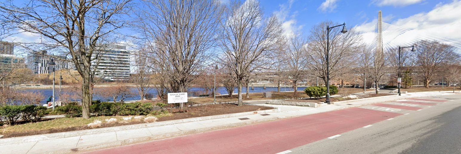
A 2022 photo looking north at the site of the Boston Nashua Street Heliport, reused as Nashua Street Park.
Thanks to Jonathan Westerling for pointing out this airfield.
____________________________________________________
Boston City Heliport (1MA3), Boston, MA
42.347, -71.044 (Southeast of Downtown Boston, MA)

Boston City Heliport, as depicted in the 1997 FAA report “Six Heliport Case Studies” (courtesy of Jonathan Westerling).
Jonathan Westerling reported, “For many years prior to the turn of the millennium, Boston had not one, but two downtown heliports!
However neither of them were operated by the City of Boston, which for various reasons, did not support their contribution to the downtown economy
and approved development projects that forced both of them to close without replacement.”
Jonathan continued, “The 'Boston Heliport' was established in 1987 by 'Boston Heliport Inc.'
The heliport was developed & operated as a privately-owned, public-use facility.
This is rare; most public-use heliports are publicly owned.”
A 1988 FAA Heliport study mentioned the Boston Heliport as a key piece of infrastructure with adequate demand, but uncertain support:
“Current evaluation indicates that the best site for a full-service facility is at the present location of the 'Boston Heliport',
a privately-owned, public-use heliport that has been in operation for a little over a year.
Boston is trying to delay development of the Boston City Heliport.
In August 1987, the City canceled a public meeting on the development of the Boston Heliport
and temporarily suspended the nearly completed Boston Heliport Study.
The City suspended the heliport study because it felt that due to the number of proposed projects in the South Boston area
the political acceptance of a heliport at that time would be too much."
The 1989 AOPA Airports USA listed the Boston Heliport as having a 75' x 70' concrete landing pad.
A 1989 "The Best of New England" article mentioned that scheduled aerial tours of Boston were available from the Boston Heliport from its tenants.
A February 2006 Rotor & Wing magazine article described the success of the Boston City Heliport:
"By 1992, its annual operations had topped 5,800. Noise complaints were virtually nonexistent & the FBO reportedly was profitable.”

The earliest photo which has been located of the Boston City Heliport was a 1995 aerial view.
It depicted a 4-bladed helicopter parked on the east end of a concrete heliport.

An undated photo of a hangar marked “Boston Heliport”, from the 1997 FAA report “Six Heliport Case Studies” (courtesy of Jonathan Westerling).

An undated photo of an Aerospatiale Dauphin parked at the Boston City Heliport, from the 1997 FAA report “Six Heliport Case Studies” (courtesy of Jonathan Westerling).
The 1997 FAA report “Six Heliport Case Studies” (courtesy of Jonathan Westerling) described the Boston Heliport:
"The TLOF & FATO of the Boston City Heliport are built on the original concrete floor of a former warehouse that is approximately 4' above ground level.
The surface shows signs of aging & weathering & appears to be in need of repair.
The area is 70' x 160'. The designated TLOF & 6 tie-down / parking positions can accommodate up to 6 SikorskyS-76-sized aircraft simultaneously.
If needed, there is space for an additional 12 helicopters in an adjacent 45,000 square-foot ground-level vehicular parking lot.
There is also a 6,000 square-foot maintenance & storage hangar that can accommodate 2-4 small or medium-size helicopters.
A converted mobile home is used as a terminal building. It has a waiting room, rest rooms, pilot flight planning room, and administrative offices.
There is lighting for night operations. Jet-A fuel is available from an underground storage tank & is dispensed via a pump & hose."
Shortly before its closure, the 1999 AOPA Airports USA directory listed the Boston Heliport as having a larger 210' x 70' landing pad.
A February 2006 Rotor & Wing magazine article summed up the fall of the Boston City Heliport accurately:
"The city decided to use the Boston City Heliport's land for a new convention center.
Operators & support groups fought in vain to have a heliport included in the city's plan.
Even in a city with no noise complaints, city planners are adopting the view that the public doesn't consider heliports the best use of land.
Unfortunately, this seems to be happening more & more.”
The Boston Heliport was closed by the end of 1999.
No public heliports were depicted in downtown Boston on the 2000 Boston Helicopter Route Chart.

A 2020 aerial view depicted the Boston Convention Center covering the site of the Boston City Heliport.
Thanks to Jonathan Westerling for pointing out this heliport.
___________________________________________________
Or if you prefer to contact me directly concerning a contribution (for a mailing address to send a check),
please contact me at: paulandterryfreeman@gmail.com
If you enjoy this web site, please support it with a financial contribution.
____________________________________________________
This site covers airfields in all 50 states.