Abandoned & Little-Known Airfields:
South-Central Massachusetts
© 2002, © 2026 by Paul Freeman. Revised 4/10/26.
This site covers airfields in all 50 states: Click here for the site's main menu.
____________________________________________________
Please consider a financial contribution to support the continued growth & operation of this site.
Dudley Intermediate Field (added 10/15/23) - Franklin-Norfolk Airport / Norfolk Airport / Heenan-Menfi Memorial Airport (revised 2/4/26) - Leicester Airport (revised 5/20/22)
Mendon Airport (revised 3/17/21) - Oxford Airport (revised 4/10/26) - Whittal Field / Grafton Airport (revised 3/17/21) - Windle Airport / Millbury Airport (revised 2/4/26)
____________________________________________________
Windle Airport / Millbury Airport, West Millbury, MA
42.172, -71.817 (Southwest of Boston, MA)
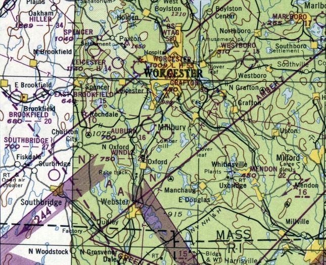
Windle Airport, as depicted on the July 1948 Boston Sectional Chart.
This small general aviation airport was evidently established at some point between 1947-48,
as it was not yet depicted on a 1939 aerial photo, the 1939 USGS topo map, or the 1947 Boston Sectional Chart.
The earliest depiction which has been located of Windle Airport was on the July 1948 Boston Sectional Chart.
It depicted Windle as having a 2,600' unpaved runway.

The earliest topo map depiction which has been located of Windle Airport was on the 1949 USGS topo map.
It depicted Windle as an open area without any specific runways, with 4 small buildings on the north side.

The earliest photo which has been located of Windle Airport was a circa 1950s aerial view looking northeast (courtesy of Fred Holland),
which showed a Grumman amphibian parked near a house, a barn with “Windle” painted on its rood, and what appears to be a hangar being expanded in the background.
A 1960 aerial photo depicted Windle Airport as having a single northwest/southeast unpaved runway,
but there were no aircraft visible on the field.

An undated aerial view from the 1965 MA Airport Directory (courtesy of Jonathan Westerling) depicted Millbury Airport as having a single 2,000' unpaved Runway 17/35,
with a few small buildings & 3 light aircraft on the northeast side.
The Manager was listed as Joseph Lemanski & the Fixed Base Operator as Windle Aviation.

A 12/7/67 USGS aerial view depicted Windle perhaps at the zenith of its popularity, with 8 light aircraft seen parked on the northeast side, near several small buidlings.
The field had 2 unpaved runways.
A 1971 aerial photo depicted Windle Airport as having a single northwest/southeast unpaved runway, with no sign of the crosswind runway seen in the 1967 picture.
There were no aircraft visible on the field, and the possible hangar on northeast side had been removed at some point between 1967-71.
Fred Holland recalled, “Windle Airport was still being used in 1972 - Boy Scouts held Scout-O-Rama’s at the field.
I remembered going to the Boy Scout event as a child.
It was owned or related to the same family that owned the Windle Mills in the town.”

The last topo map depiction which has been located of Windle Airport was on the 1978 USGS topo map.
It depicted Windle as having a single unpaved northwest/southeast runway & 4 small buildings on the northeast side.

The last aeronautical chart depiction which has been located of Windle Airport was on the December 1979 NY Sectional Chart (courtesy of Ron Plante).
It depicted Windle as a private airfield having a 2,000' unpaved runway.
Windle Airport appeared to have ceased operation by 1980, as a 1980 aerial view no longer showed the runway as remaining distinct.
Windle Airport was evidently closed (for reasons unknown) at some point between 1979-81,
as it as no longer depicted on the June 1981 NY Sectional Chart (courtesy of Ron Plante).
Windle Airport was no longer depicted on the 1984 USGS topo map.

A 2022 aerial view showed the Windle Airport site remained clear, but with no traces of the runways or other aviation infrastructure.
Thanks to Fred Holland for pointing out the closure of this airport.
____________________________________________________
Dudley Intermediate Field, Dudley, MA
42.047, -71.919 (West of Boston, MA)

Dudley Intermediate Field, as depicted on the 1924 NY-Boston Strip Chart (courtesy of Jonathan Westerling).
Jonathan Westerling reported, “It's hard to believe, but an emergency airfield, created almost 100 years ago along the newly created Boston - New York Air Mail route, sits largely unchanged to this day in Dudley, MA.
The Dudley Airport was created as part the New York - Boston Air Mail Route (which later became the New York - Boston Airway).
Along this route, pre-defined landing locations were created so pilots would have a safe place to land should they encounter weather or mechanical difficulties.
The Dudley Airport was located 1/2 mile northeast of town at the top of what was known as 'Bates Hill' named after the owners of the parcel.
The top of the hill had been cleared, and its 21 acres (according to Airway Bulletin #126) provided plenty of space for the US Postal Service's DH-4 biplanes to land.
There was a pre-existing water tank perched on one corner of the airport, which is still there [as of 2023].
The larger city 2 miles to the east of the airport was Webster, MA, and so the airfield was often colloquially referred to as the Webster Airport.”
The earliest depiction which has been located of Dudley Intermediate Field was on the 1924 NY-Boston Strip Chart (courtesy of Jonathan Westerling).
Jonathan Westerling continued, “In 1926 the New York - Boston Air Mail Route was contracted from the Post Office to an outside company.
Colonial Air Transport received Contract Airmail Route (CAM) #1, between Boston & New York, NY.
Colonial Air Transport began operation on 7/1/26, carrying mail & passengers in single-engine Fokker Universal aircraft (according to the Smithsonian's Postal Museum).”

The 7/6/27 Commerce Department Airway Bulletin (courtesy of Jonathan Westerling) depicted Dudley Intermediate Field as having a 1,625' northeast/southwest landing distance, with a beacon tower & a 30' water tank on the southeast side.
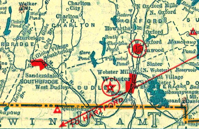
The 1929 Air Trails Directory (courtesy of Jonathan Westerling) described Dudley Intermediate Field as having a 1,625' runway.
According to the article “Plane Wrecked In Webster” in the 5/1/29 New Britain Herald (courtesy of Jonathan Westerling), “On the night of 4/30/29, a U.S. Mail plane belonging to Colonial Air Transport, Inc.
was attempting to take off from the Webster – Dudley Air Field when the aircraft failed to gain sufficient speed on the muddy field & crashed into a stone wall.
The plane was bound for Hartford, CT when the crash occurred. The pilot & his passenger (the night supervisor of the NY–Newark line) were not injured.
It should be noted, however that 3 brave pilots lost their lives flying the mail along the New York to Boston route.”
According to the 1930 Airway Bulletin #126, between 1927-30 a parcel on the east side of the airfield was added to the field allowing for 2 landing directions laid out in an X-formation, measuring 1,725' & 1,625'.
Dudley Intermediate Field was not depicted on the 1931 USGS topo map.

The 4/30/30 Commerce Department Airway Bulletin (courtesy of Jonathan Westerling) depicted Dudley Intermediate Field as having a 1,725' northeast/southwest landing distance, with a beacon tower & water tank on the southeast side.
The 1932 Airway Guide (courtesy of Jonathan Westerling) showed the Dudley Airport along the NY-Boston Airway at the location of Airway Beacon #17.

The 1933 Boston Sectional Chart (courtesy of Jonathan Westerling) showed that although Airway Beacon #17 was located in the same place a year later, there was no longer an airfield at that location.
The 1934 Sectional Chart showed that the Boston-NY Airway route was re-oriented to run further south of Dudley, and Beacon #17 was decommissioned.
Dudley Intermediate Field was not depicted on the 1938 USGS topo map.

A 1991 aerial photo (courtesy of Jonathan Westerling) showed the area of Dudley Intermediate Field remained clear, with the characteristic Bates Hill remaining on the southeast corner of the former airfield.

A 2012 photo by Jonathan Westerling, which he noted “The clearing is still exists almost identical to as it existed in the 1930s with the town water tank now enclosed in an earthen berm on the southeast side of the field.”

A 2012 photo by Jonathan Westerling, which he noted “A small farm, Pleasant Hill Farm on the southern perimeter of the airport has put up a windsock, though there's no other indication that the field has been used for takeoffs or landings recently.”
Thanks to Jonathan Westerling for pointing out the closure of this airport.
____________________________________________________
Oxford Airport (43M), Oxford, MA
42.152, -71.837 (West of Boston, MA)

A 12/1/67 USGS aerial view of the northern portion of Oxford Airport.
Oxford Airport was not yet depicted on a 1966 aerial photo.
Oxford Airport opened in 1966, according to the Town of Oxford (courtesy of Jim Daigneau).
Jim Daigneau recalled, “I grew up & fixed my commitment to flying at Oxford Airport. I was 12 when the airport opened in 1966 & it was a thrill.
My friends & I would ride our bikes up Federal Hill Road to the airport.
It was a little surprise for the uninitiated as the Runway 02 asphalt, literally, joined the road.
Only the threshold lights & a couple of telephone poles separated the two.
There was a 'Caution-Low Flying Aircraft' sign, but that provided little comfort to those surprised by an airplane swooping in front of their windshield.
With only 2,000' available & trees at both ends, one didn’t want to waste any landing surface.”
Jim continued, “The hangar on the southeast corner of the field was built by Phil Hopkins, an architect.
His son, Billy, was one of my best friends through junior high. We once helped Mr. Hopkins wash his beautiful Skylane.
As thanks, he took us for a quick ride around the pattern & I was lucky enough to ride shotgun.
If there was ever any doubt in my mind before that ride (there wasn’t), there certainly wasn’t after we landed. I was 100% committed to a flying career.”
Jim continued, “The other building on the east side of the field was the Fixed Base Operator shack & maintenance hangar.
Both were small with just the basic facilities. The fuel pumps were on the north side of the hangar.
The hangar on the west side of the runway was built by Richard Olney. He ran a busy aircraft painting business for many years.
I watched him work several times. He was very methodical & meticulous.
I don’t know what he charged for an Imron paint job, but I do know he did not lack for customers.
Most of the jobs were single-engine, but I remember seeing a Navajo there from one of the New England commuter airlines at the time.”
The earliest photo which has been located of Oxford Airport was a 12/1/67 USGS aerial view.
It depicted Oxford Airport as having a single north/south runway.
Oxford Airport was not yet depicted on the February 1968 Boston Sectional Chart.

The earliest airport directory depiction of Oxford Airport which has been located was in a 1968 Airport Directory (courtesy of Jim Daigneau),
which depicted Oxford as having a single 2,200' paved Runway 2/20, with 2 small buildings on the southeast side.
Jim Daigneau recalled, “Stan Krupinski was my first flight instructor when I began flying in 1970.”
 26.169
-97.713
26.169
-97.713
The earliest aeronautical chart depiction which has been located of Oxford Airport was on the March 1970 Boston Sectional Chart,
which depicted Oxford as having a single 2,100' paved north/south runway.
A 1971 aerial view depicted Oxford Airport as having a single paved north/south runway, with a dozen light aircraft & 2 small buildings on the southeast side.
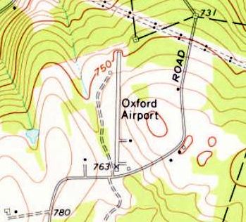
The 1973 USGS topo map depicted Oxford Airport as having a single paved north/south runway, with 2 small buildings on the southeast side.
David Gray recalled, “Oxford Airport... I have flown into it on many occasions back in the mid/late-1980s.
It was well-known in 'the day' for it's aircraft paint & interior shop / Fixed Base Operator on the field.
It was known for it's good, quality work at reasonable prices.
The paint shop was shut down, or was forced out of business with new EPA regulations governing the capture & control of spray paint,
i.e. a giant spray booth with HEPA approved filters!
Oxford Airport was definitely not one of 'New England's Picturesque Airfields'.
It was somewhat ramshackle & cluttered with lots of non-aviation junk, such as cars, trucks, boats,bulldozers etc.
The runway was narrow, which gave the illusion of being a lot shorter than it really was.
It was plenty long enough to accommodate the Cessna 150 & 172 heavies I flew in & out of it with.
I think it may have been a little longer than 2,200' [as listed in the 1968 directory].
There were always seemed to be light, and even cabin-class twins being painted at the FBO,
and most of those like runways in the 3,000'+ range, but I imagine with just a pilot & minimal fuel load
the 2,200' would not, and did not present an insurmountable obstacle to a qualified pilot.”
Jim Daigneau recalled, “I remember at one point sometime in the 1970s there was talk of building a crosswind runway
across the north end of Runway 02/20 but nothing was ever done to my knowledge.
I flew out of Oxford several times through the 1970s & early 1980s.
Stan Krupinski came to manage Oxford after spending 20 years at Southbridge.
He had a beautiful J3 which I flew quite a bit, as well as the typical Cessna 150s & 172s on the line.
He also kept a pristine PT-17, which he had restored after WW2.
He came by the airplane honestly as he was a civilian contract instructor for the Army during the war.
I logged my last landing at Oxford in 1986 in a Beech Sierra & remarked, 'Runway not so good'.”"

The earliest photo which is available of Oxford Airport was a 1987 photo of Philip Hartmann's father's Cessna 172, with hangars in the background.

A winter 1991 photo of a Piper TriPacer & other single-engine aircraft at Oxford Airport (courtesy of Philip Hartmann).

A winter 1991 photo of a Cessna 172 & other single-engine aircraft at Oxford Airport (courtesy of Philip Hartmann).

The earliest aerial photo which has been located of Oxford Airport was a 1996 aerial view looking northwest.
It depicted Oxford Airport as having a paved Runway 2/20, with a total of 14 light single-engine aircraft parked on the west & southeast sides near some small buildings.
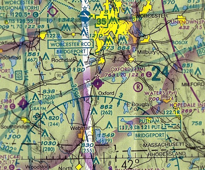
The last aeronautical chart depiction which has been located of Oxford Airport was on the May 2005 Boston Sectional Chart,
which depicted Oxford as having a single 2,000' paved north/south runway.

The last photo which has been located showing Oxford Airport still in operation was a 2005 aerial view looking northwest.
It depicted Oxford Airport as having a paved Runway 2/20, with a total of 11 light single-engine aircraft parked on the west & southeast sides near some small buildings.
Scott Dunn reported, “Oxford (43M) was listed in the 7/7/05 Airport/Facility Directory, but no longer appeared on the November 2005 NY Sectional Chart.”

A 9/17/06 aerial view by Scott Dunn looking east at the closed Oxford Airport,
with a closed-runway “X” symbol visible on the runway.
Jim Daigneau reported in 2015, the site of Oxford Airport “is currently a storage site for Eagle (trailer) Leasing Company.”

A 2016 aerial view looking northwest at the Oxford Airport site shows the runway pavement appears to have been removed, but the runway alignment is still recognizable.
Two of the hangars remain, but one was evidently removed at some point between 2005-2016.
The site of Oxford Airport is located northeast of the intersection of Depot Road & Federal Hill Road.
____________________________________________________
Leicester Airport, Leicester, MA
42.275, -71.912 (West-Southwest of Boston, MA)

Leicester Airport, as depicted on the September 1944 Boston Sectional Chart (courtesy of Chris Kennedy).
Leicester Airport was apparently built at some point in 1944,
as it was not yet depicted on the May 1944 Boston Sectional Chart.
The earliest depiction of Leicester Airport which has been located
was on the September 1944 Boston Sectional Chart (courtesy of Chris Kennedy),
which depicted Leicester as a commercial/municipal airport.

The 1945 AAF Airfield Directory (courtesy of Scott Murdock) described the Leicester Airport
as a 54 acre irregularly-shaped field within which were 2 asphalt runways, measuring 1,500' NNW/SSE & 1,320' northwest/southeast.
The field was said to have a single 50' x 40' cinderblock hangar, and to be privately owned & operated.
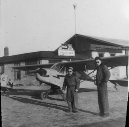
The earliest photo which has been located showing Leicester Airport was a 1946-47 photo (courtesy of Sandy Skinner)
of Sandy Skinner's father, Paul Hodgdon (on right). & another person in front of a Piper Cub & the Leicester Airport Snack Bar, with the windsock pole on top of the hangar.
Charles Danforth recalled, “My first ride in a plane was a 10 or 12 minute flight from Leicester Airport, between 1946-49.
At some point my high school (Leicester) class or the school was invited for flights. Mine was an individual flight.”

Leicester Airport was depicted on the 1950 USGS topo map, but it was unlabeled.
The 2 runways were depicted, as well as the single hangar/office at the northwest corner of the field.
Paul Stakun recalled, "I was born & raised in Leicester and remember the airport very well.
When I was a kid in the 1950s, there were lots of former WWII pilots who flew out of there
and there was a lot of flight instruction going on.
I remember many of the old aircraft that flew out of Leicester including Howard DGAs,
Timm N2T, Stinson Reliants, Voyagers, as well as the multitude of J3s, Aeronca Champs, Cessna 140s.
My interest & subsequent career in aerospace was born there."
Edwin More recalled, “An old high school buddy of mine worked at the Leicester Airport when he was in high school.
The operator there used to loan him a J-3 Cub during the week of the school year
so that he could commute from Brainard Field in Hartford, CT.”

A November 1955 aerial view looking northwest (from the MA Aeronautics Commission) depicted Leicester Airport as having 2 runways in an X-shape, with some buildings on the north side.
The 1959 Boston Local Aeronautical Chart (courtesy of Chris Kennedy)
depicted Leicester as a public-use airport with a 2,200' hard-surface runway.
The status of Leicester Airport apparently changed from a public-use field to a private field at some point between 1959-62,
as it was labeled "Leicester (Pvt)" on the 1962 Albany Sectional Chart (courtesy of Mike Keefe) & subsequent charts.
Leicester Airport was described in the 1962 AOPA Airport Directory as having 2 bituminous runways: 2,200' Runway 13/31 & 1,550' Runway 18/36.
The operator was listed as Earl Howland.

The last photo which has been located showing Leicester Airport in operation was a 4/29/63 USGS aerial view.
It depicted Leicester Airport as having 2 paved runways, with a paved ramp & several buildings on the northwest side, but there were no aircraft visible on the field.
By 1965, Leicester Airport had apparently started to deteriorate,
as the remarks in the Aerodromes table on the 1965 Boston Sectional Chart (courtesy of John Voss) said "Private. Pavement Broken & Cracked."
The field was described as having 2 runways, with the primary being an 1,800' asphalt runway.

The last aeronautical chart depiction which has been located of Leicester Airport was on the March 1969 Boston Sectional Chart.
It depicted Leicster as a private airfield having 2 paved runways, the longest being 1,800'.
Leicester Airport was apparently closed (for reasons unknown) at some point in 1969,
as it was no longer depicted on the September 1969 Boston Sectional Chart or the 1970 USGS topo map.
A 1971 aerial view depicted Leicester Airport as having 2 paved runways, with a paved ramp & several buildings on the northwest side.
Leicester Airport was not listed among active airfields in the 1976 AOPA Airport Directory (according to Chris Kennedy).
Leicester Airport was depicted on the 1991 USGS topo map, labeled "Airfield (Abandoned)".
According to sailplane pilot Fred Looft, "It has been abandoned for as long as I can remember (which is not that long, 1980s for sure),
and I'm told that it was abandoned about the time Worcester was created.
It used to have a great dance club I'm told after it closed, and was used for model flying, etc."

A 1995 USGS aerial view looking east showed that the cleared area still existed of both of the former Leicester Airport runways, as well as some of the former runway pavement.
A paved ramp still existed at the north end of the former Runway 18/36, along Marshall Street, as well as at least one former airport building.

A 2003 photo by Jonathan Westerling at the site of Leicester Airport.
Jonathan reported, "A look at the structure which presumably functioned as a hangar.
The pavement in front is more recent than that on the runways, and vehicle parking lines are still visible."
Jonathan Westerling reported, "I visited the old Leicester airport in November of 2003.
This was my second visit to the site - I had been there previously in 1995, but did not bring a camera with me.
The faded sign in front of the airfield says 'Highlights';
presumably the name of the dance club [which occupied the hangar after the airfield closed].
The runways are still walkable for most of their length,
but encroached with brush & certainly not usable as an airfield any longer.
I explored the rear of the building looking for any signs of aeronautical usage, but none were apparent.
A fair portion of the roof of the building has caved in.
My guess is that Leicester was started by a fellow with a lot of land & money
(thus the pool, large building, and 2 runways).
What other private field in MA had 2 PAVED runways back in the 1950s."

A 2003 photo by Jonathan Westerling at the site of Leicester Airport.
Jonathan reported, "Looking north from the runway intersection up Runway 36 towards the road.
The building you see there is a new house across the road. The hangar is off to the left."

A 2003 photo by Jonathan Westerling at the site of Leicester Airport.
Jonathan reported, "Looking south from the runway intersection down Runways 13 & 18.
Note the remains of the pavement, most of which has disintegrated to rubble throughout the site."

A circa 2001-2005 aerial view looking south at the remains of Leicester Airport.

A 6/17/16 photo by Labtec looking along the barely-recognizable remains of a former Leicester Airport runway.

A 6/17/16 photo by Labtec of the remains of the Leicester Airport paved ramp & office building.

A 6/17/16 photo by Labtec of the interior of the Leicester Airport office building.

A 2019 aerial view looking east showed that the orientation of the 2 former Leicester Airport runways was still perceptible in the woods,
and at least 1 former airport building remained on the north side (left side of photo).
The site of the Leicester Airport is located on the south side of Marshall Street, west of its intersection with Paxton Street.
____________________________________________________
Whittal Field / Grafton Airport, North Grafton, MA
42.225, -71.715 (West of Boston, MA)

North Grafton's Whittal Field, as depicted on the 9/28/27 Commerce Department Airway Bulletin (courtesy of Jonathan Westerling).
Massmoments.com reported, “In 1925 an informal group of Worcester businessmen & flying enthusiasts began to scout potential sites for an airport in Worcester County.
But, as often happens when committees are involved, the plans stagnated.
Finally, Whitin Whittall grew impatient with the delays. He used his own money to hire engineers to survey possible sites.
Inches Farm field in North Grafton came up at the top of the list. Whittall took out options to purchase the land, then drummed up excitement & support from Worcester businessmen.
Within three weeks, the group had the funds to incorporate, and by 10/3/27, two runways & 2 hangars were open for business. Whittall Field became Worcester's first airport.
Whitin Whittal succeeded not only in getting the airport built but also in spreading his excitement about flying.
On 10/12/27, the day the airport was dedicated, roads around the airport were jammed for miles.
A huge crowd turned out to witness the opening ceremonies and flight demonstrations, including daring maneuvers performed by a female German pilot.
A festival atmosphere prevailed, in spite of endless speeches by politicians & dignitaries.”
The earliest official reference to Whittal Field which has been located was in the 9/28/27 Commerce Department Airway Bulletin (courtesy of Jonathan Westerling),
which depicted North Grafton's Whittal Field as having 2 perpendicular unpaved runways, with 3 buildings along the east side.

A poster for the “Worcester Air Pageant” (courtesy of the Grafton Historical Society, via Steve Cohn)
said that it was held on 10/8/27 in North Grafton, but did not specify an airport by name.

The 1929 Rand McNally Air Trails Map of Massachusetts (courtesy of Mike Rossi) depicted the airport in North Grafton.
However there was no listing of an airport in Grafton (or North Grafton) in The Airport Directory Company's 1933 Airport Directory (according to Chris Kennedy).

The earliest aeronautical chart depiction which has been located of Whittall Field was on the March 1933 Boston Sectional Chart.
It depicted Whittall as an auxiliary airfield.
The 1934 Department of Commerce Airport Directory (courtesy of Chris Kennedy) described Grafton as a municipal airport
consisting of an irregularly shaped sod field, containing a total of 4 runways (with the longest being 3,000').
Sandy Skinner reported that a handwritten note indicated that her father took his first plane ride at age 13 in a Taylor Cub at Grafton Airport in 1936.
There was no listing of an airport in Grafton in The Airport Directory Company's 1937 Airport Directory (courtesy of Bob Rambo).
The earliest photo which has been located of Grafton Airport was a 1938 aerial view.
It depicted 2 hangars & 2 light single-engine planes on the east side of a grass airfield.

The May 1941 Boston Sectional Chart (courtesy of Chris Kennedy) depicted Grafton as a commercial/municipal airport.

The earliest photo which is available of Grafton Airport was an undated aerial view looking northwest
from The Airport Directory Company's 1941 Airport Directory (courtesy of Chris Kennedy).
It described Grafton as a commercial airport consisting of an irregularly shaped sod field,
containing a total of 4 runways (with the longest being the 3,600' northwest/southeast strip).
What appeared to be 3 buildings along the east side of the field, along the west side of the road.
Massmoments.com reported, “In the years leading up to World War II, the field was especially busy with the Civil Pilots Training program.”

The 1944 USGS topo map depicted the “Grafton Airport”, but only as an open, undefined area,
with a few small buildings along the west side of Airport Road.
Massmoments.com reported, “For 18 years, Whittall Field was one of the busiest spots in Worcester County.
Until 1945, the field hosted airplanes such as Jennies, Robins, Wacos, Fords, Stearmans, Cubs, and Taylorcraft;
special charters brought visiting performers & dignitaries, and pioneers such as Wiley Post made stopovers on around-the-world flights.
World War II brought major advances in aircraft design, and it became clear that the old farm fields would soon be too small for modern aircraft.
On 5/4/46, a new Worcester Airport was dedicated near the city's west side.
The old Whittall Field was sold for a housing development in 1951.”

The depiction of Grafton Airport on the 1953 USGS topo map did not differ from that depicted on the 1944 USGS topo map -
basically an open, undefined area, with a few small buildings along the west side of Airport Road.

The last aeronautical chart depiction which has been located of Grafton Airport was on the May 1953 Boston Sectional Chart.
It depicted Grafton as having a 3,000' unpaved runway.
Grafton Airport was evidently closed at some point in 1953,
as it was no longer depicted on the December 1953 Boston Sectional Chart.
The 1965 Sectional depicted that the Massachusetts Turnpike had been built along the southern edge of the site of the former airport,
which may have been among the reasons for its closure.
A 1967 aerial photo showed the Grafton Airport hangars had been removed, houses had been built along the east side,
and a baseball diamond had been built on the southern edge, but the majority of the airport site remained unredeveloped.
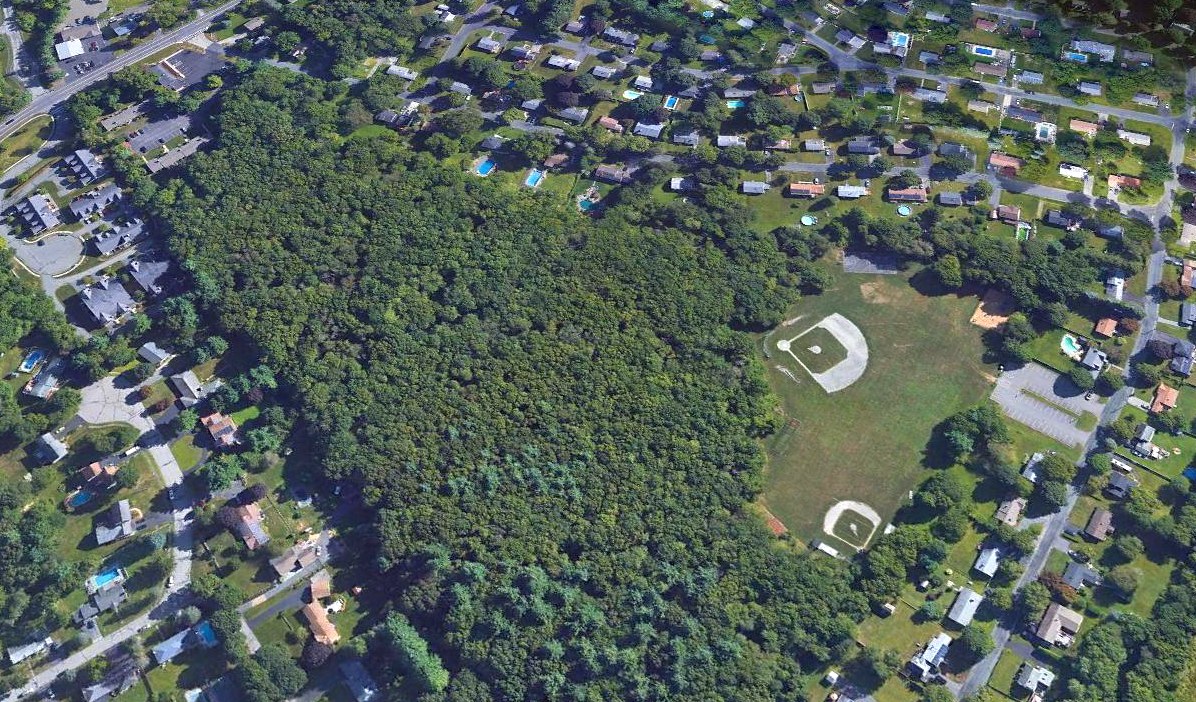
As seen in a 2019 USGS aerial view looking northeast, there does not appear to be any trace remaining of Grafton Airport, with the majority of the site covered by trees.
As of 2021, street maps label the site of Grafton Airport as “Airport Park”.
The site of Grafton Airport is located south of the intersection of Route 122 & Airport Road.
Thanks to Steve Cohn for pointing out this airfield.
____________________________________________________
42.1, -71.56 (Southwest of Boston, MA)

Mendon Airport, as depicted on the 1929 Commerce Department Airway Bulletin (courtesy of Jonathan Westerling).
The date of establishment of Mendon Airport has not been determined.
According to Paul Doucette, “P. A. Millis bought it at the end of 1927, but I do not know when he actually started operations [of the airport].”
The earliest depiction which has been located of Mendon Airport was on the 1929 Commerce Department Airway Bulletin (courtesy of Jonathan Westerling).
It depicted Mendon as an L-shaped field with a cluster of buildings at the north corner.

The 1932 Airways Guide (courtesy of Jonathan Westerling) depicted Mendon Airport as the first airport along the airway southwest of Boston.

Mendon Airport, as depicted on the 1933 Airways Chart (courtesy of Jonathan Westerling).
According to Skylanes, Sabatino “Sabbie” Ludovici moved his Sabbie's Flying Service to Mendon Airport in 1935, where he founded Skylanes.

The earliest photo depiction which has been located of Mendon Airport
was a 1935 photo (courtesy of Doug Taylor) of a group from Sabbie's Flying Service & a monoplane & biplane in front of a Mendon Airport hangar.
According to the MA Aviation Historical Society, as of 1935 Mendon Airport was a commercial field,
with the owner being P.A. Millis, and the operator being Mills Air Service.
Other commercial operators were Herman Ryan & Arthur Scruten.
The field consisted of an L-shaped 108 acre property with 3 sod landing strips, with the longest being the 1,800’ north/south strip.

A circa 1930s photo (courtesy of Doug Taylor) of a monoplane & biplane in front of a Mendon Airport hangar.

A circa 1930s photo (courtesy of Doug Taylor) of an unidentified biplane on a Souvenir of a flight from Mendon Airport.

The 1937 MA Airport Directory (courtesy of Jonathan Westerling) depicted Mendon Airport as an irregularly-shaped property outline.

A 5/19/38 photo (courtesy of Doug Taylor) of a Stinson biplane conducting the first airmail flight from Mendon Airport.

A 7/28/38 photo (courtesy of Doug Taylor) of a Stinson Reliant monoplane at Mendon Airport.

A photo (courtesy of Doug Taylor) showing wrecked hangar at Mendon Airport as a result of the 9/21/38 hurricane.
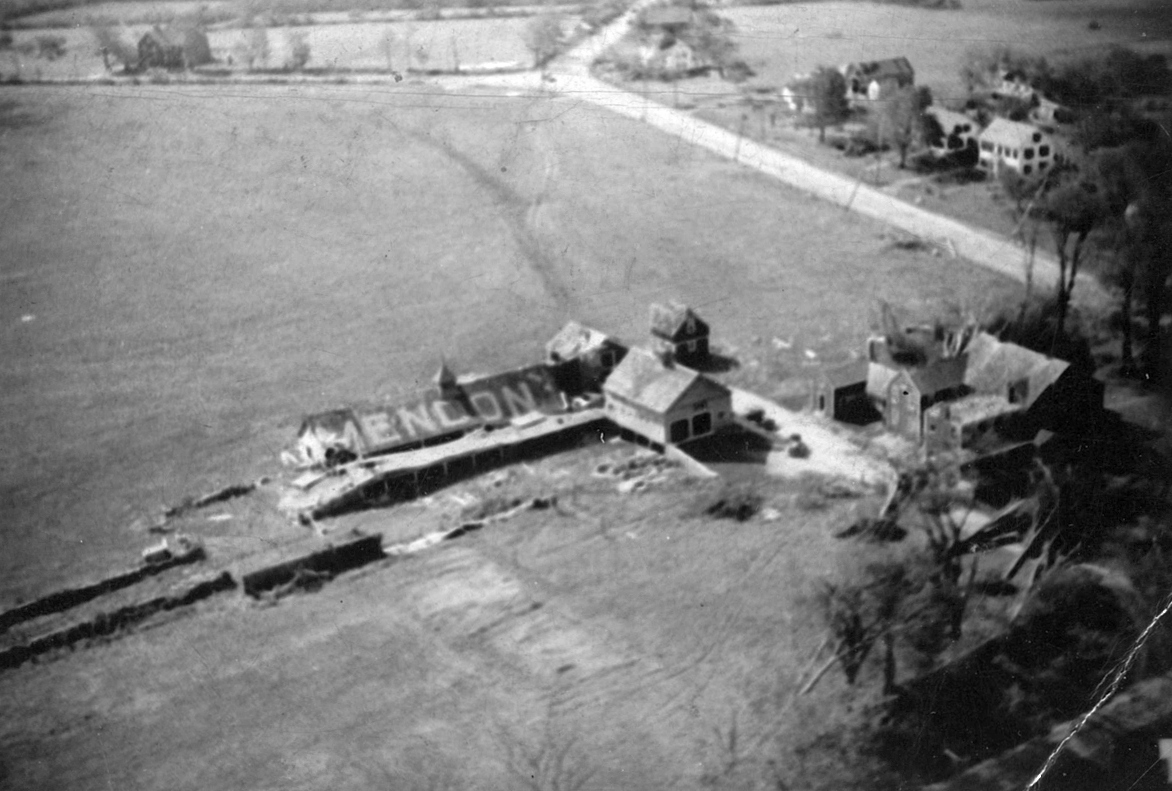
An undated aerial view looking northwest at the Mendon Airport hangar (from the George Armitage collection, courtesy of Kim Hetland, via David Tremblay),
which appears to show the hangar damage after the 9/21/38 hurricane.

An 11/10/38 aerial view showed the buildings at the north end of Mendon Airport still showing damage as a result of the 9/21/38 hurricane.
According to Skylanes, “By 1938, the service had 3 airplanes: a Piper Cub, a Taylorcraft, and the original Waco, but the hurricane of 1938 did a lot of damage.
The 3 were repaired & 2 more Taylorcrafts were added to the fleet.
Eventually, Skylanes moved to North Central State Airport.”
The earliest topo map depiction which has been located of Mendon Airport was on the 1943 USGS topo map.
It erroneously depicted Mendon Airport on the opposite (west) side of Millville Road,
which may have been a case of intentional wartime map deception.

The earliest topo map depiction which is available of Mendon Airport was on the 1944 USGS topo map.
It depicted “Mendon Landing Field” as an irregularly-shaped property with a single small building on the north corner.
The 1945 Boston Sectional Chart depicted Mendon as a commercial/municipal airport, also designated Airway Site 16.
According
to Paul Doucette, “There was a beacon located a short ways from
the airport.”
According to the MA Aviation Historical Society, as of 1945 Mendon Airport had a 1,800' seeded sod north/south runway,
and the field measured 96 acres, with 3 hangars & an office.

An August 1946 aerial view looking north at Mendon Airport (from the MA Aeronautics Commission)
depicted the field as having a north/south unpaved runway & a cluster of hangars on the northeast side.

The last aeronautical chart depiction which has been located of Mendon Airport was on the 1949 Boston Sectional Chart (courtesy of Jonathan Westerling).
It depicted Mendon as having a 2,200' unpaved runway, designated Airway Site 16.

A circa 1950s photo (courtesy of Doug Taylor) of 2 Piper Cubs in front of a hangar & an office at Mendon Airport.

A circa 1950s photo (courtesy of Doug Taylor) of hangars at Mendon Airport.
According to Paul Doucette, “P. A. Millis... sold it [the Mendon Airport property] in 1951.
I’ve been told by old 'townies' the last person to land an aircraft at the airport was John Quirk.
He lived in Mendon, was a naval pilot in WWII, and operated the New England Steak House Restaurant.”
Mendon Airport was evidently closed (for reasons unknown) at some point between 1945-55,
as it was no longer depicted on the 1955 Boston Sectional Chart.
“Mendon Landing Field” was still depicted on the 1964 USGS topo map.
A 1967 aerial photo showed the eastern hangar still had “Mendon” painted on its pointed roof.
Peter Mulcahy recalled of the Mendon Airport site, “In the 1960s Jessie White Marine took over the hangars & the field for boat storage.”
David Gray recalled, “Even while it was being used as a marina / boat storage area, someone had an airplane[s] there.”
The 1971 USGS topo map no longer depicted the airport, but still depicted an open unlabeled field with a few small buildings on the north side.
A 1971 aerial view showed both hangars had their roofs repainted,
and 3 other large buildings had been added to the site.
A 1978 aerial view showed the eastern hangar (with the pointed roof) had been removed at some point between 1971-78.

A 1990 street map (courtesy of Paul Doucette) still depicted the airway beacon on the south side of the Mendon Airport property.

A 4/11/12 photo by Paul Doucette of the hangar which remains at the site of Mendon Airport.

An 8/24/13 aerial view showed the curved-roof hangar remained on the north side of the site of Mendon Airport.
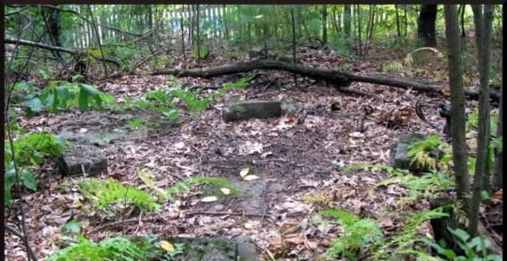
A September 2014 photo of the remains of the 4 concrete footings of the Mendon Airport beacon tower (courtesy of Paul Doucette).
The site of Mendon Airport is located southeast of the intersection of Millville Road & Route 16.
Thanks to Paul Doucette & David Gray for pointing out this airfield.
____________________________________________________
Franklin-Norfolk Airport / Norfolk Airport / Heenan-Menfi Memorial Airport (MA07, 32M), Norfolk, MA
42.13, -71.373 (Southwest of Boston, MA)

Franklin-Norfolk Airport, as depicted on the July 1946 Boston Sectional Chart.
Susan Fletcher Guagliumi recalled, “My grandparents, Robert & Elza Fleischer, purchased the land back in the early 1940s.”
This general aviation airport was evidently established at some point between 1945-46,
as it was not yet listed among active airfields in the 1945 AAF Airfield Directory (courtesy of Scott Murdock)
nor depicted on the December 1945 Boston Sectional Chart.
The earliest depiction of which has been located of Franklin-Norfolk Airport was on the July 1946 Boston Sectional Chart.
It depicted Franklin-Norfolk as a commercial/municipal airport.
Susan Fletcher Guagliumi recalled, “When when my father, Jordan Fletcher, came out of the service (he had been a glider pilot)
he opened Norfolk Airport on that property, hoping to get people interested in flying lessons.
My parents both flew & there were family stories about them taking my older brother up for a flight around the area to get him to sleep when he was a baby.
I also remember stories about lots overshooting the runway & ending up in the lake.”

The earliest photo which has been located of Franklin-Norfolk Airport was an August 1946 aerial view.
It depicted Norfolk as having 2 grass runways, with a small hangar on the northeast side, and a light single-engine plane was visible low over the runway.

A 1947 photo (courtesy of Susan Fletcher Guagliumi) of a light single-engine plane taking off from Norfolk Airport.

A 1948 aerial view looking northwest (courtesy of Susan Fletcher Guagliumi) depicted Norfolk Airport as having 2 grass runways.

A 1948 photo (courtesy of Susan Fletcher Guagliumi) of several light single-engine planes parked near the Norfolk Airport hangar.

A 1948 photo (courtesy of Susan Fletcher Guagliumi) of several light single-engine planes parked near the Norfolk Airport hangar.
Walter Stafford recalled of Norfolk Airport, “I flew out of there as a passenger with my father in the summer of 1948.
He did his primary training there for the private pilot's license & finished in 1948 (I have his log books).
He & my mother both flew out of there in Cessna 120's & 140's. He also owned & flew a Cessna 195.”
The 1952 Commonwealth of Massachusetts Airport Directory (according to Jonathan Westerling) listed Norfolk as being a “restricted use airport”.
Susan Fletcher Guagliumi recalled, “After my father & mother divorced, my grandparents sold the property to to the Marshalkowskis who plowed up the runways & grew corn for a while.
Over the following years the airport opened & closed a number of times.”
Norfolk Airport may have been gone through a period of closure,
as it was not depicted at all on the November 1954 Boston Sectional Chart (according to Chris Kennedy).
Rick Hersey recalled, “My Dad kept his Stinson 10 at Norfolk for many years.
I remember the man who ran it was named Charlie Sia, this was during the late 1950s & early 1960s.”
Norfolk Airport was once again depicted on the 1960 Boston Local Aeronautical Chart (courtesy of Mike Keefe).
It depicted Norfolk as a private airfield with a single 3,000' turf runway.
The earliest photo which has been located of Norfolk Airport was a 1961 aerial view.
It had a single north/south grass runway, with 6 light aircraft visible near a single hangar on the west side of the field.
The 1962 Boston Local Aeronautical Chart (courtesy of Mike Keefe) depicted Norfolk as a private airfield with a single 3,000' turf runway.
At some point between 1962-65, the status of Norfolk had changed to a public-use airport,
as that is how it was depicted on the 1965 Boston Sectional Chart (courtesy of John Voss).
The Aerodromes table on the reverse side of the chart described the field as consisting of a single 2,700' turf runway.

An undated aerial view from the 1965 MA Airport Directory (courtesy of Jonathan Westerling) depicted Norfolk Airport as having a single 2,700' unpaved Runway 2/20,
with 10 light aircraft parked near a few small buildings on the northwest side.
The Manager & Fixed Base Operator was listed as Charles Sia.
The 1967 AOPA Airports USA Directory (according to Jonathan Westerling) listed Norfolk as having a 2,700' sod Runway 18/36.

The 1968 Boston Sectional Chart (courtesy of Mike Keefe) depicted Norfolk as a public-use airport having a 2,700' unpaved runway.
John Cross recalled of Norfolk Airport, “The MIT Soaring Association was based there starting in 1968.”
A 1968 aerial view depicted Norfolk as having a single northwest/southeast runway,
with several dozen light aircraft visible on the west side of the field.
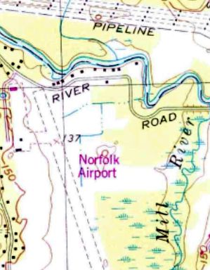
The 1970 USGS topo map depicted Norfolk Airport as having a single unpaved northwest/southeast runway, with a ramp & a few small buildings on the west side.
John Cross recalled of Norfolk Airport, “That is where I learned to fly with the MIT Soaring Association. I was there 1972-76.
It had a paved runway with an overrun to the south (which is where we staged our gliders).
I think there were maybe 10-15 airplanes tied down out there during that time.
On nice summer days we might have 3-6 gliders operating. There was a fair amount of power traffic there as well.
The north end of the field had trees which were right at the end of the runway.”
David Southern recalled, “Norfolk Airport... I worked the line pumping gas for flying time when I was a kid (John paid for my Private & Instrument licenses).
I started there when I was 14 in 1974. I worked for John & Joe until I left to go to Army Flight School in 1981.
John & Joseph Menfi purchased Norfolk Airport from Charlie Sayer when they left the Army.
Both John & Joe were Army Aviators who were decorated veterans during the Vietnam War & their decorations were displayed proudly in their office.
Both received the Bronze Star for their actions during the war.
John & Joe originally ran a Fixed Base Operation with a Cessna-approved flight school (using Cessna's audio/visual training programs)
along with a maintenance facility called Norfolk Aviation out of the main building during the 1970s.
In addition to Norfolk Aviation, Jim Godivich ran another maintenance facility called Superior Aero out of the main building.
During the mid-1970s there was another flight school that was short-lived.
John & Joe then moved their flight school to the small wood building.
It was during this time frame that there was both the MIT flying club & also the glider club that operated out of Norfolk.
In addition, there was a company that towed aerial banners on the weekends.”
David continued, “John ran the day-to-day operations at Norfolk Airport.
It was during this time frame of the mid-1970s that John started flying for Ernie Boch of the Boch car dealership fame.
Ernie had a Piper Navajo that was hangared at Norfolk.
In addition John was the pilot for George Lutski of Lutski Enterprises which if I remember was out of North Attleboro.
George had a Piper Seneca that was hangared in the metal hangar at the end of the airport by Runway 18.
Walter Woods of Woods Engineering kept a Cessna 185 on floats in the concrete section of the metal hangar at the end of Runway 18.
The trailer at the end of Runway 18 - a number of different flight instructors lived there at various times.”

The June 1975 Boston Terminal Aeronautical Chart (courtesy of Mitchell Hymowitz)
depicted Norfolk as having a 2,700' unpaved runway.
A 1978 aerial view depicted a very well-used airport, with several dozen light aircraft visible on the northwest side of the field.

The 1979 Flight Guide (courtesy of Jonathan Westerling) depicted Norfolk as having a single 2,700' paved Runway 18/36,
with a ramp & several buildings on the northwest side of the field.
The Flight Guide included the note, “Caution, aircraft taxiing on west side of runway.”
The 1979 AOPA Airports USA Directory (according to Jonathan Westerling) listed the width of Norfolk's paved runway as a generous 150'.
David Southern recalled, “The maintenance facility of Norfolk Aviation closed in the early 1980s leaving only Superior Aero as the maintenance facility.”
Norfolk was described in the 1982 AOPA Airport Directory (courtesy of Ed Drury) as having a single 2,700' asphalt Runway 18/36.

The November 1983 Flight Guide (courtesy of Matt Elia) depicted Norfolk as having a 2,700' paved Runway 18/36, with a closed portion extending farther south.
Aviation East operated at Norfolk Airport starting in the 1980s.
David Southern recalled, “The flight school of Norfolk Aviation was sold during this time frame,
and it changed hands a number of times before Wayne started Aviation East in the late 1980s.
Superior Aero remained at Norfolk till the late 1980s or perhaps very early in 1990.
When I returned from active duty in 1986, I continued to fly out of Norfolk until I got hired by the airlines in 1990.”
Jim D’Attilio recalled, “Norfolk... In the 1980s I inquired at the flight school there about lessons.
I had 2 friends who had small planes there, and flew with them on several occasions.
More interestingly - I worked at the end of the runway!
If you look at the bottom of several of the photos, you will notice a street (Leland Road)
near the end of the runway furthest from the hangars, and a small pond on the other side of it.
There is a large house on this pond that overlooks the runway. This was the former Leland Estate.
When I worked there it was a private school & dormitory. We often watched planes taking off & landing.
There was also a helicopter flight school there for a short time -
and I can recall us all freezing at the sight of a helicopter suddenly plunging to the ground then flying up again.
They were practicing auto-rotation, we later learned.
At one point the Headmaster of the school chartered a flight in a Cessna from there -
and we took video & stills of the school building.
There is a horse farm about 500' away - and they used to hay the area around the runway.
They also used to seed & hay the area that [is speculated] was for crosswinds.”

A circa 1991 aerial view by Jonathan Westerling looking southwest at a healthy looking Norfolk Airport,
with a large number of aircraft visible parked on the ramp.
There appears to have been a grass crosswind runway, at the bottom of the photo.
Jonathan remarked, “Thanks to pilot John Zimmer who took me up that day.”
Paul recalled, “I trained at Aviation East from 1991-92, and got the private ticket in 1992.”
Eric Meltzer recalled, “Norfolk Airport... I soloed there in the spring of 1992.
Although I got my license at Norwood, I returned to MA07 & flew there as a renter until it closed.
My friend, Steve, lived in the mobile home at the north end of the field & kept a nice Cessna 150 in the adjacent hangar.
He continued this arrangement for some time after the airport was closed & abandoned.”

The December 1992 Boston Terminal Aeronautical Chart (courtesy of Gwen Shafer) depicted Norfolk Airport as having a 2,700' paved runway.

The 1993 Jeppesen Airport Directory depicted Norfolk as having a single 2,700' Runway 18/36.
The operators were listed as Aviation East & Superior Aero Services.

The last aeronautical chart depiction which has been located of Norfolk Airport was on the December 1992 Boston Sectional Chart (courtesy of Ron Plante).
It depicted Norfolk as having a 2,700' paved runway.

A 1995 USGS aerial photo showed Norfolk Airport to have a paved 2,700' runway,
with an additional 1,100' overrun south of the runway which appeared to have been previously paved.
There was also a parallel taxiway, a ramp & several small buildings.
A cleared area could be seen in which probably used to be an unpaved crosswind runway.
A total of 16 light single engine aircraft were visible parked outside.
According to Paul Coggin, Aviation East operated at Norfolk Airport “until about 1995 or 1996.”
Drew Lyons recalled, “I landed at Norfolk Airport on 4/27/98 in a Cessna 152 a couple of months after getting my Private Pilot's License, when it was 32M.
I'm glad I got it in my logbook as it must’ve closed not too long after that.”
Unfortunately, Norfolk Airport was closed at some point between 1998-2000.
It had the misfortune to be located amidst a new $400K colonial house development boom.
An attempt was being made to reopen Norfolk as one of only 2 residential airparks in Massachusetts.
Plans were made for 26 homesites of 2-3 acres each.

A circa 2000 aerial view of Norfolk Airport, sitting idle after the airport's closure.

A circa 2000 aerial view looking north at Norfolk Airport.

A circa 2000 photo by Eric Meltzer of the granite memorial marker dedicating the “Heenan-Menfi Memorial Airport” in memory of 2 pilots who perished in a 7/12/91 crash.
Norfolk Airport was still listed in the 2001 Airport Facility Directory, but with the note "Airport closed indefinitely".
It listed a total of 31 aircraft being based at the field, and an average of 25 aircraft operations per day.
Bill Sievers lives not too far from Norfolk Airport.
He reported in 2003, "I visited that old airport about 2 weeks ago,
and while it's now completely abandoned, it's all still there but there's no sign of any air park development.
It used to be a fairly busy & quaint little field in the early 1990s,
but the owner was killed in an aircraft accident on Cape Cod about 1995 or so.
Since then it appears that the land & buildings have all been vacated & there is no sign of any activity at all."

A circa 2005 aerial view looking north at Norfolk Airport, showing that the field remains in good shape.
Paul Coggin recalled, “I flew in as recently as 2005, with permission of an owner
(deeper notes in the AFD/published NOTAM directory instructed you to call)
and it was fine as a strip to set the wheels on, but that was literally it.”

A 2006 photo by Matthew Elia Matthew Elia, looking south along Norfolk's abandoned Runway 18.
Matthew noted that the runway was never marked with closed-runway “X” symbols.

A 2006 photo by Matthew Elia Matthew Elia, looking northwest at the abandoned hangars at the north end of Norfolk Airport.
Paul Coggin recalled, “It was taken off the charts altogether in May 2006.
I visited the ramp on 10/8/06 (via automobile) &see that the weeds are ever-expanding their presence through the cracked runway.”
Eric Meltzer reported in July 2011, “I drove by the field.
All the wooden structures are gone, only the 2 cinderblock hangars remain at each end of the field.
The tetrahedron is still there & there was a handful of people flying model planes in that area.
However, the entire airport is so overgrown with vegetation that it's hardly recognizable.
Even the granite marker at the entrance memorializing Joe Menfi is gone. Truly a sad sight to my eyes.”
Eric Meltzer reported in December 2011, “The above ground fuel tank is gone & the small FBO building has been torn down & removed.
The memorial marker is gone as well as the mobile home that was on the north side of the field & the hangars are in disrepair.
There were some people using part of the ramp to fly radio-controlled planes. A sad end to the home of my first solo.”

A 4/11/12 aerial view by Michael Yanikoski looking northwest at Norfolk Airport, taken from his dad's Piper Saratoga.
The field remains largely intact. What a shame for this fine general aviation facility to remain unused for years.

A 12/12/15 aerial view by Graeme Smith looking northeast at the remains of Norfolk Airport.
Graeme observed, it “Looks quite usable for an engine-out emergency field still.”

A 3/11/18 aerial view by Graeme Smith looking northwest along the remains of Norfolk Airport.
Graeme observed, “I took a 500' low pass to assess for an emergency field. I am NOT lined up with runway centerline which is to the right.
The approach is too fouled with trees if you look carefully - from left to right it’s: taxiway, flooded median, runway.
The runway is jammed against trees. You would have to land halfway along of better to be sure of a safe landing.
If landing to the southeast it is relatively clear once you get in over power lines.”

A 3/11/18 aerial view by Graeme Smith looking northeast at the remains of Norfolk Airport.
Graeme observed, “The old ramp to the northwest corner is a housing development with some new construction still going on.”
Dave Drury visited the site of Norfolk Airport in 2018 & reported, “There are no more buildings left from the airport days.”
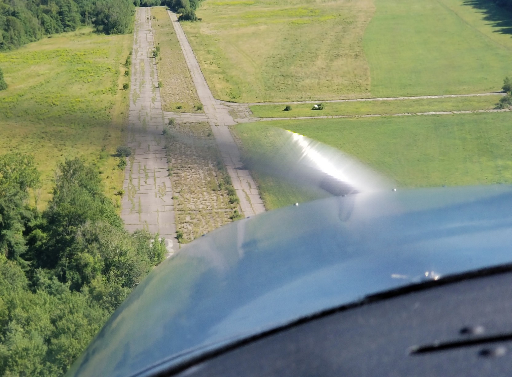
A 7/19/18 aerial view by Graeme Smith looking south along the remains of Norfolk Airport's former Runway 18.
Graeme reported, “Over the powerlines & a good slip over the trees & I could have easily put her down & stopped. Instead I did a go-around & departed.”

A 2019 photo by Ryan Berube of the granite memorial marker dedicating the “Heenan-Menfi Memorial Airport” in memory of 2 pilots who perished in a 7/12/91 crash.

A 2019 photo by Ryan Berube looking south along the former Norfolk Airport Runway 18.
Ryan observed, “You can see paint still on the runways, and for some reason, no closed [runway] yellow Xs.”

A 2019 photo by Ryan Berube at the site of Norfolk Airport, showing “ILS hold lines are still very clear”,
along with what appears to be some colorful post-airport graffiti.

A 2019 photo by Ryan Berube at the site of Norfolk Airport, showing “You can see where a taxiway led to a hangar, but the hangar was removed for houses.”

A 7/14/24 aerial view by Drew Lyons looking northeast at the remains of Norfolk Airport.
Drew observed, There are “a few large colonials built where the hangars used to be, but runway & taxiways still generally intact & the runway numbers are still visible.”
Thanks to Dan Fields for pointing out this airfield.
____________________________________________________
Or if you prefer to contact me directly concerning a contribution (for a mailing address to send a check),
please contact me at: paulandterryfreeman@gmail.com
If you enjoy this web site, please support it with a financial contribution.
____________________________________________________
This site covers airfields in all 50 states.