Abandoned & Little-Known Airfields:
Central New Jersey
© 2003, © 2026 by Paul Freeman. Revised 8/24/26.
This site covers airfields in all 50 states: Click here for the site's main menu.
____________________________________________________
Please consider a financial contribution to support the continued growth & operation of this site.
Lakehurst NAS (revised 11/20/23) - McGuire AFB BOMARC Missile Site (revised 9/22/24) - Preston Airport / Marlboro Airport (revised 8/24/26)
____________________________________________________
McGuire AFB BOMARC Missile Site, New Egypt, NJ
40.034, -74.441 (Southwest of New York, NY)
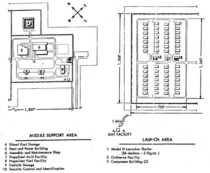
The layout McGuire BOMARC Missile Support Area & Launch Area,
from the 12/3/59 Boeing “IM-99A Bases Manual”,
showing the facility in its original configuration with 56 individual BOMARC A missile launch buildings.
Although not an airfield, the purpose of this military base was to shoot down incoming aircraft by launching huge Mach 4 antiaircraft missiles.
It is included here due to its significance in Cold War history, and its remarkable state of preservation.
This site was one of a network of 8 BOMARC sites spread around the nation.
The others were located at Dow AFB, ME, Suffolk AFB, NY, Otis AFB, MA, Langley AFB, VA,
Niagara Falls, NY, Kinchloe AFB, MI (Raco AAF), and Duluth IAP, MN.
Although designated the "McGuire AFB BOMARC site", the installation is well to the east of the Air Force Base.
It actually sits just off the end of the primary runway of the Lakehurst Naval Air Test Facility, just east of NJ Route 539.
The McGuire BOMARC installation was not yet depicted on a 1956 aerial photo or the 1957 USGS topo map.
The McGuire installation was the Air Force's first operational BOMARC missile installation.
Construction began in January 1958 & took nearly 2 years to complete.
The Philadelphia District of the Corps of Engineers supervised construction
of the 56 Model II shelters (each of which housed a single IM-99A BOMARC missile on a launcher) & ancillary buildings.
The site was declared operationally ready on 9/1/59, manned by the 46th Air Defense Missile Squadron.
The earliest depiction which has been located of the McGuire BOMARC installation
was a diagram of its Missile Support Area & Launch Area from the 12/3/59 Boeing “IM-99A Bases Manual”.
It depicted the facility in its original configuration with 56 individual BOMARC A “Model II Launcher Shelters”.
The Ground-to-Air Transmitter site which provided missile guidance was depicted one mile to the northwest.
However, according to the Air Defense Command historian,
the declaration of the McGuire BOMARC site's “operational readiness” in late 1959 severely strained the concept of the term.
As late as December, the facility hosted only 1 ready missile.

The earliest photo that has been located of the McGuire BOMARC site was a 5/2/60 USGS aerial view,
in its original configuration with 56 individual BOMARC A missile launch buildings along the north side of the installation.

A June 1960 aerial view looking north depicted the McGuire BOMARC site in its original configuration with 56 individual BOMARC A missile launch buildings along the north side of the installation.

An impressive 10/1/60 USAF photo of 4 BOMARC missiles elevated into launch position at McGuire.

An undated photo of a BOMARC launch. The BOMARC missile was huge: each one stood 45 feet tall & weighed 16,000 pounds.
More than 40 years after its deployment, it still holds the record for the longest range of any surface-to-air missile ever developed: 440 miles.
It also had a maximum speed of nearly Mach 4.
The McGuire BOMARC site was made infamous as the site of a radioactive material spill.
The incident happened on 7/7/60, according to the book “U.S. Nuclear Weapons: A Secret History”, by Chuck Hansen.
A nuclear-armed BOMARC missile in ready storage condition (permitting launch in 2 minutes) in missile Shelter 204
was destroyed by explosion & fire after a high pressure helium tank exploded & ruptured the missile's fuel tanks.
The warhead was also destroyed by the fire although the high explosive did not detonate.
Plutonium fragments from the warhead were spread over an area surrounding the launcher.
The firefighting efforts around the missile building resulted in contamination being washed into the soil & a nearby stream.
All identifiable fragments of the warhead were recovered,
but the surrounding soil in the site has remained in a low level radioactive state for over 40 years.

An undated photo of the remains of McGuire BOMARC missile Shelter 204, showing the damage caused by the 7/7/60 missile explosion.
By October 1962, McGuire's 1st generation BOMARC IM-99A missiles were superseded by the 2nd generation BOMARC IM-99B variant.
Rather than reconfigure the original Model II shelters to accept the new missile,
the Air Force directed that Model IV shelters be constructed on adjacent property to the north of the original launchers.
The New York District of the Corps of Engineers supervised the construction of these new launcher shelters.

A 1963 aerial view shows the addition of 28 individual BOMARC B missile launch buildings on the north side of the BOMARC A launchers.

The last photo which has been located showing the McGuire BOMARC site while still operational was a 2/24/70 USGS aerial view.

The McGuire AFB BOMARC missile site, as depicted on the 1971 USGS topo map.
With the reductions in US air defense forces, the McGuire BOMARC site was deactivated in 1972 along with all other BOMARC sites.
Andy Baumeister recalled, “We used to play in the abandoned BOMARC missile site.”
Of the site of the missile accident, he said “That area was covered in concrete & had another fence.
We stayed away from that. The rest of the place was fully intact minus the missiles.”

The McGuire AFB BOMARC missile site, as depicted on the 1989 USGS topo map.

A 1995 USGS aerial view looking northeast at the McGuire BOMARC site showed all 84 individual BOMARC missile launch buildings still existed.

A 2001 photo by Thomas Page of the entrance to the former missile annex.
The entrance to the launcher area is seen at the end of the road in the distance.

A 2001 photo by Thomas Page of the abandoned BOMARC A missile launch shelters.

A 2001 photo by Thomas Page of the abandoned BOMARC B missile launch shelters.

A 2001 photo by Thomas Page of a BOMARC A missile launch erector.

A 2001 photo by Thomas Page of a BOMARC B missile launch erector.

A 2001 photo by Thomas Page of the fenced-off area within the missile-launcher area.
This additional fence with rolls of razor wire inside strongly suggests that this is the area where the accidental fire occurred.
The next-to-last shelter on the right might have been the one that experienced the fire, as part of the shelter’s roof appears to be missing.
Out of all the BOMARC sites, the McGuire site is probably the one that remains in the best condition.
Most likely due to remaining low level radioactive contamination,
the entire site has simply been fenced off & abandoned as-is,
with little attempt made to dismantle & reuse any of the buildings or equipment.
As can be seen in the pictures, even the missile launch-erectors remain in the launcher buildings.
According to NJ resident Jim, as of 2002 the Air Force was finally decontaminating the site.
They have built roads through NAES Lakehurst & have extended a rail line onto the BOMARC site.
The contaminated soil is to be shipped by rail to a repository somewhere in the western US.

A 2002 photo (courtesy of Ed Drury) of Col. James Pugh, the Vice Commander of McGuire's 305th Air Mobility Wing,
in front of the former BOMARC missile shelters.
In 2002, the Air Force finally began a program to clean up the radioactive contamination of the BOMARC site.
A private contractor was hired to remove a total of 12,500 cubic yards of contaminated soil.
The project involved paving a 2.5 mile former tank trail which ran onto the Lakehurst NAS property,
to make it suitable for trucks carrying away the soil, and rebuilding a railroad spur on the Lakehurst property.

A 2005 aerial photo by Tom Kramer, looking east at the McGuire BOMARC site.
Tom observed, “A new fence has been erected completely around the facility as a company has been contracted to clean up the site.
You can see the light patch of ground where a few of the [launcher sheds] have been removed along with the earth.”

A 2014 photo by Ron Plante taken from outside the northern gate, looking at one of the McGuire BOMARC-B launcher shelters.
Ron reported, “It’s my guess the northern gate was added to handle all the heavy construction equipment when they added the 28 additional B shelters.”

A 2016 aerial view looking northeast at the McGuire BOMARC missile launch site.
The McGuire BOMARC site is located along Route 539.
See also: http://www.radomes.org/acwrons/recent/McGuireAFBBOMARCNJ.html
____________________________________________________
Lakehurst Naval Air Station (NEL), Lakehurst, NJ
40.03, -74.35 (East of Philadelphia, PA)

A circa 1920-21 photo of Lakehurst Hangar #1 while under construction (from the Irwin & Leighton archives, courtesy of Cindy Hodgson).
The Lakehurst base had a curious start in 1915 as an ammunition proving ground for the Russian Imperial Government & then the US Army Chemical Warfare Service.
It served in this capacity until 1921, at which point it was commissioned by the US Navy as a Naval Air Station.
The Navy's aerial facilities at Lakehurst would eventually come to comprise 3 distinct airfields, with a total of 6 large hangars.
The original Lakehurst airfield is located on the eastern side of the base.
The 1st hangar at the Lakehurst east airfield was known as Hangar 1.
It was based on the typical designs of World War I airship hangars.
It resembled many of the rigid airship hangars built in Great Britain
which used counter-balanced doors in lieu of the steel supporting framework generally found in German hangar design.
The construction contract for Hangar 1 was awarded to the Lord Construction Company on 9/8/19.
The first of 10 trusses were erected by the Bethlehem Steel Company on 5/8/20.
The hangar consisted of 3 pinned, arched steel trusses supported on steel towers.
The outer columns & chords supported the side wall framing & siding.
Shops, offices and service areas with mezzanines were located on each side along the entire length of the hangar.
The steel structure was lightweight rolled sections joined by riveted gusset plates.
Hangar 1's trusswork supported catwalks on several levels along each side, across the end arches & along the centerline of the ceiling.
Siding & roofing were corrugated cement & asbestos panels
in 2 different shades of brown & one shade of gray for camouflage purposes, which proved a checkerboard effect.
Construction was completed on Hangar 1 in 1921, at a cost of $4 million.
It had exterior dimensions of 966' long, 350' wide, and 224' high, and had a total of 211,434 square feet of interior area.
The earliest depiction which has been located of the Lakehurst airfield
was a circa 1920-21 photo of Lakehurst Hangar #1 while under construction (from the Irwin & Leighton archives, courtesy of Cindy Hodgson).
According to Cindy Hodgson, Irwin & Leighton was the firm that built the original Lakehurst hangar.
The 2-leaf sliding, counterbalanced doors at each end of the hangar were massive;
each door leaf weighed 1,350 tons & measured 136' wide, 177' high, and 76' deep at the base.
The hangar was designed to be as safe as possible, considering the use of hydrogen.
The floor was spark-proof, and electrical panels & lighting were explosion-proof.
Adjacent to the hangar were facilities for helium purification.
A helium storage tank, or gasometer, was located north of Hangar 1.
Helium was piped directly into the hangar in sealed piping.
Although hydrogen was not used for the Navy rigid airships,
it was made available to the German Zeppelins from railroad tank cars.
Hangar 1 originally included a system of trolley tracks serving as docking rails for airship handling.
These rails ran through the hangar & 1,500 feet from each end onto the landing areas.
With developments in rigid airship handling, the track system was revised
and the tracks through the hangar ran to a hauling-up or docking / undocking circle to the front (west) of the hangar.
A system of tracks led to 2 mooring-out circles for trolley masts,
the stern beams & riding-out cars for mechanical handling of rigid airships.

A 9/4/23 photo of the rigid airship USS Shenandoah (ZR-1) leaving Lakehurst Hangar #1 (probably for the very 1st time).
According to Alan Reddig, “On the evening of 1/16/24, while the airship USS Shenandoah was tethered to the mast at Lakehurst, a gale torn it loose, leaving parts of its nose structure dangling from the mast.
My crazy-about-aviation father, James Reddig, who was then in his junior year in high school in East Orange, somehow convinced his father to drive him to Lakehurst, 50 miles distant, to see what all the excitement was about.
As my father described it, when they arrived 'Everyone had gone thataway over the horizon', chasing after the airship (which was safely brought back the following day).
In their absence, he scampered up the mast and retrieved a piece of aluminum x-bracing from among the airship’s debris.”

An undated photo of the rigid airship USS Shenandoah inside a Lakehurst hangar, showing the damage received during the storm of 1/16/24 (courtesy of Alan Reddig).

A 10/15/24 photo (courtesy of Gary Fitton) of the airship USS Los Angeles ZR-3 at NAS Lakehurst.
According to Gary Fitton, the photo is “what I believe to be the delivery flight of the ZR-3 to NAS Lakehurst.
Found in my Grandfather’s house in Lakewood NJ in the late 1940s.”

An amazing 8/25/27 photo of the USS Los Angeles ZR-3
after her tail rose out-of-control to 85 degrees while she was moored at the Lakehurst high mast.
This incident resulted from the sudden arrival of a cold air front that lifted the airship's tail,
causing it to rise before she could swing around the mast parallel to the new wind direction.
The USS Los Angeles suffered only minor damage, but the affair demonstrated the risks involved with high mooring masts.

A November 1928 photo looking west at the mooring mast in front of Lakehurst Hangar #1.

The earliest map depiction which has been located of the Lakehurst airfield
was on the 1930 "Rand McNally Standard Map of NJ With AirTrails" (courtesy of Chris Kennedy).
Lakehurst was the consummate rigid airship station.
Hangar 1 often housed 2 rigid airships & 3 or 4 of the smaller non-rigid airships.
When 2 rigid airships occupied the hangar, it became overcrowded,
particularly with the relatively low & wide, but long (186') stern beam for securing the lower fin.
In 1931, due to this overcrowding, Lakehurst's non-rigid airships were transferred temporarily to Cape May, NJ.

Lakehurst NAS, as depicted on the May 1932 J-18 Washington D. C. Airway Map (courtesy of Chris Kennedy).
At one time or another, Hangar 1 housed every active American rigid airship (Shenandoah, Los Angeles, Akron and Macon),
the Graf Zeppelin & Hindenburg, several Army airships (including the semi-rigid airship, RS-1 in July 1927)
and every type of non-rigid airship constructed for the Navy from 1922-60.
Hangar 1 housed the Navy's last rigid airship (USS Los Angeles), which made its last flight 6/26/32.
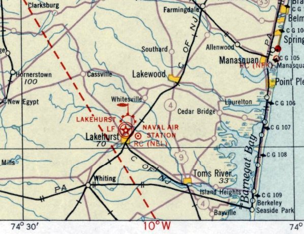
The earliest Sectional Chart depiction which has been located of Lakehurst NAS was on the August 1932 NY Sectional Chart.
It depicted 2 different airfields, and a blimp mooring mast.

A circa early-1930s aerial view of the Lakehurst “U.S. Navel [sic] Air Station”
depicted the field as having 3 blimp mooring circles, with Hangar 1 in the center of the photo.
What was eventually known as Hangar 4 was visible on the east side.
There did not yet appear to be any runways at the facility.
The 1934 Department of Commerce Airport Directory (according to Chris Kennedy)
described Lakehurst NAS as having three 1,200' sand runways arranged in a triangle.

A remarkable 5/9/36 USCG aerial view (courtesy of Ron Plante) looking west at the Zeppelin LZ 129 Hindenburg's arrival at Lakehurst after its inaugural flight from Friedrichshafen, Germany,
being escorted by a Coast Guard Douglas RD-4 Spica (s/n V-125).
The decommissioned U.S. Navy airship USS Los Angeles (ZR-3) is visible in the background.
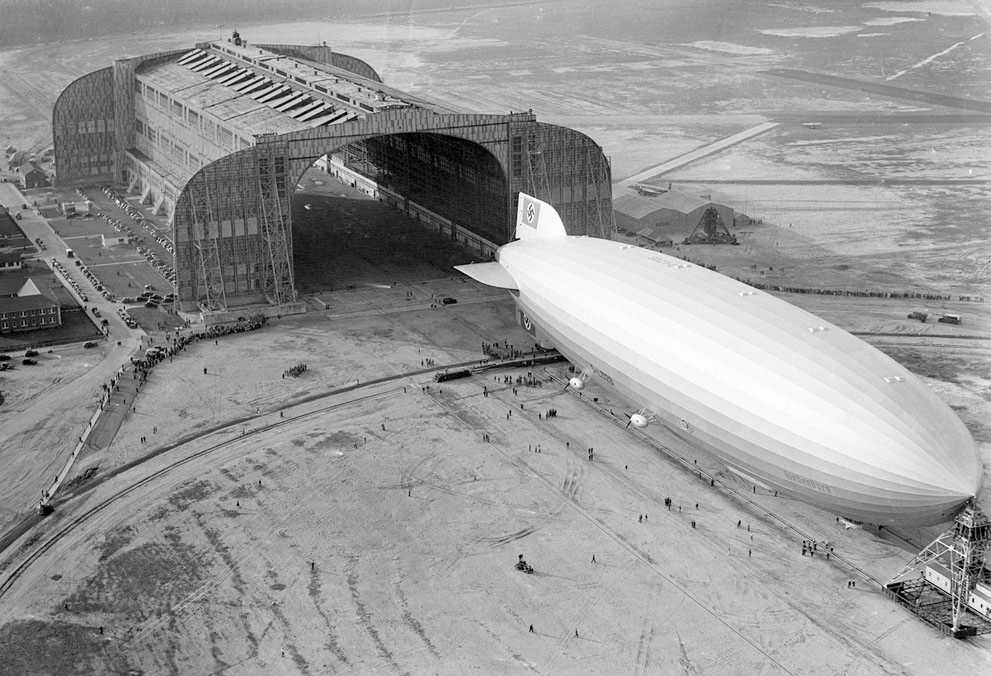
A 5/9/36 aerial view (courtesy of Ron Plante) of the Hindenburg being maneuvered into the Lakehurst hangar, its nose hooked to the mobile mooring tower.
The rigid airship had just set a record for its first north Atlantic crossing, the first leg of 10 scheduled round trips between Germany & America.

The only time the Hindenburg was housed inside Lakehurst's Hangar 1 in 1936 (National Archives photo).
The Hindenburg just fit within the hangar, with 18 inch clearance on the bow & stern.

A July 1936 photo of the 2nd Douglas DC-3 (American Airlines NC16001) in front of Zeppelin LZ 129 Hindenburg at Lakehurst.

A remarkable 8/9/36 photo of the Hindenburg inside a Lakehurst hangar, dwarfing the Navy ZMC-2 blimp also inside.

A circa 1936-37 photo of the Hindenburg in front of Lakehurst Hangar 1.
The Airport Directory Company's 1937 Airports Directory (courtesy of Bob Rambo)
described NAS Lakehurst as having 3 runways, including a 1,200' east/west concrete runway,
a mooring mast to the northwest, and a hangar to the east.

Lakehurst became infamous on 5/6/37 as the site of the Hindenburg dirigible disaster.

A 5/7/37 aerial view (courtesy of Ron Plante) of the wreckage of the Hindenburg airship in front of the Lakehurst hangar.

A 10/25/37 aerial view of NAS Lakehurst's Hangar 1 & adjacent runways (from the Philadelphia National Archives, courtesy of Ron Plante).
Hangar 1 was the subject of mooring tests as late as 1937.
To house larger rigid airships, it was once proposed that the sliding doors be replaced
with the orange-peel or clam-shell type doors of the Goodyear-Zeppelin design.
This change would have provided additional length at each end of the hangar.

A 6/30/38 map of NAS Lakehurst (from the College Park National Archives, courtesy of Ron Plante)
depicted the 3 runways of Lakehurst East Field, as well as the first runway of West Field (Maxwell Field).

A 12/18/39 aerial view of a blimp over NAS Lakehurst, with Hangar 1 visible at right (from the Philadelphia National Archives, courtesy of Ron Plante).

A late-1930s or early-1940s aerial view looking east at NAS Lakehurst (National Archives photo).
Hangar 4 was visible in the top-left, with Hangar 1 below it.
A set of 3 paved runways had been added just south of Hangar 1.
USS Los Angeles was completely dismantled & removed from Hangar 1 by January 1940.
After 1940, the hangar was used exclusively for non-rigid airships.
Hangar 1 provided sufficient space for all of the Navy's non-rigid airships after January 1940 until 1942.

Ron Plante found this 7/2/40 photo of Lakehurst's Hangar 1 at the National Archives in Philadelphia.
Ron reported in 2016, "This is the same view you'll get today after entering the NAS thru the main gate.
The 1,350 ton back (east) doors you see have not been used in many years the museum people tell me the front doors are opened once a week.
The brick building in the right foreground is still there, and the museum entrance is just past that structure."
Due to changes over the years, only Hangar 1's west doors have been used since the time of the USS Los Angeles,
except during World War II field construction in 1942.

The November 1942 NY Sectional Chart (courtesy of Ron Plante) depicted NAS Lakehurst as having a blimp mooring mast.

A 6/21/46 aerial view by Don Reid looking west at Lakehurst's Hangar 1, taken from the nose of the K-24 Navy Blimp (courtesy of Bruce Reid).
Bruce Reid observed, “Note the handling lines hanging down from the nose”, coming down from the top of the photo.

The 1948 USGS topo map depicted Lakehurst as having 3 paved runways, with 3 hangars to the northeast,
along with 2 circular blimp mooring fields.

The 1948 USGS topo map depicted Lakehurst's Hangars 1-6.
It depicted the east field as having 3 paved runways, with the longest being 3,800'.
A huge circular “Landing Field” was also depicted to the northwest.

The only airfield at Lakehurst which was depicted on the 1949 NY Sectional Chart (courtesy of Chris Kennedy)
was the original airfield, on the eastern side of the base.
NAS Lakehurst was described as having a 3,800' hard-surface runway.

An April 1949 – October 1955 photo of Kaman K-190B N74148 C/n 3 & a Sikorsky in front of the Lakehurst hangars.
All 3 runways of NAS Lakehurst-East had prominent closed-runway “X” markings on each end on a 1956 aerial view.
Mark Childers recalled, “The old man [his father] loved everything about Hangar One -
from the design to the interior appointments (lots of bosun's mates fancy ropework, and perfectly polished brass)
to the miniature train that opened the doors, and the fact that with the doors closed, it could generate its own weather.
For the last few years of his mostly GS-13 Civil Service career, he took a spot with the Hangar One maintenance crew & absolutely loved keeping the place up.
Whenever he worked night shift & had to walk the roof to check on the hundreds of lights,
I made it a point to drive out to the base - sometimes with my girlfriend - and walk it with him. The view was astounding.”

A circa 1960s photo (courtesy of Mark Childers) of a Douglas A-4 Skyhawk & 3 Beech T-34 Mentors on the quarter-scale carrier flight deck inside Lakehurst Hangar 1.
Mark Childers recalled, “Over the years it had an A-4 Skyhawk, and several early & late versions of the little T-34 Mentor.
The 90' T-29 Flying Classroom, with 100' wingspan was a virtual clone of the old Navy/AF C-131 Samaritan transport.”

The 1960 Jeppesen Airway Manual (courtesy of Chris Kennedy)
depicted the Lakehurst NAS West Field as having two 5,000' paved runways (6/24 & 15/33).
The 3 runways of the East Field were still depicted,
but it was noted as being "Closed to fixed wing aircraft."

The January 1961 NY World Aeronautical Chart (courtesy of Scott Kimball) depicted all 3 Lakehurst airfields.
Hangar 1 was designated a Registered National Historic Landmark in 1968.
All 3 runways of NAS Lakehurst-East had prominent closed-runway “X” markings on each end on a 1963 aerial view.
What appeared to be a large circular blimp mooring pad was constructed
adjacent to the west side of Lakehurst-East's northeast/southwest runway at some point between 1956-63.
However, NAS Lakehurst-East was still depicted as an active airfield
on the 1969 Washington Sectional Chart (courtesy of Chris Kennedy).

A 1969 photo by George Baczkowski of a Blue Angels F11F-1 Tiger mounted on a pylon by a side gate, with blimp hangars visible in the background.
Michael Capp recalled, “NAS Lakehurst... I was stationed there in the 1960s & 1970s.
The mooring field described above the test facility was used for many years as the Navy Parachute Rigger’s parachute drop zone
(I personally have about 78 jumps into that circle both solo & as an instructor with students).
The circle was also used to test explosive blade bolts for Cobra helicopter ejection/escape systems, and more.
The Naval Air Technical Training Center (NATTC) had schools located at Lakehurst through the 1960s-1980s.
Schools included the Aviations Bosons Mate schools, Navy Weather School, Parachute Rigger School,
and the Marine Corps SATS (Short Air Tactical Strips) school.
The aircraft carrier built inside Hangar 1 was built to accommodate the AB school.
Lakehurst had the only Helium plant on the east coast. It is still located just down the hill from Hangar 1.
The building we taught PR school in was originally built to fabricate & repair airships (both dirigible & balloon),
and had markings in the floor (like a basketball court) that were the templates for airship fabric sections.”

On the 1970 Washington Sectional Chart (courtesy of John Clifford),
NAS Lakehurst East had been downgraded to a heliport.

A May 1971 photo of N15696, a 1936 Bucker Bu-133B Jungmeister, serial #42 at Lakehurst.

A 7/4/76 photo of BuNo 146698, a beautiful North American RA-5C Vigilante, serial #NA296-47, at Lakehurst.

An undated aerial view looking north at Lakehurst NAF from the 1979 NJ Airport Directory.
It described Lakehurst as having two 5,000' asphalt runways: 6/24 & 15/33.
At some point between 1970-91, the Lakehurst East airfield was closed as an aviation facility altogether,
as it was no longer depicted at all on the 1991 Washington Sectional Chart (courtesy of Mike Keefe).
According to Captain Ray Lewis (who went to school in Lakehurst at Hangar 1 in early 1973),
Hangar 1 is "a very unique building & deceptively large.
In fact there is a 1/4 scale carrier flight deck in the Northeast corner of the hangar
that has a working T-29 that we use to direct around for practice on a flight deck.
You have to look hard not to overlook the flight deck - it's that big inside the hangar.
Very cold in the winter & very hot in the summer."
One of the most unusual aircraft ever to fly from Lakehurst was the Piasecki PA-97 Heli-stat.
The Heli-stat had been built under a 1980 U.S. Navy contract for the Forest Service
to demonstrate economic & ecological potential of heavy vertical air lifters
in harvesting timber & other natural resources in difficult-to-get-to terrain.
The demonstration vehicle utilized a Navy ZPG-2W aerostat (with a 1-million cubic-foot envelope)
and 4 surplus Sikorsky H-34J helicopters.
Inflating the aerostat envelope with helium to its length of 343 feet
made the Heli-Stat the largest aircraft in the world (longer than the span of the Hughes flying boat).
The first free hovering flight of the Piasecki PA-97 Heli-stat was made at Lakehurst on 4/26/86.
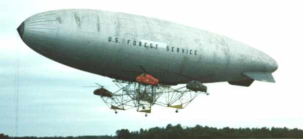
A 1986 photo of the Piasecki PA-97 Heli-Stat hybrid vertical heavy lifter hovering over Lakehurst.
On 7/1/86 the Helistat had just completed a test flight successfully & landed at Lakehurst.
A power loss was noted on the #3 helicopter & the test was terminated & the mooring mast called for.
Prior to re-mooring a wind shift caused an uncommanded left turn which the pilot could not counteract with the flight controls.
With a tailwind, no wheel brakes or ground steering a takeoff was attempted.
The 4 main landing gear which had no shimmy dampers started to shimmy.
The 4 helicopters started to react to the shimmy with ground resonance.
As the Helistat finally lifted off, the 4 individual helicopters broke off & fell to the ground.
One pilot was killed, 3 received serious injuries, one received minor injuries, and the Helistat was destroyed.
The power loss on the #3 helicopter was traced to a missing throttle linkage correlation pin.

A circa 1990s aerial view looking northwest at the Lakehurst complex,
with Maxfield Field at the left, Hangars 5 & 6 in the center, and Hangars 1-3 at the right.
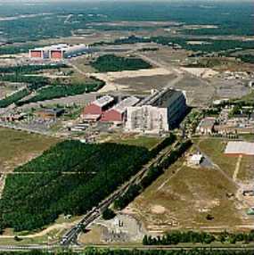
A circa 1990s aerial view looking northwest at Lakehurst, with Hangars 1-3 in the center, and Hangars 5 & 6 at the upper left.
Bruce Reid recalled, “I spent my entire 37 year Civil Service career at NAS Lakehurst.
That 7,400 acre site had morphed into many entities from 1921.
I started work there at Naval Air Test Facility in 1959, and worked at the 5 track sites, RALS site, Catapults, West Field (Max Field),
Hangars 1, 5 & 6 as well as both Engineering buildings for Integrated Logistics Support for Naval & Marine Corps Aircraft Systems. I retired 1995.”

A circa 1990s photo of historic blimp Hangar 1.

In the 1997 USGS aerial photo of the original Lakehurst East airfield,
all 3 paved runways were marked with closed "X" symbols.
The longest of the runways was 4,200'.
As of the late 1990s, the CALASSES (Carrier Aircraft Launch & Support Systems Equipment Simulator)
was located in Hangar 1.
It is a 1/4th scale model carrier deck used for training Navy aircraft operators.

A circa 2006 aerial view looking east at Hangars 1, 2, and 3.
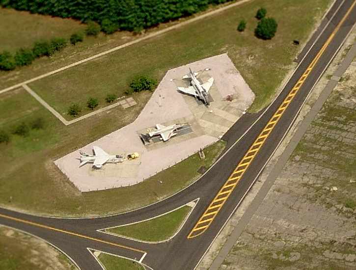
A circa 2006 aerial view looking east at a static display located just north of Hangar 1
of an A-7 Corsair, A-4 Skyhawk, and F-4 Phantom.

A March 2014 photo by Ron Plante of the memorial commemorating the site of the Hindenburg disaster.

A March 2014 photo by Ron Plante looking east at Lakehurst's Hangars 1-3.

A March 2014 closeup by Ron Plante looking northeast at the west side of Lakehurst's Hangars 1 & 2.
Ron Plante reported in 2014, “I saw 2 Short Skyvans that did not appear flyable, plus there was a UH-60 in Army green parked in front of the Maxfield tower.”

A 5/5/15 photo by Tekang Wang of Lakehurst's “Hangars 1, 2 and 3 from the memorial at the center of the field.”
Note the A-7 Corsair, A-4 Skyhawk, and one other aircraft to the left of the hangars.

A 5/5/15 photo by Tekang Wang of of the historical plaque at the site of the Lakehurst Hindenburg disaster.

A 5/5/15 photo by Tekang Wang at Lakehurst “of some preparations for the anniversary ceremony which was to occur the next day at the site of the Hindenburg disaster.”
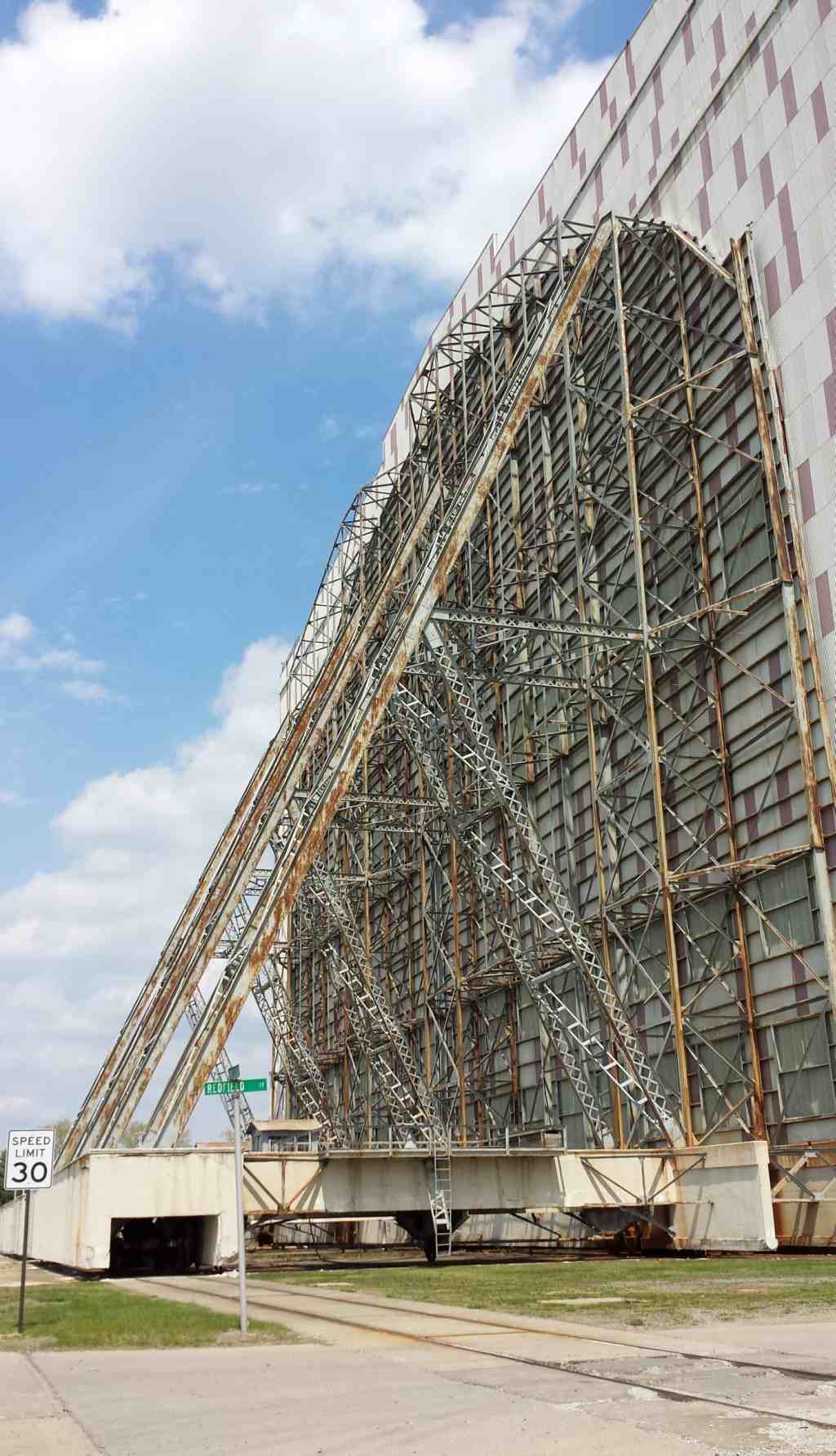
A 5/5/15 photo by Tekang Wang at Lakehurst “of the massive doors at Hangar 1.
The door operating mechanics appeared complete & in fair condition although rusty, as were rails that the doors ride on.”

A 2016 aerial photo of the original Lakehurst East airfield, showing the remains of its 3 runways & its still-standing blimp hangars.

A 2018 3-D aerial view looking southeast at Lakehurst Hangars 1-3.
...........................................................................................................................................................
Lakehurst's Hangar 4 was a World War I hangar relocated from Norfolk, VA.
The hangar was dismantled at Norfolk in 1931 & erection at Lakehurst was completed in early 1932,
northeast of Hangar 1 near the station's east boundary road.
Hangar 4's construction was steel with exterior doors at the west end only.
It had an exterior length of 253' long by 152' wide by 97' high,
and had an interior measuring 33,500 square feet.
Railroad tracks ran from Hangar 1 to Hangar 4.
Hangar 4 was known as the non-rigid hangar
because it was erected for non-rigid airships to alleviate crowding when 2 rigid airship occupied Hangar 1.
After completion, Hangar 4 was used at various times by the airships J-3, J-4, K-1, ZMC-2, G-1, L-1, TC-13 and TC-14.
The hangar was frequently used when 2 rigid airships with railroad masts & stern beams were housed in Hangar 1.
Due to the limited height of Hangar 4, only the smaller, older non-rigid airships could use Hangar 4.
The K-2 airship, the first modern patrol airship constructed in 1938, could only use Hangar 4 if the top fin were removed.
Hangar 4 was used by airships until January 1940.
During World War II, Hangar 4 was occasionally used by airships,
but was used primarily for the free balloons used in training.

A circa 2006 aerial view looking east at Hangar 4.
Since WW2 the main use of Hangar 4 has been for storage, recently for surplus property.
Joe Panzarino reported in 2009, “Hangar #4 at Lakehurst is the last remaining WW 1 blimp hangar still in existence today.”

A 2018 3-D aerial view looking northeast at Lakehurst Hangar 4.
...................................................................................................................................
As part of the pre-WW2 6-airship construction program,
Lakehurst's Hangars 2 & 3 (with bypassing sliding doors) were begun.
Hangars 2 & 3 were erected by the Duffy Construction Company of New York City
and were built adjacent to the southwest side of Hangar 1.
Hangar 2 was the 1st airship hangar to be erected for the Navy since the Moffett Field hangar in 1933
and was intended as an overhaul & fitting-out facility.
Construction was started on 6/24/41 & was completed on 5/13/42.
Hangar 2 had exterior dimensions of 614' long, 217' wide, and 118' high, and had 93,620 square feet of interior space.
Hangar 3 was designated for the use of training airships & was started on 8/1/41 & completed on 6/30/42.
Hangar 3 had exterior dimensions of 414' long, 217' wide, and 118' high, and had 62,650 square feet of interior space.
Hangars 2 & 3 were used in the post-WW2 period to house antisubmarine warfare helicopter squadrons.
.......................................................................................................................................................................................
Lakehurst's Hangars 5 & 6 were authorized on 6/3/42, to be located in the center of the Lakehurst base.
They were built to an identical WW2 design, made of wood due to the wartime scarcity of steel.
Hangars 5 & 6 were erected by joint general contractors Karno-Smith Company of Trenton, NJ
and Duffy Construction Company of New York City,
with the Phoenix Bridge Company brought in to erect the arches.
The track-mounted triangular travelers used to erect the arches had been used previously
in the construction of the George Washington Bridge over the Hudson River at New York City.
Truss members were precut on the west coast by Timber Structures, Inc.,
shipped in specially heated railroad cars & fire-proofed in transit.
There were only a few problems during the hangars' construction;
namely finding sufficient labor because industries in the New York City & Philadelphia areas had absorbed manpower.
This necessitated recruiting labor in other areas.
The airship training that was in progress at Lakehurst during the time also complicated the construction work.
Construction on Hangar 5 was completed on 7/1/43, and Hangar 6 was completed on 8/15/43.
Once completed, Hangars 5 & 6 were the largest single-arch structures in the world.
They had exterior dimensions of 1,086' long, 297' wide, and 183' high, and had a total of 241,110 square feet of interior area.

A circa 1990s aerial view looking southeast at Hangars 5 & 6.
According to Army Aviator Tom Kahlert, “The Hueys & Beech twins were active Army Flight Detachment assets which supported VIP & laboratory requirements at Ft Monmouth before all were disbanded.”

A still from a circa 2004 video of the ISL Bosch Airborne Communication Extender airship inside Lakehurst Hangar #5 or #6 (courtesy of Pete Lobner).

A still from a circa 2004 video of the ISL Bosch Airborne Communication Extender airship being towed out of Lakehurst Hangar #5 or #6 (courtesy of Pete Lobner).

A still from a circa 2004 video of the ISL Bosch Airborne Communication Extender airship in front of Lakehurst Hangars #5 & #6 (courtesy of Pete Lobner).

A still from a circa 2004 video of the ISL Bosch Airborne Communication Extender airship flying in front of Lakehurst Hangars #5 & #6 (courtesy of Pete Lobner).

A circa 2006 aerial view looking east at Hangars 5 & 6.

A circa 2006 aerial view looking east at what appeared to be the only active aircraft on the entire Lakehurst airfield complex:
two Shorts C-23 Sherpa light transports, parked on the ramp just northwest of Hangars 5 & 6.

A 2018 3-D aerial view looking southeast at Lakehurst Hangars 5 & 6.
......................................................................................................................................................

A 1956 aerial view depicted Maxfield Field as having 2 paved runways.
Maxfield Field (in the center of the base) was built at some point between 1951-56.
The earliest depiction of the field which has been located was a 1956 aerial view .

A closeup from the 1956 aerial view depicted the ramp on the east side of Maxfield Field as having 2 R4D transports
and a large number of single-engine aircraft, some being carrier-based planes with folded wings.
The earliest aeronautical chart depiction of Maxfield Field which has been located
was on the 1957 NY Sectional Chart (courtesy of Mike Keefe).
It depicted NAS Lakehurst West as having a 5,000' hard-surface runway.

The 1958 NY Sectional Chart (courtesy of Chris Kennedy)
depicted NAS Lakehurst West & NAS Lakehurst East.
A 1963 aerial view showed that a hangar had been built just east of Maxfield Field's runway intersection at some point between 1956-63.

The 1997 USGS aerial photo of Maxfield Field, hangars, and several circular blimp mooring circles.
As of 2003, Maxfield Field was still operated as an active air facility, with two 5,000' runways.
Douglas Wright reported in 2004 that Lakehurst is receiving a new or upgraded 6,500' runway
to support assault landing training by the C-17s which are being assigned to nearby McGuire AFB.
It is not known where on the Lakehurst complex this runway will be located -
whether it will be an entirely new runway or an upgrade of one of Maxfield Field's existing runways.
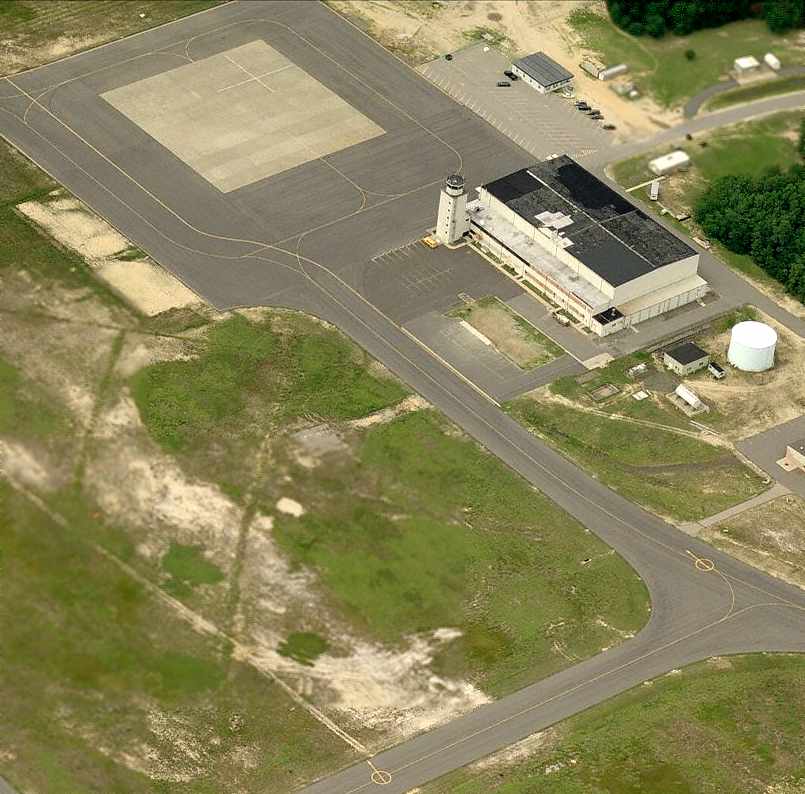
A circa 2006 aerial view looking north at the post-WW2 fixed-wing aircraft hangar & control tower on the east side of Maxfield Field.
Douglas Wright reported in 2010 that Lakehurst's new assault strip “is now a reality.”
It is a 3,500' paved runway parallel to Runway 6/24 on the northwest side.

A 2016 aerial view of Maxfield Field & its blimp hangars.

The 2016 NY Sectional Chart depicted Lakehurst Maxfield Field as having 3 paved runways.
......................................................................................................................................................
The Naval Air Test Facility (on the west side of the Lakehurst base) consists of 2 very large facilities:
a set of 5 tests tracks on the north side, and the NATF runway to the south.
A 1956 aerial view showed the beginnings of the NATF facilities, with the 1st test track (the northern one) having been built.
A 1963 aerial view showed that all 5 test tracks had been completed at some point between 1956-63.

The 1997 USGS aerial photo of the NATF runway, catapult sled test tracks,
and the circular blimp mooring field to the northeast.
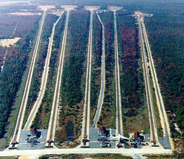
As described on Lakehurst's web site in 2003, the 5 test tracks are up to 9,150' long.
A sled propelled by 4 J-48 jet engines (developing a total of 42,000 lbs of thrust)
is used to propel weighted deadloads (up to 100,000 lbs) or airframes
down the track (at speed up to 250 knots) into the arresting gear or barricade under test.
The remote location provides a safety & noise buffer. Runaway deadloads have harmlessly wandered off into the woods.
The site has been used by the Air Forces, FAA and foreign governments.
The primary Navy use is wire rope acceptance tests, barricade testing, and arresting gear evaluation & verification.

A circa 1980s/90s photo of the Lakehurst test track, with an F/A-18 airframe mounted on the jet-propelled sled.
......................................................................................................................................................
The NATF runway was built to conduct aircraft carrier catapult & arresting gear tests,
with a catapult & arresting gear built into the runway.
A 1956 aerial view showed the beginnings of the NATF facilities,
with the only the western end of the NATF runway having been constructed.
Mark Childers recalled, “I spent a good deal of my late 1950s / early 1960s childhood Saturdays roaming around NAS Lakehurst.
I barely remember what was for lunch today, but can close my eyes & visualize the base in the 1950s & 60s (always a horrible car wreck on static display to remind sailors to drive safely),
the main gate & administration just off Hope Chapel Road, the blimps, helos, all of the hangars, the hobby shop, commissary, exchange, and the O & EM clubs.”
Mark continued, “For many years, my dad, a retired Army Officer, worked at the Naval Air Ship Installation Test Facility way out on the west end of the base not far from the rocket sleds.
The test center had a 10,000' runway & a bunch of warehouses & workspaces that would have made the set of Mythbusters pale by comparison.
When I did a science project I had free run of the warehouse & a veritable corps of engineers who tried to outdo each other.
Dad was sometimes called over to the 'CAT-5' area which housed the rocket sleds.
I got to see quite a few absolutely breathtaking rocket shots when he worked the 4-midnight shift at NATF -
I would go to work with him at night to witness many dramatic live aircraft tests including a couple that literally revolutionized carrier aviation.”
A 1963 aerial view showed that the entire length of the NATF runway had been completed at some point between 1956-63.
The earliest aeronautical chart depiction of the NATF runway which has been located
was on the 1960 Washington Sectional Chart (courtesy of Mike Keefe).
It depicted NATF Lakehurst as having a single 7,600' paved runway.

The 1962 Washington Sectional Chart (courtesy of Chris Kennedy)
depicted NATF Lakehurst as a single 7,600' runway, NAS Lakehurst West as 2 runways (longest 5,000'),
and NAS Lakehurst East as 3 runways (longest 3,800').
Within the next 2 years, the NATF runway was extended to its ultimate length of 11,600',
as that is how it was depicted on the 1964 Washington Sectional Chart (courtesy of Chris Kennedy).

A circa 1980s/90s photo of the Lakehurst NATF runway.
The NATF runway was still depicted as an active airfield
on the 2000 Washington Sectional Chart (courtesy of Chris Kennedy).
The Naval Air Test Facility was evidently closed at some point between 2000-2001,
as it was no longer depicted at all on the 2001 Washington Sectional Chart (courtesy of Chris Kennedy).
Given that the runway is over 11,000 feet long,
it would have seemed reasonable to still depict it on the chart as an abandoned airfield,
both for landmark value & for possible emergency use.
However, although it is no longer listed as an active airfield,
the NATF runway was still described on Lakehurst's web site in 2003.
The 3 components of the NATF runway complex are the Catapult Test Site,
the Runway Arrested Landing Site, and the Jet Blast Deflector Site.

A circa 1980s/90s photo of an F/A-18 on the Lakehurst catapult.
The Catapult Test Site has 2 catapults: the TC13 Mod 0 & TC13 Mod 2.
Both catapults can launch aircraft or deadloads up to 100,000 lbs with speeds up to 185 kts.
This is the only facility in the world with deadload launch capability.
The TC13 Mod 2, developed at Lakehurst, will save the Navy up to $1/2 billion per ship over the life cycle.
The lower pressure demands from the ship's reactor lengthens the time necessary between reactor recoring.
The site steam plant can produce up to 138,000 lbs per hour.
The site has been used to conduct tests for the Army, Air Force, NASA,
and private industry (McDonnell-Douglas, U.S. Rubber).

A circa 1980s/90s photo of an S-3 Viking catching a wire on the Lakehurst arresting gear.
The Runway Arrested Landing Site is the only site in the world that allows
high-speed roll-in & fly-in arrestments on shipboard & landbase arresting gear.
It provides over 3,000' prior to arrestment & an 8,000' safety buffer after arrestment.

A circa 1980s/90s photo of an F-14 & F/A-18 being tested with the Lakehurst Jet blast deflector.
The Jet Blast Deflector Site is the only site in the world that can conduct aircraft acceptance tests
that demonstrate compatibility with the JBD.

A 2005 aerial photo by Tom Kramer, looking east.
The photo captures in one view a remarkable array of historical airfield infrastructure,
including the NATF runway in the right-foreground,
the 4 catapult test tracks behind it to the left, the blimp mooring circle, the 2 perpendicular runways of Maxfield Field,
and the giant pair of blimp Hangars 5 & 6 in the background.
Douglas Wright reported in 2010, “The NAEC has added a magnetic catapult which they are testing.”

A 6/25/11 aerial view of a new Lockheed F-35C Lightning II arriving at Lakehurst for carrier testing, with the Lakehurst NATF runway visible in the background.

A 10/15/11 USAF aerial view looking east by Ryan Throneberry of a Marine AH-1W Super Cobra helicopter of Light Attack Helicopter Squadron 773,
with almost all of the historic Lakehurst aviation infrastructure visible in one photo.
The Super Cobra was providing support during a Joint Tactical Recovery of Aircraft and Personnel exercise,
which tested the Reservists’ ability to recover downed aircrews behind enemy lines.

A 2016 aerial view of the Lakehurst NATF runway, the catapult sled test tracks north of the runway, and the circular blimp mooring field to the northeast.
____________________________________________________
Preston Airport / Marlboro Airport (2N8), Marlboro, NJ
40.366, -74.253 (Southwest of New York, NY)
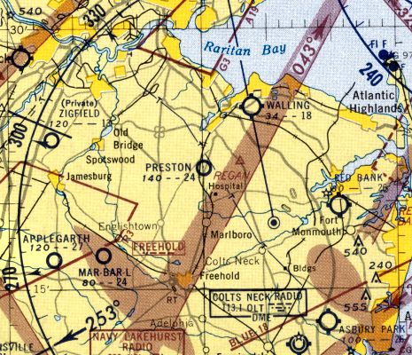
Preston Airport, as depicted on the January 1955 NY Sectional Chart.
Preston Airport is yet another one of a staggering number of general aviation airports which have closed in the last few decades in NJ.
Preston Airport was not yet depicted on the January 1953 NY Sectional Chart or a 1953 aerial photo.
Flight enthusiast Rhea Preston was granted permits in 1954 to operate an airport on his farm.
A grass runway was laid out along a flat portion of Preston's farm, according to the book "Images of America: Marlboro Township".
Candee Preston recalled, “Preston Airport... It was my dad, Rhea Preston, who began the whole operation in 1954.
When they closed [Hazlet Airport] to put up the shopping center, is when my dad opened Preston.
I have the original state license given to my dad for the airport. It is an interesting story how he achieved that feat.
He went to Marlboro Township officials one day & asked if there were any restrictions on an airport in town.
When they said, no, he drove to Trenton, filed the paperwork, and was issued the license.
Needless to say, some people in town weren't too pleased. The gas tanks at Preston were installed on my brother's birthday, 5/30/55.
It was a hobby for my dad, but provided him with his love of flying & a little extra income.
My dad taught me to fly, and at 16 I became the first female to solo there, and later I achieved my license at age 18.
I have many fond memories of the airport. My family had many great times there, and many local people learned to fly.
As a matter of fact, when people from Preston would go to Red Bank to be licensed,
the instructor would always tell them that he knew they learned to fly at Preston, because they could land using a minimal amount of runway.”
The earliest depiction which has been located of Preston Airport was on the January 1955 NY Sectional Chart.
It depicted Preston as having a 2,400' unpaved runway.

The earliest photo that has been located of Preston Airport was a 10/21/56 USGS aerial view, which depicted it as having 2 grass runways & a row of 7 T-hangars on the northeast side.
Preston Airport was described on the 1958 NY Sectional Chart (courtesy of Norman Freed) as having 2 turf runways, with the longest being 2,400'.

The 1961 NY Local Aeronautical Chart (courtesy of Tim Zukas) depicted Preston Airport as having a 2,200' unpaved runway.
A 1963 aerial view depicted Preston Airport as having 2 grass runways.
A building had been added along the southeast side of the field at some point between 1957-63,
and the total number of aircraft visible on the field had increased to over 20.
The 1965 NY Sectional Chart (courtesy of John Voss) described Preston Airport as having 2 turf runways, with the longest being 2,400'.
Preston Airport was still described on the 1967 NY Local Aeronautical Chart (courtesy of Mike Keefe)
as having 2 turf runways, but the longest runway had been shortened to 2,170'.

A 1968 or 1969 aerial view by Arthur Volta, looking east at Preston Airport from final approvah in an Aeronca 11AC.
Arthur Volta recalled, “Where I learned to fly in 1965. The airport 'office' didn't have running water, so in the bathroom instead of using water they used FIRE!
It was powered by propane & called the 'Destroylet'. Experience tells me that this was a very bad idea.
Notice the sandy area on the near end of the field, where I got stuck one day after landing & a friend had to drive out & rescue me with an ice cream truck.”
Heber MacWilliams recalled, “Preston... on 5/2/69 I was checked out in a Cessna 172, N5444T, by instructor Paul Zergis.”
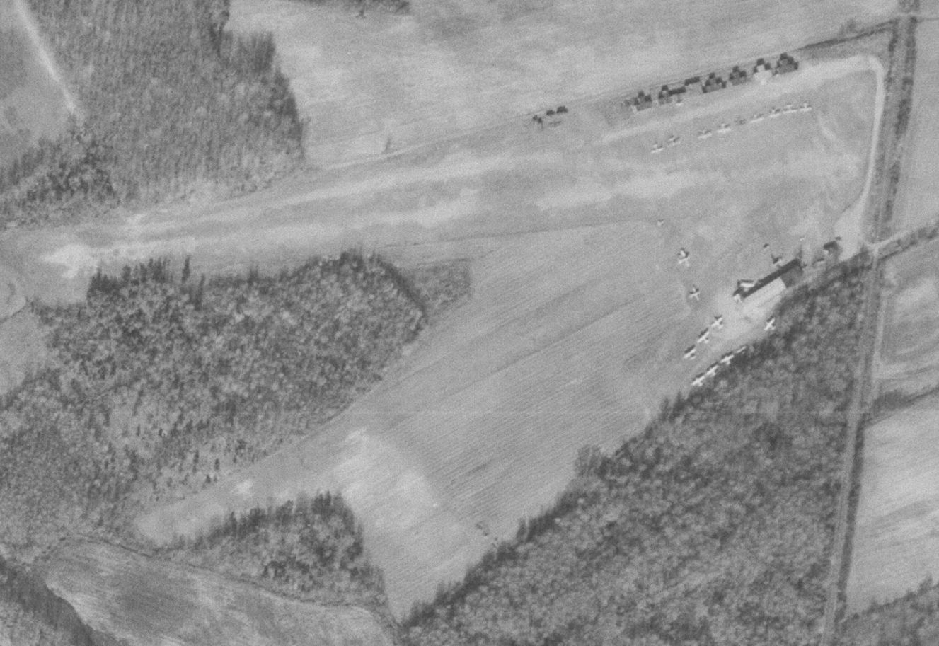
A 12/6/69 USGS aerial view depicted Preston Airport as quite popular, with over 20 light aircraft visible on the field.
Preston Airport was not depicted at all on the 1970 USGS topo map, inexplicably.
In 1970, Everett & Dorothy Fenwick bought Preston Airport.
A 1970 aerial view showed that a new, longer grass runway had been built somewhat to the north at some point between 1963-70.
The number of aircraft visible on the field had also blossomed to over 50.
Tim Farmer recalled, “Marlboro Airport [Preston] was a special place for me. I grew up about 5 miles away in Cheesequake.
The sight of the DelRosso's Stearman, which had been based at Marlboro,
over our home in the early 1970s may very well be what sparked my interest in aviation.
Numerous trips to the airport for family breakfasts followed by flights in that Stearman kept it alive (in those days they would charge $15 for a 20-30 minute flight).
I later learned to fly at Marlboro.”
Preston Airport had gained a paved runway at some point between 1970-72, as seen on a 1972 aerial photo.
Anton "Tony" Wittkamp recalled, “After Everett Fenwick & his wife Dorothy bought the airport in the early 1970s
a substantial amount of money was spent upgrading it & made it into one of the best general aviation airports in NJ.
We had Christmas parties at a local rented hall & cookouts in a grove of trees at the west end of Runway 27.
I still miss the airport and all the characters that met there regularly on Saturday & Sunday for breakfast
after which they went out to fly or just hung out in the small pilots' lounge.
The airport manager was Ed Kulus (also an FAA examiner) who later went to work for the FAA at Teterboro.
He ran a tight ship which benefited everyone.”

The 1975 NY Local Aeronautical Chart (courtesy of Mike Keefe) depicted Preston as having a 2,200' paved northeast/southwest strip.
Kevin Smith reported, “I learned to fly at Marlboro Airport in 1976-77. [It] was charming. I have good memories from there.”
The airport was renamed at some point between 1975-79 as Marlboro Airport, as that is how it was depicted on the 1979 NY TCA chart (courtesy of Bill Suffa).
It was described as having a single 2,200' paved east/west runway.

An undated aerial view looking northwest from the 1979 NJ Airport Directory depicted Marlboro Airport as having a single 2,170' asphalt Runway 9/27,
with taxiways, hangars, and a large number of light aircraft on the southeast side.
The manager was listed as Dorothy Fenwick, and the Fixed Base Operators as Deep Run Aviation & Marlboro Air Service.

The 1981 USGHS topo map depicted Marlboro Airport as having 2 paved runways.

A circa 1981 photo of Chuck Maire & his buddy with a Cessna 172 in front of a hangar at Marlboro Airport.
Chuck recalled, “I worked at Marlboro for the Fenwicks as a flight instructor.
It was the most country club type atmosphere I knew in my career.”

The 1983 Flight Guide (courtesy of Chris Kennedy) depicted Marlboro as having a single 2,159' paved Runway 9/27 & a parallel taxiway on the south side.
A total of 6 buildings (hangars?) were depicted on the airfield.

The June 1985 NY Sectional Chart (courtesy of Mitchell Hymowitz) depicted Marlboro Airport as having a 2,200' paved northeast/southwest strip.
Anton "Tony" Wittkamp recalled, “At its high point about 1985/90 there were probably 80-100 aircraft on the field.
This all went downhill after the death of Everett Fenwick at the young age of 58.
Those were indeed the 'good old days'.”
In April of 1986, Marlboro Airport was bought by Leonard & Aletta Genova for $750,000.

A September 1992 aerial view by Daniel Berek looking southeast at Marlboro Airport,
taken from a Stearman biplane, showing the airport quite healthy – with 18 light aircraft visible on the field.
The 1995 Jeppesen Airport Directory depicted Marlboro Airport in basically the same manner as shown in 1983.
In the late 1990s, in ill health, Dr. Genova attempted to find a buyer who would keep the airport open.
In July of 1997, Lino Fasio & his partners signed a contract to buy the airport for $1 million.
But in October of 1997, Fasio's partners & Genova backed-out of the deal, causing Fasio to sue.
A Superior Court judge temporarily barred the Genovas from selling the airport to anyone else.
In late 1997, the story of this embattled little airport took a very unfortunate turn, as Fasio claimed his 2 airplanes were being sabotaged.
On 3/4/98 Fasio's plane crashed into a condominium in Hillsborough, killing Fasio & his passenger, Eric Shibla.
In May of 1999, Marlboro Airport owner Dr. Genova died.
In August of 1999, developer Terry Sherman offered $1.2 million to buy the airport, but the offer was rejected by Mrs. Genova.
In February of 2000, Marlboro Holdings LLC, a company formed by a pilot & 2 Staten Island men, bought Marlboro Airport for $1.1 million.
An attorney representing the new owners said they intended to maintain the property as an airport
and "do everything possible to make it a prime airport facility."
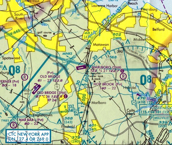
The last aeronautical chart depiction which has been located of Marlboro Airport was on the May 2000 NY Terminal Aeronautical Chart (courtesy of John Ferrara).
It depicted Marlboro as having a 2,100' paved northeast/southwest strip.
In late 2000, Marlboro Holdings & developers Anthony Spalliero & Terry Sherman
entered into a partnership to develop Marlboro Airport for housing, according to Spalliero.
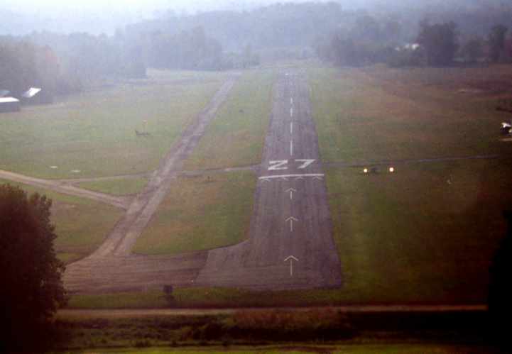
An October 2000 aerial view (courtesy of Tim Farmer), looking west at while on final approach for Marlboro's Runway 27.
Tim recalled, “It was taken late in the afternoon, on a very hazy day in October of 2000, upon return from Block Island, by my girlfriend Niveen.
It very well may have been the last approach & landing I ever made at Marlboro.
We moved to San Diego a few weeks later. Few airports have the charm that Marlboro did.
There was something about being there, especially on a warm spring morning with the smell of clover & fresh cut grass permeated the air & the sound of airplanes broke the silence.”

A 12/31/01 aerial view looking northwest depicted a popular Marlboro Airport just before the field's closure, with a large number of aircraft on the field.
Christopher Eng recalled, “I had a part-time job at the FBO at Marlboro Airport in the summer of 2001.
I always took flying lessons out of this airport with the MAFC. I was really sad to see this close as it seemed to be doing better before I left for college.”
In 2001 or 2002, Marlboro Mayor Matthew Scannapieco accepted a $100,000 bribe
to speed higher-density residential zoning on the airport, the mayor later admitted in federal court.

A vintage Soviet Antonov An-2 biplane, based at Marlboro Airport until its closure.

A spring 2002 photo of a Cessna 172 taking off from Marlboro, just months before the field closed.
In 2002, its last year of operation, its published statistics listed a total of 41 resident aircraft,
with an average of 61 takeoffs/landings per day.
Three business were based at the field in 2002: Marlboro Flight Services (the Fixed Base Operator),
Certified Flyers II (which provided flight training & aircraft rentals), and the Monmouth Area Flying Club.
Up until this airport's closure in 2002, its web site described itself as "The friendliest little airport in NJ!"
In conjunction with the change in ownership, a businessman who has operated at the airport for more than 3 decades said he was being evicted.
Richard Fenwick, president of Deep Run Repair & Aircraft Maintenance Corp., said he operated his business at the airport for 33 years.
Fenwick said he received an eviction notice from Marlboro Holdings shortly after their purchase of the airport.
Fenwick, whose brother, Everett Fenwick, was the former owner of Marlboro Airport, said he doesn’t know why the new owners are telling him to leave.
He said he does not have a lease for his space, having had understandings in place with each of the airport’s previous owners:
Ray Preston; then his brother & sister-in-law; and finally with Genova.
However, only 2 years after purchasing the airport, Marlboro Holdings LLC announced their plans to close the airport in 2002
and redevelop the property for a more financially lucrative purpose - building housing.
But the patrons of the airport, many of whom had been coming for decades, began a grassroots movement with hopes of preserving the facility.
Known as the Committee to Save Marlboro Airport, the group circulated a petition against rezoning the property.
Marlboro Holdings LLC requested a change in zoning that would allow for the construction of an adult community of about 300 homes.
A flier distributed by the Committee to Save Marlboro Airport stated,
"It has never been a secret that since the sale of the airport to its present ownership,
there has always been a subversive desire to close the airport & rezone it for another housing project."
State Department of Transportation spokesman John Dourgarian said he had not heard of plans to close the airport.
"Certainly, we’d like to see Marlboro Airport preserved," Dourgarian said.
"We don’t have a lot of (general aviation airports) left ... when you lose one it affects all of the others."
Dourgarian said the airport’s safety record was not considered noteworthy.
Marlboro is one of 50 general aviation airports left in the state, he said.
According to Rasmussen, of the DOT, the Marlboro Airport owners made no requests for financial assistance.
Members of the Committee to Save Marlboro Airport said they know the odds are long.
"We’re not sophisticated in any political way - we’re just a group of people who know right from wrong," said Jay Thorpe.
"It’s really like David & Goliath, except Goliath has no face. Goliath didn’t need to show up at Planning Board meetings."
But ultimately their efforts were not successful, and the airport's closure was made final in 2002.
In the letter to municipal officials, Berman seemed to address financial issues relating to the facility,
adding, "Despite our best efforts, we have to face the reality that it is not possible for us to continue to operate the property as an airport."
However, several airport supporters have said it was mismanagement on the owners’ part that was responsible for any losses.
"It’s interesting to me that it remained profitable for more than 40 years before they owned it.
You don’t have to be a business major to see that they’ve tried to run the place into the ground," Thorpe said.
Marlboro Councilwoman Mary Singer said, "The airport’s been a real asset for Marlboro, and I’m disappointed they couldn’t find a different buyer.
It’s different than buying something like a drugstore & keeping it open as a drugstore - it’s a very specialized operation."
Aircraft owners at Marlboro Airport were forced to seek new spaces among a quickly shrinking group of general aviation airports in New Jersey.
Since WW2, New Jersey has lost about one small airport per year, according to state Department of Transportation spokesman Micah Rasmussen.
When Marlboro Airport closed in 2002, only 48 small general aviation airports were left statewide.
In Monmouth County, only 2 airports will remain (Monmouth Executive & Old Bridge).
According to airport mechanic Bill Bienes, "People who have their airplanes in New Jersey are not going to get hangars in New Jersey.
There are none to be had."

Aerial view of Marlboro looking west, shortly after its closure. © 2002 by Rich Galiano, used by permission.

Aerial view of Marlboro looking east, shortly after its closure. © 2002 by Rich Galiano, used by permission.

A view over the end of Runway 27 to the northwest at the hangars at Marlboro. © 2002 by Rich Galiano, used by permission.
At the time of its closure, the airfield at Marlboro consisted of a single 2,156' asphalt Runway 9/27,
asphalt taxiways, a grass tie-down area, several T-hangars, and office, and a popular café.
The property consisted of a total of 53 acres.
Rich Galiano reported in 2003 that "Zoning problems seem to be holding up the redevelopment of Marlboro,
which is virtually unchanged since it closed, except for some vandalism of the now-vacant buildings."
Rich Galiano reported in 2004, "I flew over Marlboro the other day: the runway is still intact.
I guess when the new owners turned out to be sleazy developers,
the town decided to screw them, and the re-zoning never went through.
They wanted to build old-folks housing, what a local graffito referred to as a 'Senior ghetto'."
William Angus reported in 2005, “Marlboro Airport seems to be in the same shape & position as it was in the most recent reports, though the buildings may have deteriorated.
I drove by... the place was plastered with no trespassing signs.”
In a sad postscript to the Marlboro Airport story, in April of 2005, former Mayor Scannapieco plead guilty in federal court
to accepting a total of $245,000 from a developer, later identified as Spalliero.
In May of 2005, Spalliero was charged in federal court for passing bribes to public officials, including $100,000 to Scannapieco.
Rob Kulat reported in 2005, “Recently I've been reading that many residents want it to be an airport again instead of more housing.
People are starting to wake up to the fact that life would be worse with more traffic & houses, rather than with a few aircraft.”

A July 2006 photo of the former Marlboro hangars by Andy Zink.
Andy reported, “There's a bike path that runs right by the end of the runway.
Nothing has really changed recently except a few more pieces of grass breaking through the runway & taxiways. Some of the hangars are open.”
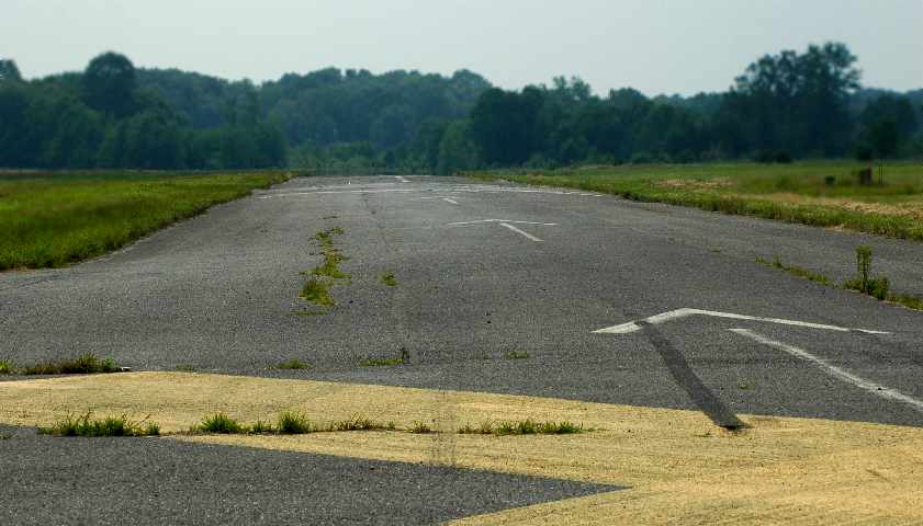
A July 2006 photo of the former Marlboro runway by Andy Zink.

A July 2006 photo of former hangars on both sides of the runway at Marlboro by Andy Zink.

A circa 2007 photo of the sign at the entrance to Marlboro Airport.
Anton "Tony" Wittkamp recalled, “I I visited Marlboro Airport in June 2010.
I walked the entire airport & its current condition brought tears to my eyes.
The buildings are in a state of decay except the office, pilots lounge & cafe which seem to be holding up OK.
The large metal hangar next to the cafe is still in good shape but other hangars on the north & west side are falling apart.
The runway is still in good shape although weeds are coming up from the cracks & I suspect will now accelerate due to lack of use.”

A sad 9/6/13 aerial view looking northwest at the remains of Marlboro Airport.
What a shame that the aviation infrastructure of this nice little general aviation airport continues to be wasted.
Candee Preston (daughter of the Preston Airport founder) recalled, “I chuckle when I read how the people of Marlboro wanted to save the airport.
Growing up, most of the area residents wanted it closed. How times have changed.”

A 12/21/16 photo by James Zimenoff looking south at the end of Marlboro Airport's former Runway 9, towards the old hangars.
James reported, “It seems that the area adjacent to the taxiway on the Runway 9 end of the field was cleared & is being used as part of a deer hunting area, as evidenced by the signs.”

A still from an 8/27/17 aerial video by Philip Kineyko of www.FlyinPhilsPhotos.com looking east along the remains of Marlboro Airport's Runway 9.

A 6/20/18 aerial view by Kevin Smith looking east at the remains of Marlboro Airport. What a shame to see this nice aviation infrastructure going to waste.

A 6/20/18 photo by Kevin Smith looking west at the remains of Marlboro Airport's Runway 27, showing the runway numbers still visible.
Kevin Smith reported, “It has been cleaned up a little & would even make an acceptable emergency runway (the numbers are still visible & the Xs have washed away, apparently).
The CFI I flew with figures maybe it was cleaned up to be more amenable to the mausoleum next door.”
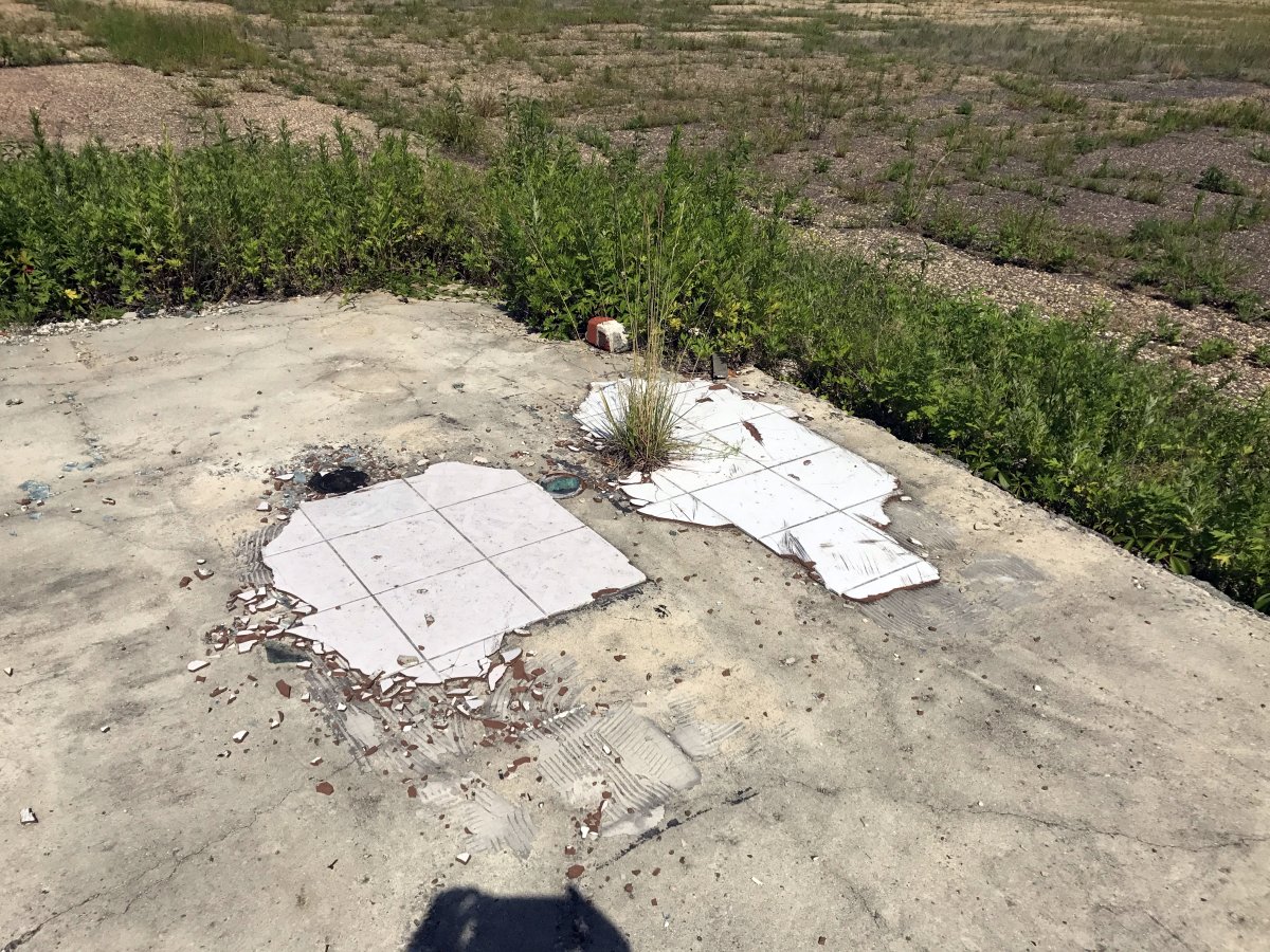
A 6/20/18 photo by Kevin Smith of the remains of a tile floor at the site of Marlboro Airport.

A 6/20/18 photo by Kevin Smith of the remains of a ramp at the site of Marlboro Airport.

A 7/26/18 photo by Christopher Eng looking west at the remains of Marlboro Airport's Runway 27, showing the runway numbers which evidently were repainted at some point between 2018-2020.
Christopher reported, “It has become part of the County park system. So at least the grounds won't become more housing developments. It is now called the Wickatunk Recreation Area.”
According to the County park website, "Named after the Lenape word for 'finishing place', the 98-acre Wickatunk Recreation Area offers fields & forests.
Established in 2010, the site is home to the former Marlboro Airport & the recently-acquired Spring Valley section.
Since its initial acquisition, the Park System has cleared remnants of the airport & is preserving the Airport Meadows section as open space.”
In October 2022, NJ Transit used the Marlboro runway & taxiways for testing of the AVATAR (Autonomous Vehicle Assessment, Testing And Research) autonomous vehicle.
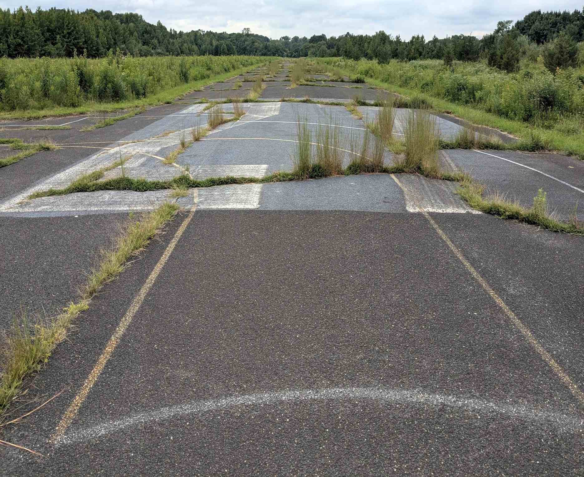
A 8/22/26 photo by Christopher Eng looking down Marlboro's Runway 27.
Christopher Eng reported, “The runway & taxiways have continued to deteriorate with more grass growing through cracks.”
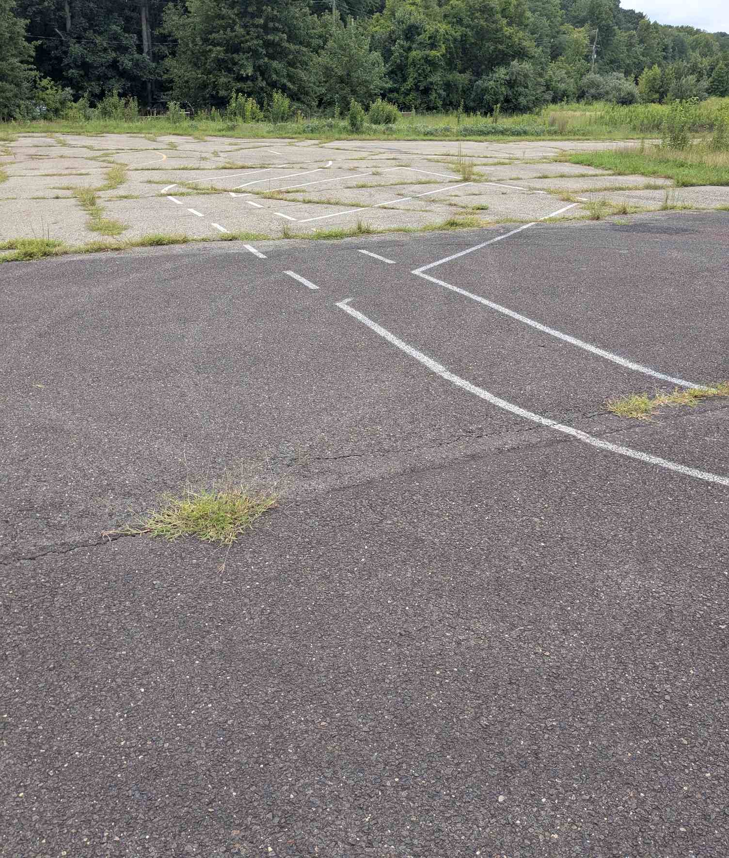
A 8/22/26 photo by Christopher Eng of Marlboro's Runway 27 runup area.
Christopher Eng reported, “You can see some of the markings left behind by the AVATAR testing.”
The site of Marlboro Airport is located west of Route 79, south of Brown Road.
See also:
____________________________________________________
Or if you prefer to contact me directly concerning a contribution (for a mailing address to send a check),
please contact me at: paulandterryfreeman@gmail.com
If you enjoy this web site, please support it with a financial contribution.
____________________________________________________
This site covers airfields in all 50 states.