
Abandoned & Little-Known Airfields:
New York State: Orange County
© 2002, © 2026 by Paul Freeman. Revised 6/30/26.
This site covers airfields in all 50 states: Click here for the site's main menu.
____________________________________________________
Please consider a financial contribution to support the continued growth & operation of this site.
County Seat Airport / Monticello Airport (revised 7/22/21) - Huguenot Airport (revised 6/30/26)
Tri-State Airport / Montgomery Airport (revised 5/12/26) - Walden Airport (revised 11/11/25)
____________________________________________________
Tri-State Airport / Montgomery Airport, Montgomery, NY
41.516, -74.252 (North of New York, NY)
Tri-State Airport, as depicted on the August 1932 NY Sectional Chart.
According to the article “Montgomery's Tri-States Airport” in the 9/27/16 Wallkill Valley Times (courtesy of Jeff Gorss),
Tri-State Airport was dedicated in June 1931.
The earliest depiction which has been located of Tri-State Airport was on the August 1932 NY Sectional Chart.
It depicted Tri-State as a commercial/municipal field.
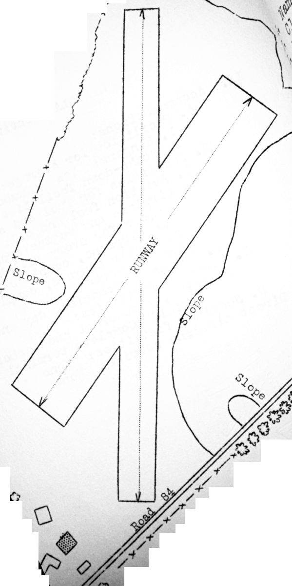
The 1938 Aviation Facilities in NY State (courtesy of Bob Parmerter) described Tri States Airways Airport as having 2 sandy loam runways, measuring 1,800' north/south & 1,400' northeast/southwest, and 1 hangar on the southwest side.

The earliest photo which has been located of Tri-State Airport was an 8/7/42 aerial view looking north from the 1945 AAF Airfield Directory (courtesy of Scott Murdock).
It depicted “Tri-States Airport” as an open grass area with a few small buildings on the southwest side.

Tri-State Airport, as depicted on the 1943 USGS topo map.
The 1945 AAF Airfield Directory (courtesy of Scott Murdock) described “Tri-States Airport”
as a 120 acre irregularly-shaped property having a sod all-way landing area, with the longest dimension being 2,200' north/south.
The field was said to have 3 hangars, the largest being a 180' x 30' wood & metal structure.
Tri-States Airport was described as being owned & operated by private interests.
According to Jeff Gorss, “Tri-State Airport pre-dates the present-day Orange County Airport & was located almost immediately north-east of where that facility was constructed.
My father & my uncle were the operators of the grass-strip Tri-State Airport in the late 1940s.
My father was a B-17 & B-24 pilot at the end of WW II, and my uncle had been a civilian instructor for the Civilian Pilot Training Program.
Together they opened Gorss Flying Service at the Tri-State Airport – they ran what we now generally refer to as an Fixed-Base Operation.
They flew power line patrols; offered flying lessons, fuel, hangars & tie-down rentals; and provided aircraft inspection & repair services.
I’ve been told that planes on straight floats occasionally landed on a nearby stretch of the Wallkill River for inspections (and possibly for certain types of repairs).
Along with T-hangars & a small office/classroom building, there was a fairly large maintenance hangar that could accommodate several planes at a time.”
According to LeRoy Bettcher, “The [Tri-State] airport property was owned by the Stickles Brothers, Reggie & Walt.
They also owned & ran the Airport Inn & surrounding farm land.
Reggie was a character: long hair & beard, rags for clothes, held up by a rope as a belt, drove an old old car (still had wooden wheels), and he would come downtown & recite poetry.”
Dave Walmsley recalled, “When I was flying out of the old airport, the Stickles brothers owned it –
Lloyd (who ran the bar in the adjacent Airport Inn, which they also owned), and his older brother.”

An undated photo of Jerry & Don Gorss with a Piper Cub undergoing maintenance at Tri-State Airport (courtesy of Chris Jacks, via Jeff Gorss).

A circa 1946 photo (courtesy of Jeff Gorss) of 2 small buildings in front of the hangar with “TRI-STATE AIR PORT” painted on its roof.
Jeff Gorss noted, “I’m pretty sure that’s my father, Don Gorss, in the doorway of the small building under construction, and either my grandfather Fred Gorss or uncle Wray Osterhaut leaning on what appears to be the next roof panel for the small building.”

An undated photo of Jerry & Lynne Gorss in front of the Airport Inn at Tri-State Airport (courtesy of Chris Jacks, via Jeff Gorss).

An undated photo of Lynne Gorss in front of a hangar at Tri-State Airport (courtesy of Chris Jacks, via Jeff Gorss).
According to Jeff Gorss, “Sometime after 10/31/48 (the last entry in my father’s logbook),
a fire started by some welding work resulted in the maintenance hangar burning to the ground, along with several planes inside it.
After the hangar fire at Tri-State, the Gorss brothers tried to work with the county to develop KMGJ [the present-day Orange County Airport]
into an active general aviation facility, but their efforts were for naught.
Without the maintenance hangar & the business income it provided, Tri-State was no longer a viable operation,
the Gorss brothers moved on to other endeavors, and Tri-State eventually degraded to cornfields & abandoned vehicles.”

A circa 1954 view of Tri-State Airport looking north, submitted by Jeff Gorss (courtesy of Chris Jacks).
Jeff observed, “T-hangars & several support buildings were still in existence at the time, as was the Airport Inn (the larger white building closest to the highway) at the near end of one of the grass runways.”

The 1956 USGS topo map depicted Tri-State Airport as having a single northwest/southeast unpaved runway,
with a few small buildings on the southwest side.
It also depicted how close the “Montgomery Airport” was located, less than a quarter-mile to the southwest.

A 7/21/58 USGS aerial view depicted Tri-State Airport as having 2 grass runways.
What appear to be 4 light aircraft were visible parked near the buildings on the southwest side.

At some point between 1956-59, the airport was evidently renamed “Montgomery”,
as the former Montgomery Airport to the southwest was renamed Orange County,
as depicted on the 1959 USGS topo map.
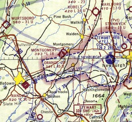
The last aeronautical chart depiction which has been located of the Montgomery Airport was on the 1965 NY Sectional Chart.
Montgomery Airport's depicted runway length had shrunken to only 1,800'.
Montgomery Airport was evidently closed at some point between 1965-67,
as it was no longer depicted on the 1967 NY Sectional Chart.

A 4/27/74 USGS aerial view showed that the Tri-State Airport site was still mostly intact,
though a portion of the northwest/southeast runway had been plowed over at some point between 1958-74.

A 2013 aerial view showed the majority of the site of Tri-State Airport remained clear.
The small building at the southwest corner possibly remained from the site's airport days.

A 7/3/16 aerial view by Paul Freeman looking southeast at the site of Tri-State Airport.
Jeff Gorss reported in 2017, “The Airport Inn – which appears in the background in one of the photos – still stands & is still in operation as far as I can tell.”

A September 2019 photo looking west at the Airport Inn which remains at the southeast portion of the Tri-State Airport site, along with another small building possibly dating to its airport days.
The site of Tri-State Airport is located north of the intersection of Union Street & Route 416.
Thanks to Jeff Gorss for pointing out this airfield.
____________________________________________________
Huguenot Airport, Huguenot, NY
41.406, -74.644 (Northwest of New York, NY)

Huguenot Airport, as depicted on the November 1938 NY Sectional Chart.
According to Rich MacVicar, Huguenot Airport “opened about 1931 or 32. A friend soloed there in 1932.”
However, Huguenot Airport was not depicted on the 1933, 1935, 1937, or April 1938 NY Sectional Charts.
The earliest depiction which has been located of Huguenot Airport was on the November 1938 NY Sectional Chart,
which depicted it as a commercial/municipal airport.
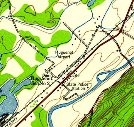
The earliest topo map depiction which has been located of Huguenot Airport was on the 1942 USGS topo map.
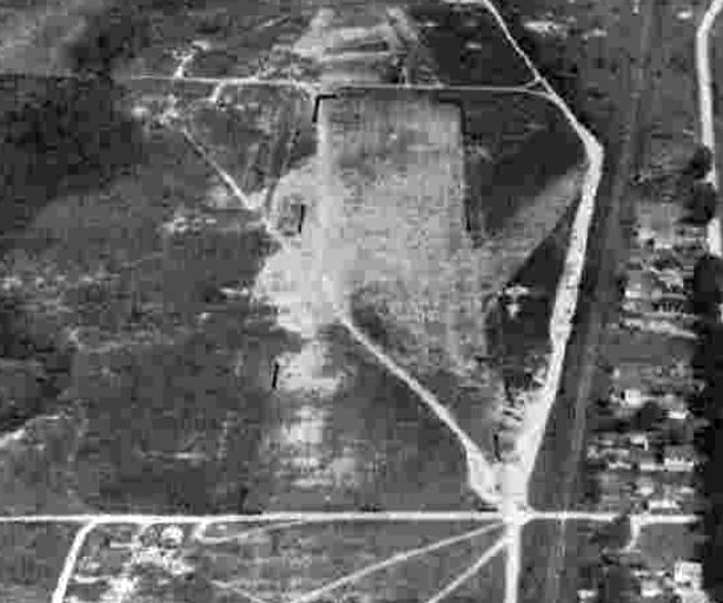
The earliest photo which has been located of Huguenot Airport was a 9/6/42 aerial view looking northeast from the 1945 AAF Airfield Directory (courtesy of Scott Murdock).
It depicted Huguenot as having a single unpaved runway.
According to the Town of Deerpark Historian Norma Schadt, “The Civil Air Patrol was active in the airport during World War II.”
Jack Taipale recalled, “Harry Gordon, the summer [of 1943] started an operation at Huguenot Airport, where I soloed in August of 1943.”
According to Rich MacVicar, “A guy named Felix Muchoe said he ran it in 1944 or sooner.”

The January 1945 NY Sectional Chart (courtesy of Ron Plante) depicted Huguenot as a commercial/municipal airport.
The 1945 AAF Airfield Directory (courtesy of Scott Murdock) described Huguenot Airport as a 52 acre property having a single 2,050' turf northeast/southwest runway.
The field was said to have a single hangar, and to be owned & operated by private interests.
According to the Town of Deerpark Historian Norma Schadt, Huguenot Airport was listed in the 1948 T. B. Haire Airport Directory,
and there was a reference to the airport in the 7/25/49 Middletown Times Herald.

An undated aerial view looking south at Huguenot Airport (courtesy of Norma Schadt)
showed 4 single-engine planes parked around 3 small hangars on the southeast side of a grass airfield.

An undated photo of Betty Ehre hand-propping a Cessna T-50 at Huguenot Airport (courtesy of Norma Schadt).

An undated photo of a Skyranger at Huguenot Airport (courtesy of Norma Schadt), also showing several other planes in front of a hangar.
According to Rich MacVicar, “The Skyranger was one of the Skyrangers stored there when the factory in Long Island folded.
All of the unsold aircraft were stored at Huguenot airport.”

An undated photo of George McGinnis in front of a Civil Air Patrol Aeronca at Huguenot Airport (courtesy of Norma Schadt).
The photo is 1948 or later, judging from the Aeronca's USAF insignia.

The last aeronautical chart depiction which has been located of Huguenot Airport
was on the July 1950 NY Sectional Chart (courtesy of Jim Stanton).
It depicted Huguenot as having a 2,000' unpaved runway.
According to Rich MacVicar, the Huguenot Airport “was busy until about 1951 or 1952.”
Huguenot Airport was evidently closed (for reasons unknown) by 1952
as it was no longer depicted on the 1952 NY Sectional Chart or subsequent aeronautical charts.
According to Rich MacVicar, “In 1954 or 1955 the Rockland County Civil Air Patrol took it over for a short time
and we ran out of there during the big flood in 1956.”
According to the Town of Deerpark Historian Norma Schadt there was a reference to Huguenot Airport in the 11/10/58 Middletown Times Herald.
According to Norma Schadt, “The Huguenot Airport stopped service in the 1960s.”

The last photo which has been located showing Huguenot Airport still intact was a 4/8/63 aerial view.
It depicted the field to have a single unpaved northeast/southwest runway, with 2 small hangars on the southeast side.
Although the field remained intact, there was no sign of recent aviation usage.
According to Rich MacVicar, “It was still open when I came to Middletown in 1964.”
A 1968 aerial photo showed some houses had been built on either end of the Huguenot runway,
but the majority of the runway remained intact, along with 2 hangars.
According to Rich MacVicar, “A guy was doing some commercial work [at Huguenot] with a Cessna 175 up until about 1968 or 1969.
Then it was sold & closed & became a trailer park.”
A 1975 aerial photo showed more houses had been built on the northeast end of the Huguenot runway,
but the 2 hangars remained standing.
A 1998 USGS aerial photo showed the hangars had been removed at some point between 1975-98.
Houses covered the site, with no remaining trace of Huguenot Airport.

A 9/12/12 aerial view showed no trace remaining of Huguenot Airport.
Town of Deerpark Historian Norma Schadt reported in 2013, “Today the land is a mobile home park called 'Airport Park'.”
The site of Huguenot Airport is located at the intersection of Airport Road & Hangar Road, appropriately enough.
____________________________________________________
41.53, -74.207 (North of New York, NY)
Walden Airport, as depicted on the August 1932 NY Sectional Chart.
This general aviation airport was not yet depicted on the 1929 Rand-McNally Standard Map of NY with Air Trails.
According to James Stanton, “Walden Airport opened [on] Memorial Day 1931.”
According to an article in the 12/17/03 issue of the Times Herald-Record,
Pilot John Sanford recalled that “the Tillson-Walden Airport” was the de facto center of the regional aviation movement.
Charles Lindbergh & Amelia Earhart both made visits there. John recalled, "I saw Lindy at the airfield.”
Sanford spent the early part of the 1930s learning to fly there
and his instructor was an Austrian pilot named Egan Pelzeder, a former World War I fighter pilot.
"A great fella... we were like 2 peas in a pod", Sanford said. "He was my first serious instructor."
That teacher-student relationship endured for more than 18 months before ending with Pelzeder's death.
He died in a plane crash in 1931.
The earliest depiction which has been located of Walden Airport was on the August 1932 NY Sectional Chart.
It depicted Walden as a commercial/municipal field.

The earliest photo which has been located of Walden Airport was an undated aerial view looking northwest
from The Airport Directory Company's 1933 Airport Directory (courtesy of Chris Kennedy).
It depicted Walden Airport as having 3 sod runways, with the longest being the 2,960' north/south strip.
The field was said to consist of a total of 96 acres, irregularly-shaped.
A single hangar was depicted just to the northeast of the runway intersection.
The operators were listed as Roy Munroe & Tillson Flying Service, and the owner was listed as Earl Tillson.

The 1938 Aviation Facilities in NY State (courtesy of Bob Parmerter) described Walden Airport as having 4 sod runways, the longest measuring 2,960' north/south, 1 hangar on the east side.

The 1942 USGS topo map depicted Walden Airport as having 3 unpaved runways, with a hangar just east of the runway intersection.

A 8/7/42 aerial view looking north from the 1945 AAF Airfield Directory (courtesy of Scott Murdock)
depicted Walden Airport as an open grass area with a building on the east side.
The 1945 AAF Airfield Directory (courtesy of Scott Murdock) described Walden Airport
as a 110 acre irregularly-shaped property having a sod all-way landing area, with the longest dimension being 3,200' north/south.
The field was said to have 3 metal & wood hangars, the largest measuring 100' x 30'.
Walden Airport was described as being owned & operated by private interests.

Ellen Stekert observed, “These photos show a young pilot, 15 years old, [Jim Stekert], whose parents took him to Walden for a flying lesson.
The boy had just taken a course in flying at Lafayette College in Easton, PA.
The father has annotated the snapshots. One picture shows the instructor, perhaps the owner of the field, starting the propeller on the Piper Cub the boy flew.”

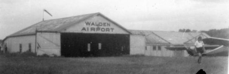
Ellen Stekert recalled, “I had my first flight at that time - the instructor told me that I could wave the wings at my family when we were over them.
Of course he did not tell me how to do it, so I jiggled the stick back & forth abruptly - I think it just looked like a stutter. It did shake up the instructor.”

The 1946 USGS topo map depicted Walden Airport as having 2 runways, with a hangar just east of the runway intersection.
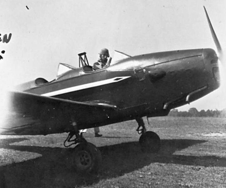
A 9/9/46 photo by Martin Stekert (courtesy of Ellen Stekert) of a Fairchild PT-19 at Walden Airfield.
According to Ellen Stekert, “This was taken after the son had turned 16 years old.
The father had worked in the early airplane industry in New Jersey during WWI & was determined to give his son the opportunity to become a pilot, an opportunity he had never had.
WW2 had just ended & the importance of the air industry was well noted by the father.
The family spent their summer vacation time at a farm near the Walden Airport that took in summer visitors (Lucht's Farm).”

The 1957 USGS topo map depicted the “Newburgh-Walden Landing Field” as having 2 unpaved runways,
with several small buildings just northeast of the runway intersection.
The area surrounding the field was already depicted as a golf course.

The last aeronautical chart depiction which has been located of the Walden Airport
was on the January 1958 NY Sectional Chart (courtesy of Chris Kennedy).
It depicted “Newburgh-Walden” as having a 3,000' unpaved runway.
Peter O'Brien recalled, “Walden Airport was one of my cross-country stops when I was learning to fly at Christie Airport in New City in 1958.
I remember when landing at Walden you had to look out for golfers who would at times cross the runway from one tee to the other.”

The last photo which has been located showing Walden Airport while still in operation was an 8/5/58 USGS aerial view.
It depicted a small hangar on the east side of 2 unpaved runways.
According to James Stanton, “Walden Airport closed 6/30/60.”
The Walden Airport was no longer listed among active airfields in the 1960 Jeppesen Airway Manual (according to Chris Kennedy).
Ken Barnes recalled, “While the airport was 'closed' for a while in the early 1960s (when my father owned the golf course)
planes still appeared now & then rather unexpectedly!
I remember being quite excited when a plane landed one day (quite unannounced) just a few yards from the 1st tee.
I don’t know who was more shocked:
the golfers or the pilot (who must have surely wondered where the windsock was)!”
A 4/2/74 USGS aerial view showed the hangars remaining, and the airport circle marking remained recognizable to the west of the hangars,
but there was no aircraft or other signs of recent aviation use.

The 1986 USGS topo map continued to depict Walden Airport's 2 runways, labeled simply as “Landing Strips”.

A 2003 aerial view showed the 2 grass runways of the former Walden Airport to remain clear, and the 1930s-vintage hangar remained standing as well.
As of 2006, road maps labeled the site of Walden Airport as the Scott's Corners Golf Course.

A circa 2008 aerial view looking north at the 1930s-vintage hangar which remains standing at the site of Walden Airport.
The site of Walden Airport is located northwest of the intersection of Route 208 & Route 17K.
____________________________________________________
Or if you prefer to contact me directly concerning a contribution (for a mailing address to send a check),
please contact me at: paulandterryfreeman@gmail.com
If you enjoy this web site, please support it with a financial contribution.
____________________________________________________
This site covers airfields in all 50 states.