
Abandoned & Little-Known Airfields:
Western Ohio
© 2002, © 2026 by Paul Freeman. Revised 6/18/26.
This site covers airfields in all 50 states: Click here for the site's main menu.
____________________________________________________
Please consider a financial contribution to support the continued growth & operation of this site.
Bellefontaine Municipal (revised 6/18/26) - Darby Dan Airport (revised 12/16/25) - Josephinum Airfield (added 6/9/23) - Lansdowne Airport (revised 9/21/21)
Price Field (revised 6/10/23) - (Original) Springfield Municipal Airport (revised 6/10/23) - Treaty City Airport (revised 10/23/24) -
____________________________________________________
Treaty City Airport, Greenville, OH
40.122, -84.617 (Northwest of Columbus, OH)
Treaty City Airport, as depicted on the November 1936 Chicago Sectional Chart.
This general aviation airport was located on the northeast side of the town of Greenville was evidently established at some point in 1936,
as it was not yet depicted on the April 1936 Chicago Sectional Chart.
The earliest depiction which has been located of Treaty City Airport was on the November 1936 Chicago Sectional Chart.
It depicted Treaty City as a commercial/municipal airport.

The earliest photo which has been located of Treaty City Airport was a 9/28/43 aerial view from the 1945 AAF Airfield Directory (courtesy of Scott Murdock).
It depicted Treaty City Airport as having 2 unpaved perpendicular runways.
The 1945 AAF Airfield Directory (courtesy of Scott Murdock) described Treaty City Airport
as a 67 acre irregularly-shaped field having 2 sod runways, measuring 1,980' north/south & 1,850' east/west.
The field was said to have 2 hangars, the largest being a 95' x 50' wood & metal structure.
Treaty City Airport was was described as being owned & operated by private interests.

A 9/6/52 USGS aerial view depicted Treaty City Airport as having an unpaved east/west runway, with several small hangars on the west side.

The 1953 Chicago Sectional Chart depicted Treaty City Airport as having a 2,800' unpaved runway.

An undated aerial view of Treaty City Airport (courtesy of Jim Hocker) depicted 3 light aircraft parked near several hangars.

An undated photo (courtesy of Jim Hocker) of a Cessna 172 part-owned by Harry Campbell in front of the Treaty City Airport hangars & beacon tower.

The 1960 OH Airport Directory (courtesy of Jim Hocker) depicted Treaty City Airport as having 3 sod runways & several buildings on the west side.
It listed the manager as Mrs. Wm. Bleyle.

The June 1961 Chicago Sectional Chart depicted Treaty City Airport as having a 2,800' unpaved runway.

The 1961 USGS topo map depicted Treaty City Airport as having 3 unpaved runways, and several small buildings & a beacon on the west side.

Treaty City Airport apparently lost 2 of its 3 runways at some point between 1961-73,
as the 1973 USGS topo map showed a large building had been built over the north portion of 2 of the runways,
and only the east/west runway was still depicted.

The last photo which has been located showing Treaty City Airport still in operation was a 10/14/73 USGS aerial view.
It depicted the single east/west unpaved runway, and the hangars on the west side.

The last aeronautical chart depiction which has been located of Treaty City Airport was on the November 1974 Detroit Sectional Chart (courtesy of Ron Plante).
It depicted Treaty City Airport as having a 2,800' unpaved runway.

Treaty City Airport was evidently closed at some point between 1974-94,
as a 1994 USGS aerial view showed another large building had been constructed over the west portion of the east/west runway.
But the eastern portion of the east/west runway remained recognizable, along with the hangars on the west side.
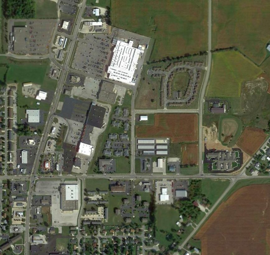
A 2014 aerial view of the site of Treaty City Airport showed buildings had covered the remainder of the east/west runway,
with several hangars on the west side remaining as the last trace of this airport.

A 5/2/15 photo by Jim Hocker of 2 former Treaty City Airport hangars.
Jim observed, “Both are drive-through structures, one selling beverages & the other animal feed.”

A 5/2/15 photo by Jim Hocker of the back side of a former Treaty City Airport hangar.
The site of Treaty City Airport is located east of the intersection of Wagner Avenue & Russ Road.
Thanks to Jim Hocker for pointing out this airfield.
____________________________________________________
Lansdowne Airport, Greenville, OH
40.09, -84.6 (Northwest of Columbus, OH)

A Souvenir program of the 9/23/28 Dedication of Lansdowne Airport (courtesy of Jim Hocker).
This general aviation airport on the southeast side of the town of Greenville
was dedicated on 9/23/28, according to a Souvenir Program of the Dedication (courtesy of Jim Hocker).

The earliest photo which has been located of Lansdowne Airport was a circa 1920s/30s photo (courtesy of Jim Hocker) of a barn with “Lansdowne Airport” painted on its roof.

The earliest aeronautical chart depiction which has been located of Lansdowne Airport was on the December 1930 Chicago Sectional Chart.
It depicted Lansdowne Airport as a commercial/municipal airport.
Lansdowne Airport may have gone through a period of closure during WW2, (like many other small civilian airports)
as it was not listed among active airfields in the 1945 AAF Airfield Directory (courtesy of Scott Murdock).
The 1953 Chicago Sectional Chart depicted Lansdowne Airport as having a mere 1,800' unpaved runway.

An undated diagram (courtesy of Jim Hocker) depicted Lansdowne Airport as having 3 runways, and 2 small buildings on the northwest side.

The 1961 USGS topo map depicted “Lansdowne Landing Strip” as having 2 unpaved perpendicular runways,
with a few small buildings on the northwest & southwest sides.
Lansdowne Airport was evidently closed (for reasons unknown) at some point between 1953-61,
as it was no longer depicted on the June 1961 Chicago Sectional Chart.

The 1989 USGS topo map still depicted 2 runways labeled as “Lansdowne Landing Strip”,
even though the airport had evidently been closed for at least 28 years by that point.

A 1994 USGS aerial view still depicted traces of 2 perpendicular unpaved runways at the site of Lansdowne Airport,
although a building had been built over the east end of the east/west runway.

A 2014 aerial view of the site of Lansdowne Airport showed buildings & roads had covered most of the airport site,
but amazingly the outline of the east end of the former east/west runway is still recognizable as a gap in the planted crops.
The site of Lansdowne Airport is located east of the intersection of Jaysville - St. Johns Road & Lansdowne Road.
Thanks to Jim Hocker for pointing out this airfield.
____________________________________________________
Bellefontaine Municipal Airport (7I7), Bellefontaine, OH
40.41, -83.74 (Northeast of Dayton, OH)

Bellefontaine Airport, as depicted on the May 1967 Cleveland Sectional Chart.
This municipal airport was apparently built at some point between 1966-68,
as it was not depicted on a 1959 aerial photo, the 1961 USGS topo map, nor the November 1966 Cleveland Sectional Chart.
The earliest depiction which has been located of Bellefontaine Airport was on the May 1967 Cleveland Sectional Chart.
It depicted Bellefontaine Airport as having a single 4,400' paved northeast/southwest runway.

The earliest photo which has been located of Bellefontaine Airport was a 1971 aerial view (courtesy of Dennis Thompson).
It depicted Bellefontaine Airport as having a paved Runway 4/22, with the airport name painted on on, and a paved ramp with a hangar on the northwest side.
But there were no aircraft visible on the field.

The 1973 USGS topo map depicted Bellefontaine Airport as having a single paved northeast/southwest airport with a ramp & 2 buildings on the northwest side.
The 1976 AOPA Airport Directory (courtesy of Chris Kennedy) described Bellefontaine Municipal as having a single 4,400' asphalt Runway 4/22,
and said that the field offered hangars, flight instruction, and charters.
The operator was listed as Dynamic Aviation, Inc.
The 1982 AOPA Airport Directory (courtesy of Ed Drury) described Bellefontaine Municipal
as having a single 4,400' asphalt Runway 4/22, and listed the operator as Brenner Air Service.
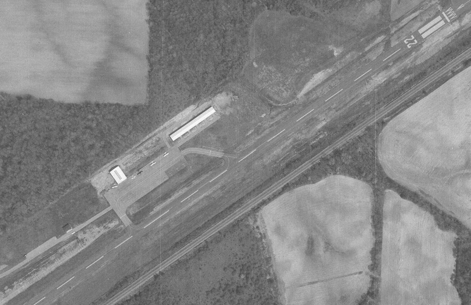
The earliest photo which has been located showing Bellefontaine Airport while in operation was a 1982 aerial view (courtesy of Dennis Thompson), which showed 5 light single-engine aircraft on its ramp.
A 2nd hangar had also been added at some point between 1971-82.
Unfortunately, constraints on the growth of the original Municipal Airport would eventually cause its replacement.
The existing airport had a 4,400' runway, with turn-arounds on each end.
The landing thresholds for both runway ends were displaced 200' due to obstructions in the approaches.
Expanding the existing airport to meet forecasted demand would be limited due to existing constraints,
including State Road 68 & a nearby railroad & landfill.
As described in AOPA Online, planning for a replacement airport for the city of Bellefontaine began in the 1980s,
when Robert Lentz, then a city councilman began pushing for a replacement airfield.
The plan originally faced strong opposition, but over time, and with the help of the aviation community,
Lentz won enough support for the project to go ahead.
The community effort continued when a local businessman & area pilot agreed to buy
the current FBO (Midwest Corporate Air) & take over management of the airport for the city.

A 1990 aerial view looking northwest at Bellefontaine Airport (courtesy of Dennis Thompson) showed 1 light aircraft on its ramp.

The last photo which has been located showing Bellefontaine Airport while in operation was a a 1995 aerial view (courtesy of Dennis Thompson), which showed 8 light aircraft aircraft on its ramp, including 2 twin-engine aircraft.

The 2001 OH Airport Directory depicted Bellefontaine Airport as having a 4,400' asphalt Runway 4/22.
In 2002, AOPA President Phil Boyer joined Mayor Robert Lentz & other local dignitaries in Bellefontaine
for the grand opening of the brand-new $13 million Bellefontaine Regional Airport.
It was only the second new airport in Ohio in 30 years.
The new airport is located 4 miles west of the original Municipal Airport, which was presumably be closed at the same point.
A 2004 aerial view confirmed that the original Bellefontaine Airport had been closed, as it had closed-runway “X” symbols painted on the runway.

A 2021 aerial view looking north showed Bellefontaine Municipal Airport to remain intact.
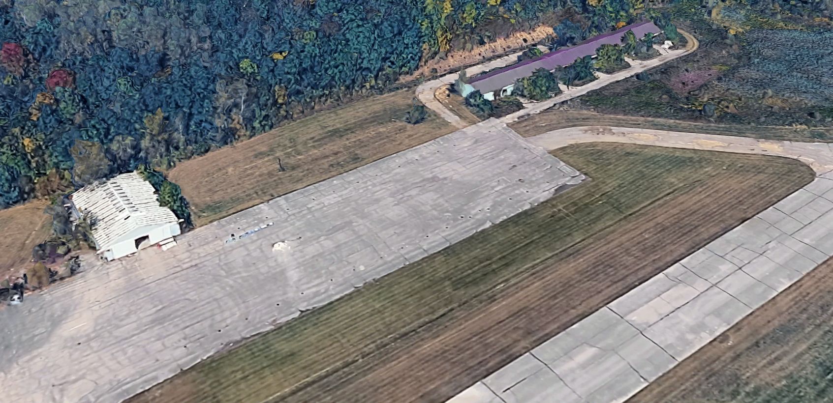
A 2026 3-D aerial image looking north at the former Bellefontaine Municipal Airport hangars.
Bellefontaine Municipal Airport is located southeast of the intersection of Route 68 & Twp Highway 57, 3 miles north-northeast of the town of Bellefontaine.
____________________________________________________
Darby Dan Airport (6I6 / 75OA), Galloway, Ohio
39.944, -83.204 (West of Columbus, OH)

Darby Dan Airport, as depicted on the December 1952 Cincinnati Sectional Chart.
Andrew Gabalski reported, “Darby Dan Airport was part of Darby Dan Farm, founded in 1935 by local businessman John Galbreath.
Named after his son, Daniel, and the Big Darby Creek that ran through the property, Darby Dan Farms became an elite horse racing & breeding facility, producing multiple Kentucky Derby winners.”
Darby Dan Airport was not yet depicted on a 1948 USGS aerial photo.
According to its FAA Airport/Facility Directory data, Darby Dan Airport was activated in January 1950.
However, Darby Dan Airport was not yet depicted on the July 1952 Cincinnati Sectional Chart.
The earliest depiction which has been located of Darby Dan Airport was on the December 1952 Cincinnati Sectional Chart.
It depicted Darby Dan as having a 4,000' paved runway.

The earliest photo which has been located of Darby Dan Airport was a 3/20/53 USGS aerial view.
It depicted a single unpaved east/west runway, with one hangar on the north side.
Andrew Gabalski reported, “As the farm grew, the Galbreaths hosted race teams & celebrities from all over the world, all of which eventually lead to the establishment of the airport.”

The earliest topo map depiction which has been located of Darby Dan Airport was on the 1956 USGS topo map.
It depicted a single unpaved east/west runway, labeled generically “Private Landing Strip”.
A 1957 aerial view showed that Darby Dan had gained a paved runway at some point between 1953-57,
and one light twin-engine aircraft was parked on the ramp near the hangar.

A 1959 photo of a horse being offloaded from a Global Airways Douglas C-54B at Darby Dan Airport (courtesy of Thomas Gabalski).

The July 1960 Cincinnati Sectional Chart showed Darby Dan Airport's runway had been somewhat lengthened, to a 4,900' paved east/west runway.
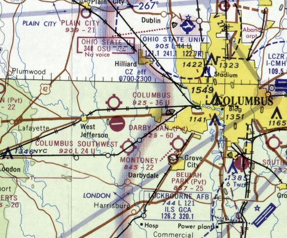
The February 1969 Cincinnati Sectional Chart showed Darby Dan Airport's runway had been lengthened again, to a 6,000' paved east/west runway.
Andrew Gabalski reported, “With a single hangar, the airport was host to numerous aircraft over the years.
The Galbreaths operated an Aero Commander 1121 Jet Commander & an IAI 1124 Westwind.”

A 1974 photo (courtesy of Andrew Gabalski) of Princess Margaret deplaning at Darby Dan Airport, with the Galbreath’s Westwind is visible in the background.
Andrew Gabalski reported of Darby Dan Airport, “Also noteworthy, was a visit by former President Gerald Ford in 1983.”

The 1995 USGS topo map depicted Darby Dan Airport's runway having been lengthened to the east, labeled “Private Darby Dan Airstrip”.

A pre-2024 aerial view looking east at Darby Dan Airport from a departing Cessna.

A pre-2024 aerial view looking east at Darby Dan Airport, with the Columbus skyline in the background.
According to its FAA Airport/Facility Directory data, for the year ending 6/12,07, Darby Dan Airport had 7 based aircraft, including 4 multi-engine aircraft.
It was said to conduct an average of 31 takeoffs or landings per day, a figure which seems possibly overly generous.
It was said to have a single 5,892' asphalt Runway 9/27, to be owned by Darby Dan Holdings, and managed by Bruce Goodman.

A 2010 aerial view of the Darby Dan Airport, showing a swept-wing business jet (a Gulfstream 200?) & 2 light single-engine aircraft.
Andrew Gabalski reported, “In the more recent years, Darby Dan was home to an aerial survey company [Midwest Aerial Photography], who I worked for as a pilot, for a short time.
We operated a variety of aircraft, including Cessna 206s & 310s, Piper Aztecs & Navajos, and an Aero Commander 500 Shrike.
Being a private airport, we had the ability to freely use the field for non-standard operations, including testing ground-based mobile radar systems, and hosting the Columbus Big Birds model aircraft club.
The company who built & tested the radar systems was STAR Dynamics of Hilliard, OH.
They tested numerous systems at Darby Dan over the years, but had primarily worked on their XSTAR system during my time, later demonstrating the system to representatives of the US DoD at the airport.”

A 9/22/17 photo (courtesy of Andrew Gabalski) of a Midwest Aerial Photography Aero Commander 500 Shrike in front of the Darby Dan Airport hangar.

A 10/13/17 photo (courtesy of Andrew Gabalski) of several Midwest Aerial Photography aircraft inside the Darby Dan Airport hangar.

A 4/26/18 photo (courtesy of Andrew Gabalski) of the Darby Dan Airport / Midwest Aerial Photography sign.

A circa 2017-2018 photo (courtesy of Andrew Gabalski) of aircraft of the Columbus Big Birds model aircraft club in front of the Darby Dan Airport hangar.

The last aeronautical chart depiction which has been located of Darby Dan Airport was on the November 2020 Cincinnati Sectional Chart.
It depicted Darby Dan as a private airfield having a single 5,9000' paved east/west runway.

A 2021 photo looking west along the Darby Dan Airport runway.

A 10/27/22 aerial view by Phil Brooks looking east at Darby Dan Airport, with the adjacent Darby Dan track in the foreground.

A 10/27/22 photo by Phil Brooks looking along the Darby Dan Airport runway.
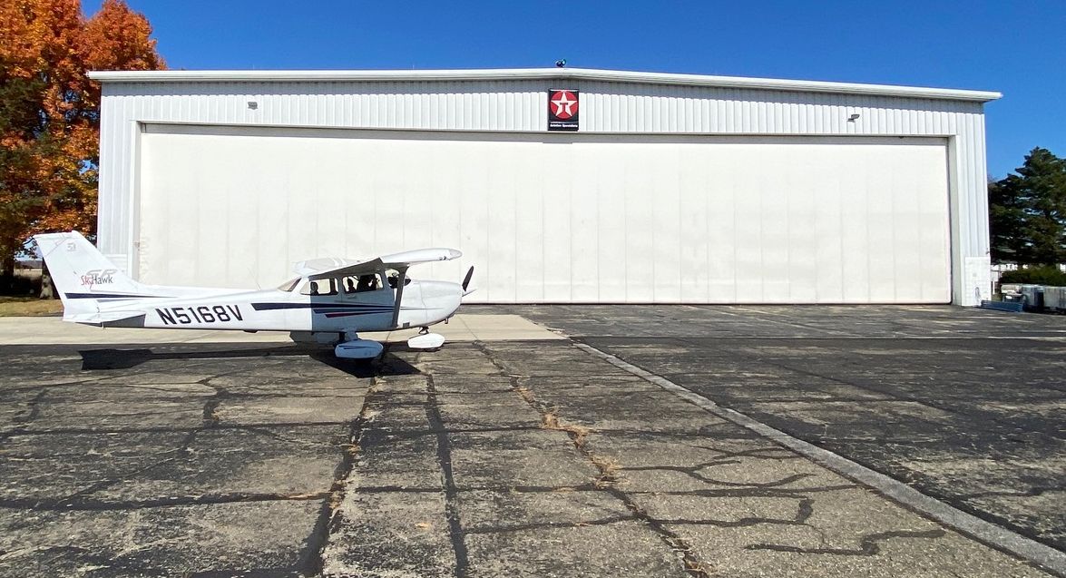
A 10/27/22 photo by Phil Brooks of a Cessna 172 in front of the Darby Dan Airport hangar.

A 10/27/22 photo by Phil Brooks of the sign warning of the “Attack Kitten” inside the Darby Dan Airport hangar.

The last photo which has been located showing an aircraft at Darby Dan Airport was a 2023 aerial view looking northwest, which showed 1 light single-engine aircraft parked on its ramp.
Andrew Gabalski reported, “My former survey company [Midwest Aerial Photography] was the sole user of the airport since the early 2000s.
The company merged with another survey company in 2023, and the decision was made to cease all operations at Darby Dan & relocate to the nearby Madison County Airport.
This left Darby with no regular operations, and presumably led Darby Dan Farm (who still owned the property) to develop it into a solar farm.
Darby Dan Airport as officially closed in February 2024.”

A 2024 aerial view looking northwest showed Darby Dan Airport remained intact, though devoid of aircraft.
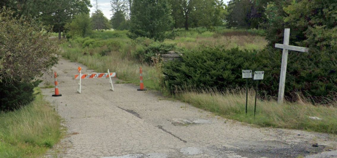
A sad 2023 photo looking southwest showed the Darby Dan Airport entrance blocked off, and the airport sign removed.
____________________________________________________
Josephinum Airfield, Worthington, Ohio
40.117, -83.013 (North of Columbus, OH)

Josephinum Airfield, as depicted on the May 1963 Cleveland Sectional Chart.
This small general aviation airfield was evidently established at some point between 1953-57, as it was not yet depicted on a 1953 aerial photo.
The earliest depiction which has been located of Josephinum Airfield was on a 1957 aerial photo,
which depicted a single grass east/west runway, with 1 T-hangar on the northwest side.
Bob Pautsch recalled, “As a kid growing up in Worthington [1957-71], I knew of an airport on North High Street (US23).
It intrigued me but I never went to it though we drove by it many times.
I think it was affiliated with the Josephinum College across the street.”
Josephinum Airfield was not yet depicted on the 1961 Cleveland Sectional Chart.
The earliest aeronautical chart depiction which has been located of Josephinum Airfield was on the May 1963 Cleveland Sectional Chart.
It depicted Josephinum Airfield as having a 2,900' unpaved runway.

The earliest photo which is available of Josephinum Airfield was a 5/1/63 USGS aerial view.
It depicted Josephinum Airfield as having a single east/west grass runway, with 1 light single-engine plane & 1 small hangar on the northwest side.

The earliest topo map depiction which has been located of Josephinum Airfield was on the 1965 USGS topo map.
It depicted a single upaved east/west runway, generically labeled “Landing Strip”, with a parking area & 1 small building on the northwest side.
The last photo which has been located showing planes at Josephinum Airfield was a 1966 aerial view.
It depicted 2 light single-engine planes on the northwest side, and a 2nd small hangar had been added at some point between 1963-66.
Andy Gelston recalled, “I lived just north this strip & would ride by it on the school bus 1970-72.
I always sat on the side of the bus that would be closest to it so I could see if there was any activity. There rarely was.
There was a building facing the road, on the north side of the runway, that had EAA Chapter XXX painted on it.
I'd stopped by on my bicycle a few times, but there was nobody around during my visits.
I believe the plane parked outside was a homebuilt & the hangar was used by the EAA members for aircraft building & meetings.”
A 1971 aerial photo showed Josephinum Airfield's runway & hangars remained intact, but no planes were visible.

The last aeronautical chart depiction which has been located of Josephinum Airfield was on the August 1976 Cincinnati Sectional Chart.
It depicted Josephinum Airfield as a private airfield having a 3,000' unpaved runway.
A 1980 aerial photo showed Josephinum Airfield's runway & hangars remained intact, but no planes were visible.
Josephinum Airfield was evidently closed (for reasons unknown) at some point between 1976-81,
as it was no longer depicted on the 1981 Cincinnati Sectional Chart.
A 1995 aerial photo showed several buildings had covered most of the Josephinum Airfield property.
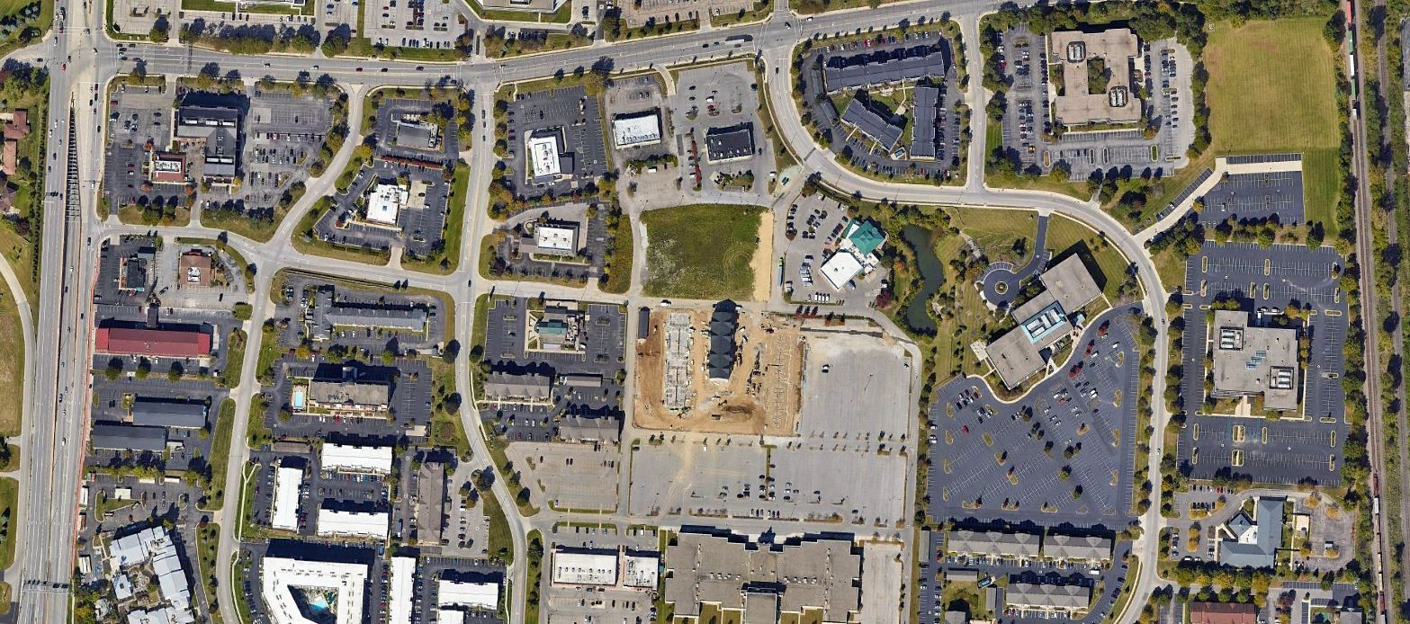
A 2022 aerial photo showed no trace remaining of Josephinum Airfield.
Thanks to Bob Pautsch for pointing out this airfield.
____________________________________________________
Price Airport / Price Field, Columbus, OH
39.92, -82.9 (Southeast of Downtown Columbus, OH)

Price Airport, as depicted on the June 1942 Huntington Sectional Chart.
Price Airport was apparently established at some point between 1941-42,
as it was not yet depicted on the October 1941 Huntington Sectional Chart.
The earliest depiction which has been located of Price Airport was on the June 1942 Huntington Sectional Chart.
It depicted Price as a commercial/municipal airport.

The earliest topo map depiction which has been located of Price Airport was on the 1943 USGS topo map.

The earliest photo which has been located of Price Field was a 9/28/43 aerial view looking north from the 1945 AAF Airfield Directory (courtesy of Scott Murdock).
It depicted Price Field as having an open grass landing area.
The 1945 AAF Airfield Directory (courtesy of Scott Murdock) described Price Field
as a 100 acre irregularly-shaped field having 4 sod runways, the longest being a 2,200' northeast/southwest strip.
The field was said to have a single 105' x 37' metal hangar, and to be owned & operated by private interests.
According to Wesley Conn, “Price Field was an 88 acre square field. It provided flight training under the GI Bill.
They had grass runways in the summer & dirt in the winter. They had corner-to-corner runways.
The southeast was a little further north to clear the hangar. They also had east/west & north/south [runways].
I soloed on the north heading which had electric lines on the approach.”
Wesley continued, “I was just a kid hanging around the airport all day, almost every day.
W.W. Cohen was the manager. I think he leased the property from the owner,
who lived in a house in the woods on the southwest corner of the property.
They had 6 or 8 Aeronca Champions, a J-3, a J-4, 1941 Bellanca Cruiser with a 90 horse Le Blond radial engine.
Chief Pilot was Harry Jorden. He also taught the ground school.
Another instructor was Ken Prutsman, and there was Col. Frank Ward, he was Commanding Officer of the air wing of the OH National Guard.
He couldn’t get enough flying on duty so he worked as flight instructor in his off time.”
Wesley continued, “The G.W. Holms Company in Columbus bought & reconditioned a few N3Ns & kept of them at Price Dield.
Dail Matheni got his flight training there & later become the company pilot for Holmes.
Zack Mosley, creator of Smiling Jack comics, tied down his purple SR-7 there for a few weeks. This was quite a spectator draw.
A couple of years went buy & I got hired as a line boy at 35 cents an hour.
Charley Britt was the chief mechanic & the A&E. I finally started my flight training.
The airplane cost me $3/hour, and the instructor $2/hr.
Col. Ward was my instructor & he wouldn’t take the $2 instructor's fee. All the money I made went to flying.
I do not have pictures of all this – I wish I did, but what teenager back in those days would be doing with a camera?”

The 1953 Huntington Sectional Chart depicted Price Field as having a 2,000' unpaved runway.

A 3/1/53 USGS aerial view showed Price Field to have 3 grass runways, with a small building & 10 light planes on the southeast side.

The 1955 USGS topo map showed Price Field to have 3 unpaved runways & several small buildings along the south side.
Susan Rodda recalled, “My father, Eugene 'Whitey' Jost, built a hangar at the opposite end of the field from the original hangar at Price Field in the late 1950s
to take over the maintenance, repair, rebuilding & inspection services from the Fixed Base Operator of the field at that time.
He became the FBO of the entire field around 1960 as Jost Aero Services.
Also around that time, the services for the Lockbourne Flying Club was moved to Price Field.
He used Cessna aircraft to provide flying lessons, rentals & rides to the public.
Within a couple of years he added a Stearman biplane he had rebuilt to tow banners for advertising for local businesses & for rides for the public.
For a couple years Geraldine Mock became a partner & the business became Jost & Mock Aero Services.
During that time, he fitted out one of the planes for her solo flight around the world.”
In 1961 Jerry Mock became the first woman licensed by OH to manage an airport, Price Field, a job she held for about a year.
On Sundays she was there alone, which meant fueling airplanes, tying them down, and even doing despised household chores like making coffee.
“The male instructors did not like a woman telling them what to do”, Mock recalled. “I did not worry about it & ignored them.”
Susan Rodda recalled, “Sometime after that, he became sole operator again & replaced his Cessnas with Pipers.
He had at least one twin-engine part of that time.”

The last photo which is available showing Price Field still in operation was a 5/6/63 USGS aerial view.
The east/west runway appeared more distinct than the others, and there were several dozen light aircraft on the southeast side.
A 2nd hangar (on the middle of the south side of the field) had been added at some point between 1953-63.

The last aeronautical chart depiction which has been located of Price Field
was on the August 1965 Huntington Sectional Chart (courtesy of Ron Kunse).
It depicted Price Field as having a 2,200' paved east/west runway.
Susan Rodda recalled, “Around 1965 [Eugene 'Whitey' Jost] moved the entire operation [Jost Aero Services] to Port Columbus, leaving Price Field.”
A 1971 aerial view depicted 19 light aircraft on the southeast side of Price Field.

The last photo which has been located showing Price Field still in operation was a 1972-73 photo by Tom Williams of a Piper J3 Cub.
Tom recalled, “The most fun airplane to fly was this J3 Cub.”
Tom Williams recalled, “Price Field... I got my Private Pilot License at this little field of potholes & gravel (smile).
We used the east/west runway 95% of the time.
Bob Boston was the Operator & my main Flight Instructor. A tough Instructor, but his training saved my life an a few occasions.
I have fond memories flying at Price Field. Many a Pilot got their license there.
One day I arrived for my one hour lesson from Bob.
His wife said that he was in the hangar & that I should preflight a Cessna 150 & that he would be with me soon.
Well, I finished my preflight & was sitting there waiting. Suddenly Bob came running past me into the office.
I thought that there was a fire, so I ran into the office. There they were (him & his wife) trying to catch a wild raccoon, swamping about.
The raccoon was in the ceiling & was a little too heavy for the thin panels & fell through on top of the desk where his wife was working.
I can’t remember how, but they caught him & threw him into the bushes.
Laugh - training went well that day, just the same.”
Tom continued, “Due to complaints of the new homeowners around Price Field the Fixed Base Operator was closed down
and my friend Eric Weber & I ferried the remaining aircraft down to Lancaster Airport.
Price Field was evidently closed at some point between 1972-76,
as it was no longer depicted on the August 1976 Cincinnati Sectional Chart (courtesy of Mitchell Hymowitz).

The last depiction which has been located showing Price Field was on the 1985 USGS topo map.
It depicted Price Field as having 3 unpaved runways & several small buildings along the south side.
The 1994 USGS topo map no longer depicted Price Field, just a clearing,
but the 2 hangars remained depicted on the southeast side.
A 1994 USGS aerial photo depicted 2 hangars remaining on the south & southeast side.
A 2002 aerial photo showed the hangar on the southeast side had been removed at some point between 1994-2002.

A 5/28/10 aerial view showed the site of Price Field remained clear, with 1 hangar remaining on the south side.

A circa 2011 aerial view looking west at a hangar which remains standing along the south side of the Price Field site.
The hangar on the southeast side had been removed.

A circa 2011 aerial view looking north at the remains of the ramp & the hangar foundation on the southeast side of the Price Field site.
Wesley Conn reported in 2013, “The [southeast] hangar is gone now but looking close,
the concrete floor can still be seen as well as the round circle of the gas island.”

An October 2022 photo looking northwest at a hangar which remains standing along the south side of the Price Field site.
The site of Price Field is located northwest of the intersection of Refugee Road & Courtright Road.
____________________________________________________
(Original) Springfield Municipal Airport, Springfield, OH
39.9, -83.73 (Northeast of Dayton, OH)

Springfield Airport, as depicted on the 1928 Air Navigation Map (courtesy of Chris Kennedy).
The original airport for the town of Springfield was located approximately 4.5 miles southeast of the town.
The date of construction of the original Springfield Airport has not been determined.
The earliest depiction of the field which has been located
was on the 1928 Air Navigation Map (courtesy of Chris Kennedy).

The 1934 Air Pilots Register (courtesy of Michael Banks)
depicted Springfield as having 2 macadam runways:
a 2,850' northeast/southwest strip & a 2,450' east/west strip.
A number of buildings were depicted on the northeast corner of the field.

The February 1934 Huntington Sectional Chart depicted Springfield Municipal Airport as a commercial/municipal airport.

The earliest photo which has been located of Springfield Municipal Airport
was an undated aerial view in The Airport Directory Company's 1937 Airport Directory (courtesy of Bob Rambo).
The directory depicted Springfield Municipal as having 2 macadam runways:
a 2,660' northeast/southwest strip & a 2,375' east/west strip.
Several buildings were located east of the runway intersection.
The April 1944 US Army/Navy Directory of Airfields (courtesy of Ken Mercer) described Springfield Airport as having a 2,700' runway.
The field was said to conduct "Extensive training."

A circa 1943-45 aerial view looking north from the 1945 AAF Airfield Directory (courtesy of Scott Murdock)
depicted Springfield Municipal Airport as having 2 grass runways, with 2 hangars on the east side.
The 1945 AAF Airfield Directory (courtesy of Scott Murdock) described Springfield Municipal Airport
as a 126 acre irregularly-shaped field having 2 gravel runways, the longest being a 2,700' northeast/southwest strip.
The field was said to have 3 hangars, the largest being a 80' x 60' metal structure.
Springfield Municipal was described as being owned by the City of Springfield & operated by private interests.
According to Durward Lewis, “There was a great deal of flying activity at the old airport,
as the operator ran a CPT [Civilian Pilot Training] program during the war.”

The last photo to be located showing Springfield Municipal Airport in operation was an 8/25/46 aerial view (from the ODOT archives, courtesy of Dennis Thompson).
It depicted Springfield Municipal as having 2 paved runways, with 2 hangars & 10 light single-engine aircraft on the east side.
Note that a trap shooting range was located adjacent to the south side of the southwest runway end.

The last depiction which has been located of the original Springfield Municipal Airport was on the October 1947 Huntington Sectional Chart.
The original Springfield Municipal Airport was apparently abandoned at some point between 1947-48,
as it was no longer depicted on the October 1948 Huntington Sectional Chart.
It instead depicted a new Springfield Airport on the southwest side of the town, which was built with much longer runways.
The original Springfield Airport property (to the southeast of the town) was reused as a fairgrounds.
Phil Brust recalled, “When I was five (1951), my parents took me to a circus at the fairgrounds.
There was an abandoned B-25 or B-26 still on the property
and my father boosted me up into the cockpit (tragic how surplus equipment was treated back then).
So the airport had been converted to fairgrounds by 1951.”
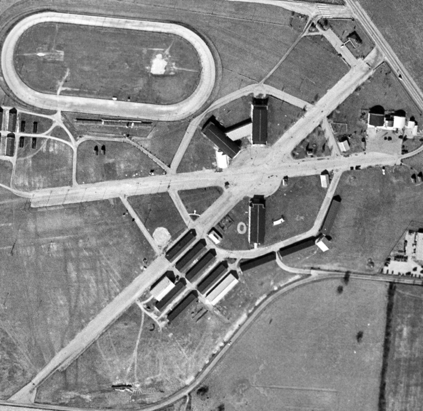
A 1/19/59 USGS aerial view of the site of the original Springfield Municipal Airport showed the 2 paved former runways were still completely intact,
and at least 2 original hangars (the arch-roofed buildings in the northeast corner of the photo) still remained standing.
A large number of more recent buildings had been constructed for the fairgrounds around the runways (including one built over the runway).
The 1962 USGS topo map labeled the site of the airport as the Clark County Fairgrounds.

The former runways of the Springfield Airport were still quite recognizable on the 1995 USGS topo map.
Dave Noordeloos reported in 2004, "I was on a trip in Springfield a few weeks ago
and stumbled on the Clark County Fairgrounds while on the way back to the highway.
I noticed some old hangars & a very wide concourse for the fairgrounds & pulled in."
Durward Lewis reported in 2005, “The runways are still there.”

A circa 2006 aerial view looking north at the 2 hangars which remain at the site of the original Springfield Municipal Airport.
The pavement of the 2 former runways is also visible at the top & bottom.

A July 2011 photo by Tom Townsend looking west along the former Springfield Municipal Airport runway.
Tom reported, “It is now the site of the Clark County Fairgrounds.
I looked up & down both runways for any sign of light fixtures, but if they were there, they've long been paved over.
The runways are both still there in their entirety, but used for parking, the midway, and a building has been built on one of them.”
Chris Mokren reported in 2014, “They are in the process of tearing down the hangars at the original Springfield airport.
The one on the right is now completely gone & they have started on the left one.
The plan, from what I have heard, is they want to build a hotel on that site.”

A March 2014 photo by Chris Mrocken of the demolition of the original Springfield Municipal Airport hangars.
Chris observed, “All that is left is the concrete floor.”

A 2016 aerial view looking north at the site of the original Springfield Municipal Airport, showing the very recognizable runways which remain.

A March 2022 photo by looking northeast along the former Springfield Municipal Airport runway, now reused by the fairgrounds.
The site of the original Springfield Municipal Airport is located west of the intersection of Interstate 70 & Route 41.
____________________________________________________
Or if you prefer to contact me directly concerning a contribution (for a mailing address to send a check),
please contact me at: paulandterryfreeman@gmail.com
If you enjoy this web site, please support it with a financial contribution.
____________________________________________________
This site covers airfields in all 50 states.