
Abandoned & Little-Known Airfields:
Northwestern Oregon
© 2002, © 2026 by Paul Freeman. Revised 7/3/26.
This site covers airfields in all 50 states: Click here for the site's main menu.
____________________________________________________
Please consider a financial contribution to support the continued growth & operation of this site.
Bernard Field (revised 7/3/26) - Corvallis Airport (original location) (added 3/12/22) - Corvallis Junction Airport (added 1/16/22) - Dallas Airport / Cards Airpark (revised 3/23/25)
Green River Airfield (revised 12/31/22) - Langmack Field (revised 4/17/20) - Lyndon Airport (added 3/12/22)
Tillamook Municipal Airport / Tillamook American Legion Airport / Tillamook Coastway #1 Airport (added 8/30/20) - Tongue Point NAS (revised 2/15/26)
____________________________________________________
Corvallis Airport (original location), Corvallis, OR
44.58, -123.263 (Southwest of Portland, OR)
Jonathan Westerling reported, “Prior to WW2, Dick Lyndon built no less than 3 airfields in succession around Corvallis during the 1930s (according to information from OSU Special Collections).”
The date of construction of the original Corvallis Airport (to the north of the town) has not been determined.
The earliest depiction which has been located of Corvallis Airport was a 1930 photo looking west at a crowd, several biplanes, and hangars (from OR State University, courtesy of Lee Corbin).
According to the caption, the road behind the hangars was Grant Street. The field was bordered on the east side by a dirt road which is now Northwest Highland Avenue.
The field was operated by Albert Parmenter & Dick Lyndon.
The airplane on the right was a 1929 Swallow owned by Joe Chamberlin, Slats Gill, and Roy Getz.
The middle plane was a 1929 American Eagle, and the plane in the foreground was a 1925 WACO "9" powered by a 90 H.P. OX-5 engine.
According to the OR State University, the original Corvallis Airport (to the north of the town) “was abandoned in 1930 when Parmenter moved to Eugene.
Lyndon started another airport on South 3rd Street at what is now Goodnight Avenue.”

The earliest aeronautical chart depiction which has been located of Corvallis Airport was on the June 1934 Portland Sectional Chart (courtesy of Lee Corbin).
It depicted Corvallis Airport as an auxiliary airfield located to the north of the town.
The original Corvallis Airport was no longer depicted on the April 1935 Portland Sectional Chart or the 1937 USGS topo map.
A 1954 aerial photo showed no trace of the original Corvallis Airport.

A 2020 aerial view showed no trace remaining of the original Corvallis Airport.
Thanks to Lee Corbin for pointing out this airfield.
____________________________________________________
44.537, -123.267 (Southwest of Portland, OR)
Lyndon Airport, as depicted on the June 1934 Portland Sectional Chart (courtesy of Lee Corbin).
Jonathan Westerling reported, “Prior to WW2, Dick Lyndon built no less than 3 airfields in succession around Corvallis during the 1930s (according to information from OSU Special Collections).”
According to the OR State University, the original Corvallis Airport (to the north of the town) “was abandoned in 1930 when Albert Parmenter moved to Eugene.
Dick Lyndon started another airport on South 3rd Street at what is now Goodnight Avenue.”
The earliest depiction which has been located of Lyndon Airport was on the June 1934 Portland Sectional Chart (courtesy of Lee Corbin).
It depicted Lyndon Airport as a commercial/municipal airport located south/southeast of the town.
Lyndon Airport was not depicted on the 1937 USGS topo map.

According to the caption, the airplane 2nd from left was a Rearwing Sportster 942, the next-to-last plane was a 1936 Alexander Eaglerock, and the aircraft at right was a Fairchild 24.

The last aeronautical chart depiction which has been located of Lyndon Airport was on the July 1942 Portland Sectional Chart.
It depicted Lyndon Airport as a commercial/municipal airport.
According to the OR State University, Lyndon Airfield was located west of Highway 99 West on Herbert Avenue, and was operated by Dick Lyndon (of Lyndon Airways).
It was abandoned in 1942.
Lyndon Airport was no longer depicted on the or the 1942 USGS topo map or the April 1944 Portland Sectional Chart,
or listed in the 1945 AAF Airfield Directory (courtesy of Scott Murdock).
A 1954 aerial photo showed no the remains of what may have been an unpaved northeast/southwest runway at the site of Lyndon Airport.

A 2020 aerial view showed no trace remaining of Lyndon Airport.
Thanks to Lee Corbin for pointing out this airfield.
____________________________________________________
Corvallis Junction Airport, Corvallis, OR
44.58, -123.255 (Southwest of Portland, OR)

Corvallis Junction Airport, as depicted on the October 1946 Portland Sectional Chart (courtesy of Jonathan Westerling).
Photo of the airport while in use has not been located.
Jonathan Westerling reported, “The Corvallis Junction Airport was apparently the result of a combination of postwar aviation excitement combined with the short-lived need for a public airfield.
Prior to WW2, Dick Lyndon built no less than 3 airfields in succession around Corvallis during the 1930s (according to information from OSU Special Collections).
The last of these was closed during WW2, and the Army built a significant military airfield south of town.
Eventually this military airfield was offered to the City as its municipal airfield, however before this occurred, a 2nd public airfield was built just east of downtown to serve as a commercial airport.”
Corvallis Junction Airport (on the northeast side of the town) was not yet listed in the 1945 AAF Airfield Directory (courtesy of Scott Murdock)
nor depicted on the April 1946 Portland Sectional Chart.
The earliest depiction which has been located of Corvallis Junction Airport was on the October 1946 Portland Sectional Chart (courtesy of Jonathan Westerling).
It depicted Corvallis Junction Airport as having a 2,000' unpaved runway.

The 1946 Airman's Guide (courtesy of Jonathan Westerling) depicted Corvallis Junction Airport as having a 2,000' runway & fuel, but no aircraft storage.
The 1947 Decker's Pacific Guide listed Corvallis Junction Airport as using right traffic when landing north (to avoid overflying the downtown area).
The 1948 Haire Airport Guide listed the Corvallis Junction Airport as having gained an administration building, having facilities for major AE repairs, and Joseph Chapman as the manager.

The 1949 OR Airport Directory (courtesy of Jonathan Westerling) showed Corvallis Junction Airport as having a traffic pattern only on the east side (avoiding housing on the other side of the railroad),
and listed the manager as Harry Harris.
The 1950 Airman's Guide listed Corvallis Junction Airport as inactive, which would indicate that the Corvallis Army Airfield had been fully converted to municipal use by this time.

The only topo map depiction which has been located of Corvallis Junction Airport was on the 1953 USGS topo map.

The last depiction which has been located of Corvallis Junction Airport was on the April 1953 Portland Sectional Chart (courtesy of Jonathan Westerling).
It depicted the runway length as having shrunken to a mere 1,400'.
Corvallis Junction Airport was no longer depicted on the October 1953 Portland Sectional Chart.
A 1954 aerial photo showed the Corvallis Junction Airport runway as remaining clear, but there was no indication of recent aviation use.
Corvallis Junction Airport was no longer depicted on the 1956 USGS topo map.

A 2020 aerial view looking northwest showed the Corvallis Junction Airport runway remained mostly intact.
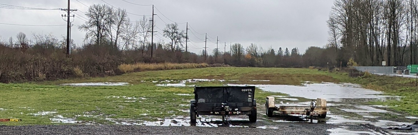
A 12/19/21 photo by Jonathan Westerling looking northeast along the remains of the Corvallis Junction Airport runway.
Jonathan reported, “Astonishingly the original turf runway is still clear & undeveloped 70 years later. It is municipally owned; kept clear but used by the DPW for storage.”
Thanks to Jonathan Westerling for pointing out this airfield.
____________________________________________________
Tillamook Municipal Airport / Tillamook American Legion Airport / Coastway Airport /
Coastway School of Aeronautics Airport / Tillamook County Municipal Airport /
Tillamook Coastway #1 Airport, Tillamook, OR
45.454, -123.809 (South of Portland, OR)

Tillamook Municipal Airport, as depicted on the 1929 Landing Fields of the Pacific Northwest (courtesy of Jonathan Westerling).
Photo of the airport while in use has not been located.
This little airport went through a succession of at least 6 different names over 36 years.
The date of establishment of Tillamook Airport has not been determined.
The earliest reference which has been located of Tillamook Airport was in a 1921 Aeronautical Bulletin.
It described an emergency airfield with two 1,600' runways at the County Fairgrounds.
The earliest depiction which has been located of Tillamook Airport was on the 1929 Landing Fields of the Pacific Northwest.
The 1931 Landing Fields of the Pacific Northwest described Tillamook Municipal Airport as being operated by the American Legion Post.
It was said to have two 1,500' gravel runways.
The 1932 Aeronautical Bulletin described Tillamook American Legion Airport as having one 1,800' gravel runway.
The 1936 Aeronautical Bulletin described Tillamook American Legion Airport as having one 3,000' sod northwest/southeast runway.
Tillmook Airport was not listed in the 1945 AAF Airfield Directory (courtesy of Scott Murdock).

The 1946 Flight Chart (courtesy of Jonathan Westerling) depicted Tillamook Coastway Airport as an auxiliary airfield.
Jonathan Westerling reported, “During WWII the Navy built a substantial airfield south of the city (with 2 blimp hangars).
After the war, the Navy retained its airbase for a few years, so the Municipal Airport at the fairgrounds continued to be used as the 'public' airport for civilian aviation.
A company called the 'Coastway School of Aeronautics' was formed in Tillamook & the County airfield adopted the school's name.
By 1948, the Navy had sold its larger airfield to the city (not the county).
Over the next several years, all aviation operations transitioned to the city's larger airfield

The 1948 USGS topo map depicted Tillamook Coastway #1 Airport as well as the Tillamook Coastway #2 Airport (the larger former Navy airfield to the south).

The 1949 OR Airport Directory (courtesy of Jonathan Westerling) depicted Tillamook County Airport as having a single 2,600' turfed & gravel northwest/southeast runway.
The manager was listed as W.J. Herd.

The last photo which has been located of Tillamook Coastway #1 Airport was a 7/31/53 USGS aerial view.
It depicted Tillamook Coastway #1 Airport as having a single unpaved northwest/southeast runway adjacent to the Tillamook Fairgrounds.
There were no aircraft visible on the field.

The 1955 USGS topo map depicted a single unpaved northwest/southeast runway adjacent to the Tillamook Fairgrounds, generically labeled as “Airport”.

The last aeronautical chart depiction which has been located of Tillamook Coastway #1 Airport was on the Portland 1957 Sectional Chart (courtesy of Jonathan Westerling).
It depicted Tillamook Coastway #1 Airport as having a 2,100' unpaved runway.
Tillamook Coastway #1 Airport was evidently closed at some point between 1957-58,
as it was no longer depicted on the 1958 Portland Sectional Chart.
A 1982 aerial view showed a clearing was still recognizable on the south side of the fairgrounds which corresponded to the former northwest/southeast runway.

A 2017 aerial view showed a clearing was still recognizable on the south side of the fairgrounds which corresponded to the former northwest/southeast runway.
Thanks to Jonathan Westerling for pointing out this airfield.
____________________________________________________
Dallas Airport / Cards Airpark, Dallas, OR
44.932, -123.314 (Southwest of Portland, OR)

Dallas Airport, as depicted on the April 1946 Portland Sectional Chart.
The Dallas Airport was not yet depicted on the April 1945 Portland Sectional Chart.
According to the article “Planes to fly again at Card's Airpark on Saturday” by Joelene Guzman in the 7/15/15 Polk County Itemizer-Observer,
“In 1946, the Card family purchased 50 acres of land for what would become Card’s Airpark.
Joe & Betty & a small crew built the hangar by hand.”
The earliest depiction which has been located of Dallas Airport was on the April 1946 Portland Sectional Chart.
It depicted Dallas as an auxiliary airfield.
The March 1949 Portland Sectional Chart (courtesy of Chuck Jarecki) depicted Dallas Airport as having a mere 1,900' unpaved runway.

Dallas Airport, as depicted on the 1953 USGS topo map.

The earliest photo which has been located of Cards Airpark was an August 1955 aerial view.
It depicted Cards Airpark as having a single northeast/southwest runway, with a hangar on the east side.
No aircraft were visible on the field.

An undated photo of Cards Airpark owners/operators Joe & Betty Card, in front of a Waco UPF-7 biplane presumably at their airpark.
Jim Grant reported in 2016, “N29986 is currently registered to a Marc Roberts of Thomasville PA.”
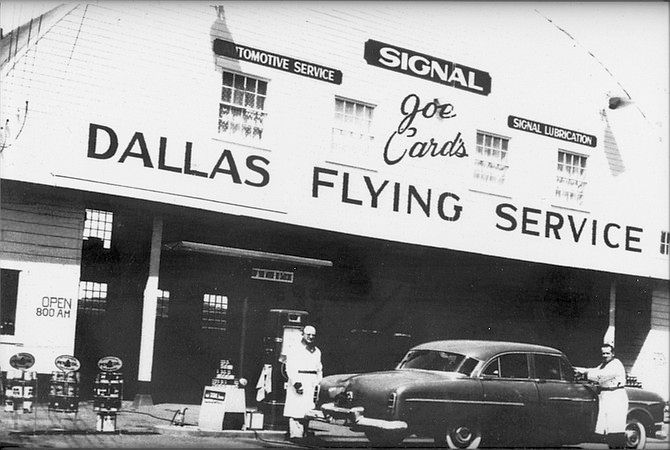
An undated photo of the Dallas Flying Service hangar at Card's Airpark, showing how they also performed automotive service to help support the airpark.
Diane Weaver & Bette Jo Lawson, the daughters of Joe & Betty Card, have fond memories of the airpark’s heyday.
“My sister Bette Jo & I grew up walking around the airplanes & playing in the crashed airplanes,” Weaver recalled.
“There was always something to talk about at school because there was always something special that happened, a big, huge plane (landing at the airpark),” Weaver said.
For many in Dallas at the time, Card’s Airpark went by another name: the Dallas Airport.
She said the airpark was used for fly-in events, circuses, drag racing, and even a race track was built on site.
Weaver said that track was reportedly the “fastest modified hard-top track in the Northwest.”
“He (Joe) wanted it to be like a family affair. We had picnic tables all over,” Weaver said. “There was always a lot of activity.”
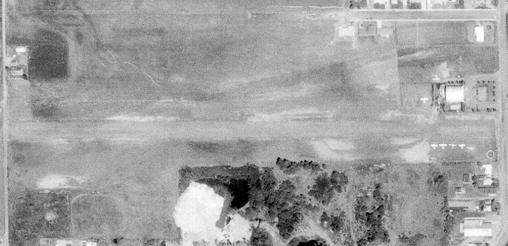
A May 1972 aerial view depicted Cards Airpark presumably at its zenith of popularity,
with a total of 6 light single-engine aircraft parked near the hangar on the east side.
Note that the northeast/southwest runway seen in the 1955 photo had evidently been replaced with an unpaved east/west runway.

The 1974 USGS topo map depicted Cards Air Park as having an unpaved east/west runway.
According to the article “Planes to fly again at Card's Airpark on Saturday” by Joelene Guzman in the 7/15/15 Polk County Itemizer-Observer,
Joe Card died in 1991, and “Card’s Airpark... closed in 1993.”
“It was pretty emotional for my mom to close it because it had meant so much to my dad - and her - but especially my dad,” Diane Weaver said.
“It was very traumatic for me when we closed it because it had been a daily part of my life. … I think it’s real special.”

The last aeronautical chart depiction which has been located of Cards Airpark was on the January 1994 Seattle Sectional Chart (courtesy of Ron Plante).
It depicted Cards as a private airfield having a 2,100' unpaved runway.

A 1994 USGS aerial photo depicted Cards Airpark a year after its closure, but still remaining intact.
The remains of a segmented circle were visible on the southeast side of the site.

A circa 2011-2016 photo of the Cards Airpark hangar.
According to the article “Planes to fly again at Card's Airpark on Saturday” by Joelene Guzman in the 7/15/15 Polk County Itemizer-Observer,
“Most of the land was sold & is now occupied by Dallas Retirement Village, Safeway, Goodwill and residential homes.
All that remains is a small strip of land & the hangar, recently restored by Weaver & her sister Bette Jo Lawson, at the bottom of the hill on Orchard Drive in Dallas.”
“My sister & I didn’t want to let the building go,” Weaver said. “I think it looks pretty good now. It has all new siding & some of the trusses were rebuilt.”
They added a sign reading “Card’s Airpark: In loving memory of Joe & Betty Card.”
The article continued, “Saturday Dallas remote control plane group Dallas Wingdingers RC Club will rededicate what remains of the airpark, located at the corner of Orchard Drive & Card Avenue.
The event will include the first takeoff of a plane - albeit remote control - from the airpark in years.
Today, the hangar is like brand new after a multiple-year restoration by Diane Weaver & Bette Jo Lawson, the daughters of Joe and Betty Card.
Weaver said talk of a rededication began after a club member asked her if she had any plane artifacts from the time the airpark was open.
She didn’t have much, but she did have an unfinished model airplane she wanted to have completed.
Club members took on the task, finishing the plane & painting 'Wing Walking with Betty' across the wingspan in honor of Weaver’s mother,
who wrote a column of the same name for the Polk County Itemizer-Observer when the airpark was still open.
For Lawson & Weaver, Saturday’s rededication will honor the years of effort their parents put into maintaining the airpark in Dallas.”

A 2015 photo of the newly-restored Cards Airpark hangar.

A 2023 aerial view showed houses having covered the majority of the Cards Airpark site, but the former hangar remained intact on the east side.

A 2024 photo looking northwest at the former hangar still bearing the “Cards Airpark” sign.
The site of Cards Airpark is located east of Northwest Card Avenue, appropriately enough.
____________________________________________________
Green River Airfield, Sweet Home, OR
44.41, -122.69 (South of Portland, OR)

The Green River Airfield, as depicted on the 1984 USGS topo map.
According to Larry Nunn, “Green River Airfield... was the private airstrip of Skip Stock.
It was located on the property of the Stock family lumber business.”
Green River Airfield may have been established at some point between 1983-82,
as it was not yet depicted on the 1983 USGS topo map.
The earliest depiction which has been located of the Green River Airfield was a 1982 aerial photo.
It depicted a single unpaved east/west runway.
The earliest depiction which is available of the Green River Airfield was on the 1984 USGS topo map.
It depicted a 4,200' unpaved east/west runway, labeled simply as “Landing Strip”.

The earliest photo which has been located of the Green River Airfield was a 1994 USGS aerial view looking northwest.
This is also the only photo which has been located showing an aircraft on the field: 1 single-engine light aircraft near the hangars on the northeast side.
Green River Airfield was evidently closed (for reasons unknown) at some point between 1994-98,
as it was not depicted at all on the 1998 Portland Sectional Chart (courtesy of Jonathan Westerling).

A 2014 aerial view looking northwest showed Green River Airfield's runway & hangars remained intact, but without any sign of recent aviation usage.
As of 2015, street maps label the former hangars as Riverside Christian Church.

A September 2022 photo looking south at the former Green River Airfield hangars.
Green River Airfield is located east of the intersection of Green River Road & Clark Road.
Thanks to Gary Alexander for pointing out this airfield.
____________________________________________________
Langmack Field, Sweet Home, OR
44.4, -122.685 (South of Portland, OR)

Langmack Field, as depicted on the April 1944 Portland Sectional Chart.
According to Jonathan Westerling, “The first airport in the little logging town of Sweet Home, Oregon was built by the town’s physician.
Robert 'Doc' Langmack PhD practiced medicine in Sweet Home for 50 years beginning in 1931, and also founded the local hospital.
While Dr. Langmack will be remembered for his medical practice
he should also be remembered for his love of flying which he considered his second passion in life next to medicine.”
Jonathan continued, “Langmack Field was originally built in the early 1940s.”
According to an undated article on the airport by Martha Steinbacher,
“By June of 1940 he had a field & a hangar completed.
The first hangar, a one-place structure, stood by itself on the south side of the field & bore the name 'LANGMACK FIELD' in large black letters.
Frequently the sound of the 'putt putt' of the mighty little 65 horse powered Continental broke the silence of the community as 'Doc' went up for a flight.
The next year World War II came & all civilian flying was banned from this area.
Not even Doctor Langmack's little Taylorcraft was allowed to fly.
The original hangar was moved to the north side of the field & joined by 3 more hangars; two 3-place hangars & one 9-place hangar plus an office.”
Langmack Field was not yet depicted on the July 1942 Portland Sectional Chart.
The earliest depiction which has been located of Langmack Field was on the April 1944 Portland Sectional Chart.
It depicted Langmack as an auxiliary airfield.
Langmack Field was not yet listed in the 1945 AAF Airfield Directory (courtesy of Scott Murdock).
According to “Sweet Home in Linn County: New Life, New Land” by Martha Steinbacher,
Dr Landmack “made it a practice to fly over the countryside every morning watching for a white sheet placed on the ground in front of a house,
a signal that someone in that home needed his help.”

The earliest photo which has been located of Langmack Field was a late 1940s aerial view (courtesy of the East Linn Museum via Gayle Gregory).
It depicted Langmack as having a single grass east/west runway, with homes & small buildings on the north & south sides.

Langmack Field, as depicted in the 1949 OR Airport Directory (courtesy of Jonathan Westerling).
According to Jonathan, “The Directory depicted Langmack Airfield (perhaps optimistically) as having a 3,200' x 400' East/West sod & gravel runway.
The approach from the east was listed as 'blocked' by a 175’ hill in the approach.”
According to Jonathan Westerling, “Eventually the airport grew to include 3 large hangars & a runway used by many local private pilots.
The hangars were located on the north side of airport road & the runway was located on the south side.
This meant that the planes would have to look both ways before crossing Airport Road to taxi onto the runway.”
According to the book “Sweet Home’s Good Old Days” by Mona Waibel,
Larry Swain “owned & flew several different planes out of Langmack Airport after returning from the Navy.
One time he took off at dusk, there were no field lights, so he turned the hangar lights on as landing lights.
Someone unknowingly turned them off.
Landing after dark without those lights made landing a bit difficult.
Locals recall that an informal function of the airport was as a favorite 'necking' spot for high school students!”

An undated photo of 2 taildraggers in front of hangars at Langmack Field from a 1950 newspaper article (courtesy of the East Linn Museum via Gayle Gregory).
According to Jonathan Westerling, the newspaper article reported “the field was at that time home to 26 airplanes.”

The 1951 USGS topo map depicted Langmack Field as having a single east/west runway.
According to the book “Sweet Home’s Good Old Days” by Mona Waibel”,
another notable pilot at the airport was Arlen Moore.
“Doc hired him to run the airport.
Arlen earned his pilot license in 1952, flying his Porterfield.
He stayed for 37 years doing this job from 1953-90.
He & wife Gerri lived on Airport Road with their 2 children.
His job was selling gas & oil to pilots, repairing simple things on planes, and mowing the runway with Ed Russell to keep the planes using Langmack Airport.
This was not a paid position, but he did earn a profit selling gas & oil.”

An undated (1955 or later) photo of a Monney M-18 Mite in front of a hangar prominently marked “Langmack Field” (courtesy of Mona Hyer Waibel).
According to Glen Bell, “The original owner [of the Mooney] was a US Coast Guard Captain named Keating who lived in Sweet Home. This plane 1st flew on 8/1/55.”
The 1961 Klamath Falls Sectional Chart (courtesy of Jonathan Westerling)
depicted Langmack Field at its shortest length of 1,600'.

An undated aerial view looking north at Langmack Field from the 1964 OR Airport Directory (courtesy of Jonathan Westerling)
described the airport as having a single east/west 1,990' turf runway.
The 1967 AOPA Airports USA (according to Jonathan Westerling) described Langmack Field
as having a larger 2,600' gravel Runway 7/25.
The 1970 Klamath Falls Sectional Chart (courtesy of Jonathan Westerling)
depicted Langmack Field as having a 2,500' unpaved runway.
A 1976 profile in the Democrat-Herold (according to Jonathan Westerling) noted that Robert Langmack retired in 1970.
“He keeps a small duffel bag packed & ready so he can dash out to his airstrip & wheel his silver & blue nosed Piper Apache airplane out of its womb-like hangar.
And then he whistles down the runway he built in the 1930s [sic] and flies to Wichita, Los Angeles, Canada, New York City - wherever the mood strikes him.”
The 1976 AOPA Airports USA (according to Jonathan Westerling) seemed to indicate that the field was in the process of having its runway paved
as the listing said Runway 7/25 is 2,500' Turf; 800' Asphalt.
The entry also indicated that the field’s status had been converted to “Private use at own risk”.
The 1977 AOPA Airports USA (according to Jonathan Westerling) indicated the paving was finished by this point
with the runway reaching its final 2,100' x 20' asphalt dimensions.

The 1984 USGS topo map depicted Langmack Field as having a single east/west runway.
According to Jonathan Westerling, “Dr. Robert Langmack [died] in June 1987.”

A 1994 aerial view looking northwest at Langmack Field depicted 1 single-engine light aircraft parked near the hangars on the northeast side of the runway.

The last aeronautical chart depiction which has been located of Langmack Field was on a 1998 sectional chart (courtesy of Jonathan Westerling).
It labeled the field as “Sweet Home”, a private field with a single 2,100' paved east/west runway.

A 2000 photo looking down the Langmack paved runway (courtesy of Chuck Forsberg).
The 2003 Sweet Home Transportation System Plan (according to Jonathan Westerling) contained the following summary of operations at Langmack Field
and took a pessimistic stand regarding its future:
“Langmack is located south of Airport Road, between 43rd & 47th Avenues, and is designated by the City as a private airport.
It has a 2,200' runway, but would be difficult to expand due to encroachment of residential & street uses in the vicinity.
The airport would be difficult to upgrade to current public-use standards.
Langmack is the airport recognized by the State Airport Plan.
It is currently not protected with any form of airport overlay zoning, which [makes it out of] compliance with current Oregon laws.
Even if the current or future owners desired to expand the airport, growth & development in the area has limited the airport's function & ability to expand.
The airport is recognized in the State Airport Plan as the ‘Sweet Home Airport’
and the City is now required to comply with recently implemented regulations under OAR 660 Division 13
to prevent further encroachment of incompatible land uses & encroachment of structures into controlled airspace.
The City needs to prepare a revision to the zoning code to bring it into compliance.”

An 11/22/03 aerial view looking southwest at Langmack Field.

The last photo which has been located showing an aircraft at Langmack Field was a June 2005 aerial view looking northwest.
One single-engine light aircraft was visible parked near the hangars on the northeast side of the runway.
According to Jonathan Westerling, “By 2005 the airstrip had fallen into disrepair & the land was sold to a developer.
In 2007, the airstrip was plowed up to make way for proposed housing.
According to the NTSB database which begins in 1968, there were no fatal accidents at Langmack Airport [a very good record].
As of this writing (2010), three years after the field was torn up, of the proposed 164 houses slated to be built on the site only one has been constructed.”

A Summer 2010 photo by Jonathan Westerling looking east at the site of former Langmack Airport.
Jonathan noted the photo was “taken from the top of a knoll just to the east of the airport which made for tricky approaches.”

A Summer 2010 photo by Jonathan Westerling of a sign along Route 20 which still directs cars to the town’s airport, though it was removed several years before.
According to the book “Sweet Home’s Good Old Days” by Mona Waibel,
“Larry [Swain] & [his wife] Faye moved away from Sweet Home many years ago, and it makes him sad to see the airport torn up today.”

A 2014 aerial view looking northwest shows the Langmack Field hangars & majority of its runway pavement have been removed,
and housing construction was starting to cover the west end of the site.
The site of Langmack Field is located south of the intersection of 47th Avenue & Airport Road, appropriately enough.
Thanks to Jonathan Westerling for pointing out this airfield.
____________________________________________________
45.5, -122.81 (West of Portland, OR)

A 1930-31 photo of a homebuilt glider constructed by twins Dale & Don Holmes at Bernard Airport.
Note the roof of Bernard's barn located just north of Walker Road in the photograph.
According to the City of Beaverton web site, when the Watts Airport at Erickson & 6th Street was outgrown,
Charles Bernard was approached about building a larger airfield.
Bernard built wood-frame hangars parallel to Cedar Street,
and the home-built airplane industry in Beaverton thrived.
According to Joe Bernard (grandson of airport founder Charles Bernard), Bernard Airport “started in 1929.”
The earliest depiction which has been located of Bernard Airport
was a 1930-31 photo of a homebuilt glider constructed by twins Dale & Don Holmes at Bernard Airport.

A 1931 aerial view looking north along Cedar Street at Bernard Field.
The airfield consisted of a single north/south grass runway,
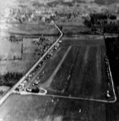
A 1930s aerial view looking south at Bernard Field.

The earliest aeronautical chart depiction which has been located of Bernard Field was on the June 1934 Portland Sectional Chart.

On 9/11/38 the Oregonian reported that Bernard Airport was "perhaps the busiest noncommercial airport in the United States -
Beaverton - where exists the added distinction that most of the planes are amateur-built."
George Yates designed & built his Bi-motor aircraft at Bernard Airport in 1940.
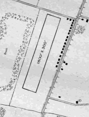
The 1945 AAF Airfield Directory (courtesy of Scott Murdock) described Bernard Field as a 53 acre property having a single 1,800' sod north-northeast/south-southwest runway.
A row of no less than 30 hangars was described along the east side, and the field was said to be owned by private interests but not in operation.
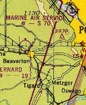
Bernard Field was depicted on the 1948 Portland Sectional Chart (courtesy of Chris Kennedy) as having a 1,900' unpaved runway.
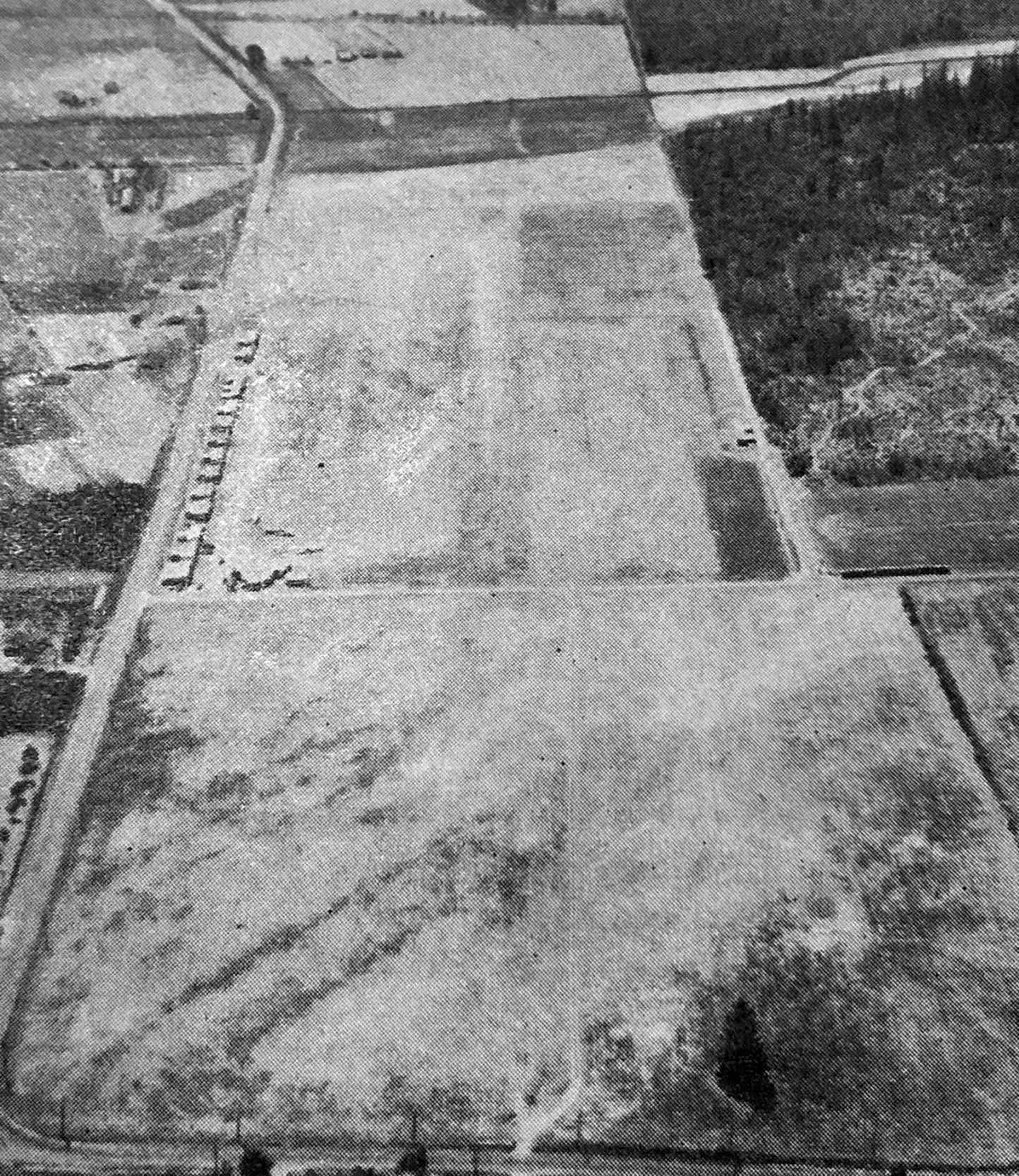
A circa 1940s aerial view looking south (courtesy of Ed Das) depicted Bernard Field as having a single northeast/southwest unpaved runway, with rows of T-hangars on the east side.

The 1949 OR Airport Directory (courtesy of Jonathan Westerling)
depicted Bernard Airport as having a single 1,850' sod & gravel northeast/southwest runway.
The manager was listed as Charles Bernard.

A 10/25/51 USGS aerial view depicted Bernard Field as having a single northeast/southwest unpaved runway,
with rows of T-hangars on the west & east sides, and a dozen light aircraft parked on the east side.

A 1955 street map (courtesy of Kevin Walsh) depicted “Bernard Field Airport” as having a single northeast/southwest runway.
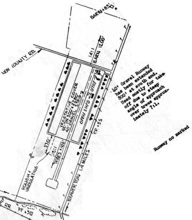
The 1960 OR Airport Directory (courtesy of Ron Dupas)
depicted Bernard Airport as having a single 2,280' gravel northeast/southwest runway.

An 8/1/60 USGS aerial view depicted Bernard Field as having a single northeast/southwest unpaved runway,
with rows of T-hangars on the west & east sides, and several light aircraft parked on the east side.

The 1961 USGS topo map depicted Bernard Airport as having a single northeast/southwest runway.

A 1966 aerial view looking north along Cedar Hills Boulevard at Beaverton Airport.
It appeared as if the runway had been paved at some point between 1948-66.
The field had a large number of individual T-hangars on the west & east sides of the field,
and a dozen light aircraft were also visible parked on the field.

Bernard Field was depicted on the 1968 Portland Sectional Chart (courtesy of John Voss) as having a 2,400' paved runway.
According to the City of Beaverton web site, Bernard Field was closed in 1969.
At that time it was Oregon's oldest operating airport.
The former airport was demolished to make room for the Beaverton Mall.

A circa 1960s/70s photo of what appears to have been the remains of a North American FJ-4 Fury behind the still-incomplete Beaverton Mall, the site of Bernard Field.
It is unknown what the aircraft had been doing there, as Bernard Field's runway would have been too short to operate a Fury.


As seen in the 2002 USGS aerial photo, the site Bernard Field is now occupied by the Cedar Hills Crossing shopping center,
with not a trace of the former airport appearing to remain.
Joe Bernard reported in 2013, “ The McMenamin's Restaurant on the Cedar Hills crossing site [is] dedicated to the airport.
There are many clear pictures of the people & the hangars that made the airport what it was.”

A 1/28/17 photo by Kevin Walsh looking southwest at the site of Bernard Field, occupied by a shopping center.
The site of Bernard Field is located southwest of the intersection of Cedar Hills Boulevard & Jenkins Road.
Thanks for Karl Gruber for pointing out this airfield.
See also: http://www.youtube.com/user/BernardsHistory
____________________________________________________
Tongue Point Naval Air Station, Astoria, OR
46.2, -123.765 (Northwest of Portland, OR)

The October 1942 Seattle Sectional Chart depicted the Tongue Point seaplane base as the "US Naval Air Station".
In 1919, Congress approved the construction of a submarine & destroyer base on Tongue Point, a peninsula jutting into the Columbia River.
In 1921, Clatsop County transferred ownership of 395 acres to the federal government & dredging began that same year.
Construction was completed in 1924, with a breakwater & four wooden finger piers extending into Cathlamet Bay.
However, with decreased military appropriation following World War I, the base was never used.
Groundbreaking for a Naval Air Station at Tongue Point began in 1939, to be used as a base for seaplane patrols of the coastline.
As there were many delays with Tongue Point, the Navy began to use 2 other nearby civil airports,
Moon Island Airport in Hoquiam, WA, and Clatsop County Airport in Warrenton.
The earliest depiction which has been located of NAS Tongue Point was on the October 1942 Seattle Sectional Chart.
It depicted the Tongue Point seaplane base as the "US Naval Air Station".
PBY Catalinas arrived at Tongue Point in 1943 and began coastal patrols.
But this proved difficult due to the logs & other floating debris on the Cathlamet Bay, which made takeoff & landing conditions hazardous.

A WW2-era aerial view looking east at Tongue Point NAS (National Archives photo).
From 1943-1944 the station's intended mission was temporarily sidetracked,
when its facilities were used instead to assist the Kaiser Company in a critical shipbuilding program.
This became the facility's most significant role during WW2,
as a pre-commissioning & commissioning site for escort aircraft carriers
(better known as "jeep flattops") built in the big Victory ship yards in the Portland-Vancouver area.
In 1944 the PBY Catalinas at Tongue Point were replaced by larger & more capable PBM Mariners.

"Tongue Point (Navy)", as depicted on the March 1945 Seattle Sectional Chart (courtesy of Chris Kennedy).
Anti-submarine patrols from Tongue Point were discontinued with the end of WW2 in 1945, and the station was placed in a caretaker status in 1946.
Following WW2, Tongue Point was converted to a moorage facility for the Ready Reserve fleet.
To accommodate this fleet, 8 new concrete piers were built out into Cathlamet Bay.
From 1946-1962, the Navy stored as many as 250 mothballed Liberty ships at the facility.


An amazing 1958 aerial view showing over 100 mothballed ships in storage at Tongue Point.

A 1958 aerial view looking east showing over 100 mothballed ships in storage at Tongue Point & nearby Mott Island.
By 1962, the Tongue Point Naval Air Station was transferred to the General Services Administration as excess property.
When the station was deactivated by the Navy it consisted of 842 acres of land & water areas & 320 structures.
The Coast Guard Group / Air Station Astoria was established in 1964 at Tongue Point Naval Station.
A crew of 22 officers & 104 enlisted men operated 2 single-engine HH-52A Seaguard helicopters from Tongue Point.
The helicopters staged from the Port of Astoria Airport during periods of inclement weather.
This was done until the Air Station was permanently moved to its present location at the Warrenton Airport in 1966.
In 1981, the federal government sold much of the land (including 2 of the 3 hangars) to the State of Oregon.
Part of the facilities are used as the Tongue Point Job Corps Center.

The 1984 USGS topo map depicted the seaplane hangars & piers at Tongue Point.

Undated photo looking west at the northern Tongue Point seaplane hangar, control tower, and seaplane ramp.

A 2014 aerial view showed the Tongue Point seaplane ramp, 3 hangars, and piers.
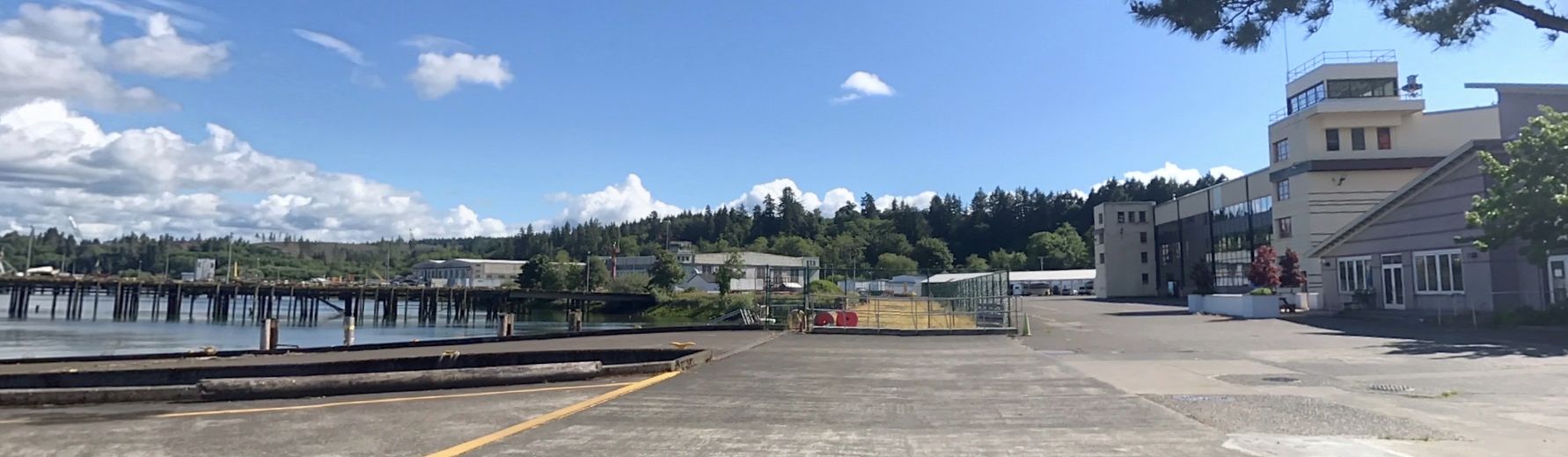
A June 2020 photo looking southwest at the Tongue Point seaplane ramp, hangars, and control tower.

An August 2022 aerial view looking north at the Tongue Point seaplane ramp, 3 hangars, and piers.
The historic USS High Point (PCH-1), the U.S. Navy's first hydrofoil, is seen at bottom-left, when it spent its last days at Tongue Point after being purchased by a private individual who intended to make her seaworthy once again.

A November 2022 photo looking northeast inside the southern Tongue Point seaplane hangar.

An August 2023 photo of the scrapping of the historic hydrofoil USS High Point (PCH-1) on the Tongue Point ramp, after severe corrosion was found below her waterline.
A 1997 Army Corps of Engineers report gave further details about Tongue Point.
____________________________________________________
Or if you prefer to contact me directly concerning a contribution (for a mailing address to send a check),
please contact me at: paulandterryfreeman@gmail.com
If you enjoy this web site, please support it with a financial contribution.
____________________________________________________
This site covers airfields in all 50 states.