Abandoned & Little-Known Airfields:
Oregon: Portland
© 2002, © 2026 by Paul Freeman. Revised 5/24/26.
This site covers airfields in all 50 states: Click here for the site's main menu.
____________________________________________________
Please consider a financial contribution to support the continued growth & operation of this site.
Oregon City Airpark (revised 5/24/26) - (Original) Portland Municipal Airport / Swan Island Airport / Swan Island Heliport (revised 12/23/23) - Skylife Airport (revised 6/29/19) - Silverton Airport (revised 12/31/22)
Troh's Airport / Division Street Airport (revised 12/31/22) - Troh's Nest / Troh's Memorial Air Park / Happy Valley Airport (revised 12/31/22) - Troh's Skyport (revised 12/31/22) - Wells Airport (revised 6/28/21)
____________________________________________________
45.455, -122.616 (South of Downtown Portland, OR)
Wells Airport, as depicted on the April 1947 Portland Sectional Chart.
This small general aviation airport on the south side of Portland was evidently established at some point between 1946-47,
as it was not yet depicted on the October 1946 Portland Sectional Chart.
The earliest depiction which has been located of Wells Airport was on the April 1947 Portland Sectional Chart.
It depicted Wells as having a mere 1,700' unpaved runway.

The 1947 OR Airport Directory (courtesy of Richard Loenetti) described Wells Airport as having a 1,700' soil & turf east/west runway.
The manager was listed as Zon Wells.

The only topo map depiction which has been located of Wells Airport was on the 1952 USGS topo map.
It depicted Wells Airport as having a short east/west runway, with 3 small buildings on the west side.
The only photo which has been located of Wells Airport was a 1952 aerial view.
It depicted Wells Airport as having a short east/west runway, with a light single-engine aircraft parked near 2 small buildings on the southwest side.
Bill Prendergast recalled, “I grew up in the Eastmoreland neighborhood, at 28th & Lambert Streets.
Amongst my parents' friends was Gene Waddle, a private pilot who flew a nice, radial-engined Cessna….either a 190 or a 195 taildragger.
When I was about 12 years old (1954), I was aviation crazy.
Beside building dozens of model planes & flying control line models, I LOVED to visit airports, especially small ones where you could ride your bike out & peer into the parked airplanes.
So I was not unfamiliar with the small airports in the East Portland area. But I had never known of the existence of Zon Wells Airport.
In 1954,when I found out that my parents' friend, Mr. Waddle had an airplane (!) I began a steady campaign of convincing them to wangle me a ride.
Finally that paid off & Gene Waddle, a very nice guy, spent some time on a Saturday taking me for an airplane ride.
My mom drove me to a very small airport not far from our home where Mr. Waddle had landed to meet us. I had never heard of that airport & never knew it’s name.
But I remember where it was… pretty close to my home. It was in a partly built up, suburban/rural (in those days!) area.
There’s no doubt in my mind that Zon Wells Airport is where we were.
After showing me his plane, Mr. Waddle strapped me in the right seat & took me for a nice ride around the Portland area (no TCAs in those days!).”
Wells Airport evidently closed at some point between 1954-60,
as a 1960 aerial photo showed the property covered by dense suburban houses.
Yet another of America's thousands of grassroots airports swallowed by the insatiable demand for housing.

A 2017 aerial photo showed no trace remaining of Wells Airport.
The site of Wells Airport is located at the intersection of Southeast Fieldcrest Street & Southeast Fieldcrest Drive.
Thanks to Richard Leonetti for pointing out this airfield.
____________________________________________________
45.54, -122.518 (East of Downtown Portland, OR)

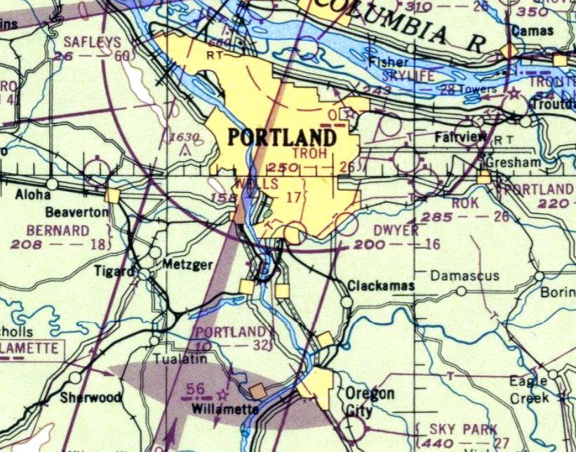
Skylife Airport, as depicted (along with a dizzying array of other Portland-area general aviation airports) on the April 1947 Portland Sectional Chart.
This small general aviation airport on the east side of Portland was evidently established at some point between 1946-47,
as it was not yet depicted on the October 1946 Portland Sectional Chart.
The earliest depiction which has been located of Skylife Airport was on the April 1947 Portland Sectional Chart.
It depicted Skylife as having a 2,800' unpaved runway.

Skylife Airport, as depicted (along with a dizzying array of other Portland-area general aviation airports) on the 1949 USGS topo map.
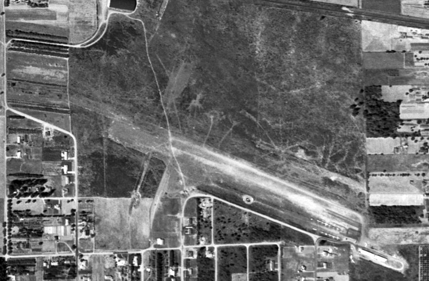
The only photo which has been located showing Skylife Airport was an October 1951 aerial view.
It depicted Skylife Airport as having a 2 unpaved runways, with some small buildings & over a dozen light aircraft parked on the southeast side.

The last aeronautical chart depiction which has been located of Skylife Airport was on the September 1954 Portland Sectional Chart.
It depicted Skylife as having a 2,400' unpaved runway.
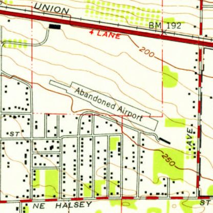
Skylife Airport was evidently closed in 1954, as it was labeled “Abandoned Airport” on the 1954 USGS topo map.
It was depicted as having a single northwest/southeast runway, with one small building on the southeast end.
According to “The Russell Neighborhood's Boundary & Housing Development”,
“The Russell neighborhood’s Skylife Airfield was sold after loosing it’s bid to become the Portland Airport in 1954 & developed into the Clifgate subdivision.
The 121-acre site previously occupied by the Skylife Airfield became the largest housing project on Portland’s Eastside in 1955.”
Skylife Airport was no longer depicted on the April 1955 Portland Sectional Chart.
A 1960 aerial view showed no trace remaining of Skylife Airport, with houses & a school covering the property.
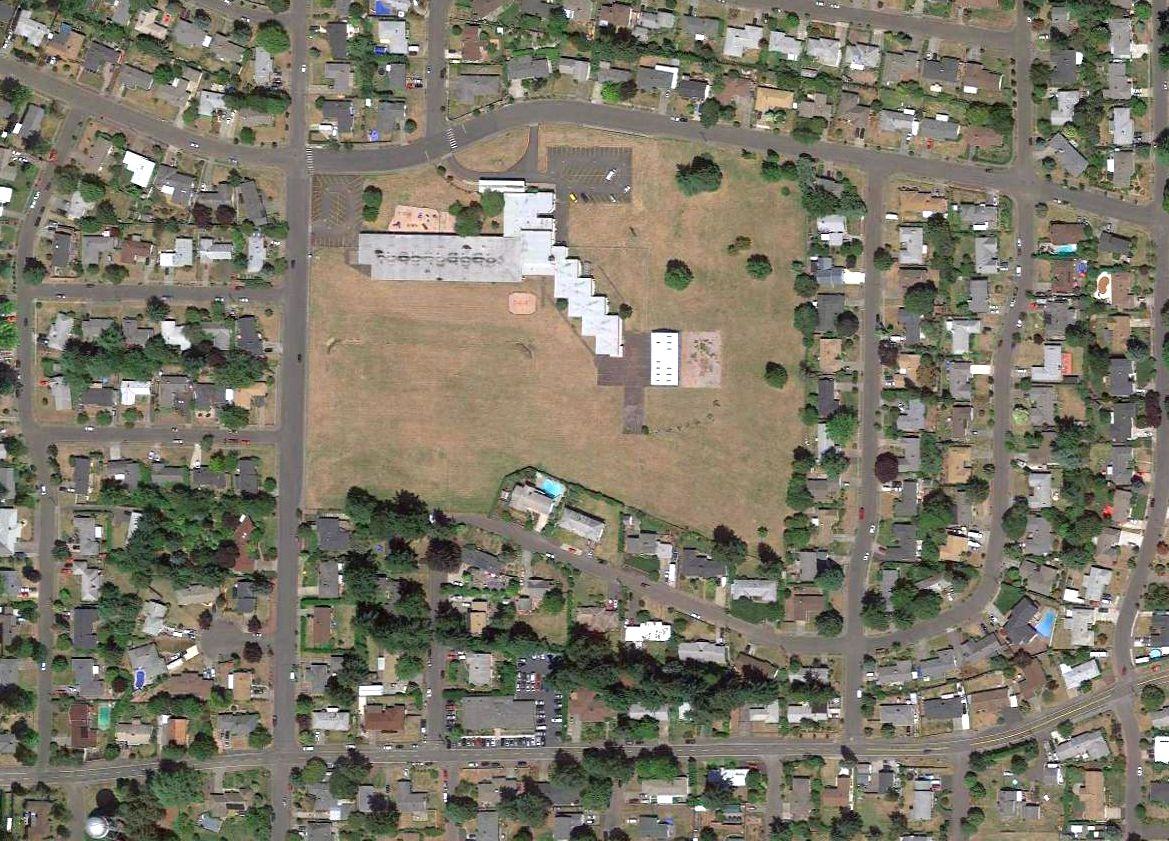
A 2016 aerial photo showed no trace remaining of Skylife Airport.
The site of Skylife Airport is located north of the intersection of Northeast Eugene Court & Northeast 142nd Avenue.
____________________________________________________
Oregon City Airpark (0S2), Oregon City, OR
45.277, -122.597 (South of Portland, OR)

Oregon City Airpark, as depicted on the October 1964 USAF Operational Navigation Chart (courtesy of Chris Kennedy).
This general aviation airport was apparently built at some point between 1963-64,
as it was not depicted on the October 1960 Portland Sectional Chart, a 1960 aerial photo, or the 1961 USGS topo map,
nor listed in the 1963 AOPA Airport Directory (according to Chris Kennedy).
The earliest depiction which has been located of Oregon City Airport
was on the October 1964 USAF Operational Navigation Chart (courtesy of Chris Kennedy).
The July 1969 Portland Sectional Chart (courtesy of Chris Kennedy)
depicted Oregon City as having a single 2,500' paved east/west runway.

The 1970 USGS topo map depicted Oregon City Airpark as a single unpaved east/west runway with a few small buildings on the southeast side.
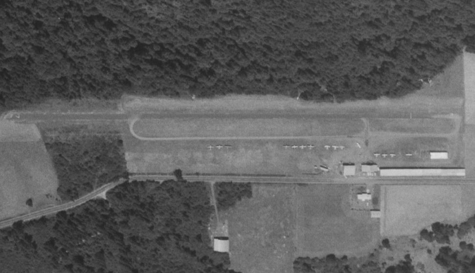
The earliest photo which has been located of Oregon City Airport was a 7/6/70 USGS aerial view.
It depicted Oregon City Airpark as having a single unpaved east/west runway with a few small buildings & a dozen light aircraft on the southeast side.
The 1976 AOPA Airport Directory (according to Chris Kennedy) described the Oregon City Airpark
as being operated by the Keystone Aircraft Company.
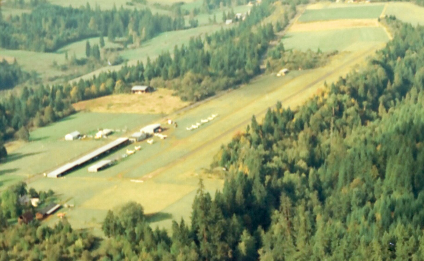
A September 1973 aerial view looking southwest by April Wicker (Civil Air Patrol Observer) & Frank Bueneman (Civil Air Patrol Pilot)
depicted Oregon City Airpark to have a single paved east/west runway, with several hangars & 11 light aircraft on the southeast side.

The January 1982 Seattle Sectional Chart (courtesy of Paul Columbus) depicted Oregon City Airpark as having a single 2,500' paved east/west runway.

The 1993 Flight Guide (courtesy of Chris Kennedy) depicted Oregon City Airpark as having a single 2,485' paved Runway 7/25 (which was described as "Ruf").
A parallel taxiway was located on the south side, and several hangars & small buildings were located south of the taxiway.
Ultralights were said to operate from the field.

A 1994 aerial view looking northwest showed Oregon City Airpark remained intact, but there were no aircraft visible on the field.

The last aeronautical chart depiction which has been located of the Oregon City Airpark was on the January 1994 Seattle Sectional Chart (courtesy of Ron Plante).
It depicted Oregon City as having a single 2,500' paved east/west runway.
The Oregon City Airpark was evidently closed (for reasons unknown) at some point between 1994-98,
as it was no longer depicted on the 1998 World Aeronautical Chart or the June 1999 Seattle Sectional Chart (courtesy of Ron Plante).
A 2000 aerial view showed that the end had come for this nice little airfield,
with houses having been built right up to the runway, which was evidently being reused as a street, South McDonalds Place

A 2004 aerial view looking southwest at Oregon City Airpark.

A 2015 aerial view looking northwest at the site of Oregon City Airpark, with the runway reused as a residential street.
____________________________________________________
Silverton Intermediate Field / Silverton American Legion Airport / Adams Airport / Silverton Airport,
Silverton, OR
45.015, -122.805 (Southwest of Portland, OR)

A 1928 photo of a group in front of “Webfoot” (biplane model undetermined) at Silverton Airport (courtesy of Lee Corbin).
Lee Corbin reported, “According to the Oregon State heritage site, Silverton [Airport] was constructed in 1917.”
According to Jonathan Westerling, “The Silverton Airport was an on-again off-again airport
which dates back to the 1920s & the San Francisco - Seattle Airway.”
The earliest depiction which has been located of the Silverton Airport was a 1928 photo of Charlie Reynolds, Earl Hartman, John Small, Bill McClary,
Jim Hollingsworth, Al Adams, Russell Boelster, and Brick Hoblet, in front of “Webfoot” (biplane model undetermined) (courtesy of Lee Corbin).
The Silverton Airport was not yet depicted in the 1930 Department of Commerce Airport Directory (according to David Brooks).

The earliest chart depiction which has been located of the Silverton Airport
was on the 1931 Department of Commerce Aeronautical Bulletin (courtesy of Jonathan Westerling).
It depicted Silverton as a commercial/municipal airport, Site 53 along the San Francisco - Seattle Airway.
It was apparently built as one of the Department of Commerce's network of Intermediate Fields,
which were constructed in the 1920s & 1930s for the emergency use of commercial aircraft flying routes between major cities.
The 1932 Department of Commerce Aeronautical Bulletin (courtesy of Jonathan Westerling)
described Silverton Airport as a Department of Comerce Intermediate Field, Site 53 along the San Francisco - Seattle Airway.
The field was said to be located ¾ of a mile northwest of the city, on the north side of the highway.
The property was said to be a 76 acre sod L-shaped field,
with 3 runways, the longest being a 2,350' northwest/southeast strip.
A hangar was said to be marked with “Silverton American Legion Airport” on its roof.
Silverton Airport was listed among active airfields in The Airport Directory Company's 1933 Airport Directory (according to Chris Kennedy).

The earliest aeronautical chart depiction which has been located of Silverton Airport was on the June 1934 Portland Sectional Chart.
Silverton Airport was listed among active airfields in The Airport Directory Company's 1938 Airport Directory (according to Chris Kennedy).

The 1940 USGS topo map depicted an airport symbol at the location of Silverton Airport, but did not label the airport.
However, Silverton Airport was no longer listed among active airfields
in The Airport Directory Company's 1941 Airport Directory (according to Chris Kennedy).,
and was not depicted on Portland Sectional Charts from 1941, 1943, or 1945 (according to Chris Kennedy).
According to Dave Watson (the Silverton Airport property owner in 2008),
he grew up across from the airport & said that it was used to train WW2 pilots.
However, according to Chris Kennedy, “There weren't any Army Air Forces contract schools in Oregon in WWII.
It is possible though that Silverton was part of the Department of Commerce CPT program.
However, this program did not typically use intermediate fields, so I would say it isn't too likely it was used.”
Silverton Airport was not listed among active airfields
in the Haire Publishing Company's 1945 Airport Directory (according to Chris Kennedy)
or the 1945 AAF Airfield Directory (courtesy of Scott Murdock).
The airport was evidently renamed “Adams Airport” at some point between 1932-48,
as that is how it was labeled on the October 1948 Portland Sectional Chart (courtesy of Chris Kennedy).
It depicted Adams as having a 3,300' unpaved runway.

The 1949 OR Airport Directory (courtesy of Jonathan Westerling)
described Adams as a commercial airport managed by A.L. Adams.
It was said to have a single north/south 3,340' turf runway.
Adams Airport was depicted on the 1950 USGS topo map.

The earliest photo which has been located of Silverton Airport was an 8/1/53 USGS aerial photo.
It depicted the field as having a north/south grass runway, with 5 small hangars along the southwest side.
One of the hangars was painted with a large “X”, possibly indicating the airport was closed by this point?
Silverton / Adams Airport apparently ceased operation at some point between 1950-54,
as it was as it was not depicted at all on the 1954 Portland Sectional Chart (according to Chris Kennedy),
the 1956 USGS topo map, or the 1965 Portland Sectional Chart (according to Chris Kennedy).
Silverton Airport may have reopened at some point between 1965-67,
as it was once again listed among active airfields in the 1967 AOPA Airport Directory (according to Chris Kennedy).
It was described as having a single 3,340' turf Runway 16/34.
It was described as a "Private airstrip. Use at own risk."
Silverton Airport apparently closed again at some point between 1967-70,
as it was not depicted at all on the 1970 Portland Sectional Chart (according to Jonathan Westerling)
or the January 1975 Seattle Sectional Chart (according to Chris Kennedy).
Silverton Airport evidently reopened as a private airfield at some point between 1975-76,
as that is how it was listed in the 1976, 1977, and 1978 AOPA Airport Directories (according to Jonathan Westerling).
Will Werner recalled, “I landed several times at Silverton Airport in the 1970s & 1980s.
Instructors considered it a place to practice soft field landings & takeoffs.”
Silverton Airport was still listed in the 1980 AOPA Airport Directory (according to Chris Kennedy).
It was described as having a single 2,500' turf Runway 16/34.
It was described as a "Private airstrip. Use at own risk."
The Silverton Airport may have been closed again at some point between 1980-82,
as it was not depicted at all on the 1982 or 1985 USGS topo maps,
nor listed among active airfields in the 1982 AOPA Airport Directory (according to Chris Kennedy).
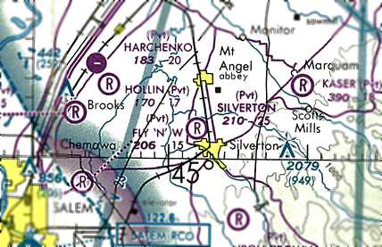
The Silverton Airport was evidently reopened once again at some point between 1982-89,
as it was depicted as a private airfield on the 1989 Sectional Chart (courtesy of Jonathan Westerling).
It depicted Silverton as having a 2,500' unpaved runway.

A circa early-1990s photo by John Guilmette a former hangar at Silverton Airport.
John reported, “Some non-aviation businesses were already using some of the hangars.
I believe the one curved-roof hangar was one of the originals.”

A circa early-1990s photo by John Guilmette of hangars & a single-engine Cessna at Silverton Airport.
John reported, “At this time the 'Airport' was just barely still in use.”

A circa early-1990s photo by John Guilmette looking along the former runway of Silverton Airport.
John reported, “Notice some genius built a house right on the south end of the runway (don't land 'long' when landing to the south).”

A circa early-1990s photo by John Guilmette of a historical sign at Silverton Airport.

The Silverton Airport was evidently closed (again) at some point between 1989-94,
as a 1994 USGS aerial view looking northwest showed the runway had reverted to agriculture.
However 3 (or possibly more) hangars remained standing.
The Silverton Airport was no longer listed among active airfields in the 1995 AOPA Airport Directory (according to Jonathan Westerling).
John Guilmette recalled, “I went back a few years later [after the early 1990s]
and all the planes were gone & the grass & weeds had grown up on & thru the runway.
I had briefly looked into buying the whole airport.”
Jonathan Westerling reported in 2008, “Sometime after 2000, the current owner installed a narrow runway that can't be more than 20' wide.
I spoke with Dave Watson who currently owns the property as well as operating BC Plumbing in town.
He said previous owners reestablished the runway there in 2000 after an earlier owner had let the airport lapse.”
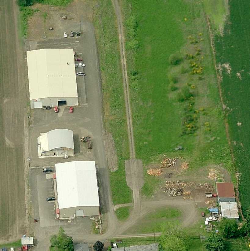
A circa 2006 aerial view looking north at the south end of Silverton's runway,
showing the narrow gravel runway with a slightly-wider asphalt turnaround pad at the end.
What looks to be one arch-roof hangar is on the left, with possibly 2 other small hangars at the bottom-right.
It is not known if the 2 larger buildings on the left were ever used as hangars.
Jonathan Westerling reported in 2008, “The turnaround areas are paved for about 150' on each end. Most of the runway is gravel.
According to a lady from one of the businesses on the field, it has been almost 2 years since a plane landed there,
but there were several takeoffs each week for several years before that.
Mr. Watson applied for permit to reestablish an airport there (it is currently within the county's jurisdiction),
but was turned down 'because I didn't have a pilots license.'
He has since encouraged the city of Silverton to include the property in its expanded boundary since the city is in favor of the airport -
which makes sense given the fact that small airports bring a unique source of revenue to communities.
Perhaps this historic airport will live again?”

A 2017 aerial view looking northwest shows the historic Silverton Airport remains intact, including the grass runway with asphalt turn-around pads at each end, and 3 hangars on the southwest side.
Silverton Airport is located northeast of the intersection of Airport Road & Aviation Way, appropriately enough.
Thanks to Jonathan Westerling for pointing out this airfield.
____________________________________________________
(Original) Portland Municipal Airport / Swan Island Airport / Swan Island Heliport, Portland, OR
45.56, -122.71 (Southwest of Portland International Airport, OR)

A 9/16/27 photo by Ralph Vincent (courtesy of Lee Corbin) of spectators gathered around Charles Lindbergh’s plane, the Spirit of St. Louis, at Swan Island Airport.
In 1925, like many growing urban areas, Portland insisted on having an airport.
According to Wikipedia, “Oakley Kelly, the commanding officer at Pearson Airfield in Vancouver WA was one of the first to seriously propose using Swan Island as an airfield.
In 1926, the Port of Portland, assisted by the United States Postal Service organized a committee to look for a location for a new airport in Portland.
The group chose Swan Island which was a peninsula along the Willamette River.
Objections over the airport started almost immediately, as postal workers who were using Pearson Airfield claimed Swan Island might flood.
A plan was drawn up to raise the elevation of Swan Island to keep floodwater out.
W. L. Thompson spearheaded the commission & was the project's Chief Engineer.
In a proposal to the Port of Portland, the west channel of the Willamette River next to Swan Island would have to be widened, and a dike built to keep high water out.
The project extended its timeline in May 1926, forcing the USPS to keep using Pearson Airfield in Vancouver to deliver mail to the city.
Most of the accommodations for the USPS at Swan Island Municipal Airport opened in September 1926, but commercial services were still being readied.
During its construction, the Port of Portland requested that the Swan Island Municipal Airport be the future site of the Pacific Coast Air Derby, which was approved.”
The Port of Portland purchased 253 acres, and construction of Swan Island Airport began in 1926.
According to Wikipedia, “Swan Island Municipal Airport officially dedicated in September 1927 by Charles Lindbergh who flew the Spirit of St. Louis onto the airstrip.
Although the field was not officially complete, most of the facilities like hangars & landing strips were finished.”
The earliest depiction which has been located of Swan Island Airport was a 9/16/27 photo by Ralph Vincent (courtesy of Lee Corbin)
of spectators gathered around Charles Lindbergh’s plane, the Spirit of St. Louis.
The photo was taken shortly before Lindbergh's departure for San Francisco.
According to Wikipedia, “Upon its completion, Swan Island Airport cost $557,073.
The official opener for the Swan Island Municipal Airport came on September 27 during the Pacific Coast Air Derby where 6 army planes performed for 10,000 paid spectators.”

A 1927-36 aerial view looking southeast at Swan Island Airport's terminal, hangars, and runway (courtesy of Lee Corbin).

A 1927-36 photo (courtesy of Lee Corbin) of a Buhl Bull-Pup & a Ford Tri-Motor of Pacific Air Transport in front of the Swan Island Airport Terminal Building.

An October 1928 plan for “Port of Portland Airport, Swan Island” (courtesy of Lee Corbin).
It depicted 5 runways laid along a narrow peninsula, with the longest being a 2,175' hard-surface northwest/southeast strip.
No buildings were yet depicted, but instead space for 5 “admin buildings” was depicted to the east of the runways.
According to Wikipedia, “A gravel runway was installed in 1928, replacing the old dirt one.
In 1929, Varney Air Lines started passenger services between Portland & Boise ID & later that year from Portland to Salt Lake City UT & Portland to Pasco WA.”


A 1929 aerial view looking southeast showed Swan Island Airport's 4 runways.

A 1930 photo showing a large number of biplanes & spectators at Swan Island Airport.


A 1932 aerial view looking east showed Swan Island Airport to have 4 runways, with several hangars along the north side.
According to Trish Nicola, flight instructor Al Greenwood trained Chinese-Americans as pilots at Swan Island in the early 1930s.

The earliest depiction which has been located of Portland Airport was on the June 1934 Portland Sectional Chart.

A 1935 photo of a Fokker Trimotor in front of Swan Island's terminal.

A 3/12/35 aerial view looking northwest at Swan Island Airport.

An undated postcard view looking southeast, captioned “The Port of Portland Airport, Formerly Swan Island Airport”.
According to Wikipedia, “The Port of Portland & the Portland City Council held meetings in 1935 to investigate a possible renovation of the Swan Island Municipal Airport.
They determined that it would not be cost effective to rebuild the airport to accommodate larger aircraft.
By 1936, citizens were petitioning the city council to fund a larger airport at a higher elevation.
I. E. Oakes, the Works Progress Administration director for Portland announced in 1937
that he would look to secure US$627,781 in funds from the federal government to build a new runway to accommodate large airlines.
However, the federal government condemned the site & offered up funds to build a new airport.
After the Portland–Columbia Super Airport was constructed, the Swan Island Municipal Airport still operated, although in a diminished capacity.
Flying students were banned from using the airport in their training programs due to the low altitude.
The military removed their facilities from the airport & most commercial liners had moved their services to the new airport.”

An aerial view looking south at the “Portland Municipal Airport”,
from The Airport Directory Company's 1937 Airport Directory (courtesy of Bob Rambo).
The directory described the airport as consisting of a rectangular sod field, one which were 4 runways.
A hangar was said to be marked with “Portland” on the roof.

A 1938 aerial view of Swan Island Airport.

A circa 1940 photo of the landside of Swan Island Airport's terminal.

A 1940 photo of George Yates making a final check on his Bi-motor prior to a test flight from Swan Island Airfield.
This aircraft was just one of the many planes designed and built by Yates at Bernard Airport.

“Port of Portland Airport” was depicted on the 1940 USGS topo map as having 4 paved runways.

The original Portland Airport on Swan Island was still depicted as an active airfield
on the November 1941 Portland Sectional Chart (courtesy of Chris Kennedy).
Swan Island Airport was evidently closed at some point between 1941-42,
as it was no longer depicted at all on the July 1942 Portland Sectional Chart.
However, an adjacent seaplane facility was still shown.
According to Wikipedia, “During World War II, Swan Island was the location of the Oregon Shipbuilding Corporation where 455 vessels were produced for the United States Military.”

A 1945 aerial view looking south at the shipyards which covered Swan Island by that time,
with not a trace left of the former airport.
According to Wikipedia, “After the war the obsolete shipyards & the old airstrip were converted into a drydock for the Port of Portland.”

Swan Island evidently was reused for seaplane operations for some period,
as an April 1948 advertisement (courtesy of Kevin Walsh) for “Marine Air Service now at Swan Island”
touted flight training & charter service in Waco F-2, Seabee, Cub, and Taylorcrafts.
Swan Island's last period of aviation use was as a heliport,
as an article in the Fall 2003 issue of Rotor magazine reported that in 1962 Columbia Helicopters moved their operations from Troutdale Airport to Swan Island.
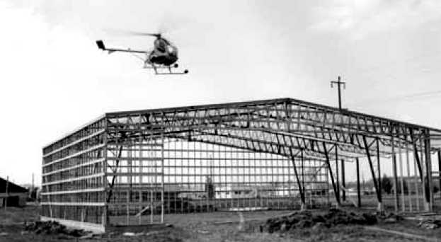
A 5/2/62 photo of Wes Lematta flying a Columbia Helicopters Hughes 269 over the frame of his new Swan Island headquarters.

A 7/18/62 aerial view of the grand opening of Columbia Helicopters' Swan Island facility,
showing a Kaman HH-43 Huskie, a Bell 47, and a Hughes 269 on the ramp in front of their hangar.
Was the Kaman operated by Columbia, or a visiting military aircraft?

An 8/8/63 photo of Wes Lematta providing flight instruction in a Columbia Helicopters Hughes 269 at Swan Island.

An undated aerial view of 2 helicopters on the helipad in front of the Columbia Helicopters hangar at Swan Island heliport
from the 1964 OR Airport Directory (courtesy of Jonathan Westerling).
The operator was listed as Columbia Helicopters.
In 1969, Columbia Helicopters purchased 3 tandem-rotor Boeing-Vertol 107-II's from Pan Am.

The last aeronautical chart depiction which has been located of Swan Island
was on the June 1969 Portland Sectional Chart (courtesy of Chris Kennedy),
which depicted Swan Island as a heliport.
In 1976 Columbia Helicopters vacated Swan Island, moving their operations to Aurora, OR,
according to an article in the Fall 2003 issue of Rotor magazine.
This presumably was the end of the aviation use of Swan Island.
A 1990 aerial photo showed that the former Columbia Helicopters facility had been replaced by newer commercial buildings,
erasing the last trace of aviation facilities on Swan Island.
Keith Wood reported in 2005 that “Much of the eastern half of the airport site
belongs to Freightliner Corporate headquarters & related facilities.
The headquarters itself has a 'natural' colored roof, but is served by the large parking lot in the southeast corner of the island.
The largest of the grey-roofed buildings is a training center for DaimlerChrysler.”

A 2018 aerial view looking north showed the site of Swan Island Airport is now occupied by various commercial facilities, with not a trace of the former airport appearing to remain.
The site of Swan Island Airport is located at the intersection of North Dolphin Street & North Lagoon Avenue.
____________________________________________________
Troh's Airport / Division Street Airport, Gresham, OR
45.51, -122.47 (Southeast of Portland, OR)
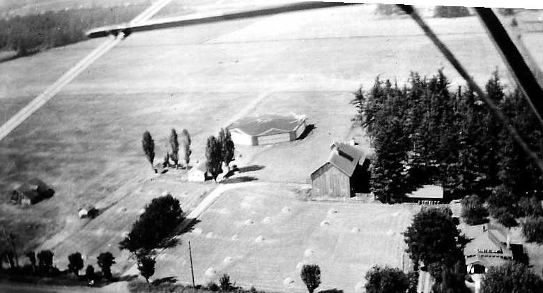
A 1935 aerial view by Hank Troh from his CK Bird biplane of Troh's Airport, showing the hangar & grass airfield (courtesy of Jonathan Westerling).
Jonathan Westerling reported, “Henry (Hank) Troh was a pioneer in Portland’s early days of civil aviation.
According to the 2009 Oregon Aviation Historical Society Newsletter (Volume 19, Issue 2),
from the mid-1930s until he died, Hank built & operated 3 separate airfields where he made his living providing pilots with a full spectrum of aviation services.
His first airport was at the intersection of Division Street & Rockwood Road in Gresham which bordered Portland to the east.”
Jonathan continued, “Henry Troh’s daughter, Lorraine Troh Gabel, has written a 350 page book detailing her father's aviation contributions entitled 'Time Flies'.
According to her book, in 1935 while still working as a steam shovel operator,
Troh leased land located in Gresham to establish a small landing facility for his CK Bird biplane.
The airfield was built on an old dairy farm – the cow barn was repurposed for plane storage & the milking room became the mechanic's garage.
The runway was a single east/west turf strip running the length of the property.
One unique feature of the airport was a hexagonal hangar which had the windsock prominently located on the center top of its roof.
Troh grew the airport business offering rides in his CK Bird airplane with the slogan 'Time Flies, Why Don’t You?'.”
The earliest depiction which has been located of Troh's Airport was a 1935 aerial view by Hank Troh from his CK Bird biplane,
showing the hexagonal hangar & grass airfield.
Jonathan Westerling reported, “By 1937 it [Troh's Airport] was a full-time operation for him & his first wife Ruth.
For unknown reasons, the airport was apparently never listed in any official directories,
though it was well used, particularly as interest in aviation grew leading up to World War II.
The East/West grass runway was listed as 1,400' long in a 3/22/42 article in the Oregonian newspaper.
The same article noted that a Stinson Tri-Motor & 22 other airplanes had been recently moved to Troh’s airport when Swan Island Airport closed.”
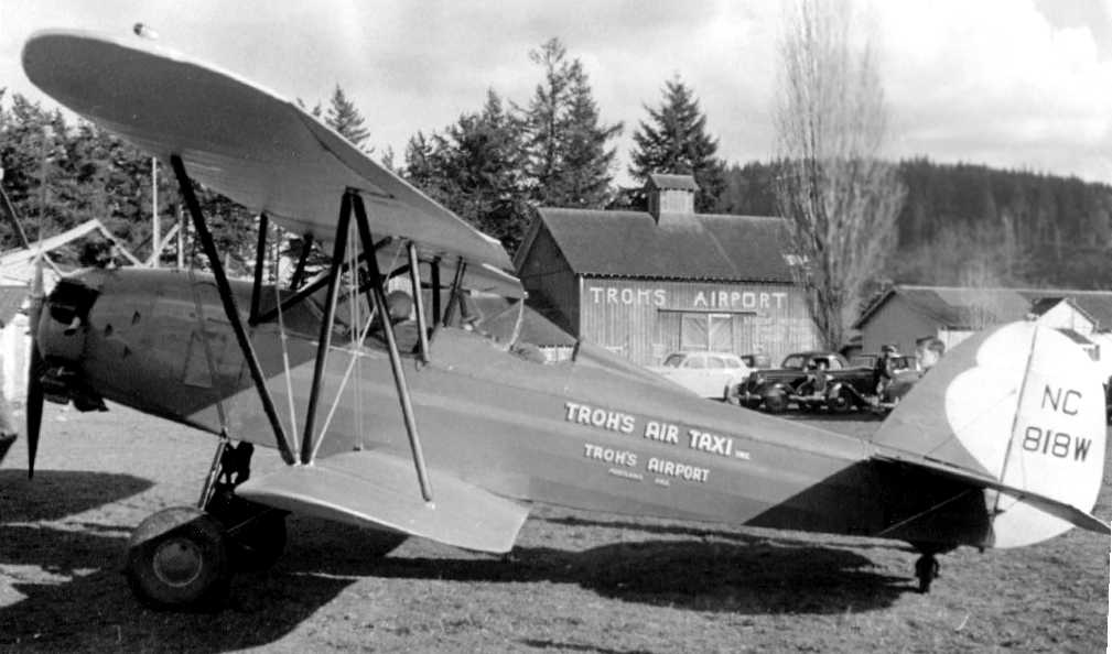
An undated (circa late 1930s?) photo of Troh’s CK Bird biplane in front of the Troh's Airport barn / hangar (courtesy of Jonathan Westerling).
Trohs' Airport was not yet depicted on the November 1941 Portland Sectional Chart.
Jonathan Westerling reported, “According to Lorraine Troh Gabel, as World War II began to escalate, civil aviation was no longer permitted west of the Cascade mountains.
Taking this in stride, Henry Troh formed a Civil Air Patrol group based at his field.
Numbering 60, they were responsible for maintaining security of the airport & supporting any government flights in & out of the airfield.
Because of the CAP watch, Troh’s Airport was one of the only airfields in the area licensed to store airplanes without dismantling.
Storage fees provided a limited income to Troh’s Airport but not enough to make ends meet.
Troh left Portland in April of 1942 for a job as a flight instructor at Tex Rankin’s Flight Academy in Tulare, CA.
In his absence, his mother & father looked after his airfield though no planes were allowed to land or take off.
At the Rankin Academy, Troh trained hundreds of Cadets until he received his Honorable Discharge in the fall of 1944.”
Trohs' Airport was still not depicted on the November 1944 Portland Sectional Chart.

The earliest aeronautical chart depiction which has been located of Trohs' Airport was on the April 1945 Portland Sectional Chart.
It depicted Trohs as a commercial/municipal airport.
Jonathan continued, “After the War, Troh returned to Portland & ran Troh’s Airport for a short time,
extending a new north/south runway to 2,200' by leasing an adjacent parcel.
But the airport wasn’t big enough for him & he started building a larger airport he called 'Skyport' about a mile east.”

An early 1946 aerial view of Troh’s Airport, just before it changed to the Division Street Airport (courtesy of Jonathan Westerling).
Jonathan remarked, “More than 12 planes can be seen along the flight line.”
Jonathan Westerling reported, “According to Lorraine Troh Gabel, in May of 1946 his lease on the property was lost
and transferred to a competing flight training operation, much to his chagrin.
Troh was forced to immediately move his belongings to the not-yet-completed Skyport.”
Jonathan continued, “After Troh left, the airport was reopened as the Division Street Airport.”

The 1948 Portland Sectional Chart (courtesy of Chris Kennedy) shows an amazing array of airports in the Portland area,
including both Troh’s original airfield (“Division” Street) & his new “Trohs” Skyport airport to the west.
The 1949 USGS topo map (courtesy of Jonathan Westerling) shows an amazing array of airports in the Portland area,
including both Troh’s original airfield (“Division Street”) & his new “Trohs Skyport” airport to the west.
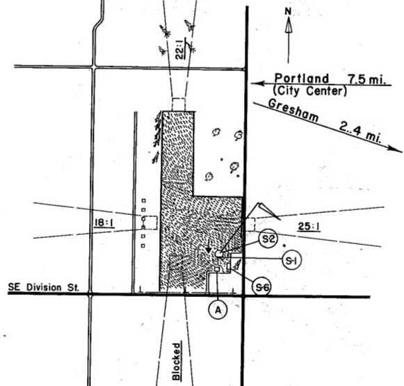
The 1949 Oregon Airport Directory (courtesy of Jonathan Westerling) described Division Street Airport as having 2 runways,
measuring 2,200' north/south & 1,300' east/west.
The 1951 Airman's Guide (according to Jonathan Westerling) described Division Street Airport as having a 2,200' runway.

The last depiction which has been located of Division Street Airport was on the March 1951 Portland Sectional Chart.
It depicted Division Street Airport as having a mere 1,200' unpaved runway.
Division Street Airport evidently closed at some point in 1951,
as it was no longer depicted on the October 1951 Portland Sectional Chart.
Jonathan Westerling reported, “According to Lorraine Troh Gabel, the Division Street Airport ceased operations by 1954.
A photo taken that year shows the airport buildings largely dismantled.”

An 8/21/11 aerial photo showed no trace remaining of Troh's Airport.
The site of Troh’s Airport is located northeast of the intersection of Division Street & Southeast 182nd Avenue.
____________________________________________________
Troh's Skyport, Centennial, OR
45.51, -122.5 (Southeast of Portland, OR)

A late 1945 aerial view showing the grading underway for the construction of Skyport (courtesy of Lorraine Troh Gabel, via Jonathan Westerling).
Jonathan Westerling reported, “The Portland Skyport was brainchild of Henry Troh, a well known Portland area pilot.
After World War II, Henry Troh had completed his duties as a flight instructor with Tex Rankin’s Flight Academy in Tulare, CA
and returned to his native Portland to revisit his airport business.
He found a partner in Harold Wagner, a long time pilot & owner of the Mixermobile manufacturing company.
The two collaborated to lease acreage for a new, modern civil aviation airport. They began construction of the airfield in 1945.”
The earliest depiction which has been located of Skyport was a late 1945 aerial view
showing the grading underway for the construction of Skyport (courtesy of Lorraine Troh Gabel, via Jonathan Westerling).
Troh's Skyport was not yet depicted on the April 1946 Portland Sectional Chart.

A 6/30/46 photo of the airport office & some of the crowd gathered for opening day at Skyport (courtesy of Lorraine Troh Gabel, via Jonathan Westerling).
Jonathan Westerling reported, “Opening day was 6/30/46 & celebrated with an afternoon airshow.
The Portland Journal estimated the crowd at 7,000.
At the time the airport was opened, only the North/South runway (14/32) was completed.
The cross runway (3/21) was finished 2 years later in 1948 (according to Lorraine Troh Gabel in her biography of her dad, 'Time Flies').
When completed, the airport had 2 runways in the shape of an X.”
A 7/2/46 Bend Bulletin article (courtesy of Jonathan Westerling) said Skyport also had a large 160’ x 100’ hangar
built entirely from steel & aluminum (there was a shortage of wood after the war),
and referred to the field as the largest privately-built airport in the state.
A 6/27/46 Gresham Outlook article (courtesy of Jonathan Westerling) had additional details about the hangar complex:
“A novel construction has been used for the hangar. On each of the 4 corners, a half circle has been constructed.
In these will be housed offices for various aircraft distributors, a lounge, and the main airport office.”

The earliest aeronautical chart depiction which has been located of Troh's Skyport was on the October 1946 Portland Sectional Chart.
It depicted 'Troh” as having a 2,600' unpaved runway.

A 1947 aerial view looking north at Skyport with both runways completed (courtesy of Lorraine Troh Gabel, via Jonathan Westerling).
The 1949 USGS topo map (courtesy of Jonathan Westerling) shows an amazing array of airports in the Portland area, including Trohs Skyport.

The 1949 Oregon Airport Directory (courtesy of Jonathan Westerling) described Troh's Skyport as having 2 runways
(measuring 2,640' northwest/southeast & 2,350' northwest/southeast), with a few small buildings on the south & southeast sides.
Sometime after 1950 (according to Lorraine Troh Gabel) the apron & southern half of the north/south runway were paved by Harold.
The 1951 Airman’s Guide (courtesy of Jonathan Westerling) described Skyport as boasting full mechanical capabilities (“major repairs”) & floodlights at night.
Jonathan Westerling reported, “During the post WW-II boom in aviation, the airfield enjoyed considerable success.
Three rows of T-hangars were constructed, and a full service café was opened
inside one of the half-circles in the large hangar on field – the Skyroom Café, open weekends.
The airfield had many employees, and even a club for women pilots called 'Troh’s Sky Queens'.
Hundreds of students were trained at the field & many aircraft; Bellancas Pipers, and Swifts were sold by Troh & his associates.
The first paraplegic to be granted a pilots license, Russell Herlford, did so under Henry Troh’s instruction at the Skyport (according to Lorraine Troh Gabel).”

A 10/25/51 USGS aerial photo depicted depicted Trohs Skyport as having 2 runways, of which the southern half of the northwest/southeast runway was paved.
Twenty light aircraft were visible parked near the hangar on the south side, and 2 rows of T-hangars were on the southeast side.
What were the 4 large circular markings on the southwest portion of the runway?

An undated cartoon entitled “Fright Line at Troh’s” hopefully dramatizing a student’s first landing attempt (courtesy of Lorraine Troh Gabel, via Jonathan Westerling).
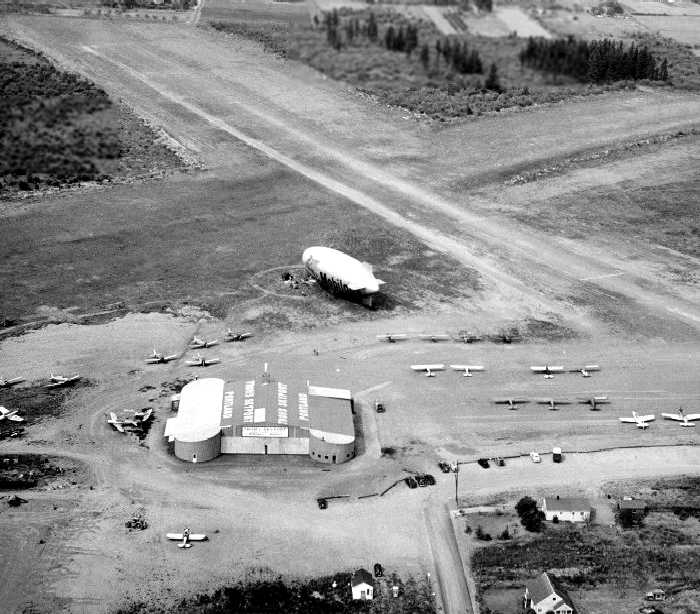
An undated aerial view looking north at Skyport (courtesy of Lorraine Troh Gabel, via Jonathan Westerling),
showing a Mobilgas blimp, dozens of light aircraft, and the hangar with its distinctive rounded corners.
According to Jonathan Westerling, “The Goodyear & Mobilgas blimps were based at Troh’s when special events brought them to Portland.”
Jonathan Westerling reported, “Many newspaper clippings make mention of Henry Troh during these years
ferrying debutantes, stranded vacationers, and even barrels of fingerling trout around the state.
Banner advertising was done from the field, as were blimp operations for special events.”

An undated photo from an April 1952 article showing one of Harold Wagner’s 3 experimental Twin Cubs in front of Skyport's hangar (courtesy of Jonathan Westerling).
Jonathan Westerling reported, “Harold Wagner, Troh’s business partner, experimented with an airplane design at Skyport
that was featured on the front cover of the June 1961 issue of Popular Mechanics magazine.”
The article in the magazine written by Leverett Richards, reported how “Wagner, now co-owner of the Mixerrnobile Company
and partner in Henry Troh's Skyport in Portland, recently built himself a ‘Piper Bomber’ from two Cubs."
His idea was create an “inexpensive twin-engine airplane” by mating 2 Piper Cubs together at the wing.
Harold's “Twin Cubs” were also featured in the March, 1952 issue of the AOPA magazine.
The article reported, “Concerned over the high cost of even the smallest twin-engined planes, [Wagner] decided to make one of his own.
He bought 2 Cub trainers, each with more than 1,500 hours on it.
According to Wagner, the whole thing cost him less than $2,500 & took 2 mechanics 5 days to complete.
They simply hacked up the 2 planes & mated them. The most unusual feature is the overlapping propellers.
The blades are only 2 inches apart, but - although the Wagner Twin has flown more than 25 hours - the overlapping props have caused no trouble.”
An article by Leo Kohn in the November 1973 issue of Aero Magazine had additional information about the flight testing at Skyport:
"On 12/6/51 after Wagner ran taxi tests for about 5 minutes at Troh's Skyport to feel out the ship,
he took it to the end of the runway, swung the tails around, and opened up the engines.
To the consternation of many, the Wagner-Twin was flying.
It leapt into the air, and one prop did not blank out the other as the 'experts' had feared.
The airplane handled quite normally with plenty of reserve power.
Because of the dual power units, each could run at a lower setting & the airplane still fly better than in its single engine mode.
The name 'Wagner-Twin was registered & patents were applied for.
The federal government was unyielding & while getting approval to manufacture & sell commercially is one thing
and all kinds of difficulty and paperwork was to be expected, just putting up with the red tape to keep the research airplanes flying was hardly worth the effort."
Eventually the 3 planes produced for the experiments were dismantled.
Jonathan Westerling reported, “On 2/27/55, the airport was in the newspapers up & down the west coast
when a gale blew through the valley & took out 2 of the 3 lines of steel T-hangars at Skyport, destroying all of the planes inside.”
Henry Troh was quoted in the Spokane Daily Chronicle: ”Ironically several planes outside the hangars escaped damage.
That was because they were tied down when the wind warning came yesterday.”
Troh said “The planes inside would have been tied down too, except that we never dreamed the hangars would go.”
Photos in the Portland Journal show the concrete piers pulled completely out of the ground.
Jonathan Westerling reported, “In 1957 after proposing a new combination airport/community park to deaf ears at the Portland City Council,
the tax burden of the property made maintaining Skyport a loosing proposition.”
Aviation Editor for the Oregonian, Leverett Richards, wrote about the Skyport just months before its closing:
"It is just a question of time until the pressure of population, rising property values & faster rising property taxes
will force the sale of such properties as Troh's for higher value use.”
Hank & Harold penned an editorial titled “How Will General Aviation Support Its Own Airports?”:
"We are the owners of an airport in a small town adjoining a metropolitan area.
We have just received our tax bill which runs close to $18,000.
This represents a $10,000 additional tax for this year over last, and there [was a] 100% increase the year before.”

The last aeronautical chart depiction to be located of Troh's Skyport
was on the April 1959 Portland Sectional Chart (courtesy of Paul Columbus)
It depicted Trohs as having a 2,600' unpaved runway.

A 1959 photo of the last plane to depart Skyport,
with the new houses which would cover the property already being constructed in the foreground (courtesy of Lorraine Troh Gabel, via Jonathan Westerling).
Jonathan Westerling reported, “Sure enough, the municipal taxes along with the construction of a new retirement community
forced Troh’s Skyport to close in June of 1959.”
The Skyport was no longer listed in the 1960 OR Airport Directory (courtesy of Ron Dupas)
nor depicted on the July 1965 Portland Sectional Chart (courtesy of Ron Kunse).

An 8/21/11 aerial photo showed no trace remaining of Troh's Skyport.
The entrance of Troh’s Skyport was located at the intersection of Division Street & Southeast 156nd Avenue.
____________________________________________________
Troh's Nest / Troh's Memorial Air Park / Happy Valley Airport (S15, OL03), Happy Valley, OR
45.45, -122.5 (Southeast of Portland, OR)

An undated aerial view from a 1961 article (courtesy of Jonathan Westerling) showing Troh's Airfield (“1”),
a 3-acre property bought by the Boy Scouts to block expansion of the airfield (“2”), and the remainder of Troh's property (“3”).
Jonathan Westerling reported, “Troh’s Nest was the 3rd & last of Henry Troh’s 3 Portland area airports.
He bought the land in 1957 when it became clear that city taxes & development were going to force the closure of his larger 'Skyport' airport
located in the rapidly developing area of east Portland.
This new airfield was to be somewhat of a retirement location for Henry, farther away from the growth and excitement of the city.
However 'Troh’s Nest' ended up being more of a project than either of his 2 previous airfields.
The airport was located on top of a hill (called 'Scouter’s Mountian') in rural Clackamas County.
After buying the land, Henry graded a preliminary short north/south airstrip on top of the hill which amounted to only about 1,200 usable feet.
Henry Troh & his wife Ethyl Piper (the aircraft manufacturer’s daughter) built a home & hangar adjacent to the airfield & moved there in 1958.
Their plan was to create a small fly-in community with houses for pilots adjacent to the runway.”
According to Lorraine Troh Gabel (in her biography of her dad “Time Flies”), when Henry’s “Skyport” Airport finally closed in 1958,
he focused on extending the short runway at Troh’s Nest.
He purchased the adjacent 47 acre tract to the south for this purpose but quickly realized he had a major problem.
Unknown to him, shortly after he purchased the initial parcel for his retirement airport,
his neighbor (a Boy Scout Adult Training Center) purchased a 3 acre square of land precisely at the south end of his runway
for the purpose of preventing him from extending it.
After being approached by Henry’s attorney, the Scout Council offered to sell the land they had purchased for $1,000 the year before to him for $10,000!
Troh was furious & refused to pay the outrageous sum.
Both of Portland’s local papers reported on the dispute with each one taking a different side on the matter.
The Troh's Nest Airfield was not yet depicted on the April 1959 Portland Sectional Chart (courtesy of Paul Columbus)
nor listed in the 1960 OR Airport Directory (courtesy of Ron Dupas).
The earliest depiction which has been located of Troh's Nest
was an undated aerial view from a 1961 article (courtesy of Jonathan Westerling) showing Troh's Airfield,
a 3-acre property bought by the Boy Scouts to block expansion of the airfield, and the remainder of Troh's property.

The 1961 USGS topo map depicted 2 runways at Happy Valley, labeled simply as “Airstrip”.

An undated aerial view from the 1964 OR Airport Directory (courtesy of Jonathan Westerling)
showing the completed 1st runway & construction of the 2nd runway at Troh’s Nest.
The 1964 Oregon Airport Directory (according to Jonathan Westerling) described Troh's Nest as having a 1,200' runway.
Jonathan Westerling reported, “Eventually Troh decided to fill in a valley on his property for a new, longer runway
which would sidestep the Scout Council blockade even though this took away the parcels on which he was going to build the additional homes for pilots.
The 2nd turf runway was finished around 1964. It was designated 14/32 and was 1,900' long according to the 1967 Airports USA Directory.”
The Troh's Nest Airfield was not depicted at all on the July 1965 Portland Sectional Chart (courtesy of Ron Kunse).

The earliest aeronautical chart depiction which has been located of Troh's Nest Airfield was on the February 1966 Portland Sectional Chart.
It depicted “Trohs” as a public-use airport with a mere 1,900' unpaved runway.

A 1967 aerial photo looking west at Troh’s Nest airfield with the 2nd longer runway completed (courtesy of Lorraine Troh Gabel via Jonathan Westerling).
Henry Troh’s house is in the foreground, and dozens of light planes were on the field.
Jonathan Westerling reported, “Henry Troh used it to run a successful charter business from the airport until his untimely passing from a brain tumor in 1968.”

The 1970 Portland Sectional Chart (courtesy of Jonathan Westerling) depicted “Trohs Nest” as a public-use airport with a 1,900' unpaved runway.

A 7/8/70 USGS aerial view depicted Trohs Nest as having 2 runways & 14 aircraft were visible parked outside.
Jonathan Westerling reported, “After Troh’s death, his wife & daughter negotiated a land trade with the Scout Council which removed the 3-acre blockade parcel
and allowed a 3rd runway (16/34) to be built to 2,300' feet according to the 1976 AOPA Airports USA.
Apparently, the original 1200’ runway and second runway 14/32 were not used after the longer runway was completed.”
Jonathan continued, “The airport was re-classified as public in 1977 (according to the 1977 Airports USA) and renamed the 'Troh Memorial Airpark'.
It received airport ID 'S15' from the state board of Aeronautics.
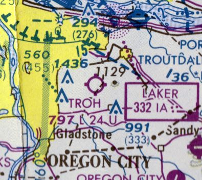
The February 1981 CF-16 World Aeronautical Chart (courtesy of Dallam Oliver-Lee) depicted “Troh” as a public-use airport with a 2,400' unpaved runway.
The runway was paved sometime between 1981-83 & renamed again as 'Happy Valley' according to the 1983 AOPA Airports USA.
The final dimensions of the airstrip were 2,300' x 25'.”

The 1984 USGS topo map depicted a northeast/southwest runway at Happy Valley, labeled simply as “Airstrip”,
along with the remains of a former northwest/southeast runway.

The last photo which has been located showing Happy Valley Airport while operational
was an undated photo from the 1989 OR Airport Directory (courtesy of Jonathan Westerling).
It showed the field to have a northwest/southeast runway, with 7 light planes parked around a few small buildings on the northeast side.
Troh’s Nest / Troh Memorial / Happy Valley was not listed in the 1995 or subsequent AOPA Airports USA directories (according to Jonathan Westerling).
Aerial photos indicate that a house was built between 2002-2006 at the south end of the runway which used the airstrip as its driveway.
Large “X”s were painted on either end of the runway.

A circa 2008 aerial view looking west at the former Troh house & hangar at the north end of the Happy Valley Airport site.

A circa 2008 aerial view looking north at the bizarre juxtaposition of a large house built immediately at the south end of the Happy Valley runway,
which continues to be listed with the FAA as an active airfield even though it obviously would not be safe for landings.
Jonathan Westerling reported, “Strangely, Happy Valley Airport was still depicted as an active airport on the 2010 Portland Sectional,
however given the runway obstructions, it is unlikely that it is usable as an airport.”
As of 2012, Happy Valley Airport was no longer depicted on Sectional Charts,
but inexplicably continued to be listed in the FAA Airport/Facility Directory data as an active private airfield (designator OL03).
It was described as having a 2,264' asphalt Runway 16/34,
and to have 3 aircraft based on the field (2 single-engine, and 1 helicopter), and to conduct an average of 33 takeoffs/landings per month.

An 11/30/14 photo looking south at the house that stands right at the end of the Troh's Memorial runway.
The photographer noted, “Not the sort of thing you want to see at the end of the runway!”

An 11/30/14 photo looking north along the Troh's Memorial runway.

A 2015 aerial view looking southwest at the former Troh house, hangar, and runway at Happy Valley.
The site of Happy Valley Airport is located east of the intersection of Southeast Vrandenburg Road & Southeast Airport Road, appropriately enough.
____________________________________________________
Or if you prefer to contact me directly concerning a contribution (for a mailing address to send a check),
please contact me at: paulandterryfreeman@gmail.com
If you enjoy this web site, please support it with a financial contribution.
____________________________________________________
This site covers airfields in all 50 states.