Abandoned & Little-Known Airfields:
Pennsylvania: Bucks County
© 2002, © 2025 by Paul Freeman. Revised 5/21/25.
This site covers airfields in all 50 states: Click here for the site's main menu.
____________________________________________________
Please consider a financial contribution to support the continued growth & operation of this site.
Buehl Field (Bensalem location) (revised 6/29/19) - Buehl Field (Woodbourne location) (revised 7/5/21) - Keystone / Fleetwings / Kaiser Field / Kaiser NAS / 3M Airport (revised 12/7/24)
Keystone / Fleetwings Factory & Seaplane Base (revised 12/7/24) - Morrisville Airport (revised 5/21/25)
Skyhaven Air Center (revised 6/18/19) - Silver Star Airport / Old Star Airport (revised 12/7/24)
____________________________________________________
Skyhaven Air Center, Morrisville, PA
40.19, -74.77 (Northeast of Philadelphia, PA)
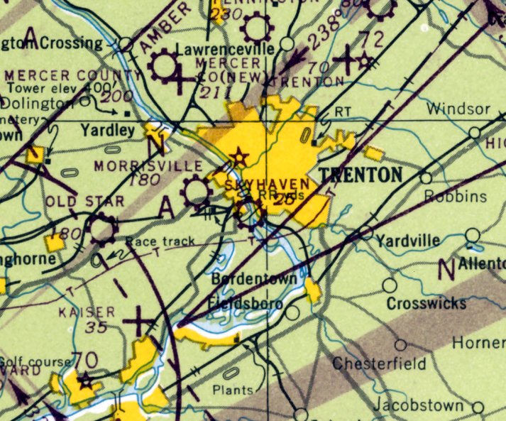
Skyhaven Air Center, as depicted on the July 1946 NY Sectional Chart.
Photo of the airport is not available.
This general aviation airport was evidently established in 1945,
as it was yet not listed among active airfields in the 1945 AAF Airfield Directory (courtesy of Scott Murdock)
nor depicted on the June 1945 NY Sectional Chart.
Diane Siesel Orr recalled, “My father, William Siesel, operated an airport on Pennsylvania Avenue, Morrisville, in 1945-47.
He sold Cessnas & Ercoupes. Together with several other men (Bucks County Scientific Society), he bought a P-51 Mustang. It was housed at the airport.
It was from this airport that my Mother & I flew to Los Angeles in a Republic SeaBee in the fall of 1946.
A man had flown into the airport in his SeaBee & my Dad brought him home for dinner. Next thing I knew my Mom & I were off to LA. Quite a trip.
The earliest aeronautical chart depiction which has been located of Skyhaven Air Center was on the July 1946 NY Sectional Chart.
It depicted Skyhaven as a commercial/municipal airport.
The only photo which has been located of Skyhaven Air Center was a 1947 aerial view.
It depicted the field as having 2 grass runways, with a few small hangars & 7 single-engine aircraft on the northeast side.
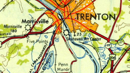
Skyhaven Air Center, as depicted on the 1949 USGS topo map.
The July 1949 NY Sectional Chart (courtesy of Ron Plante) depicted Skyhaven as having a mere 1,800' unpaved runway.
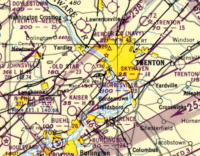
The last aeronautical chart depiction which has been located of Skyhaven Air Center
was on the January 1950 NY Sectional Chart (courtesy of Mike Keefe).
It depicted Skyhaven as having a mere 1,800' unpaved runway.
Skyhaven Air Center was evidently closed at some point between 1950-53,
as a 1953 aerial photo showed railroad lines had been built through the center of the field,
but one hangar remained on the northeast side of the property.
Skyhaven Air Center was no longer depicted on the January 1955 NY Sectional Chart.
Diane Siesel Orr recalled, “Much was destroyed when the rail lines for US Steel went through the property in the 1950s.”
A 1979 aerial photo showed no significant change at the site.
A 1995 aerial photo showed that the portion of the Skyhaven Air Center site to the west of the railroad tracks had been flooded.
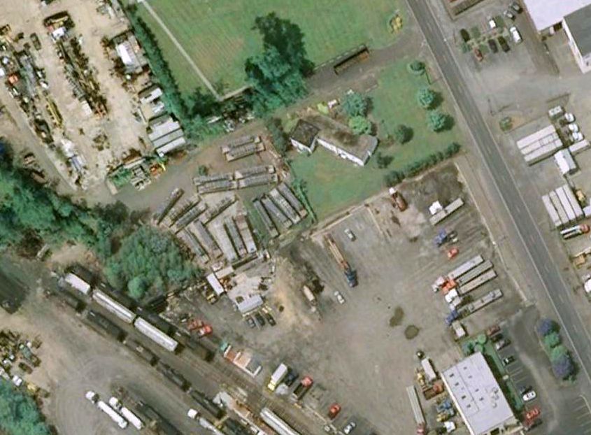
A 2004 aerial view showed a former hangar remained standing at the site of Skyhaven Air Center.
The last hangar from Skyhaven Air Center was removed at some point between 2004-2010, as shown in a 2010 aerial view.
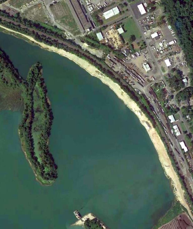
A 2013 aerial view showed the majority of the site of Skyhaven Air Center is under water.
The site of Skyhaven Air Center is located southwest of the intersection of South Pennsylvania Avenue & 5th Street.
Thanks to Diane Siesel Orr for pointing out this airfield.
____________________________________________________
Morrisville Airport, Morrisville, PA
40.2, -74.815 (Northeast of Philadelphia, PA)
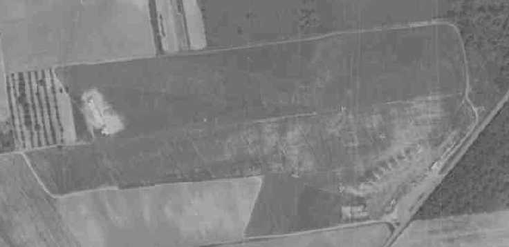
A 1947 aerial view of Morrisville Airport depicted the field as consisting of a single east/west grass runway,
with a single hangar on the southeast side, around which were parked a dozen light aircraft.
This general aviation airport was evidently established at some point between 1945-49,
as it was yet not listed among active airfields in the 1945 AAF Airfield Directory (courtesy of Scott Murdock).
Diane Siesel Orr recalled, “Morrisville Airport was owned by Frank Pingatore prior to Hortmann, [he] dealt with Piper Cubs.”
Verna Hortman (Bob Hortman's wife) recalled, “Norm & Bob Hortman (brothers) operated Morrisville Airport starting in 1949.
At that time the name of the operation was Aero Dusting Corporation.
They gave flight instructions, maintenance of aircraft, rebuilding & recovering aircraft
and crop dusting for King Farms & many other farms in the area.
I took care of all the office work during the Aero Dusting Corporation years.
Bob left Aero Dusting & went on to crop dust for several different operators throughout the country.”
The earliest photo of Morrisville Airport which has been located was a 1947 aerial view.
It depicted the field as consisting of a single east/west grass runway,
with a single hangar on the southeast side, around which were parked a dozen light aircraft.
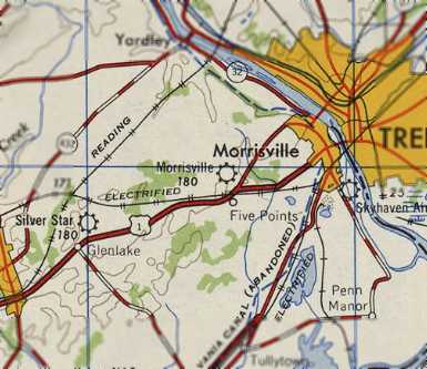
Morrisville Airport, as depicted on the 1947 USGS topo map.
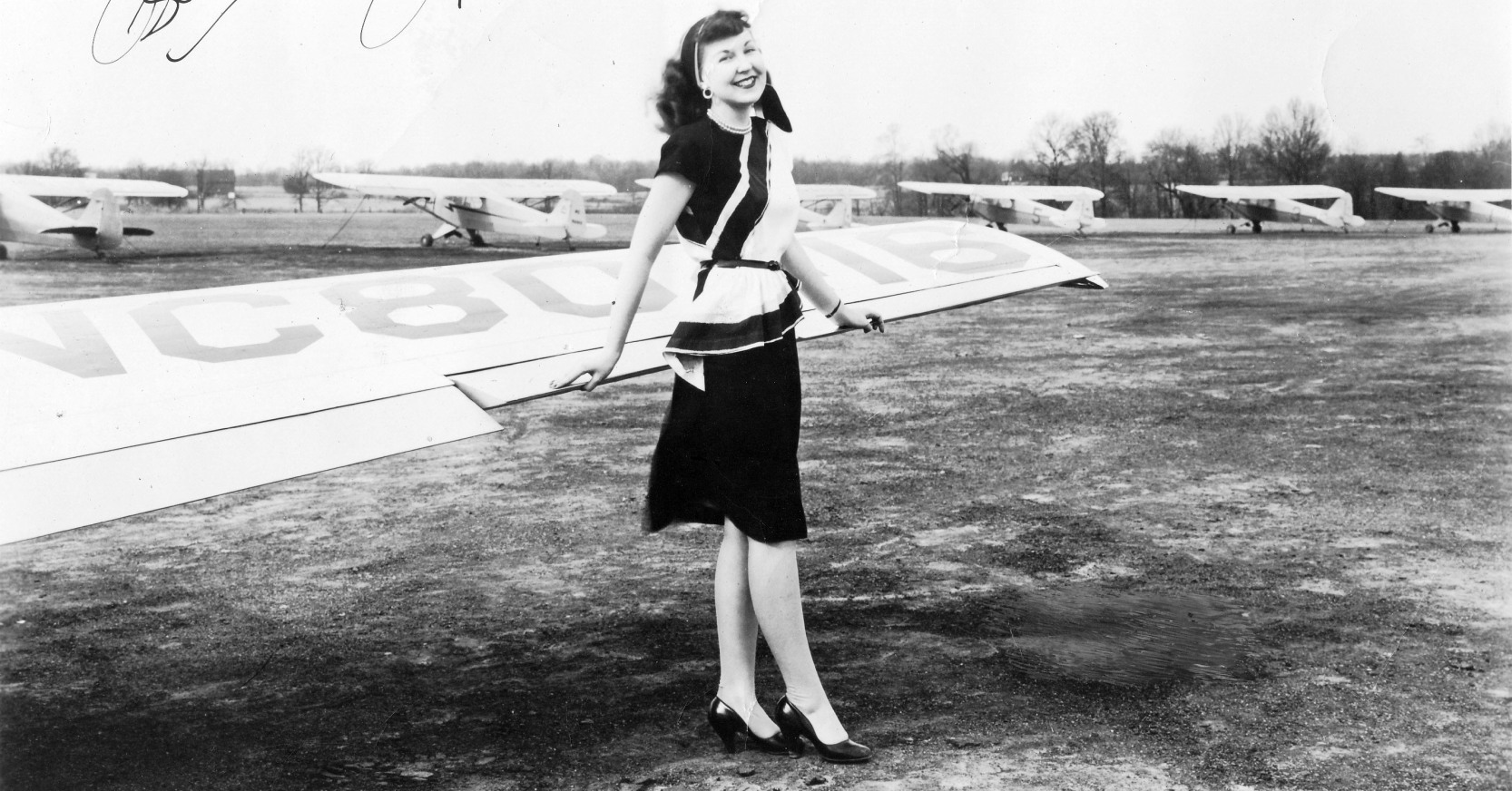
A photo apparently taken in 1947 at Morrisville Airport (courtesy of Jeanne Plate), which was signed, “May you always have blue skies, Rusty Austin. Morrisville Airport '47.”
Jeanne Plate reported, “I found the photo in my mother's photo album from her teenage years. She lived near Morrisville in the 1940s.
I can find nothing about Rusty Austin, either as a pilot or an actress, but from the quote that was included about Blue Skies, I'm guessing [she was a] pilot.
I'm wondering if Ms. Austin was there for some kind of promotional event for the airport.
My mother would have been about 16 at the time, and I'm guessing that a female pilot would have appeared to be glamorous to her.”
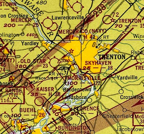
The earliest aeronautical chart depiction which has been located of Morrisville Airport
was on the July 1949 NY Sectional Chart (courtesy of Ron Plante).
It depicted Morrisville as having a 2,300' unpaved runway.
A 1953 aerial photo of Morrisville Airport depicted 13 light aircraft on the field.
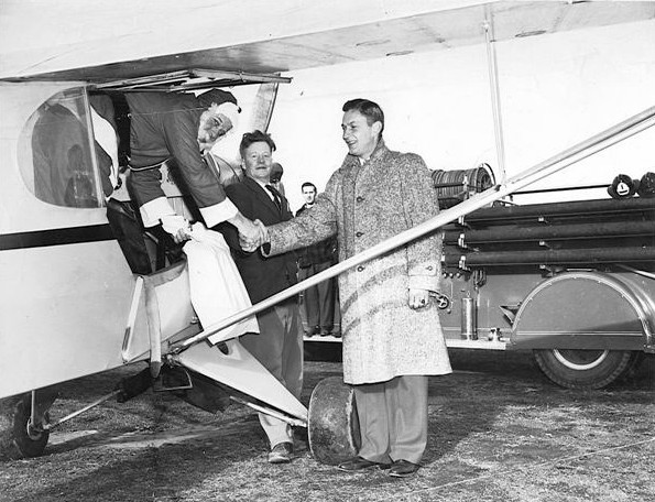
A circa early 1950s photo of Santa arriving at Morrisville Airport in a Piper Cub (courtesy of Robert Hedden).
Robert Hedden recalled, “The Falls Township Fire Company held an annual Christmas Party at a restaurant near the airport.
Santa, would do a fly over & wave to the kids, then he would be picked up by the fire engine & be taken to the party to distribute gifts.
Santa is Fire Fighter Jules Mazaros, Fire Chief Charles 'Reds' Steiner, Fire Fighter Hugh McHugh standing on the Truck, and Fire Fighter Cy Bachman.”
According to Nathan Sturman, Hortman Aviation was operated at Morrisville by Captain Norm Hortman & his wife Yvette.
"Norm was a very senior TWA Captain,
his French wife Yvette & he were well known to Philadelphia-area fliers,
especially the latter's legendary caution in supervising pilots & students/customers.
Hortman Aviation was famous in the 1950s for its line of yellow Cubs parked by Route 1."
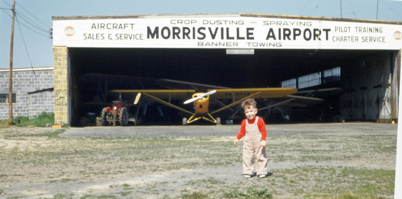
A 1956 photo by Joe Lyons II of Joe Lyons III in front of the Morrisville Airport hangar,
with a biplane, a Piper Cub, and several other aircraft inside the hangar.
A 1957 aerial photo of Morrisville Airport depicted 10 light aircraft on the field.
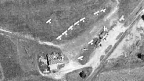
A 1958 aerial photo of Morrisville Airport depicted a dozen light aircraft on the field,
as well as the hangar with the checkerboard-painted roof.
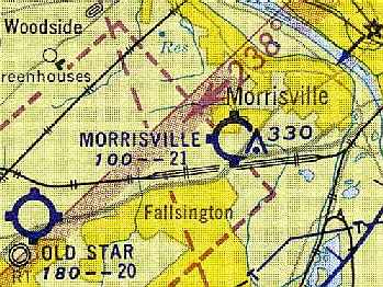
The 1959 Philadelphia Local Aeronautical Chart (courtesy of Chris Kennedy)
depicted Morrisville as having a 2,100' unpaved runway.
George Johnson recalled of Morrisville Airport, “Norm & Yvette Hortman hired me in 1961 for my 1st instructor job.
Three years & many new friends later, I was lucky enough to get hired by UAL.”
The 1962 AOPA Airport Directory (based on a latest report from 1960) described Morrisville as having a single 2,100' turf Runway 9/27.
The field was said to offer fuel, major repairs, and charter. The operator was listed as the Aero Dusting Corp.
A 1963 aerial photo of Morrisville Airport depicted a total of 12 light aircraft on the field.
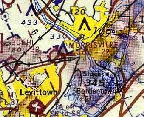
The 1967 NY Sectional Chart (courtesy of Mike Keefe) depicted Morrisville Airport as having a 2,200' unpaved runway.
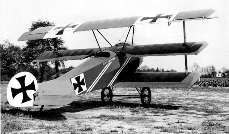
A November 1967 photo by George Baczkowski of a Fokker DR1 triplane replica at Morrisville.
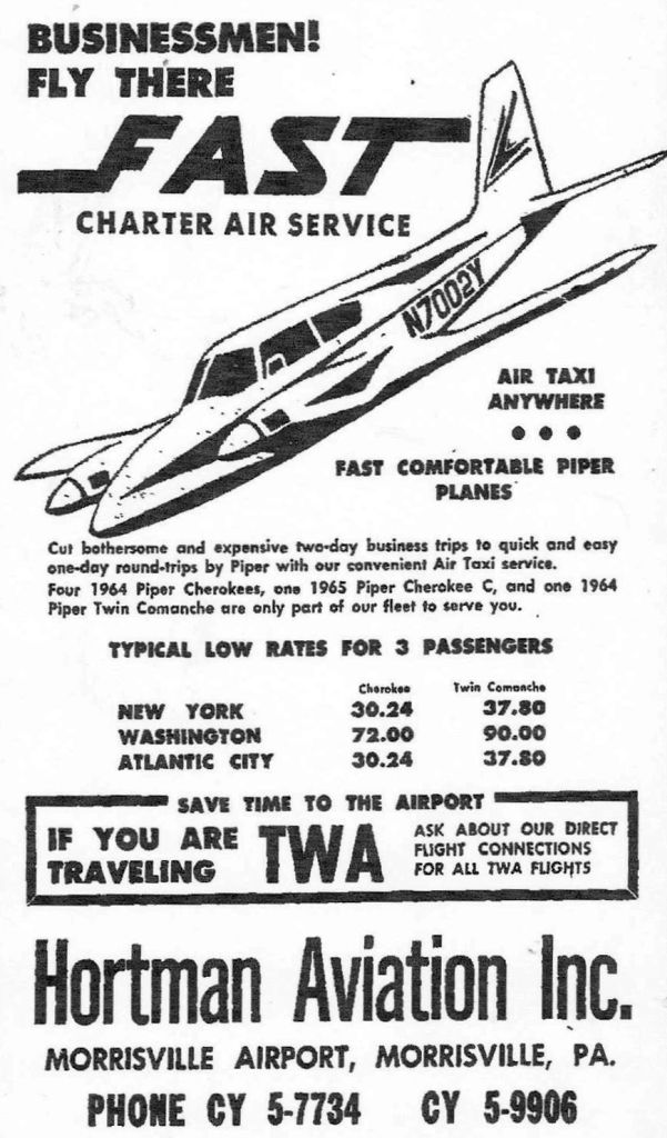
A circa 1960s advertisement for Hortman Aviation at Morrisville Airport (courtesy of Robert Hedden).
The last photo which has been located showing aircraft at Morrisville Airport was a 1970 aerial view,
which showed only 3 single-engine aircraft on the field.
According to Nathan Sturman, Morrisville Airport was closed (for reasons unknown) at some point in 1970.
When Morrisville Airport closed, Hortman Aviation moved to nearby 3M Airport.
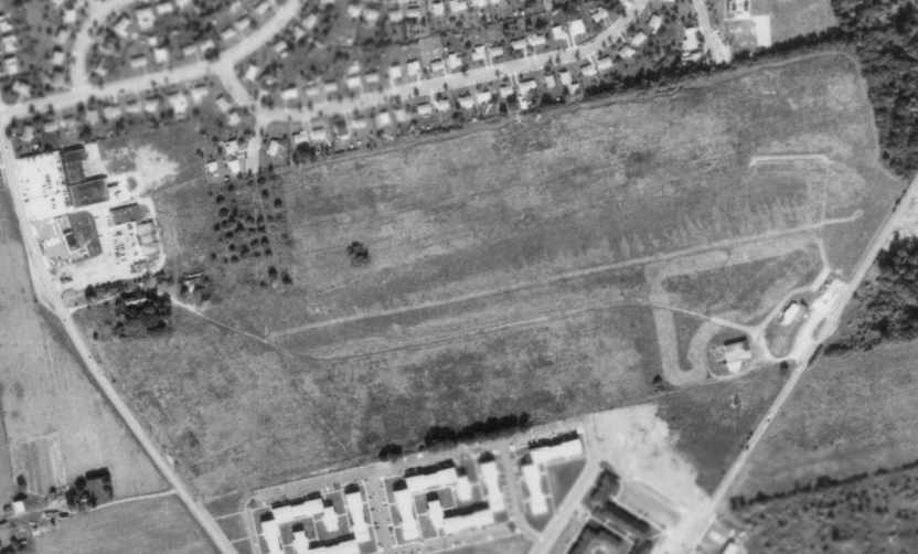
An 11/11/71 aerial view appeared to depict Morrisville Airport after it had been abandoned,
but the field was otherwise still intact, with a single east/west grass runway,
and some small buildings on the southeast corner of the property.
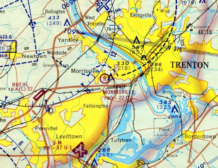
The last aeronautical chart depiction which has been located of Morrisville Airport was on the June 1972 NY Sectional Chart (courtesy of Carl Buick),
even though Morrisville Airport had reportedly been closed for 2 years by that point.
Morrisville Airport was depicted as a private airfield having a 2,200' unpaved runway.
Morrisville Airport was no longer depicted on the January 1973 NY Sectional Chart (courtesy of Ron Plante).
Paul Campbell recalled, “Morrisville Airport may have been abandoned by the mid-1970s but you would occasionally see a airplane fly in or out.”
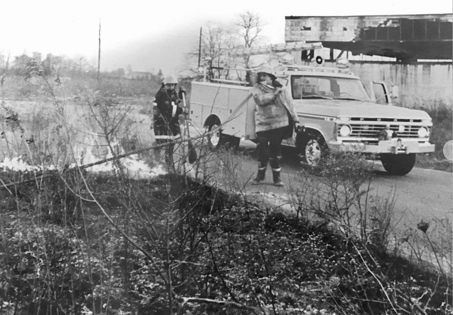
A circa 1976-77 photo of Falls Township Assistant Fire Chief Sherwood Taylor & Robert Hedden operating at a brush fire at Morrisville Airport (courtesy of Robert Hedden).
Robert Hedden recalled, “The airfield was a site of numerous brush fires.”
Paul Campbell recalled, “Morrisville Airport didn't get developed until the mid-1980s.”
A 1984 aerial view showed that a residential neighborhood had covered the site of Morrisville Airport ,
and no trace appeared to remain of the former airport.
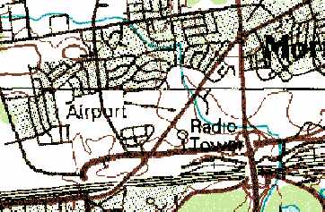
A single runway at Morrisville Airport was still depicted on the 1986 USGS topo map, labeled simply as "Airport",
even though a residential neighborhood had covered the airport site for a few years by that point.
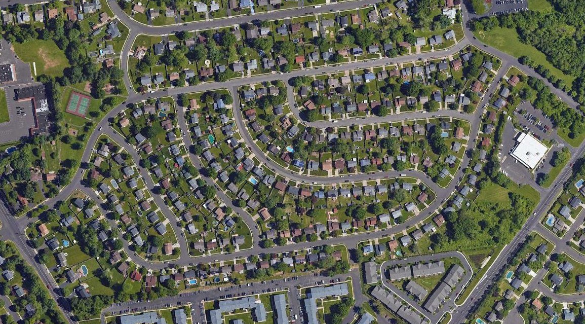
A 2019 aerial view did not depict any trace of Morrisville Airport.
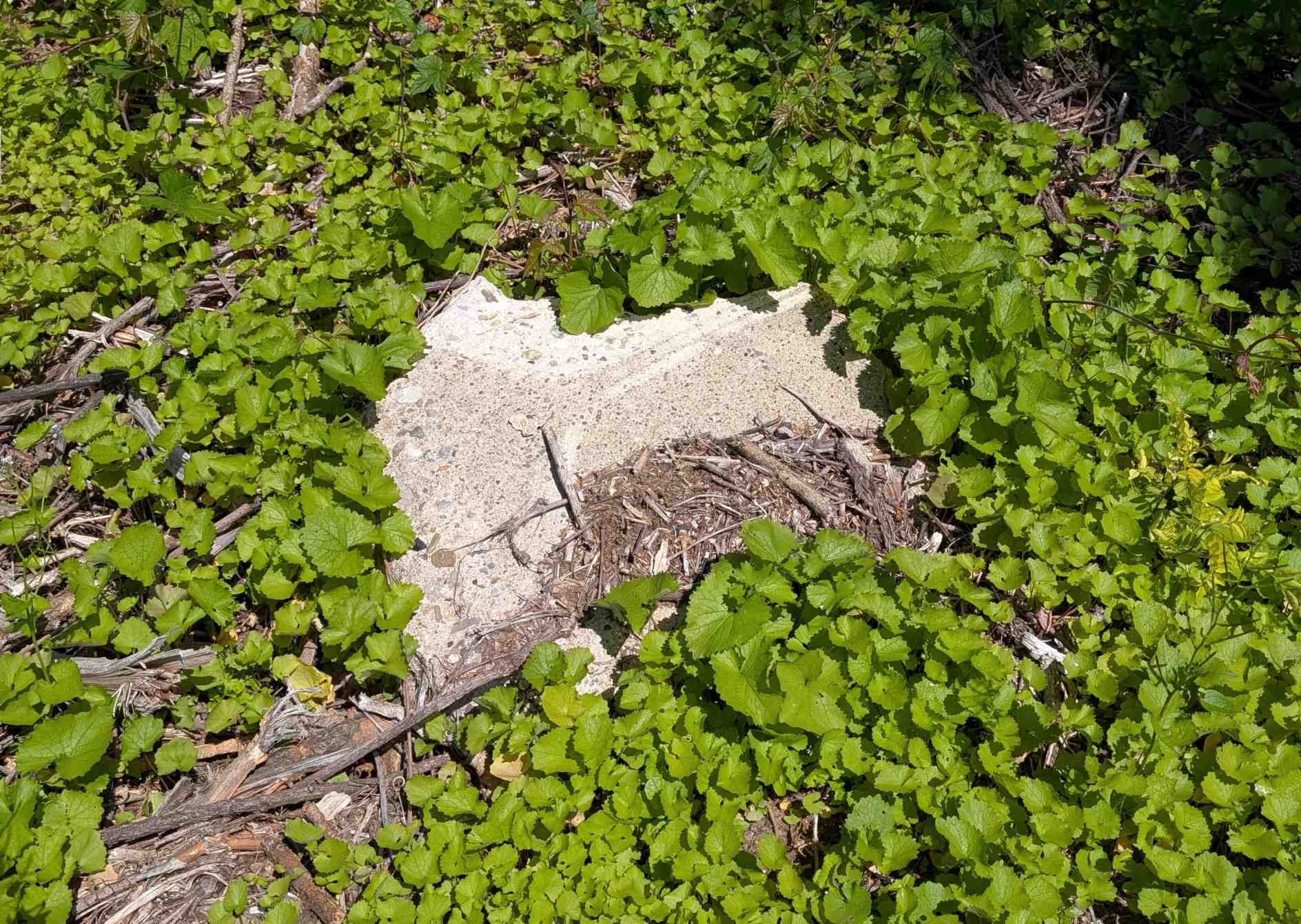
A 5/20/25 photo by Tony Richardson of remains of Morrisville Airport.
Tony reported, “I noticed someone has recently cleared most of the overgrowth surrounding where the former hangar/office had been, uncovering some long-hidden remnants from the airport.
I walked as much as I could & found some remains of the hangar. There is also an old telephone pole still standing, located just east of the hangar.
Not sure what is to become of the property. Only the brush was cleared & most trees remain.”
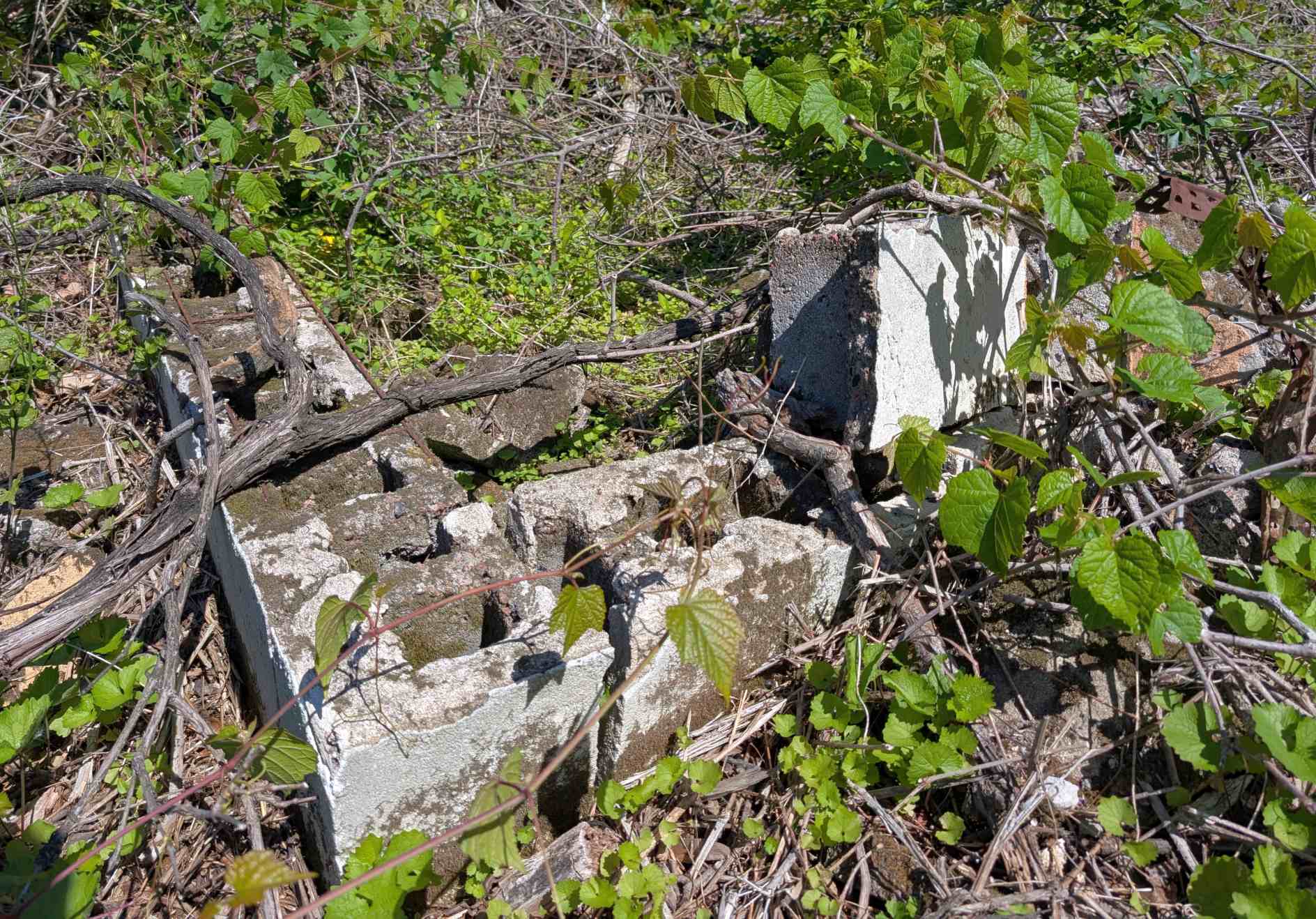
A 5/20/25 photo by Tony Richardson of remains of Morrisville Airport.
The site of Morrisville Airport is located north of the intersection of West Trenton Drive & Lincoln Highway.
____________________________________________________
Silver Star Airport / Old Star Airport, Langhorne, PA
40.18, -74.88 (Northeast of Northeast Philadelphia Airport, PA)
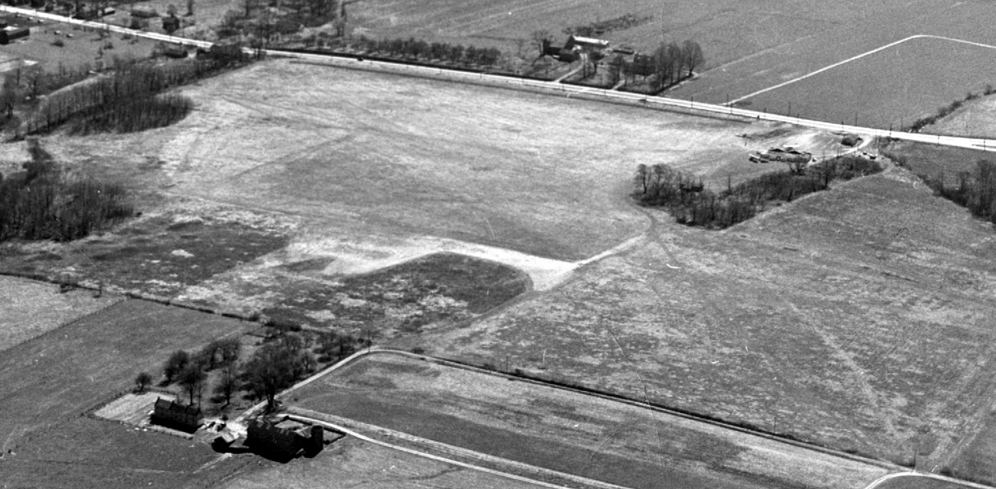
A 1927 aerial view looking southeast at Silver Star Airport (courtesy of Bill Engle Jr.).
The date of construction of this general aviation airport has not been determined.
The earliest depiction which has been located of the Silver Star Airport was a 1927 aerial view looking southeast (courtesy of Bill Engle Jr.).
It depicted Silver Star Airport as being a rectangular grass field with a small 2-bay hangar on the southwest side.
The Jackson Farm was at bottom-left, and Lincoln Highway (Route 1) was seen in the background.
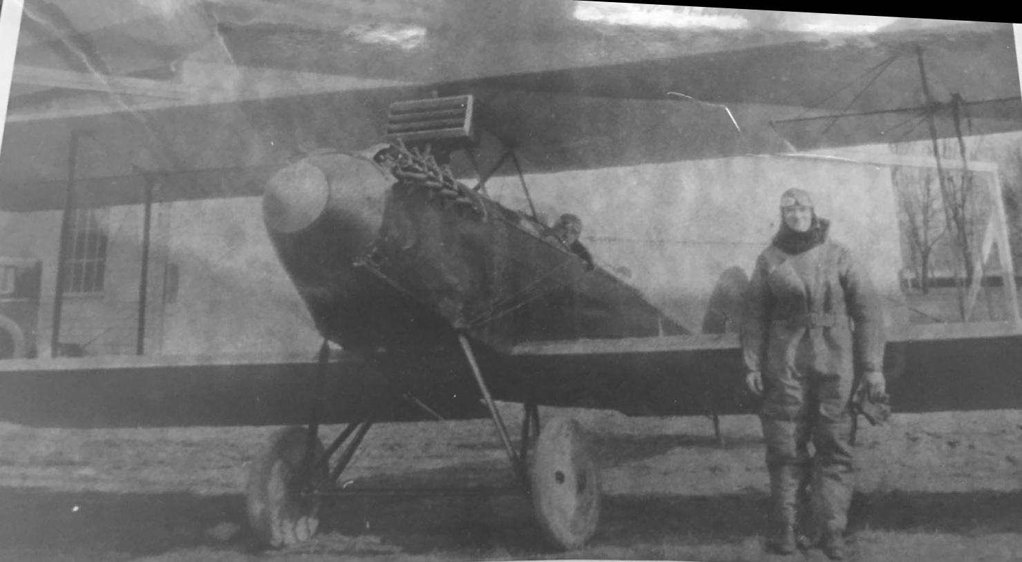
A 1928 photo (courtesy of Bill Engle Jr.) of his father William H. Engle with his Waco 9 biplane at Silver Star Airport.
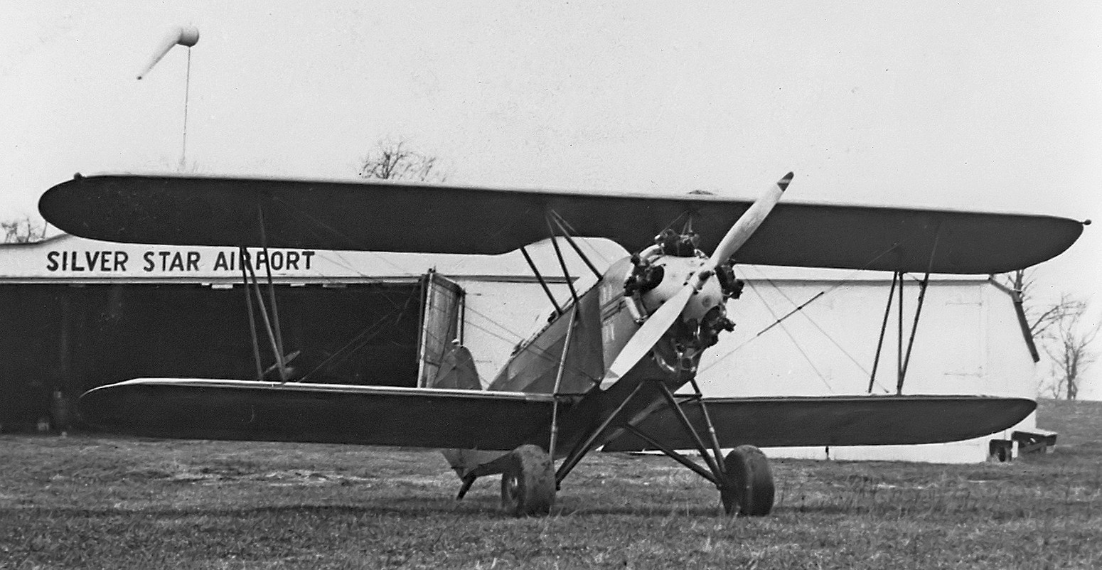
A 1928 photo (courtesy of Bill Engle Jr.) of a Kreider-Reisner Challenger C-2 biplane in front of a Silver Star Airport hangar.
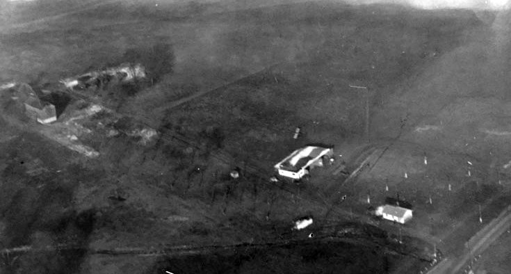
A 1929 aerial view (courtesy of Bill Engle Jr.) of Silver Star Airport, showing a hangar & a small building on the edge of a grass airfield.
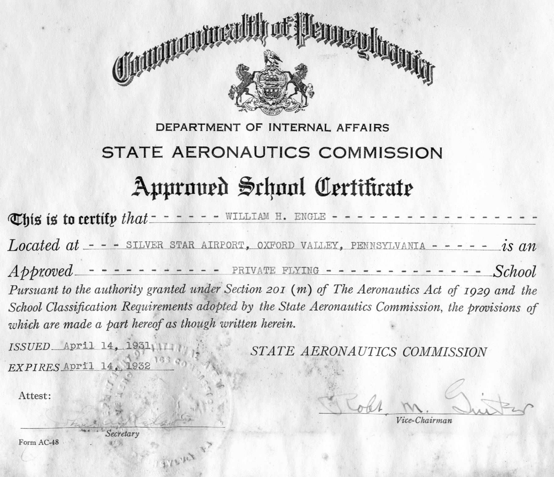
A PA State Aeronautics Commission certificate issued 4/14/31 (courtesy of Bill Engle Jr.) certifying that William H. Engle was an approved Private Flying school at Silver Star Airport.
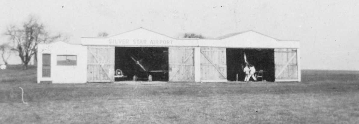
A circa 1930s photo (courtesy of Bill Engle Jr.) of 2 planes inside a hangar labeled “Silver Star Airport”.
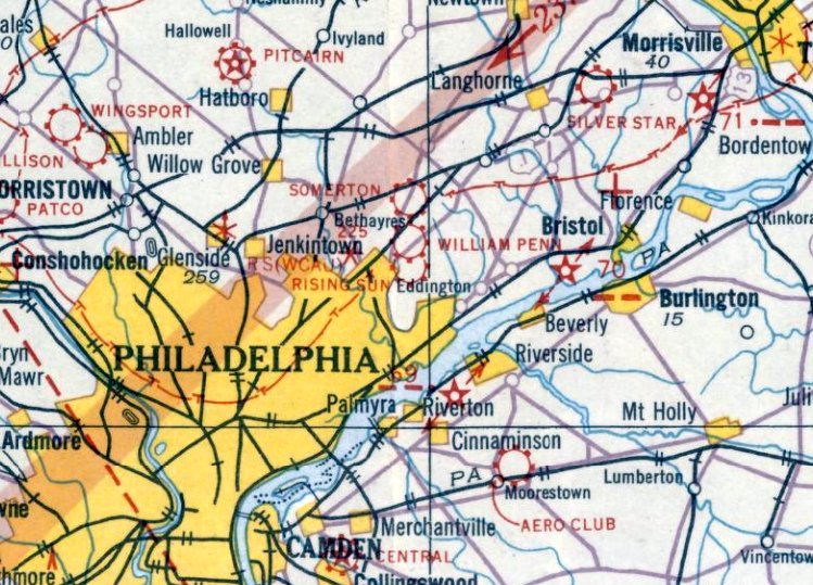
The earliest aeronautical chart depiction which has been located of Silver Star Airport was on the August 1932 NY Sectional Chart.
The earliest airport directory listing which has been located of Silver Star Airport
was in The Airport Directory Company's 1937 Airports Directory (courtesy of Bob Rambo).
It described Silver Star Airport as having two 1,500' sod runways, oriented north/south & northwest/southeast.
A hangar was said to have "Silver Star Airport Langhorne" painted on the roof.
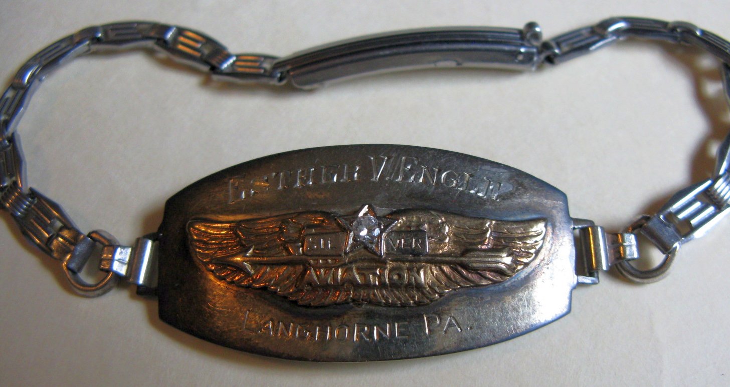
A 3/28/18 photo by Bill Engle Jr. of a bracelet (dated 1937 on the back) engraved “Esther V Engle [his mother], Silver Star Aviation, Langhorne, PA.”
Bill Engle Jr. recalled, “My Dad, William H. Engle, owned the airport at that time.”
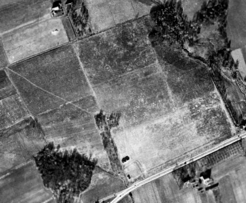
A 1/3/38 aerial photo (courtesy of Chris Kennedy) depicted Silver Star Airport as being an irregularly-shaped grass field,
with an airport circle marking in the northwest corner.
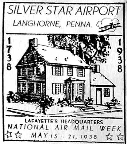
A 1938 postmark commemorating the Silver Star Airport (courtesy of the Langhorne Historical Society, via Jay Cooke).
An article in the 5/5/38 issue of the Delaware Valley Advance (courtesy of the Langhorne Historical Society, via Jay Cooke)
reported of the 1st dispatch of air mail from a local airport, Silver Star Airport.
It was described as a "great historical event".
The 1st air mail flight from Silver Star was said to be conducted by pilot William Engle.
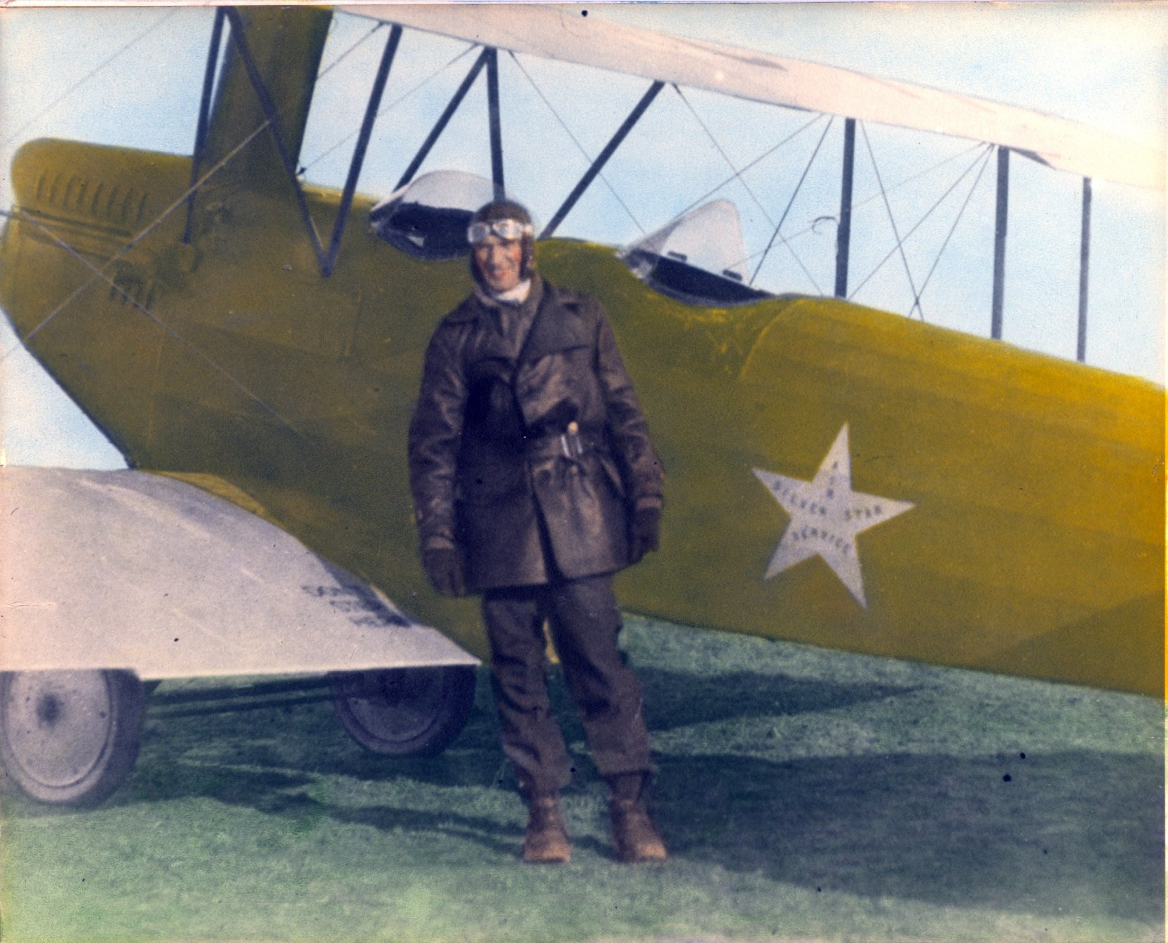
A circa 1930s colorized photo of pilot William Engle in front of a biplane (model unidentified) of Silver Star Air Service (courtesy of Bill Engle Jr).
According to Bill Engle Jr., “The picture might be around the time of the first air mail dispatch mentioned [above].”
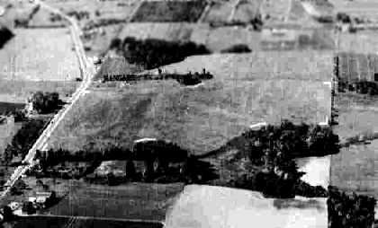
A 10/14/40 aerial view looking southwest at Silver Star Airport from the 1945 AAF Airfield Directory (courtesy of Scott Murdock) depicted the field as an open grass area.
George Erkes recalled, “I had my first airplane ride in 1941 at the Silver Star Airport in a 2-place Taylorcraft piloted by Don Thompson. The airport was then owned by Bill Engle.”
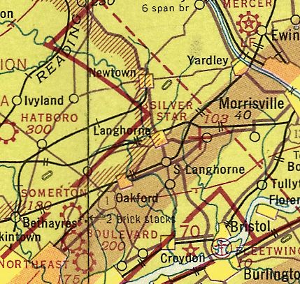
The earliest aeronautical chart depiction which has been located of Silver Star Airport was on the November 1942 NY Sectional Chart (courtesy of Ron Plate),
which depicted Silver Star as an auxiliary airfield.
George Erkes recalled, “From 1942-45 the airport was closed due to the war.”
Silver Star Airport was described in the April 1944 US Army/Navy Directory of Airfields (courtesy of Ken Mercer)
as having a 2,400' unpaved runway.
The 1945 AAF Airfield Directory (courtesy of Scott Murdock) described Silver Star Airport
as an 80 acre irregularly-shaped property within which were 3 sod runways, the longest being a 2,400' northwest/southeast strip.
The field was said to have 2 wood hangars, with the largest measuring 75' x 30'.
Silver Star Airport was described as being privately owned, but not currently in operation.
Silver Star Airport was still depicted on the 1945 NY Sectional Chart (courtesy of Norman Freed).
Bill Engle Jr. recalled, “My Dad, William H. Engle, sold the airport to my Uncle, John VanSant.”
George Erkes recalled, “The airport reopened in 1945 when John VanSant bought the airport & changed the name to Old Star Airport.
He had a very active GI flight school after the war & my brother Bill & I worked there while learning to fly.
We both got our private licenses there in 1946 & Bill worked there as a flight instructor until 1953. I got my multi-engine rating there in 1948.
I remember Rod Jocelyn practicing aerobatics in his Greatlakes biplane before he won the National Aerobatics Championship in 1948.
John VanSant was the Flying Farmer in the J-3 Cub & he put on many airshow demonstrations when he was not hauling passengers in his Waco F & Waco UPF7.”
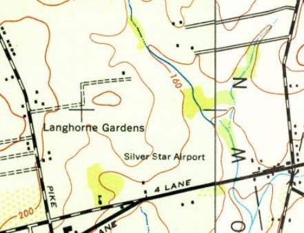
The last depiction which has been located of the field as Silver Star Airport was on the 1947 USGS topo map.
George Erkes recalled, “I have one picture of the airport crew in 1948 with a UC-78 (T-50) in the background.
In the photo we have John & Emma VanSant; flight instructors, Sam Tomlinson, Faust Cappabinco & Bill Erkes; mechanics, John Bushel & Stanley Pratt & Shorty O'Toole & myself.
My brother Frank also worked at the airport in the early 1950s, and he too learned to fly there.”
Lynn Gentzsch recalled, “Silver Star / Old Star... I remember that Stearman & there was also a WWII glider, several Piper Cubs.
All the planes were lined up along Lincoln Highway (Route 1).”
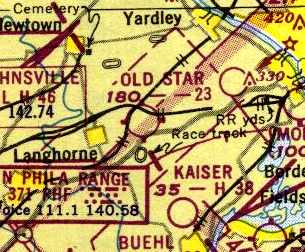
The 1950 NY Sectional Chart (courtesy of Chris Kennedy) depicted Old Star Airport as having a 2,300' unpaved runway.
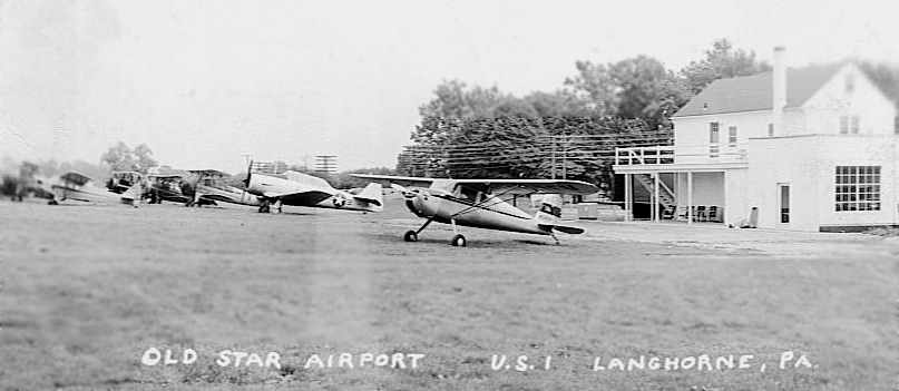
A circa 1940s-50s photo taken from Route 1 looking northwest at several aircraft (including a T-6 Texan) at Old Star Airport
(courtesy of Deborah Jordan, whose father - George Rice - worked at Old Star).
Deborah said, “I remember him taking my brother & I out there when we were real small... in the early 1950s.”
A 1953 aerial view depicted 16 light aircraft at Old Star Airport.
A 1958 aerial view depicted a dozen light aircraft at Old Star Airport.
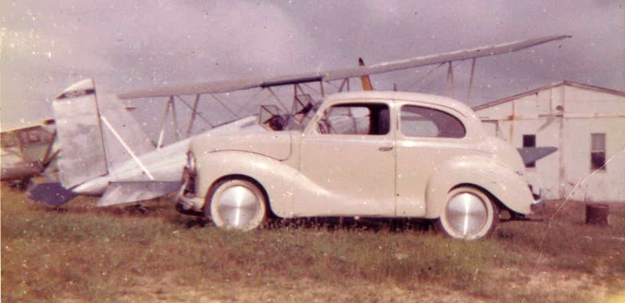
A 1958-59 photo by Ray Clark of his 1953 Austin in front of a Myers OTW biplane & a hangar at Old Star Airport.
Rat recalled, “In 1958 or 1959 I went over to Old Star Airport. I was a Cadet 1st Lt with the Summerton Civil Air Patrol Squadron 1015 checking tail numbers looking for an overdue flight.”
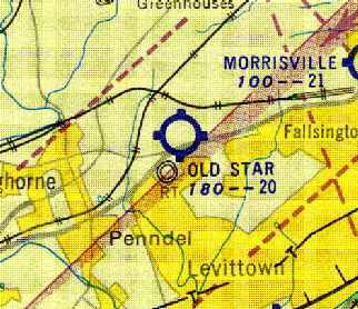
Old Star Airport, as depicted on the 1959 Philadelphia Local Aeronautical Chart (courtesy of Chris Kennedy).
Lindsey Parsons operated a PJ-260 aerobatic biplane from Old Star Airport.
He recalled, "It's home field was Old Star Airport in Langhorne.
The single runway was 2,600', sod, and on about a 2% uphill grade when taking off in a normal prevailing wind.
I could start the roll at the far end of the strip, be airborne about half way up the hill,
half roll the bird at the end of the runway
and immediately push it up through a half outside loop to complete the 'initial climb out'.
This was spectacular performance back in the early sixties!"
Finton Thompson recalled, "I did quite a bit of flying with my uncle out of Old Star Airport in Langhorne.
Old Star was located adjacent on the west side of US Route 1
about one mile north of the intersection of Route 1 & Woodburne Road.
I often rode my bicycle over to Old Star & spent many hours watching the construction of & flying of the PJ-260's.
There was also an old 'character' that flew out of there in his Boeing Stearman - just like an old barnstormer.
Heck, Old Star even hosted airshows & I clearly remember seeing the 'Flying Farmer' routine flown from the rear seat of a J-3 Cub.
My 'passenger' logbook shows flights in & out of Old Star as well as 3M & Buehl Field (Bensalem)
during 1961-62 in a Piper PA-15 Vagabond that belonged to a friend of my uncle's."
Nathan Sturman recalled "Rod Jocelyn, who flew aerobatics out of Old Star."
A 1965 aerial view depicted 22 light aircraft at Old Star Airport.
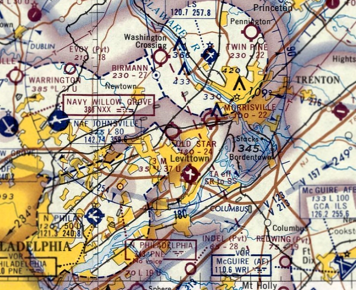
The March 1966 NY Sectional Chart depicted Old Star Airport as having a 2,400' unpaved runway.
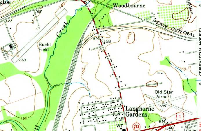
Both Old Star Airport & nearby Buehl Field were still depicted on the 1966 USGS topo map.
Old Star Airport was depicted as having 2 unpaved runways, with a few small buildings on the south side.
It is possible that Old Star Airport may have closed (possibly temporarily) at some point in 1966,
as it was no longer depicted on the September 1966 Philadelphia Local Aeronautical Chart (courtesy of John Ferrara).
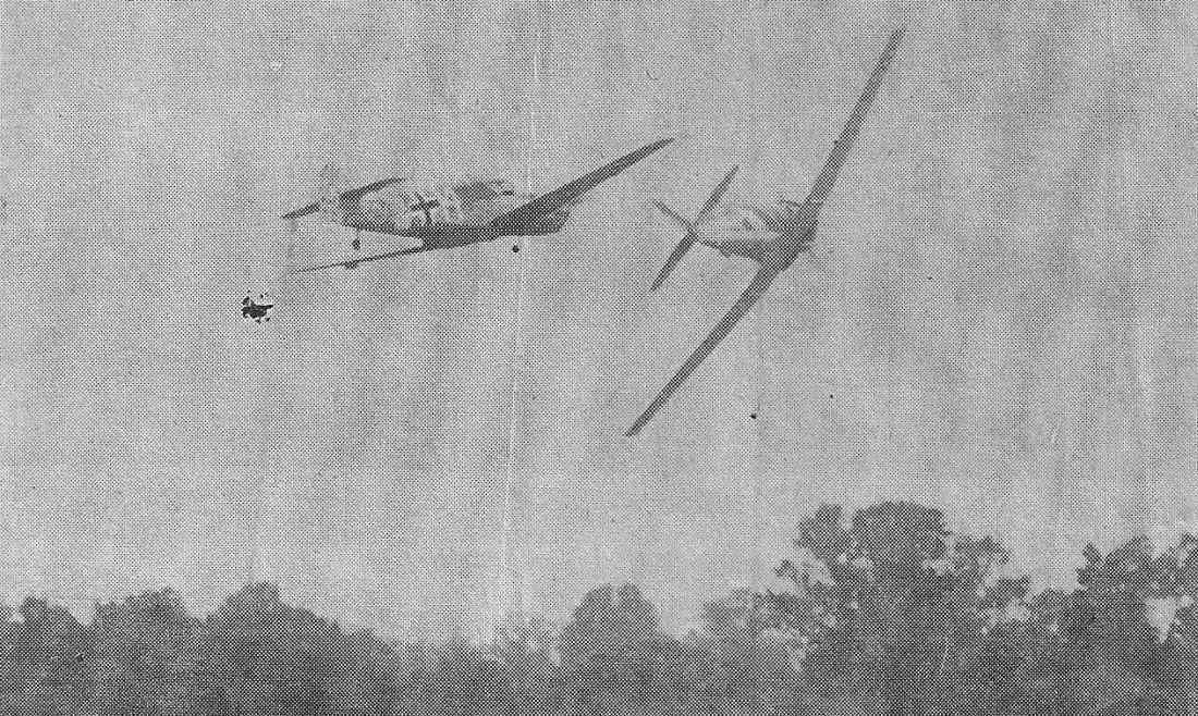
A circa 1966-67 photo from the Langhorne Air Show at Old Star Airport (courtesy of Gary Fitton)
showing a German Messerschmitt Bf 108 tailing a North American AT-6 in British markings.
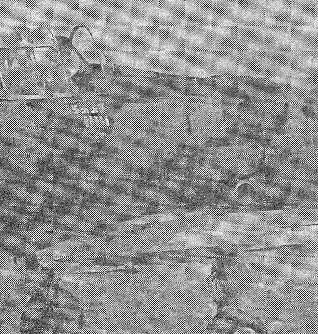
A circa 1966-67 photo from the Langhorne Air Show at Old Star Airport (courtesy of Gary Fitton)
showing Eric Lorentzen bringing in his North American AT-6 in British markings.
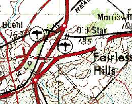
Both Old Star Airport & nearby Buehl Field were still depicted on the 1969 USGS topo map.
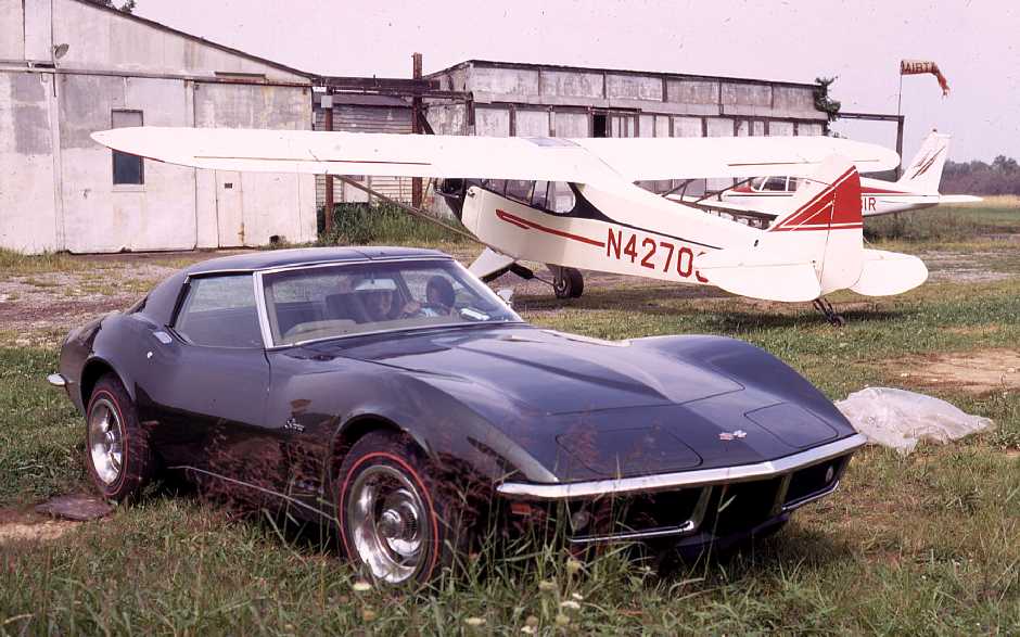
A 1969 photo by Richard Thal of his beautiful 1969 Stingray & his restored J3C65 in front of the old hangar at the top of Old Star's entrance road.
Richard recalled, “Flew 175 hours with that Cub out of Old Star.
I moved the plane to Buehl Field in 1971, because Old Star was closing. The rumor was a mall was to be built.
I still have that 1969 – it looks just as good.”
Gary Fitton recalled, “Old Star... I have some 8mm movies of an airshow there in 1970, with aerobatics in a Chipmunk & a T-33 flyby.
A co-worker had a disassembled Pitcairn PA-18 Autogiro in one of the hangars.”
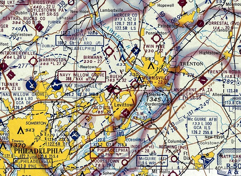
The last aeronautical chart depiction which has been located of Old Star Airport was on the April 1970 NY Sectional Chart.
It depicted the field as having a 2,400' unpaved runway.
Bill Cawthorne recalled, “I was flying at Old Star until 12/5/70. Fred Lewis was my instructor.
The airport 'manager' was C.J. Alexander, who I named my 4th son Alex after.
The tumble-down hangars had a curious collection of aircraft
such as a Pitcairn Autogiro whose fabric was in shreds, a Belanca Viking (3-tailed ) owned by a Mr. Applegate
and a Globe Swift & Stinson Reliant being rebuilt in the large hangar on the hill.
The 'locked' hangar on the hill was home to various parts of what had to be an extreme aerobatic biplane.
I drove the fuel truck during the last airshow there.
At any given time, people would stop by in an array of aviation history.
The engine trailer had pictures of aviation pioneers like Gabby Grabeski by a P-51. I spent my entire high school years there.
I flew a Tripacer N3339Z , a PA-18 Super Cub N9891D, and a PA-28-140 Cherokee N6436R owned by C. J.
I was the airport orphan & if mom wanted to know where I was, she started at Old Star & asked who I was flying with.
The further you got from the hangars on the flightline the less the airplanes saw their owners.
Some were in a sad state. Most were flyable. I arrived with a passion for aviation that has not diminished.”
Tom Barney recalled, “Old Star was still open in the early 1970s; a friend & I were the last pilots to solo from that airport.
Our instructor was Fred Lewis. I think we soloed in 1970 or 1971.”
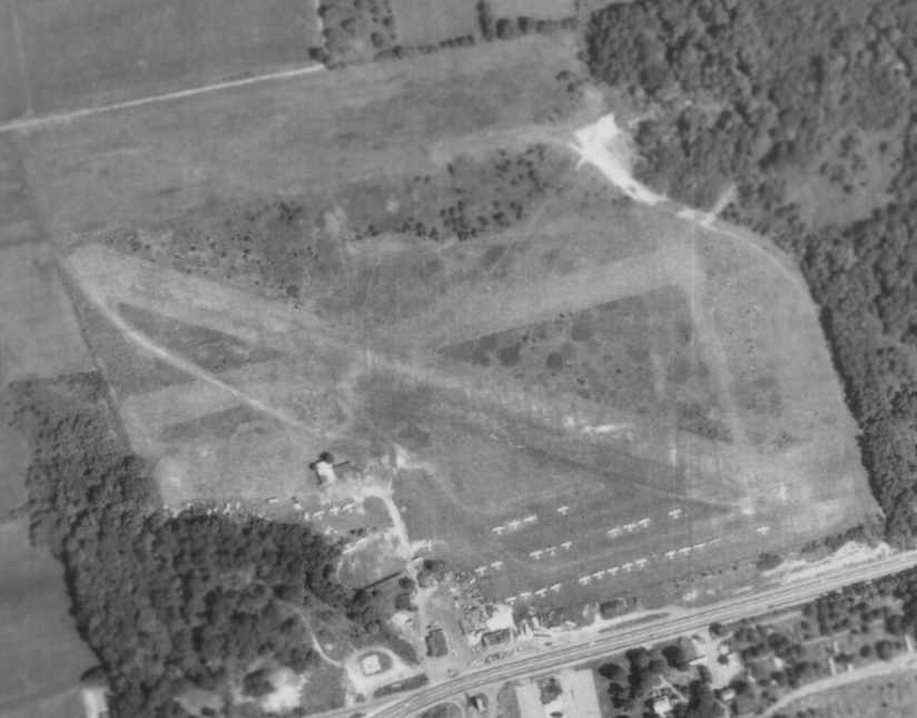
An 8/7/71 aerial view showed Old Star Airport to be very well-used, with a total of over 30 light aircraft visible on the field.
The airfield consisted of 2 grass runways.
Walt Stepek recalled, “On a weekend afternoon as I drove down Route 1 I heard a roar,
looked to my right & saw a P-51 going straight up into the air (or so it seemed, anyway).
It turned out there was an airshow at Old Star airport that day, and judging by the time it must have been the last ever there.”
Lynn Gentzsch recalled, “When he [Johnny VanSant] sold out to the Oxford Valley Mall, he opened VanSant Airport in Erwinna.”
Old Star Airport evidently was closed at some point between 1971-73,
as it was no longer depicted on the January 1973 NY Sectional Chart,
and the 1973 USGS topo map showed that the Oxford Valley Mall had been built just north of the former Old Star Airport,
which was no longer depicted.
The 1994 USGS aerial view showed the Oxford Valley Mall which had been built just north of the former Old Star Airport,
of which no obvious trace remained.
Jay Cooke reported in 2001 that "The stone farm house used as an [airport] office is still there on a used car lot."
There do not appear to be any other remaining traces of Old Star Airport.
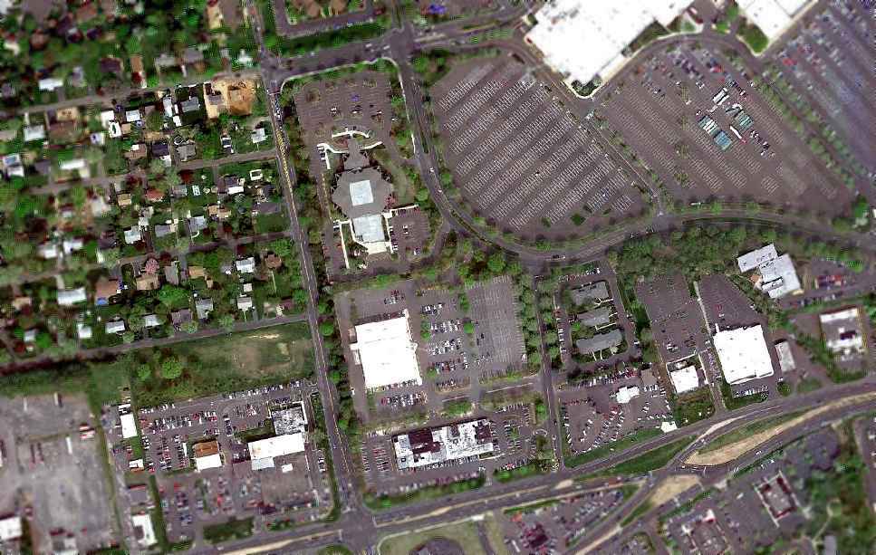
A 4/10/10 aerial view of the site of Old Star Airport did not depict any trace of the former airport.
The site of Old Star Airport Airport is located north of the intersection of Woodbourne Road & Maple Avenue,
just south of the Oxford Valley Mall.
____________________________________________________
Buehl Field (Bensalem location), Bensalem, PA
40.095, -74.94 (Northeast of Philadelphia, PA)
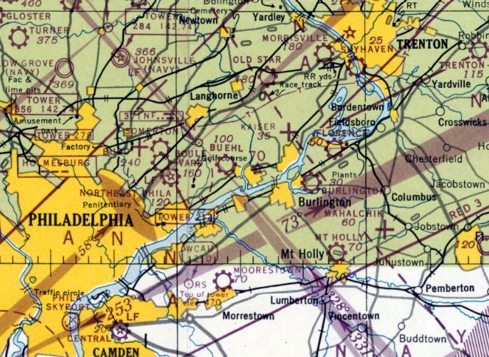
Buehl Field, as depicted at is original location in Bensalem on the January 1947 NY Sectional Chart.
The original location of Buehl Field was on the southeast corner of Street Road & Hulmeville Road in Bensalem.
According to Mark Taylor, Ernest Buehl “purchased the property in 1941.”
Buehl Field was not yet depicted on the July 1946 NY Sectional Chart, or the 1947 USGS topo map.
The earliest depiction of Buehl Field which has been located was on the January 1947 NY Sectional Chart.
According to Mark Taylor, Buelh Field “opened 3/1/47.”
Buehl Field was operated by Flying Dutchman Air Service,
whose manager, Ernest Buehl, also operated nearby Somerton Airport until Febrtuary 1952.
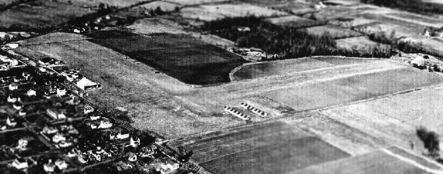
A 1952 aerial view looking north at Buehl Field (courtesy of Laurie VanSant)
depicted the field as having 2 grass runways, with 2 hangars along the west side of the field & 2 on the southeast.
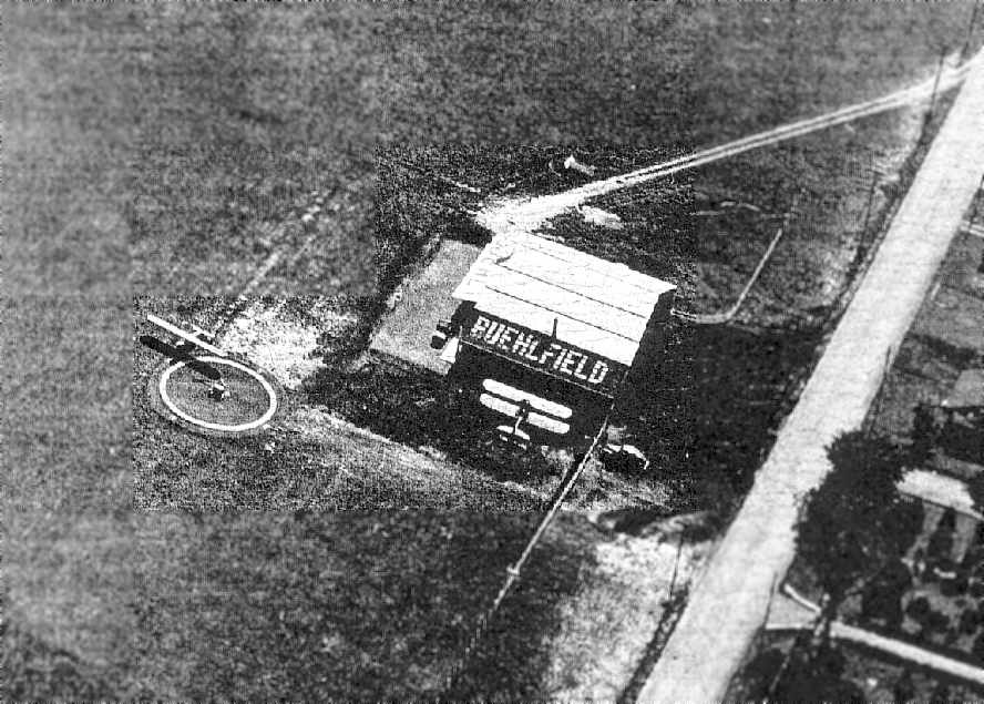
A 1952 aerial view of a hangar marked “Buehl Field” (courtesy of Laurie VanSant)
with a biplane & a monoplane parked nearby.
A 1953 aerial view depicted Buehl Field as having 2 grass runways, with 3 hangars along the west side of the field & 2 on the southeast.
A total of 3 single-engine aircraft were visible on the field.
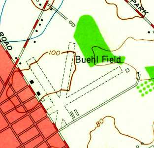
The 1955 USGS topo map depicted Buehl Field as having 3 unpaved runways, with 3 hangars along the west side of the field & 2 on the southeast.
The 1957 Washington Sectional Chart (courtesy of Mike Keefe) described Buehl Field as having 3 turf runways,
with the longest being the 2,500' north/south strip.
The operator was listed as Flying Dutchman Air Service, and the manager was listed as Ernest Buehl.
The Aerodromes table on the 1958 NY Sectional Chart (courtesy of Norman Freed)
described Buehl Field as having a total of 4 turf runways, with the longest being a 2,700' strip.
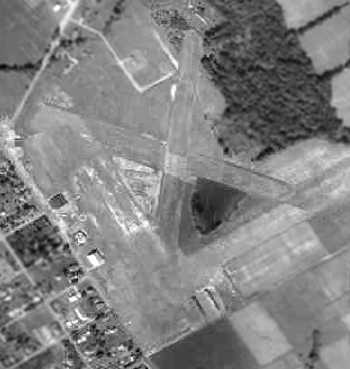
A 1958 aerial view depicted Buehl Field as having 2 grass runways,
with 2 hangars along the west side of the field & 2 on the southeast, and 7 light aircraft were visible.
According to Mark Taylor, Ernest Buehl's sale of Buehl Field “was announced on 8/10/60.”
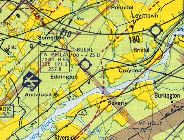
The last depiction which has been located of the original Buehl Field
was on the 1961 Philadelphia Local Aeronautical Chart (courtesy of Tim Zukas).
It depicted Buehl Field as having a 2,500' unpaved runway.
Buehl Field was apparently closed at this location at some point between 1961-63,
as it was no longer depicted on the October 1963 Philly Local Aeronautical Chart (courtesy of Boom Powell).
A 1965 aerial view showed that all except one of Buehl's hangars had been removed at some point between 1958-65,
and residential construction had begun on the eastern half of the airport property.
A 1967 aerial view showed that the last hangar had been removed at some point between 1965-67,
and houses covered the eastern half of the site.
But the runway intersection was still visible on the western half,
as the last recognizable remnant of Buehl Field.
By 1967 Buehl Field had reopened at a new location in Woodbourne (5 miles to the northeast).
By the time of a 1970 aerial photo, the original location of Buehl Field had been redeveloped as the Brookwood Shopping Center & a housing development,
with not a trace remaining of the former airport.
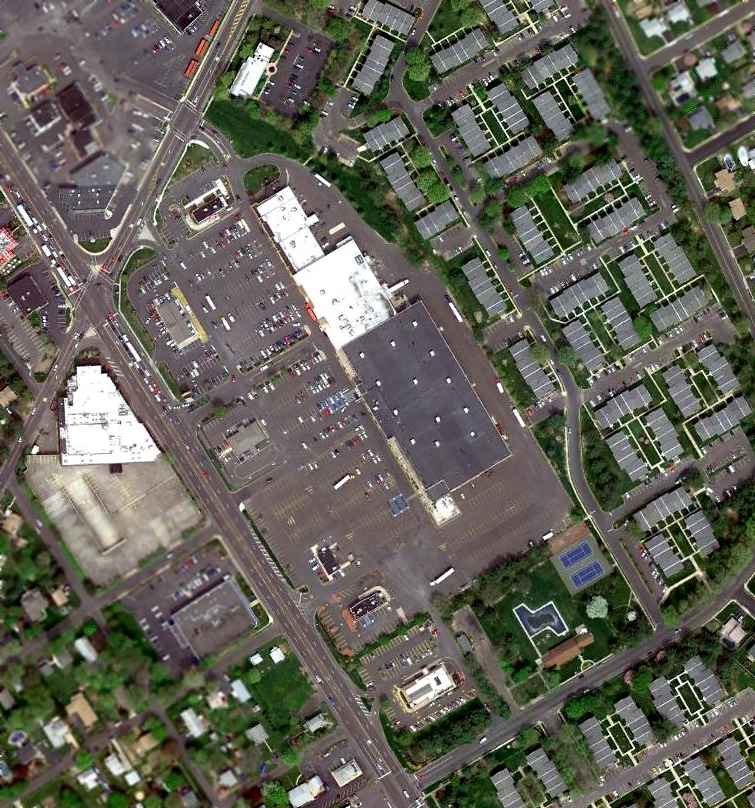
A 4/12/10 aerial photo shows that the site has been densely redeveloped,
with no trace remaining of the airfield.
____________________________________________________
Buehl Field (N54) (Woodbourne location), Woodbourne, PA
40.189, -74.9 (Northeast of Philadelphia, PA)
Both Buehl Field & nearby Old Star Airport were depicted on the 1966 USGS topo map.
A 1958 aerial view did not yet depict an airfield at this location.
According to Mark Taylor, Ernest Buehl purchased the Buehl Field Woodbourne “land in December 1960, and took full possession in December 1961.
Buehl planned to open 6/15/62.
He had support from FAA, AOPA, the PA State Aviation Commission, the Aviation Council of Pennsylvania, the Civil Air Patrol,
and the Middletown Township Commercial & Industrial Development Commission but the Township Board of Supervisors blocked approval.
The runway was paved in 1964 but was not completely finished because Buehl was blocked by the Township.”
The earliest depiction which has been located of Buehl Field in Woodbourne was a 1965 aerial view,
which depicted a single unpaved northeast/southwest runway, with a single hangar on the northwest side.
No aircraft were visible on the field.
The March 1966 NY Sectional Chart (courtesy of Mike Keefe) did not yet depict an airfield at this location.
The earliest topo map depiction which has been located of Buehl Field at this location was on the 1966 USGS topo map.
It depicted Buehl Field as having a single paved northeast/southwest runway, with a building on the northwest side.
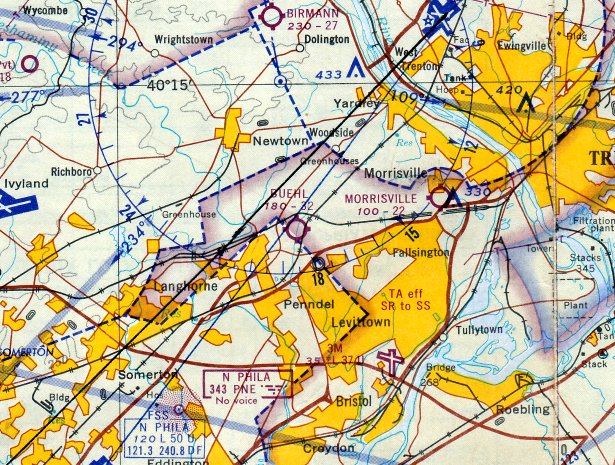
The earliest aeronautical chart depiction which has been located of Buehl Field at this location
was on the October 1966 Philadelphia Local Aeronautical Chart (courtesy of John Ferrara).
It depicted Buehl as having a 3,200' unpaved runway.
The Aerodromes table on the March 1967 NY Sectional Chart (courtesy of Mike Keefe) described Buehl as having a single 3,250' turf Runway 4/22.
According to Jay Cooke, the Flying Dutchman Air Service began operating at Buehl Field in Woodbourne in approximately 1967,
after having relocated from the original Buehl Field location in Bensalem (5 miles to the southwest).
According to Mark Taylor, “It was late 1967 that the township agreed to a plan to open the airport, but this was challenged again in 1968.”
The runway at Buehl was paved at some point within the next 3 years,
as the 1970 Washington Sectional Chart (courtesy of John Clifford) depicted Buehl as having a 3,200' paved runway.
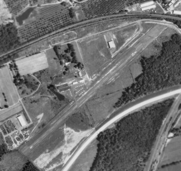
An 8/7/71 aerial photo depicted Buehl Field as having a single paved Runway 6/24,
with several hangars on the northwest side of the field, and over 20 light aircraft visible on the field.
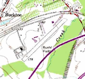
Buehl Field was depicted on the 1973 USGS topo map as having a single paved northeast/southwest runway,
and several buildings along the north side of the field.
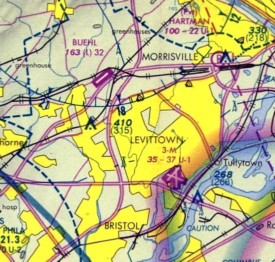
The February 1975 Philadelphia Terminal Aeronautical Chart (courtesy of Mitchell Hymowitz)
depicted Buehl Field as having a single 3,200' paved runway.
According to Bob Zambelli, "I did my instrument checkride at Buehl Field at its last location.
I was signed off by Beth-Ann Buehl, a very competent & attractive lady
who was one of the most enthusiastic 'airplane people' I've ever met."
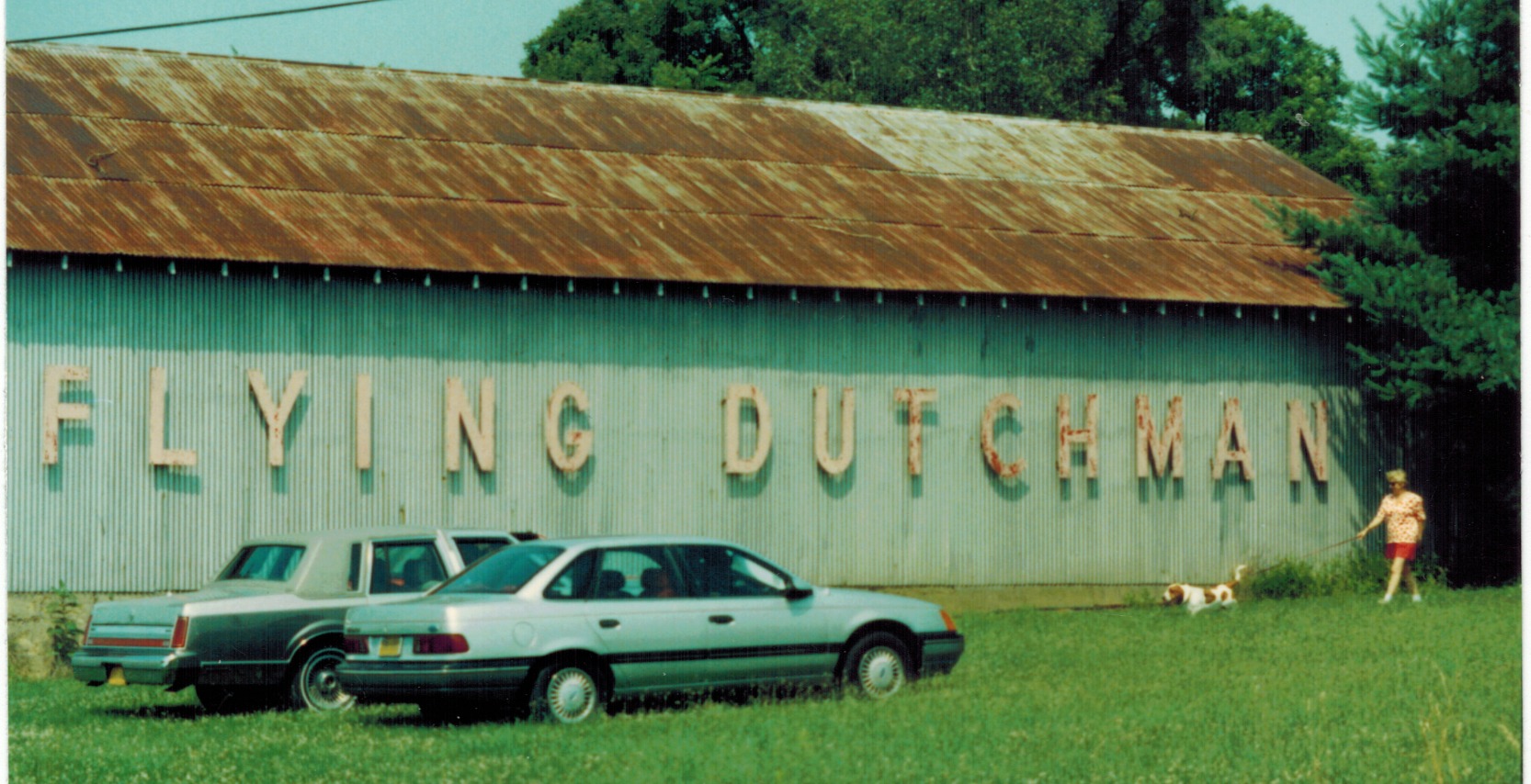
A September 1991 photo of Marybeth Campbell walking Fred in front of the Flying Dutchman sign at Buehl Airport (courtesy of Paul Campbell).
Paul Cambell also recalled, “The Buehl's had a pair of dachshunds that ran free on the airport property chasing whatever they could find.”
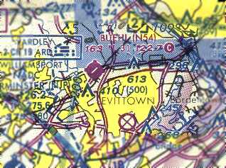
The March 1993 Washington Sectional Chart (courtesy of Carl Taylor) depicted Buehl Field as having a single 3,200' paved runway.
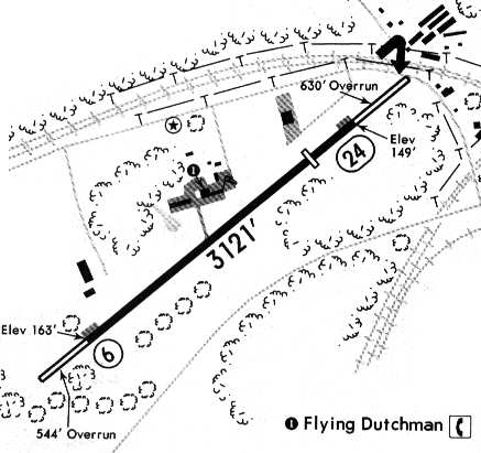
A 1994 airport directory depicted Buehl Field as having a single paved 3,121' Runway 6/24,
along with a paved ramp & a small group of hangars north of the runway.
The operator was listed as Flying Dutchman.
According to Tom Kramer, "In 1995 I actually was going to base my Skyhawk there [at Buehl] & spoke to them.
However, their fuel prices were outrageous & I looked elsewhere."
The 1995 Jeppesen Airport Directory depicted Buehl Field as having a single paved 3,121' Runway 6/24,
along with a paved ramp & a small group of hangars north of the runway.
The operator was listed as Flying Dutchman.
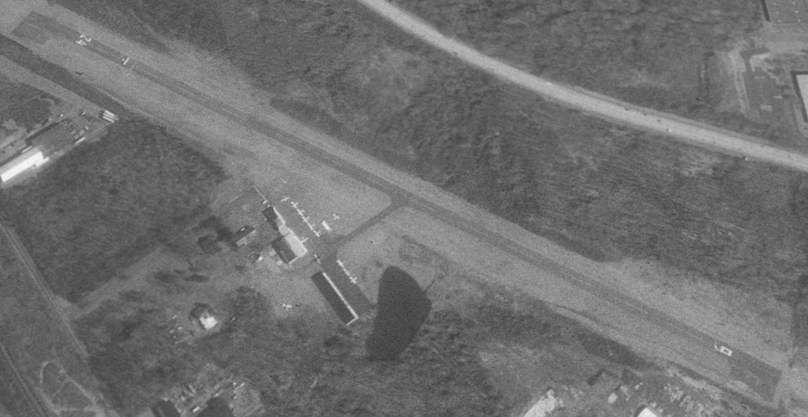
A 5/13/95 USGS aerial view looking east showed Buehl Field to be quite healthy, with a total of 13 planes visible outside, including one taking off on Runway 24.
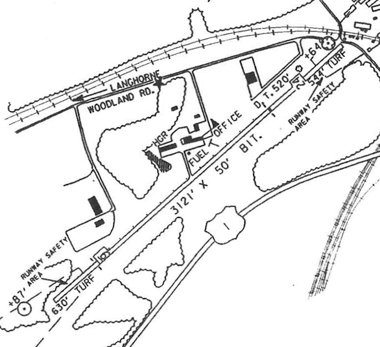
The last airport directory listing which has been located of Buehl Airport was in the 1997 PA Airport Directory (courtesy of John Clifford).
It depicted Buehl as having a 3,121' bituminous Runway 6/24.
The operator was listed as Flying Dutchman Air Service & the manager as Ernst Buehl, Jr.
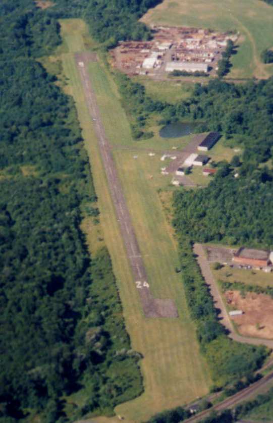
A beautiful 1998 aerial picture looking west at Buehl Field (shortly before its closure) by Philip Kineyko.
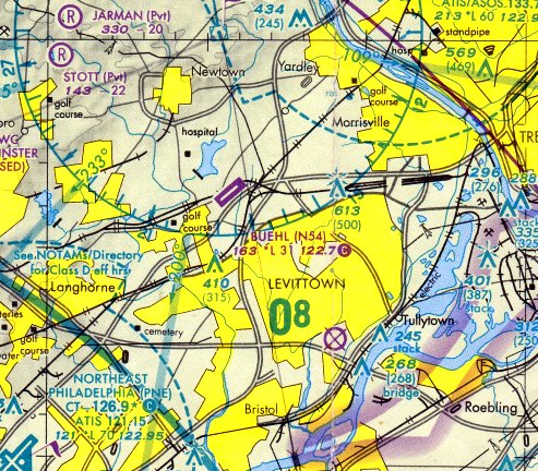
The last aeronautical chart depiction which has been located showing Buehl Field still open was on the August 1998 Philadelphia Terminal Aeronautical Chart (courtesy of John Ferrara).
It depicted Buehl Field as having a single 3,100' paved northeast/southwest runway.
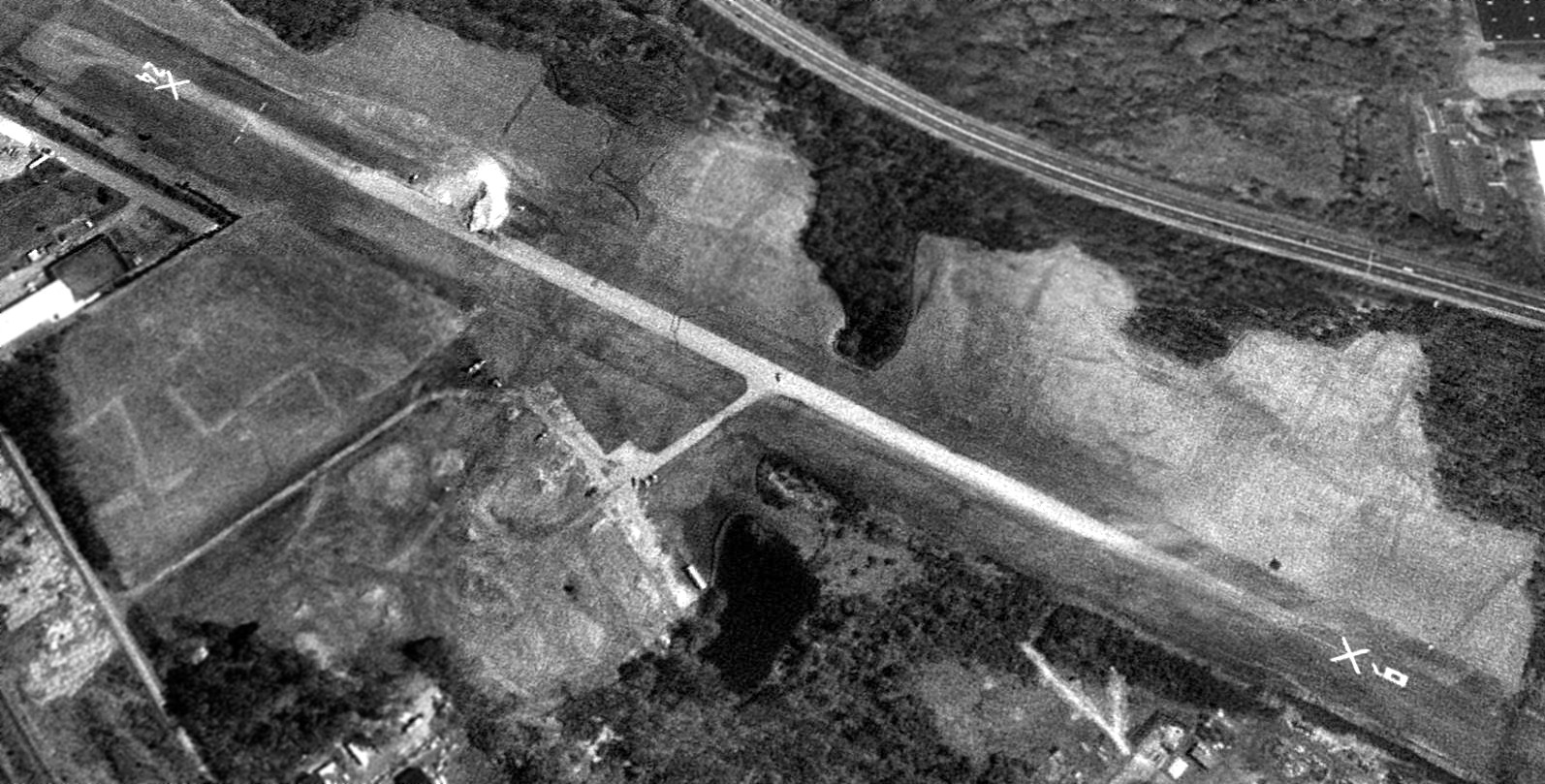
Buehl Field became yet another vanished suburban general aviation airport, as it closed at some point between 1998-99,
as a 4/13/99 aerial view looking east showed Runway 6/24 marked with closed-runway “X” symbols,
and all of the hangars & other airport buildings had been removed at some point between 1998-99.
It was labeled "Buehl (Closed)" on the 2000 Washington Sectional Chart (courtesy of Mike Keefe).
According to Tom Kramer, "I understand that the reason it closed
was that the original owners died off & the family didn't want to run an airport anymore.
They sold out to the builders of the Senior Citizen housing complex.
It took about a year for the airport to entirely cease to exist. Nothing remains."
A 3/5/02 aerial view of the site showed that housing had covered the site of Buehl Airport.
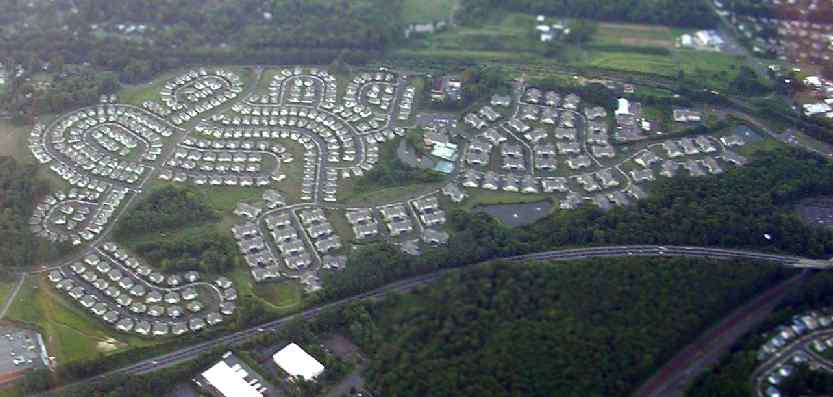
A September 2005 aerial view by Tom Kramer, looking northwest at the site of Buehl Field.
The property has been completely redeveloped as a senior development,
the Village at Flowers Mill, with no trace remaining of the airfield.
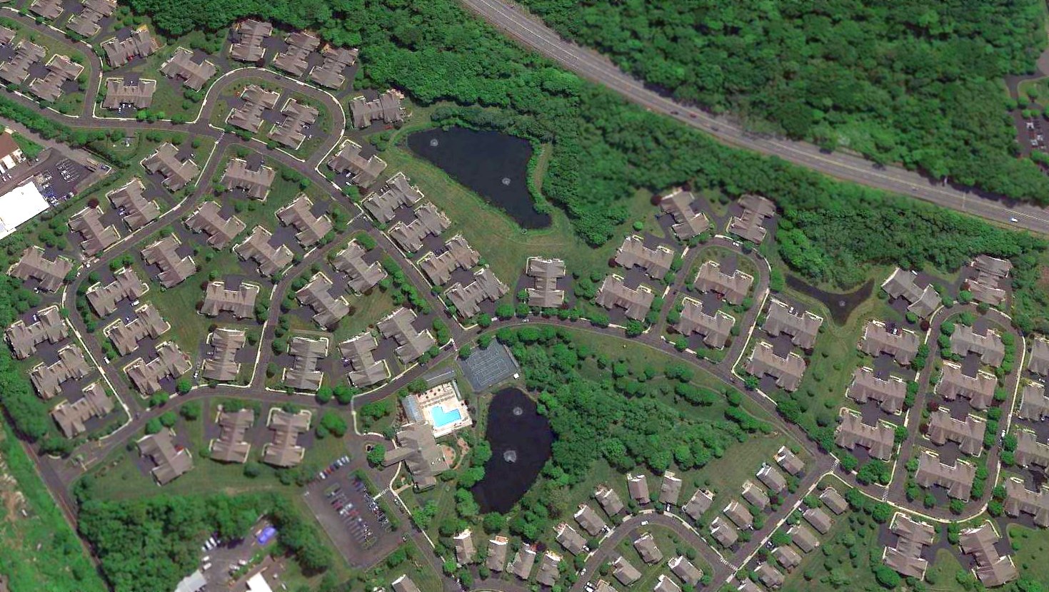
A 2016 aerial view looking east showed no trace remaining of Buehl Field.
Yet another of America's hundreds of grassroots airports swallowed by our insatiable demand for more housing.
The site of Buehl Field is located west of the intersection of Route 1 & Woodbourne Road.
____________________________________________________
Keystone / Fleetwings Factory & Seaplane Base, Bristol, PA
40.11, -74.84 (Northeast of Philadelphia, PA)
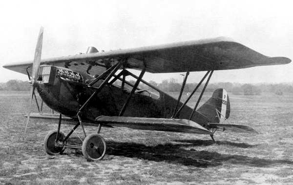
An undated photo of the Huff-Daland AT-1, produced in 1925.
This aircraft manufacturing factory along the Delaware River
has gone through a confusing series of owners & corporate names.
Thomas Huff & Elliot Daland formed the Huff Daland Aero Corporation in 1925 in Bristol PA.
Huff Daland produced a series of biplanes as trainers, observation planes, and light bombers, for the Army & Navy.
In 1927, the Huff Daland Aero Corporation was taken over by Hayden, Stone & Co, an NYC brokerage firm,
and in the same year in the course of a merger, it became the Huff-Daland Division of the Keystone Corporation.
Some of the Huff-Daland designs were floatplanes, and thus could be operated from the Delaware River adjacent to the Bristol factory.
However, many of their designs were landplanes.
An airfield for landplanes (known at various times as Keystone / Kaiser / 3M Airport) was eventually constructed just one mile north of the Bristol plant.
Within 1927, the Huff-Daland Division of the Keystone Corporation was known as the Keystone Aircraft Corporation.
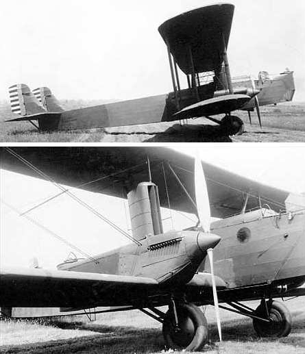
An undated photo of the Keystone XB-1B, produced in 1927.
In 1927, a single example of the Huff-Daland XB-1 bomber became the Keystone XB-1B,
after its original Packard 2A-1530 engines were replaced with Curtiss V-1570-5 "Conqueror" engines.
The improved -B aircraft had better performance than the original,
but still didn't compare favorably to other aircraft of the period & never entered production.
Keystone merged with the Loening Company of NY in 1928.
According to Tom Beamer, the Fleetwings Corporation was organized in 1929,
and soon thereafter became a tenant of Keystone at the Bristol plant.
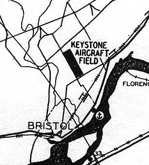
The earliest chart depiction of the Fleetwings Seaplane Base that has been located was on the Philly Chamber of Commerce's
1930 "Aviation Map of the Philadelphia Metro District" (courtesy of Tom Beamer).
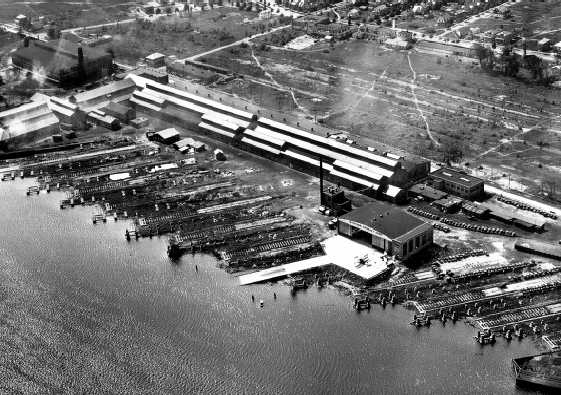
The earliest photo which has been located of the Keystone aircraft factory & seaplane base was a 9/11/30 aerial view looking west (courtesy of Tom Beamer).
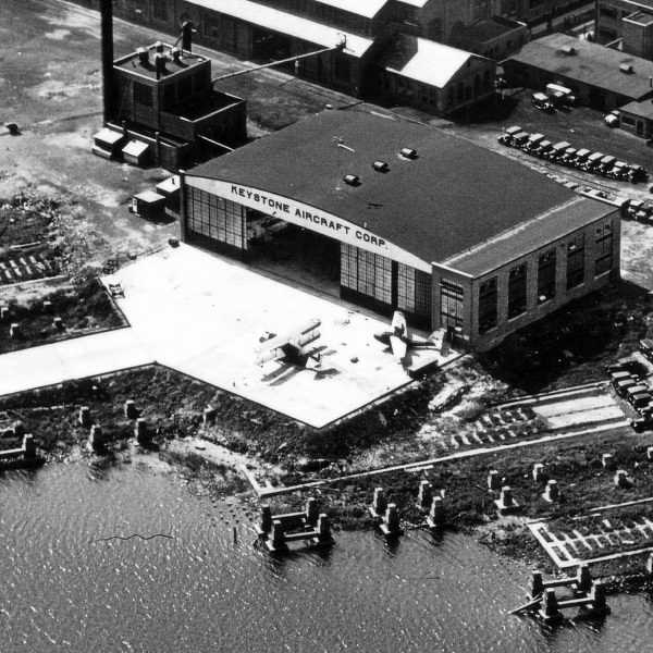
A closeup from the 9/11/30 aerial view of what appears to be a Keystone-Loening Commuter seaplane & a biplane
on the ramp in front of the hangar (courtesy of Tom Beamer).
By 1931, Keystone had become the Keystone Aircraft Division of the Curtiss-Wright Corporation.
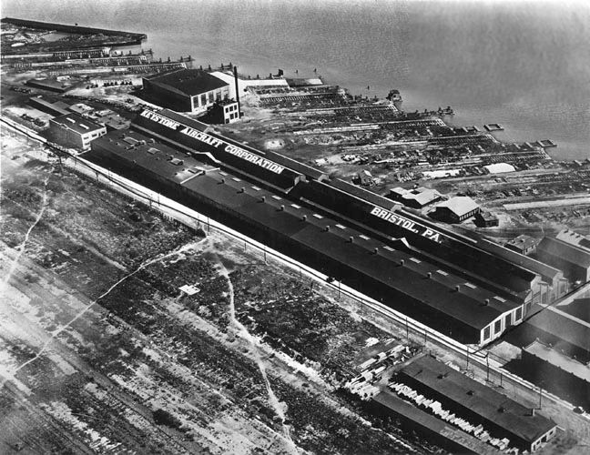
A circa 1930s aerial view (courtesy of Alan Reddig) looking east at “the Keystone (later Fleetwings) factory on the river at Bristol.
The seaplane hangar & ramp are at the upper left corner.”
In 1934, Keystone's parent, Curtiss-Wright, moved operations elsewhere, and the Keystone factory was sold to the Fleetwings Corporation.
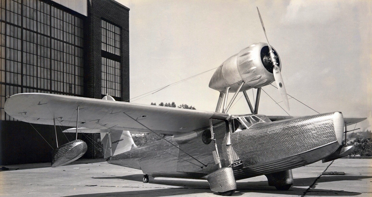
The earliest photo which has been located of an aircraft at the Fleetwings Seaplane Base was a 1937 photo (courtesy of Bill Engle Jr.) of the beautiful Fleetwings F-4 Sea Bird prototype NX16793 C/n F-401 on the Bristol hangar apron.
Bill noted, “The skin was 0.010 thick stainless steel & was given a swirl finish to make it look attractive. “
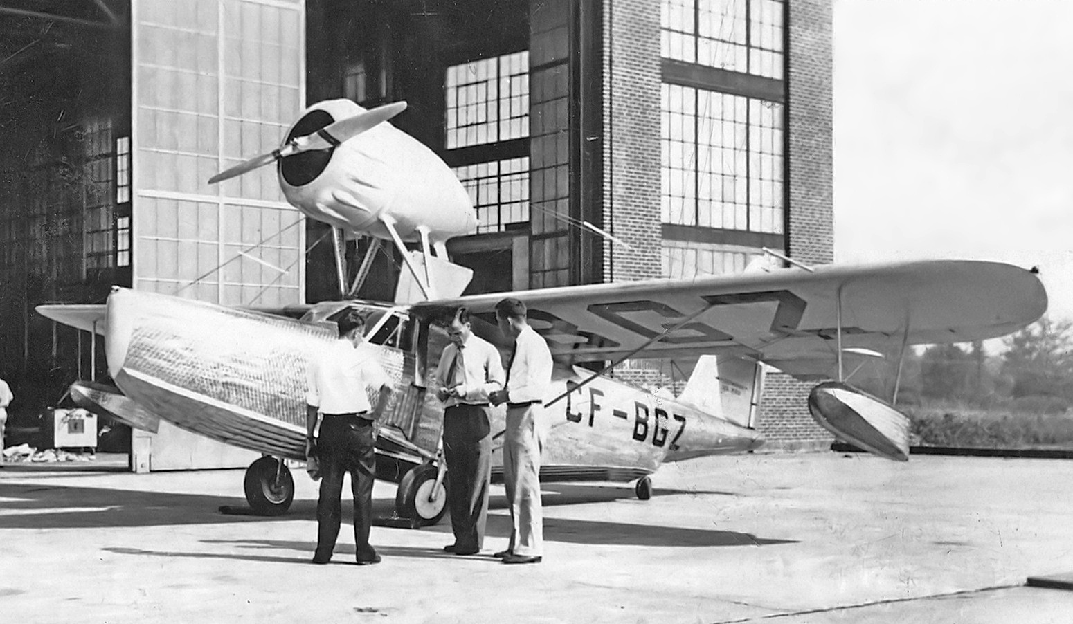
An August 1937 photo (courtesy of Bill Engle Jr.) of Fleetwings F-4 Sea Bird CF-BGZ C/n F-401 on the Bristol hangar apron.
Bill noted it was “here on the Fleetwings seaplane ramp prior to delivery. It was registered to Northern Ventures Ltd of Fort St James, BC initially.”
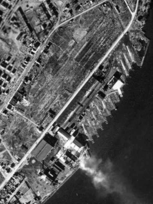
A 12/29/37 aerial view of the Fleetwings facility.
The Fleetwings Seaplane Base was not yet depicted on the April 1938 NY Sectional Chart.
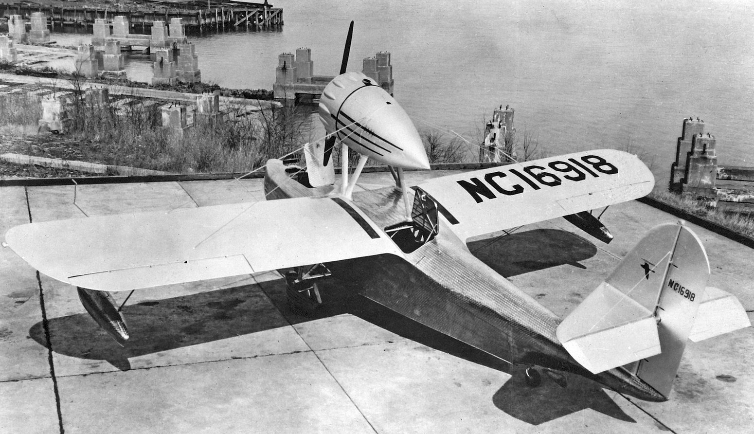
The last photo which has been located of an aircraft at the Fleetwings Seaplane Base was a 1938 photo (courtesy of Bill Engle Jr.) of Fleetwings F-5 Sea Bird NC16918 C/n F-501 on the Bristol hangar apron.
Bill noted, “The F-5 was a modified version of the F-4 with accommodation for 5 occupants (instead of 4).
Here it is parked on the Fleetwings seaplane ramp with both the nose mooring hatch & passenger access hatch open.”
Herb Twining recalled, “Upon graduating Langhorne-Middletown High School in 1938 I went to Lock Haven & worked at Piper for a bit,
from there to Glenn L. Martin in Baltimore for a few months, and then back to Bristol working in Fleetwings.
I worked there until I enlisted in the USAAC, 9/1/42. While at Fleetwings I worked in sheet metal departments, finally building wings for the Grumman Avenger.
Only a couple names come to my mind now, Bill Engle & John Scheppe. Bill was the pilot for the Seabird.
It would go down the ramp from the hangar into the Delaware River, take off, fly & return & backup the ramp to the hangar.”
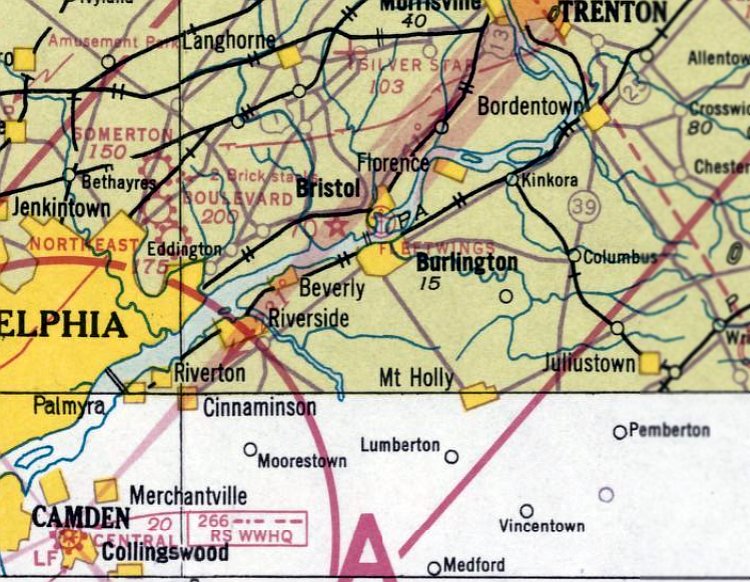
The earliest aeronautical chart depiction which has been located of the Fleetwings Seaplane Base was on the November 1938 NY Sectional Chart.
Bill Engle Jr. recalled, “Dad [William Engle] demonstrated Fleetwings Seabird F502 to Howard Hughes in Nassau in 1939. I remember him telling me about it.”
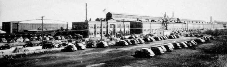
A circa 1930s-40s photo looking south at the Fleetwings seaplane hangar & aircraft factory.
Fleetwings built a new factory in 1941 on Green Lane at the Keystone / Kaiser / 3M Airport,
and all aircraft assembly was performed at the new factory at the airport from that point on.
However, this was not the end of their use of the Bristol factory,
as Fleetwings also performed quite a bit of aircraft component manufacturing under sub-contract during WW2,
including work for Curtiss-Wright, Republic, Martin, Vought, Brewster, Grumman and others.
They advertised sub-contracting with their large line of hydraulic metal forming equipment,
which most likely remained at the Bristol location (not relocated to the new factory built at the airfield 1941).
According to Tom Beamer, the Fleetwings Corporation was purchased by Kaiser in 1943,
becoming the "Fleetwings Division of Kaiser Cargo Inc.".

The last aeronautical chart depiction of the Fleetwings Seaplane Base that has been located was on the January 1945 NY Sectional Chart.
The Fleetwings Seaplane Base was evidently closed at some point in 1945,
as it was no longer depicted on the June 1945 NY Sectional Chart.
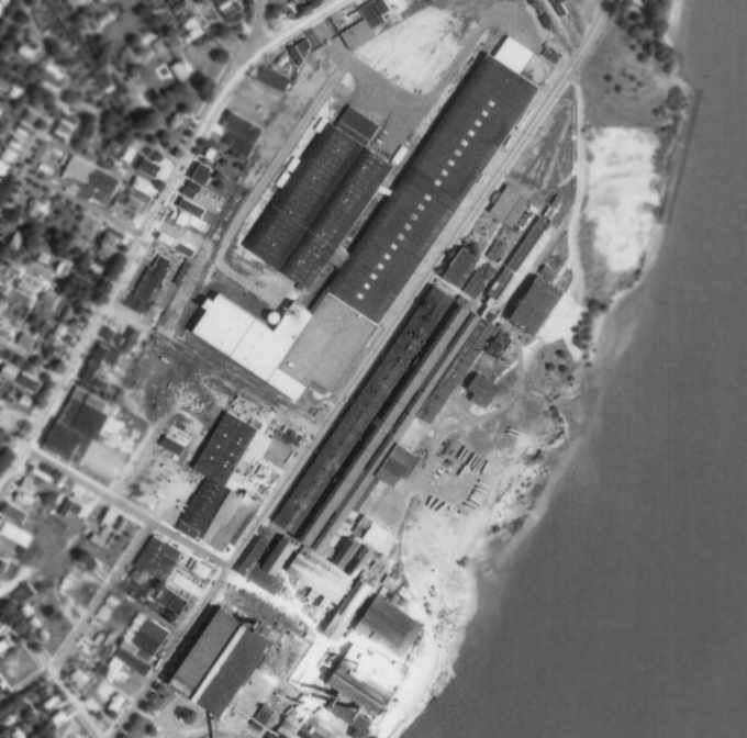
An 8/7/71 aerial view of the former Fleetwings factory & seaplane base.
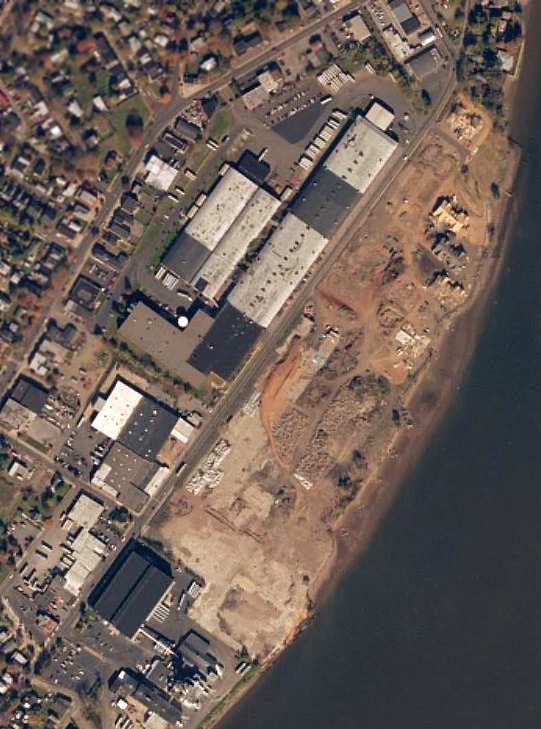
A circa 2001 aerial photo showed the circa 1920s/30s Fleetings factory on the east side of the road had been removed,
along with the hangar & seaplane ramp formerly located at the north end of the complex has been removed.
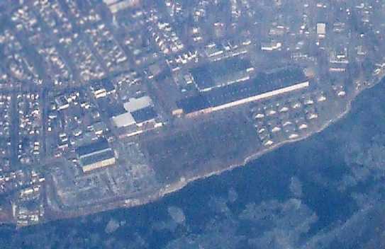
A January 2009 aerial view by Paul Freeman looking north at the Fleetwings factory site.
As of 2022, street maps label the former Fleetwings Factory as B&C Industries.
The Keystone / Fleetwings factory site is located along the Delaware River, southwest of the intersection of Radcliffe Street & Green Lane.
____________________________________________________
Keystone Aircraft Field / Fleetwings Field / Kaiser Field / Kaiser NAS / 3M Airport, Levittown, PA
40.13, -74.85 (Northeast of Philadelphia, PA)
The "Keystone Aircraft Field" & Keystone Seaplane Base, as depicted on the Philly Chamber of Commerce's
1930 "Aviation Map of the Philadelphia Metro District" (courtesy of Tom Beamer).
How many residents of present-day Philadelphia are aware that this obscure little airport (which is no longer is in operation)
was the birthplace of quite a few unusual aircraft?
This airfield was evidently originally built to support the flight testing of aircraft produced by the Keystone Aircraft factory,
located a mile to the south along the Delaware River in Bristol, PA.
The date of construction of this airfield has not been determined.
The earliest reference to an airfield at this location came from Nathan Sturman,
who observed, “The ill-fated transatlantic fliers of the U.S. Navy, Wooster & Davis,
supervised the building of their converted Keystone Pathfinder 'American Legion' at the plant in Bristol [in 1927],
then test-flew it & departed for Langley Field right on the Green Lane Airfield, later to be called 3M [Airport].”
The earliest depiction of the airfield which has been located
was on the Philly Chamber of Commerce's 1930 "Aviation Map of the Philadelphia Metro District" (courtesy of Tom Beamer).
It depicted the "Keystone Aircraft Field" as a north/south field running along the east side of Green Lane.
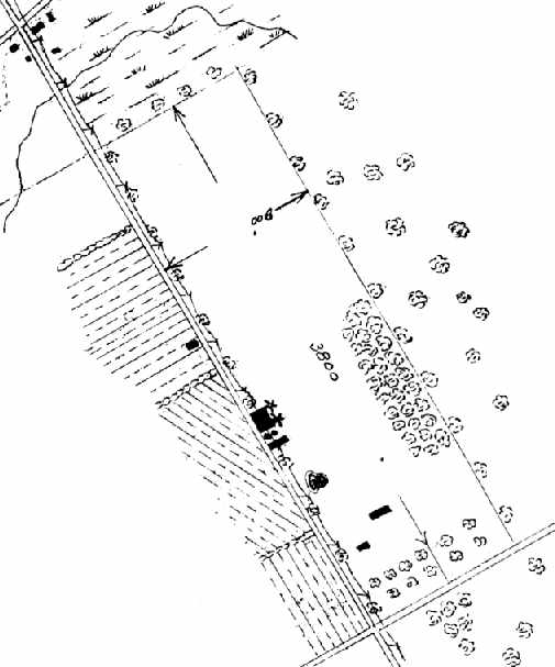
The airfield layout of the "Keystone Aircraft Field",
from the 1930 book "Philadelphia Aeronautical Center of the East"
(courtesy of the George H. Stuebing Collection of the Delaware Valley Historical Aircraft Association).
The directory described the field as consisting of a 45 acre sod field.
The diagram listed the length of the field as 3,800', while the textual description gave a contradictory length - 2,200'.
The field was said to be operated by the Keystone Aircraft Corporation.
A single 80' x 80' metal hangar was depicted along the west side of the field,
and it was said to have "Keystone Welcomes You" & "Bristol, PA" painted on its roof.
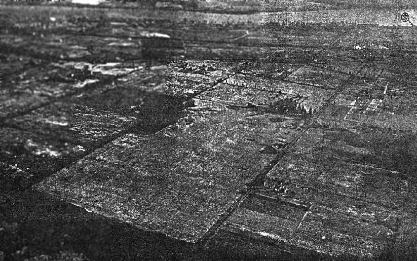
An aerial photo looking southeast at "Keystone Aircraft Corporation Field",
from the 1930 book "Philadelphia Aeronautical Center of the East"
(courtesy of the George H. Stuebing Collection of the Delaware Valley Historical Aircraft Association).
The Keystone seaplane base is also just visible in the background, indicated by the anchor symbol at the top-right.
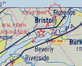
Keystone Field, as depicted on the May 1932 J-18 Washington D. C. Airway Map (courtesy of Chris Kennedy).
Keystone Field was depicted on the August 1932 NY Sectional Chart as an auxiliary airfield symbol, but oddly without any name.
Keystone Aircraft was purchased by the Fleetwings Corporation in 1934.
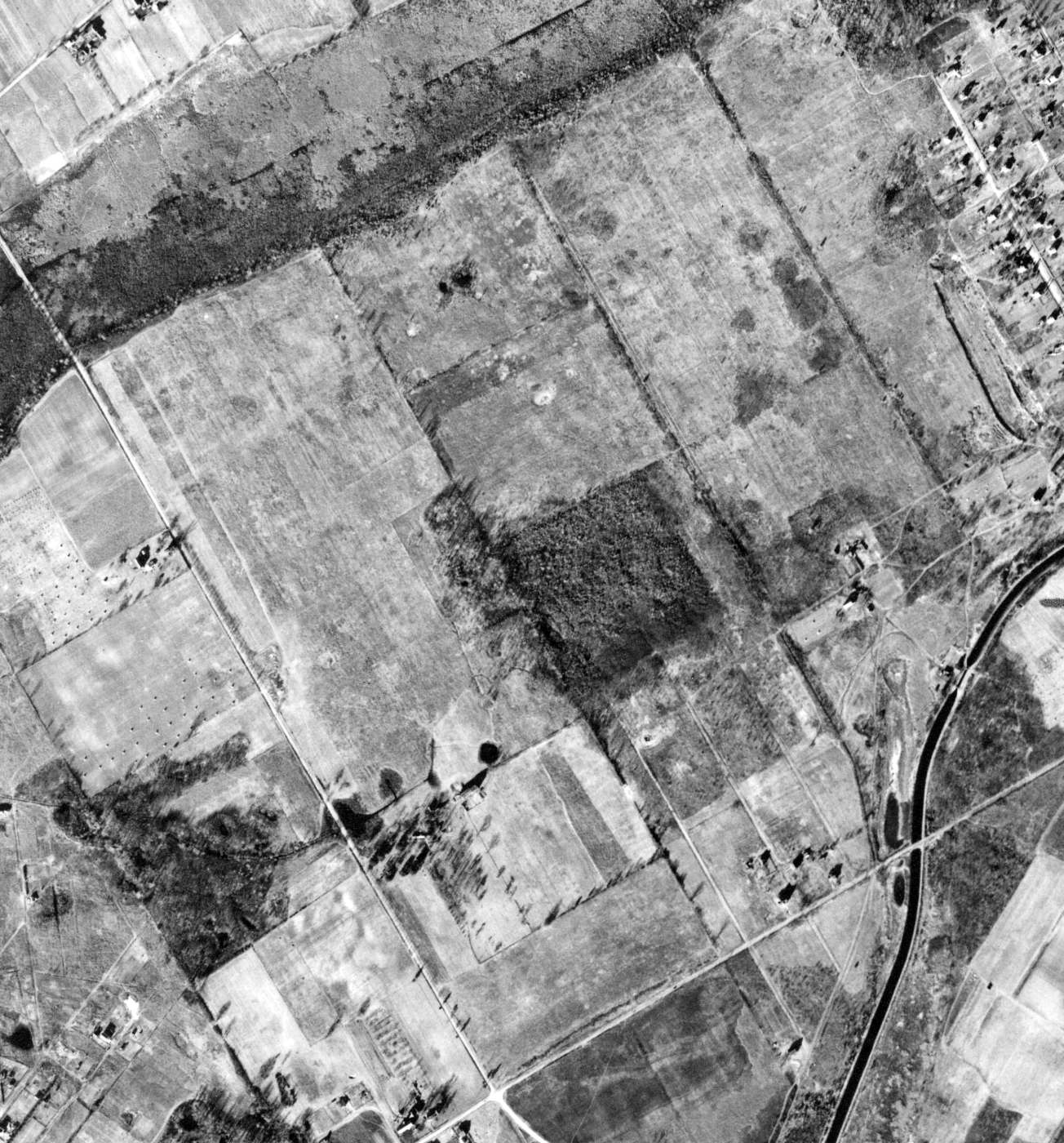
A 12/29/37 aerial view of Keystone Field, showing it as an open grass area, without any significant improvements.
A 1940 aerial view continued to show Keystone Field as an open grass area.
In 1941, Fleetwings built a new factory adjacent to the airfield, along the east side of Green Lane.
During the WW2 period, Fleetwings produced a number of different models of aircraft.
Although Fleetwings continued to operate the former Keystone factory along the river (for component manufacturing),
all Fleetwings aircraft assembly was performed from that point on at the new factory adjacent to the airfield.
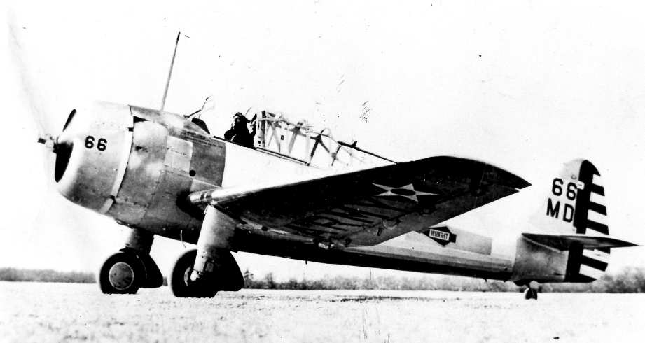
A circa 1941-45 photo of a Fleetwings XBT-12 basic trainer (courtesy of Tom Beamer).
A single prototype of the Fleetwings XBT-12 (39-719) was built.
The XBT-12's claim to fame was that it was the 1st all-stainless steel military airplane.
In 1941, a single example (NX29033) was built of the Fleetwings Model 33 trainer.
It used Alcad construction, and was a smaller version of the stainless steel BT-12.
It also used a 130hp Franklin 6AC horizontally opposed engine, in place of the BT-12's radial.
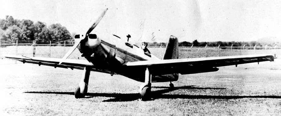
A circa 1941-45 photo of the sole Fleetwings Model 33, a single engine 2-place trainer (courtesy of Tom Beamer).
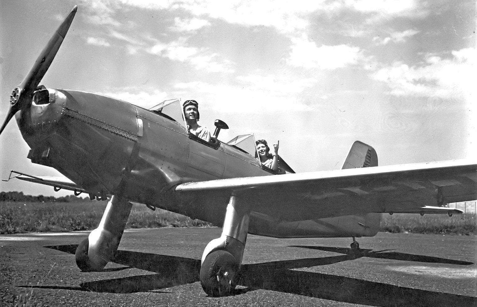
A 1941 photo (courtesy of Bill Engle Jr) of the sole Fleetwings 33 NX29033 at Fleetwings Field.
Bill noted it appeared to be “a staged-looking photo for promotional purposes to flight schools & other commercial users.
Note the landing gear fairings & some minor alterations around the cowling inlets, compared to the earlier configuration.”
The Fleetwings XPQ-12 (Model 36) prototype was built in 1941.
It was an aerial target plane (with manned capability), that bore a strong resemblance to the Ercoupe general aviation aircraft.
A total of 8 YPQ-12's were produced, along with an XPQ-12A prototype, and 30 PQ-12A's, all in 1941.
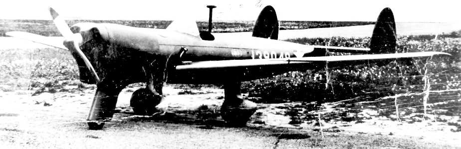
A circa 1941-45 photo of a Fleetwings YPQ-12 Model 36, a single engine plywood target plane,
a "confidential Army project" (courtesy of Tom Beamer).
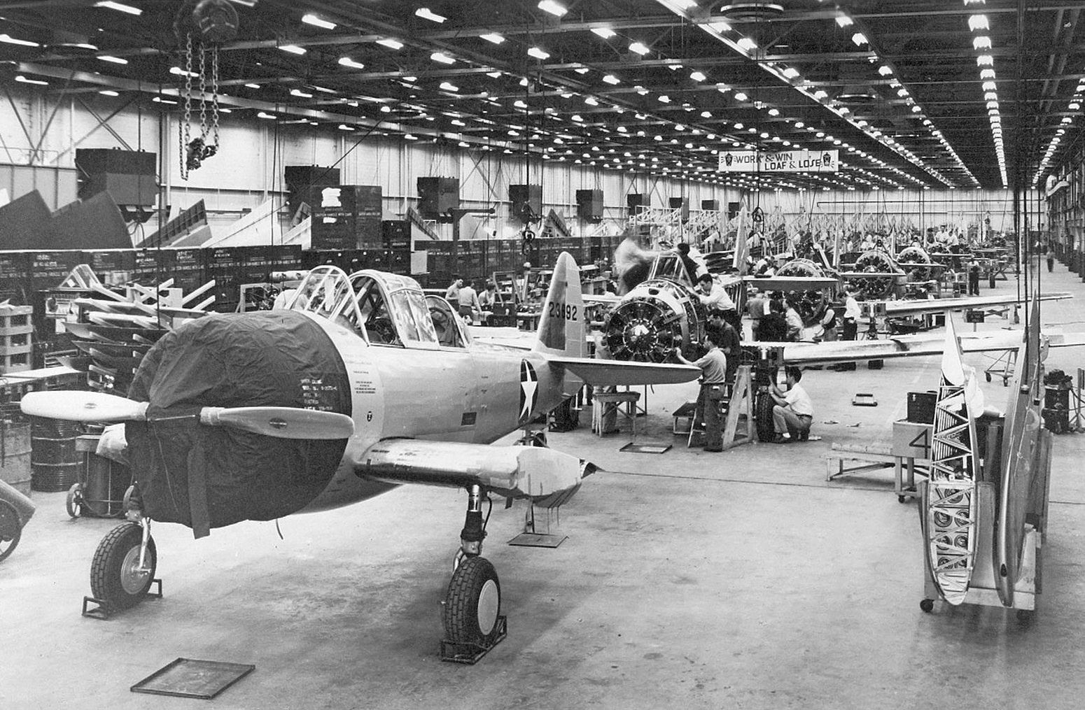
A 1943 photo of Fleetwings BT-12 Sophomore 42-3692 on the Fleetwings production line (courtesy of Bill Engle Jr).
Bill observed the photo showed “ships #9 thru #14 of a 24 ship order with serials 42-3684 to 3707 allocated.
Serials 42-3708 thru 3883, which would have brought the order up to 200, were canceled when the military decided they preferred the Vultee BT-13.
Construction involved the extensive use of stainless steel, including for skin panels.
The fuselage structure was made from carbon steel tube with stainless skin panels attached using 'Shake-proof Fasteners' (probably what is known as quarter-turn fasteners today).
The novelty of the design probably put the military off as being too different for maintenance to cope with.”
Tom Beamer noted, "Interestingly ALL of the world's stainless steel aircraft were built in Philadelphia by Budd & Fleetwings."
According to Lynn Gentzsch, “The 3 concrete runways were installed during WWII by James Morrisey, who became a large, local paver.
Paid for by Uncle Sam. Excellent job, in great shape right until the end.”
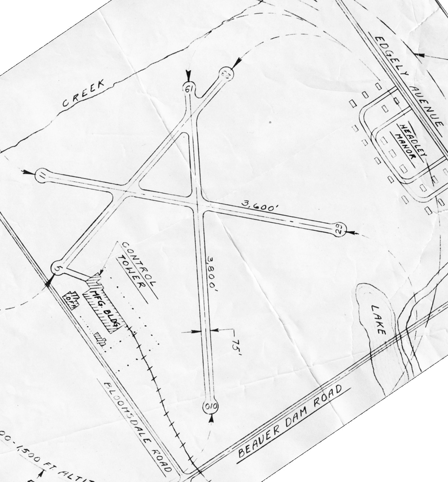
A circa 1942-45 diagram of Fleetwings Field (courtesy of Bill Engle Jr), showing the new configuration of the field with 3 concrete runways.
The Fleetwings XBQ-1 (Model 37) was an early expendable unmanned aerial vehicle, referred to at the time as an "assault drone",
developed by Fleetwings during the Second World War for use by the United States Army Air Forces.
Development of the BQ-1 began on 7/10/42, under a program for the development of "aerial torpedoes" - unmanned aircraft carrying internal bombs - that had been instigated in March of that year.
Fleetwings was contracted to build a single XBQ-1 assault drone, powered by two 250 HP Franklin O-405-7 opposed piston engines, and fitted with a fixed landing gear in tricycle configuration.
The aircraft was optionally-piloted; a single-seat cockpit was installed for ferry & training flights; a fairing would replace the cockpit canopy on operational missions.
The BQ-1 was intended to carry a 2,000 pound warhead over a range of 1,717 miles at 225 MPH; the aircraft would be destroyed in the act of striking the target.
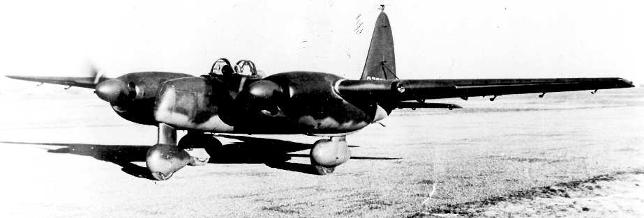
A circa 1943-45 photo of the sole example of the Fleetwings XBQ-1 Model 37, a twin-engine plywood “assault drone” (courtesy of Tom Beamer).
According to Tom Beamer, the Fleetwings Corporation was purchased by Kaiser in 1943,
becoming the "Fleetwings Division of Kaiser Cargo Inc.".
Following trials of the television-based command guidance system using a PQ-12 target drone,
the XBQ-1 flew in May 1944; however, the aircraft crashed on its maiden flight.
Following the loss of the lone prototype BQ-1, the project was canceled
A single improved BQ-2 was to be constructed as well under the same contract
powered by 2 Lycoming XO-435 opposed piston engines, and fitted with a fixed landing gear in tricycle configuration;
the landing gear was jettisonable for better aerodynamics.
The XO-435 engines were dropped from the design of the XBQ-2 before completion, being replaced by two 300 HP Lycoming R-680 radial engines, with the aircraft being redesignated XBQ-2A.
The BQ-2 was optionally-piloted; a single-seat cockpit was installed for ferry & training flights; a fairing would replace the cockpit canopy on operational missions.
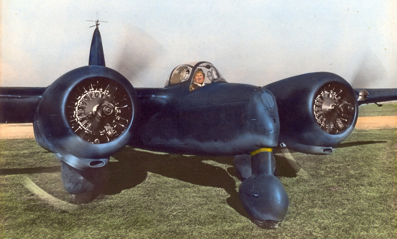
A circa 1943-45 colorized photo of William Engle flying the sole example of the Fleetwings XBQ-2A twin-engine “assault drone” (courtesy of Bill Engle Jr).
After the XBQ-2A flight trials, the design was determined to be too expensive for operational use, and the program was canceled
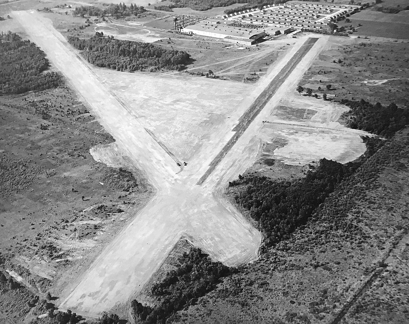
An 8/5/44 Fleetwings aerial view looking southwest at Fleetwings Field (courtesy of Bill Engle Jr), showing 2 newly-paved runways & the Kaiser factory in the background.
Bill observed, “The photo shows the transformation from grass airfield to an airport with paved Runways 19 & 23 shown here under construction, with [Runway] 29 just beginning; all paid for by the U.S. Navy.”
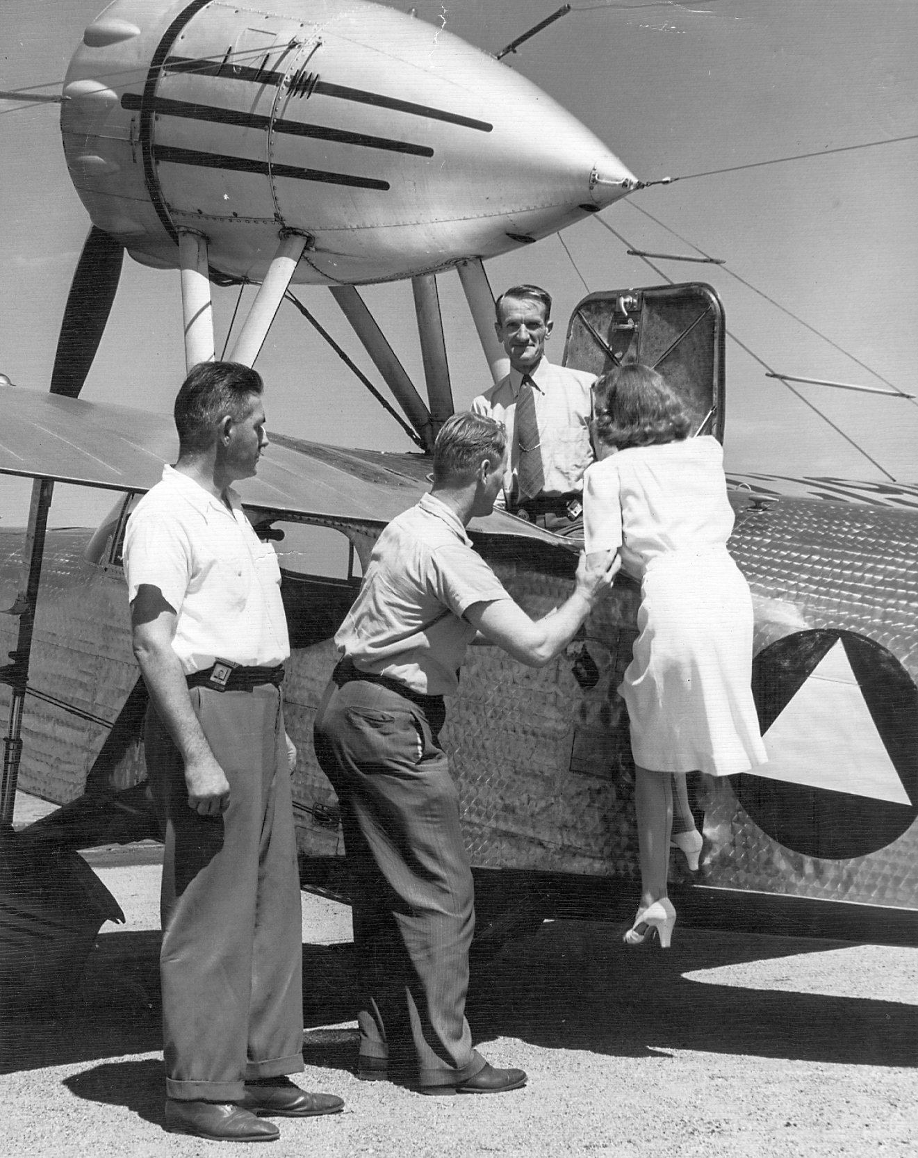
An 8/23/44 photo of pilot William Engle standing in a Fleetwings Seabird (courtesy of Bill Engle Jr), helping to board a passenger.
According to Bill Engle Jr., “A matching 8/23/44 logbook entry reads 'FIRST PASS FLIGHT – KAISER FIELD.'”
Employment at the Kaiser-Fleetwings plant reached its peak in 1944 with over 6,300 employees.
Fleetwings even tried their hand at rotary wing aircraft, building & flying a single example (NX41804) of the Fleetwings Twirleybird.
According to Tom Beamer, "The Fleetwings helicopter was designed by the engineering staff of The Franklin Institute
at Henry J. Kaiser's instigation to provide anti-sub protection from cargo ships.
It was flight tested in 1945.”
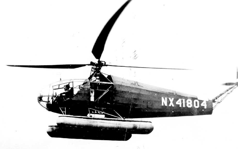
A circa 1945-46 photo of a Fleetwings "Twirleybird" helicopter, pictured with floats (courtesy of Tom Beamer).
According to Tom Beamer, "The Fleetwings Twirleybird project ended shortly after WW2."
Kaiser's last aircraft was the Navy XBK dive bomber, which was initiated in February 1944 with a contract for 2 prototypes.
A mockup inspection without engine was ready in April 1944.
The engine was installed in May 1944 & the completion of the first prototype was scheduled for November 1944.
To speed up later production the U.S. Navy even constructed a new airfield at the Fleetwings plant.
In early 1945 BuAer requested that the plane would be able to carry a torpedo.
The weapon was fitted to a new centreline station & the designation was changed to BTK.
The first XBTK-1 was finally completed in March 1945, making its first flight in May.
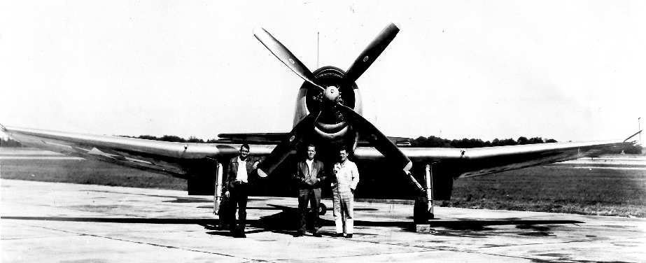
A circa 1945-46 photo of a Kaiser-Fleetwings XBTK-1 (courtesy of Tom Beamer).
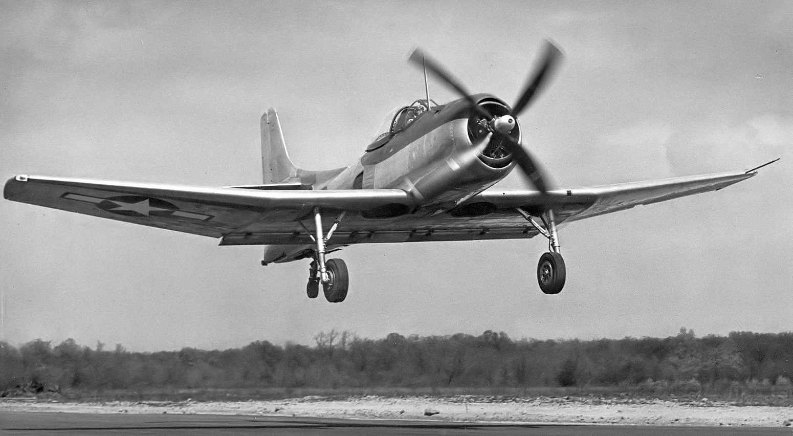
A 4/12/45 photo (courtesy of Bill Engle Jr.) of his father William H. Engle returning to Fleetwings Field in early test flight (possibly its first) of the XBTK-1 44313.
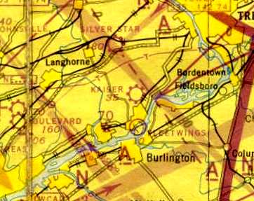
"Kaiser" Airport, as depicted on the 1945 NY Sectional Chart (courtesy of Norman Freed).
After the end of the Second World War the U.S. Navy cut BTK-1 orders to 10 planes.
The prototype was transported back to Fleetwings where redesign began.
The second production aircraft first flew in March 1946 & featured built-in leading edge slots which greatly increased the stall performance of the aircraft.
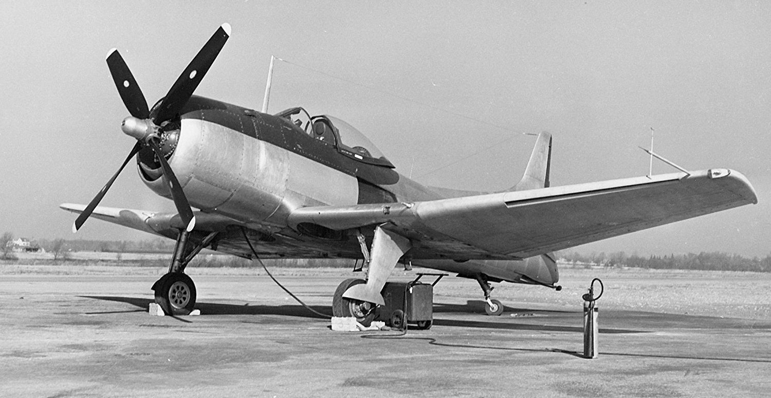
The last photo which has been located of a Kaiser-Fleetwings aircraft at their facility was a 1946 U.S. Navy photo
of the 2nd prototype Kaiser-Fleetwings XBTK-1 (BuNo 44314) at the Kaiser-Fleetwings factory airfield in Bristol.
Note the leading edge slots, an improvement compared to the original prototype.
By early 1946 procurement of new planes was drastically cut down
and the BTK found its role already filled by the Douglas AD Skyraider & Martin AM Mauler.
In May 1946 it was decided to delay corrections of the design & complete 5 airframes already in production.
Although a promising design, the U.S. Navy finally terminated the contract on 9/3/46,
as there was no need for the aircraft anymore, and the 5 prototypes were scrapped.
Thus came to an end this unheralded aircraft manufacturer.
Employment at the Kaiser-Fleetwings plant dropped precipitously after the end of World War II.
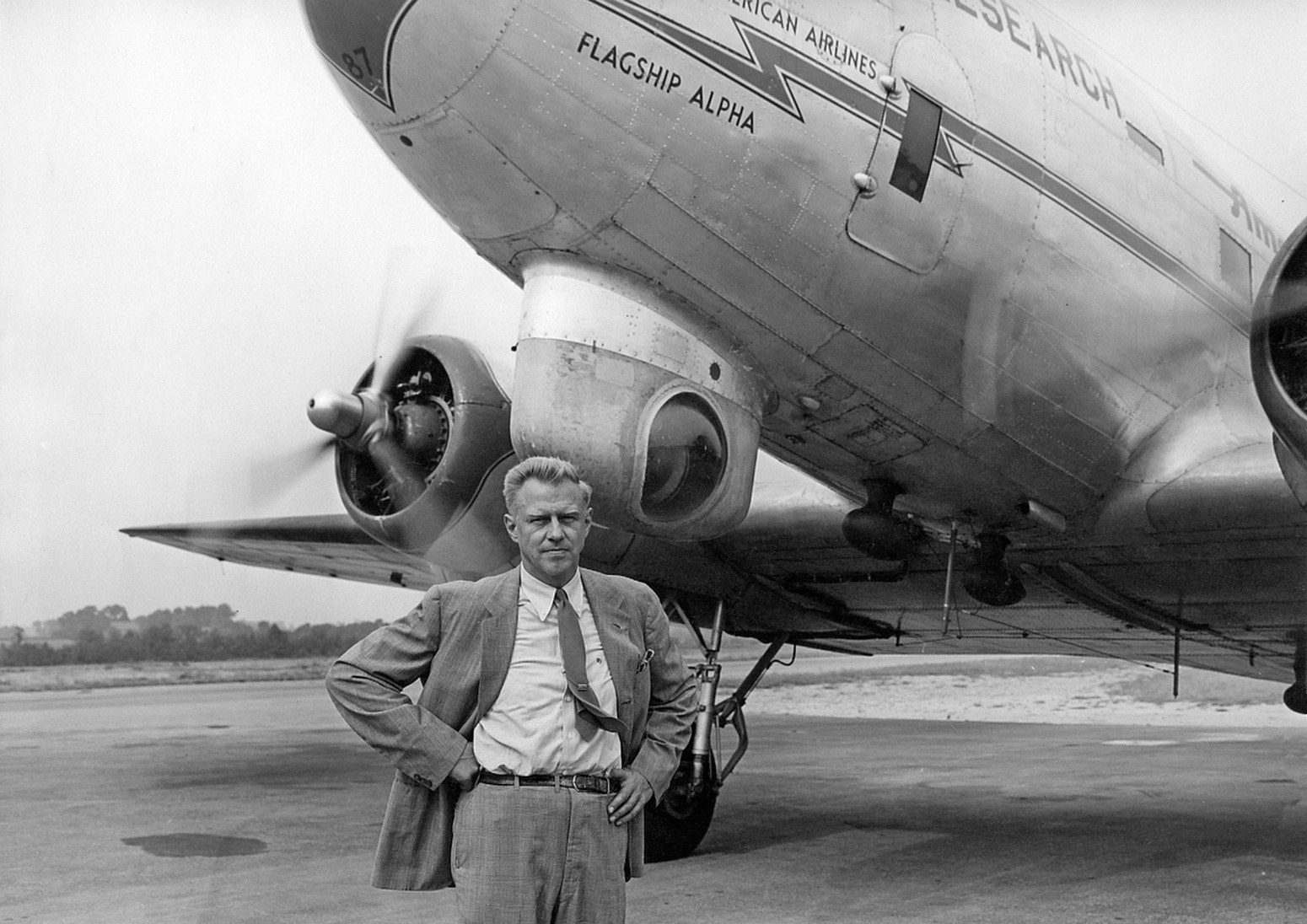
A 9/20/46 photo (courtesy of Bill Engle Jr.) of Fleetwings Chief Engineer R.W. Ayer in front of American Airlines Douglas DC-3 NX88787 C/n 19639 “Flagship Alpha” at Fleetwings Field.
The cupola under the nose had been added for radar research.
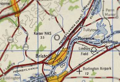
The field was labeled as “Kaiser NAS” on the 1947 USGS topo map,
which certainly is a strange designation, as this field never operated as a Naval Air Station.
The airfield was still depicted as "Kaiser" on the 1949 New York Sectional Chart (according to Chris Kennedy).
The 3M Company purchased the airfield & the newest Green Lane factory in the 1950s, and thus the field was renamed 3M Airport.
According to Lynn Gentzsch, “When 3M bought the factory, they closed the one runway that led to the factory.
If a plane had gone off the end into that factory, there would have been a very large boom!
I remember, when landing, seeing all the X's on that runway, the turnpike bridge & the red balls on the high-tension wires.”
In the 1950s, 3M leased the airport to Engle Air Service.
According to Tom Beamer, Engle had been the head of flight test for the Fleetwings company.
A 1953 aerial view depicted 3M Airport as having 3 paved runways, with a total of 17 light aircraft parked around the south end of Runway 1.
The former Fleetwings Aircraft factory was visible on the southwest side, but with no aircraft around it.
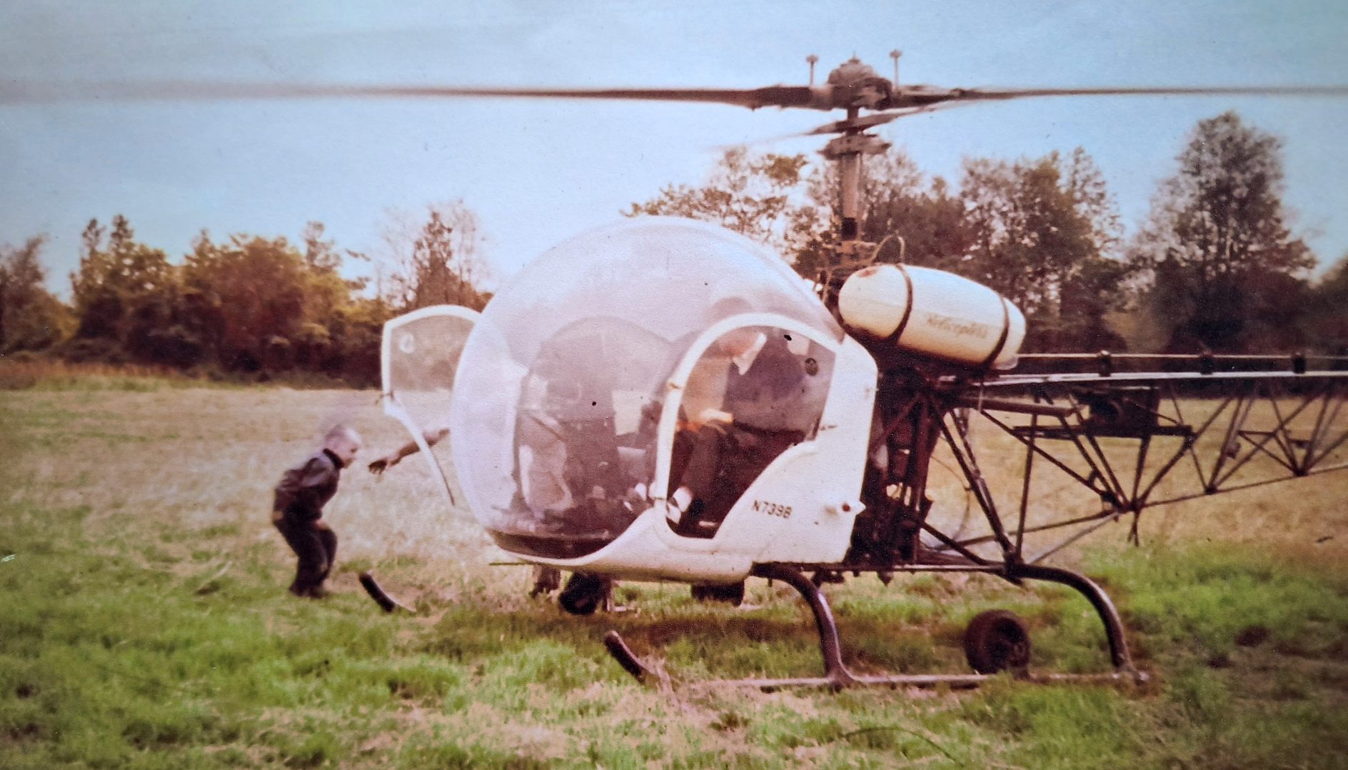
A 1957-58 photo of a Bell 57 helicopter at 3M Airport (courtesy of David Wallace).
David recalled, “The Bell helicopter was rented by my dad Bill Wallace. He had rented it from the commercial helicopter service to do a repair job on a Caterpillar tractor in NJ that was inaccessible by any other means.
That is me ducking under the blades. My little brother is inside. We were secured by one seat belt.”
The 1957 PA Aeronautical Chart (courtesy of Mike Keefe)
described Three-M Airport as having 2 bituminous runways: a 3,800' north/south strip & a 3,600' east/west strip.
The operator was listed as Engle Flying Service, and the manager was listed as Harold Hayden.
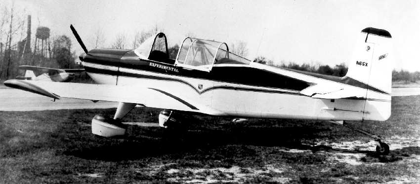
A circa 1957-58 photo of a HPK SP-1 at 3M Airport (courtesy of Tom Beamer).
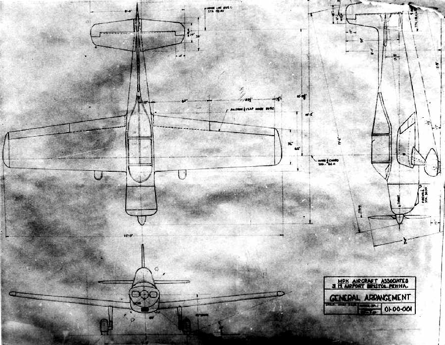
A circa 1957-58 plan of the HPK SP-1, built at 3M Airport (courtesy of Tom Beamer).
According to Tom Beamer, HPK Aircraft built the SP-1 ("Some Pisser-1")
at 3M Airport with an eye to the light counter-insurgency market.
HPK Aircraft Associates consisted of Harold Hayden, Art Payne, and Robert Kinney of the Engle Flying Service.
A single example of the SP-1 (aka Engle HPK) was built in 1957.
The SP-1 was a single-seater, powered by a 115hp Lycoming O-235C,
and it won a reward for outstanding workmanship in 1958.
Unfortunately, flying operations at 3M became more difficult when the nearby PA Turnpike was completed in the 1950s
as the raised bridge approach made take off & landing hazardous on the main runway.
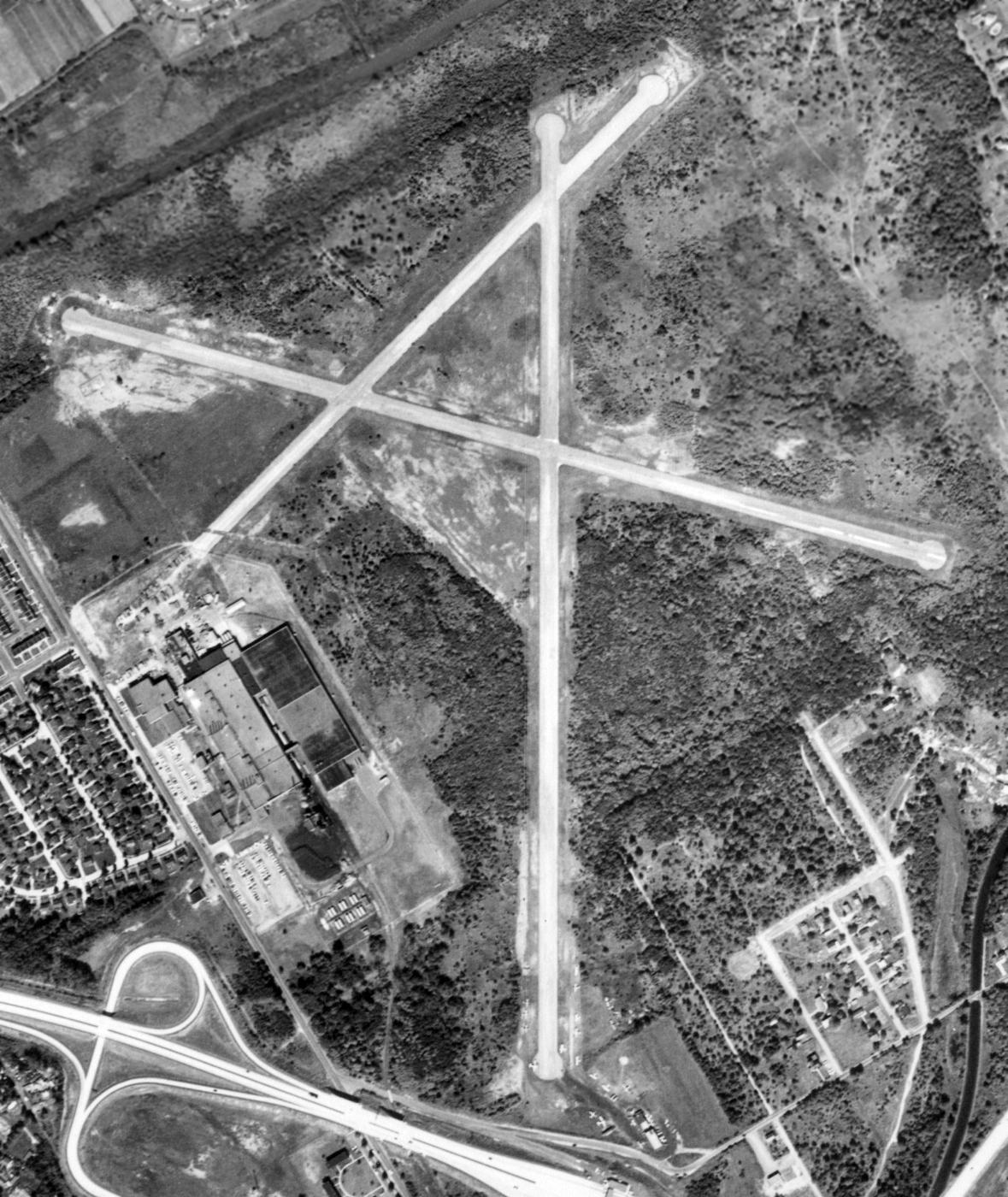
A 9/29/58 USGS aerial view depicted 3M Airport as having 3 paved runways, with a total of 17 light aircraft parked around the south end of Runway 1.
The former Fleetwings Aircraft factory was visible on the southwest side.
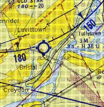
The 1959 Philadelphia Local Aeronautical Chart (courtesy of Chris Kennedy) described 3M Airport as having a 3,800' hard-surface runway.
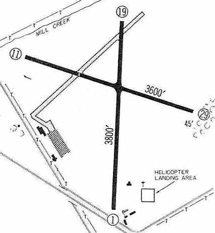
The 1960 Jeppesen Airway Manual (courtesy of Chris Kennedy) depicted 3M Airport as having 2 paved runways (3,800' Runway 1/19 & 3,600' Runway 11/29),
as well as an abandoned northeast/southwest runway.
A helicopter landing area was located on the southeast side of the field, and a ramp with 3 buildings was located on the west side.
The Kaiser-Fleetwings Company still reportedly existed as late as 1960,
when it manufactured the launch canister for the Echo 1 balloon satellite at its Bristol factory.
The plant was closed in 1962, ending this interesting chapter of aviation manufacturing.
David Wallace recalled thas his father Bill based his Cessna 175 Skylark at 3M Airport:
“We were active at 3M while the DC-3 was still flying on occasion. The home-built Denight Special racing plane was tied down there.”
Bill Stewart recalled of 3M Airport, “I was based there from 1962-69, when it was managed by Engle Flying Service - Harold Hayden & Don Carlson.
Reno Benner was chief mechanic & his son-in-law Dave Levin & Jim McGinley were instructors.”
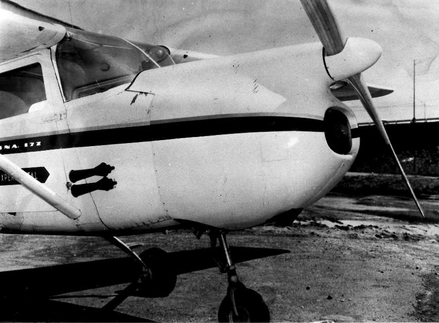
A circa mid-1963 photo of a Cessna 172 at 3M Airport modified with a Unitwin twin-engine installation (courtesy of Tom Beamer).
According to Bill Stewart, “The strange modification of the Cessna 172 was owned & funded by Unitwin Corp,
a group formed by Dick Young - former WACO & Fleet Canada chief engineer.
I ferried the unmodified Cessna, N7257A, from Garden Spot (Lancaster PA) to Princeton Airport for Dick.
The 172 hadn't been flown for a year or so & the only working instrument was the oil pressure gage.
The purpose of the program was to evaluate one approach to providing multi-engine centerline thrust.
The key element was Dick's Integrating Gearbox, which took 2 engine inputs into a single output (propeller).
With both engines carrying the load, output & input RPM was the same.
As power from one engine decreased and the RPM of the input shafts began to differ,
the gear reduction (an ingenious planetary setup) came into play & the output RPM dropped to permit the remaining engine to maintain RPM.
Loss of an engine required no pilot action other than full throttle on the remaining engine.
The fixed pitch prop (low cost) simply slowed to not overload the survivor.”
Bill continued, “Kinney Tutner Associates (General Techniques Inc) based at Mercer County Airport was responsible for the design
and I, a young aero engineer, then working for a Princeton aerospace think-tank, moonlighted to do the nuts & bolts design.
It was intended to power the ship with 2 Continental C-85 engines, turning a Sensenich 108-inch reverse-rotation wooden propeller.
I offset the raised thrust line 4 inches to the right to compensate for the increased propeller moments.
The gearbox was late in coming so the first flights were conducted with a single C-85,
yet the slow turning 9-foot prop provided excellent takeoff & climb performance.
Dick flew the first flights by himself, then along with me and finally, I got some flight time.
The customer pulled the plug despite the excellent preliminary results.
Customer was rumored to have been Cessna, and at that time they had decided to produce the centerline thrust 336.
The 172 was returned to stock configuration & sold.”
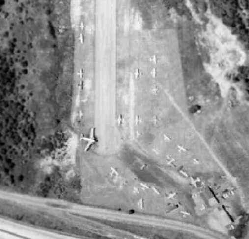
A closeup from a 1963 aerial view, showing 3M Airport at perhaps its zenith of popularity,
with over 29 aircraft parked around the south end of Runway 1, including a Douglas DC-3.
3M Airport was described on the Aerodromes table on the 1965 NY Sectional Chart (courtesy of John Voss)
as having 3 bituminous runways, with the longest being 3,865'.
However, the remarks included "NE/SW runway closed."
Lynn Gentzsch recalled, “I flew out of 3M Airport from 1965-66 & knew Harold Hayden & his partner. A real pair!
One had been a barnstormer & was my 1st instructor.
He demonstrated some of his skills to me which I remember vividly!
They had a Douglas DC-3 that they rented out & in the hangar they has a complete, but disassembled Jenny!”
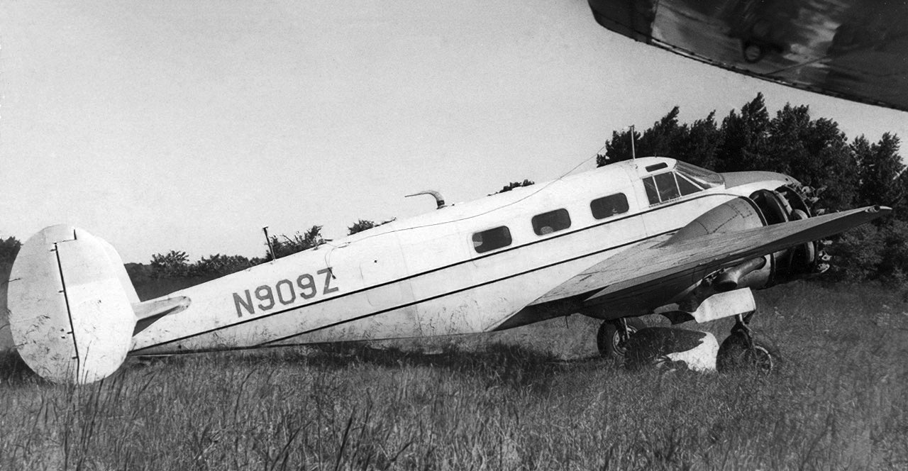
A 9/25/67 photo by Neil Aird of Beech C18S, N909Z C/n 6046, at Kaiser Field / 3M Airport.
After Engle Flying Service moved out of 3M Airport,
Hortman Aviation relocated from Morrisville Airport (which had closed) to 3M Airport at some point between 1969-70 (according to Nathan Sturman).
3M Airport was very busy due to the nearby construction of the Levittown housing development,
and had Cessna, Piper and Grumman dealerships with an FBO.
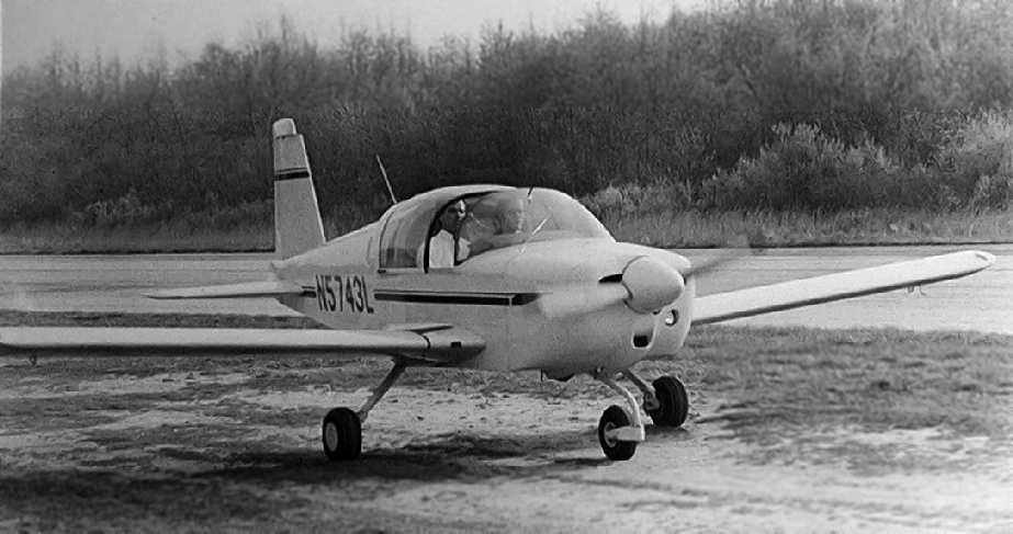
Instructor Tom Schafer taxies out with student pilot Paul Taylor
in an American Aviation Yankee at 3M Airport in 1970 (photo courtesy of Nathan Sturman).
Nathan Sturman took flying lessons at 3M Airport in 1970. "Hortman Aviation were the dealers for the new line
of small aircraft being made in Cleveland [the Grumman American Yankee],
and I spoke to Mrs Hortman on the phone & scheduled my 1st lesson in the Yankee with Bill Barenberg.
It was Earth Day, 1970 as I remember, high overcast.
Taking lessons from Bill (and as my log reveals Ken Langford & Norm Hortman, probably a progress check),
I soled shortly afterward on 5/10/70 in the red Yankee N5711L on Runway 29 at 3M.
Bill went around twice with me & told me to make the next landing to a full stop.
We taxiied back & Bill asked me for my student pilot's license which he wrote something on the back of.
I still wasn't wise as to what was happening."
Nathan continued, "Then he crushed out his cigarette in the ashtray, stood up through the open canopy & got out onto the wing.
'Take it around the pattern once & don't [screw] up,' he said, looking down at a terrified Nate Sturman.
'If I like what I see I'll let you do it again.'
Heart pounding, happy beyond words I taxied back to the bubble, did a careful runup & pre-takeoff check & I was off!
'Yankee 11Lima departing Runway 29er at 3M' I proudly announced on the unicom.
I was surprised that the plane performed so much better with only my weight as I remember.
Nice landings, 3 in a row, each time checking back with Bill at the intersection,
and no dreaded 'porpoise'- it was before the larger main tires were fitted.
They took a bit of my shirt tail as I remember, don't remember where it is now."
Ken Lankford recalled, “I was an instructor at 3M in 1970, Lots of stories came out of that time working for Yvette & Norm!
One cloudy day, Mike Shea & I came across Norm Hortman's Very Pistol from his early days of transatlantic flying.
We shot it off & it lit up all of Levittown! I think Mike has a picture that he took before the fire engines from 6 towns arrived.”
A 1970 aerial view showed that a hangar had been added at some point between 1963-70 along the southeastern end of Runway 1.
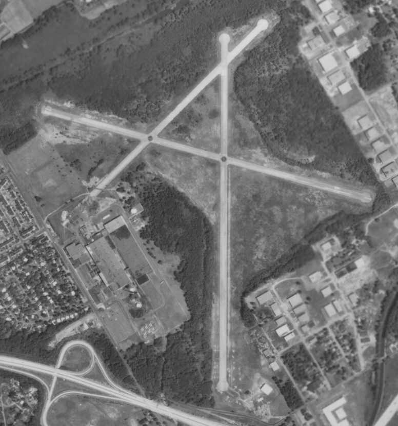
An 8/7/71 aerial view of 3M Airport, showing the former Fleetwings Aircraft factory on the southwest side.
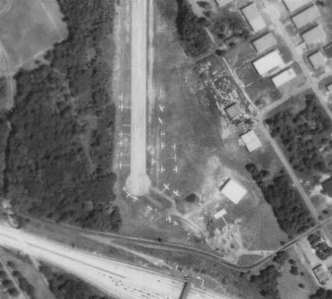
A closeup from the 8/7/71 aerial view, showing over 24 light aircraft clustered around the southern end of 3M's Runway 1.
According to Nathan Sturman, Hortman Aviation owner Norm Hortman
"was killed in an accident in March 1974 while ferrying a used aircraft (CO poisoning) back to 3M."
The February 1975 Philadelphia Terminal Aeronautical Chart (courtesy of Mitchell Hymowitz)
depicted 3-M Airport as having a 3 paved runways, with the longest being 3,700'.
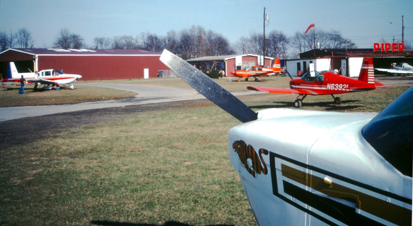
A July/August 1976 photo by Jack Kenton of several Grumman Tigers at 3M Airport.
Jack recalled, “I was using a Tiger to get a single-engine Airline Transport Pilot [rating] at this airport.”
Nathan Sturman passed along the following story about a crash at 3M Airport.
"On the afternoon of Friday, 6/16/1978, I was on the job as a flight instructor for Hortman Aviation at 3M.
A new student, Jane Howe, had just been brought in by her grandfather, got an orientation ride.
She was to take lessons with me to 1st solo & beyond.
But on parting that 1st day she warned me that there was something I ought to know,
that she had been a jinx all her life, and that weird things might happen around there now that she had appeared."
Nathan continued, "Well, as she, her gramps and her 2 kids left,
in strode Mr. Seymour Hundley, a very popular & enthusiastic middle-aged student pilot
who had just soloed a couple of weeks earlier.
Being in his late forties or early fifties he was not the most apt student (heavy handed but otherwise OK)
but with time & patient instruction he learned how to handle the PA-128-150 Warrior
and soloed eventually with about 24 hours' experience.
He actually got pretty good at landings.
Well, Seymour came in that afternoon to practice solo flying,
and even though his supervised soles were done I gave him the customary Hortman 'wind check' (once around the pattern)
and got out way down Runway 11/29 at the intersection with the closed runway,
telling him to pick me up there after his 1st landing. It was overcast as I recall."
Nathan continued, "He took off normally from Runway 29 & flew a nice pattern
but another aircraft entered downwind in front of him & he extended his downwind leg considerably,
barely visible over the turnpike bridge & then turned onto a base leg, too low & far out...
he seemed to be descending in stairs, with irregular bursts of power which I could then hear faintly,
like a WWI plane with a rotary engine crouping,
or a diesel model engine in lean undercompression toward the end of its run.
The landing light was on as he turned final directly from the base turn, the procedure for loss of power.
A flight instructor's nightmare: the power lines before the runway threshold were in front of the light!
He was really low, no flaps as he was told on emergency approaches,
sinking & dragging with alternating bursts of power & simultaneously out of altitude, airspeed & ideas
when his undercarriage snapped the power lines & the plane tumbled over
and plunged to earth with a loud 'crump' behind the trees.
Bright sparks shot from the snapped lines & soon a loud wailing civil defense siren went off in the distance.
I was about 800 meters away but began running as fast as my size 11 Florsheims would carry me,
but making no progress, like in a dream where you run in bed but can't get anywhere."
Nathan continued, "Beyond the trees at the runway's end I could hear voices shouting 'jump!', 'jump!',
and a small plume of bluish white smoke was rising, with a sputtering & buzzing as from arc welding.
Then as I reached perhaps the intersection with Runway 1
a fireball rose above the trees followed by a column of black smoke & a sharp explosion,
followed by another & a small mushroom cloud.
When I reached the bubble at the runway's end I could feel the intense heat
as I found an opening in the barbed wire & began clawing my way through the briar patch & dense wood.
The plane was blazing away & the Lower Bucks Fire & Rescue people & vehicles were there already,
as were the nearby factory personnel & some fellows from the airport who beat me there by driving around in the Jeep."
Nathan continued, "Well, miraculously, Seymour was fine, but the plane had been flattened & was blazing furiously.
A wire had arced onto the left wing tank & burnt a hole in it, setting off the explosion,
and Seymour heeded the advice to jump, not step, off of the wing.
Nearly tragically, he jumped back onto the plane & disappeared into the blazing cabin FOR HIS STUDENT PILOT KIT.
All's well that end's well, though.
They took Seymour to Lower Bucks County hospital for observation
and he had a minor injury to his shoulder, that was all, probably saved by that 3-point harness & his quick action."
Nathan continued, "The Bucks County Courier Times carried an article on the crash the next day.
As usual with aviation stories they had it all wrong, and erroneously put ME in the plane with Seymour
saying that we hit wires while landing & both escaped a fiery end, etc.
My mother was working at Gimbel's Cheltenham store & her coworkers showed her this story,
and my wife heard that account too & probably always had doubts about what happened.
A lot of people heard the reports & my name on the evening news, KYW etc.,
and the crash made at least one network that evening."
Nathan continued, "The FAA cleared Seymour & ruled that it had been a fuel starvation caused by a probable foreign object.
The maintenance shop objected to this, as the plane had just come out of 100 hour inspection,
and they demonstrated how a pilot could close the mixture instead of the throttle,
then pump the throttle & feed gas with the accelerator pump, thus getting that cycle of surging & windmilling.
The FAA, however, stuck by their judgment."
Nathan continued, "Hundley returned. He insisted that he had closed the mixture as the plane went in, not before.
I was the 1st to fly with him after his return a couple of weeks later.
He was really nervous, with a death grip on the yoke,
and I was starting to worry because he was a really big man with what seemed the biggest hands in the western world.
He smoothly reduced power, slowed down a bit & lowered a notch of flap.
Just then, ahead of us & below, a car exploded in a traffic accident on the Turnpike Bridge in the Delaware
and a black plume of smoke went boiling upwards toward us. Talk about bad timing.
Seymour just turned base in quite a funk I am sure, flew a perfect base & final,
made the best landing of his career to date & taxied back to the pumps.
He had a few more rides before giving up on his license with us I recall.
Years later I heard that he was flying an old Cessna 150 of his own somewhere in New Jersey."
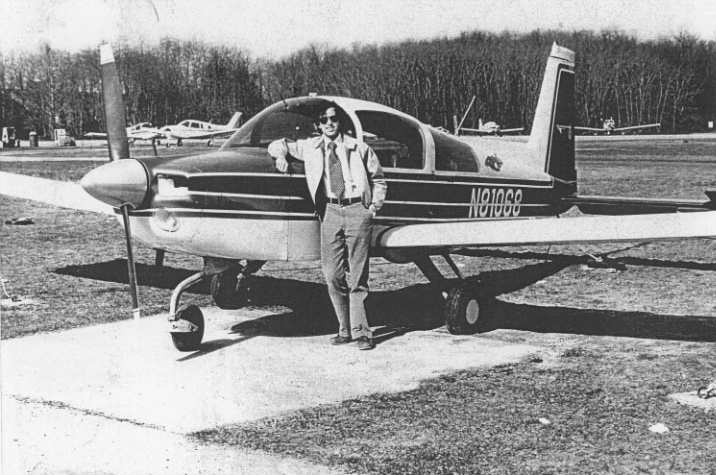
Recalling the flight from the same airfield in 1927 of the Keystone Pathfinder 'American Legion',
Nathan Sturman observed, “In all of the perhaps thousands of takeoffs & landings
I did on that strip I never dreamt of whose steps I was literally following in.
Time joins us all together in funny ways with those who went before.”
Joe Koch recalled, “I got my ticket at 3M in 1978. A great place & I did fly with Nate Sturman 2 times.
I used to take a Grumman & go to Van Sant. One day I was going flying & Herb [Hortman] asked where I was going & I told him VanSant.
Well he told me his mom did not want renters going into there. I told him I had been doing it for a year & he said OK, no problem.”
Joe confirmed that 3M was a dealer for the Grumman aircraft line.
But Joe elaborated, “The instructors did not like them. They called them garbage cans. I really liked them.
A J3 taught you rudder & how to fly & a Grumman was the same only a lot faster!!!”
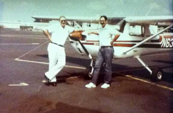
The last photo which has been located showing 3M as an active airport was a 1979 photo of Joe Koch & his father in front of a C150 that was owned by a friend of his dad.
Walt Stepek recalled, “When I finally decided to start taking lessons in 1980 I did have an introductory ride in a Grumman AA-1C at 3M, and enjoyed the experience.
It was truly sad to see 3M Airport close, but happily enough, the Hortmans were able to locate to Philly Northeast.”
According to K. Doolin, the 3M Company closed the airport around 1980 due to insurance concerns,
and Hortmann Aviation moved to the Northeast Philadelphia Airport.
Paul Campbell recalled, “After Hortman moved to Northeast Philadelphia Airport people started using the runway to drag race.
So channels were cut across the asphalt to discourage that. Later on a trucking school was using it to train students.”
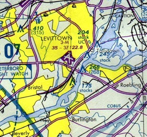
In spite of other indications that it had closed several years earlier,
3M Airport was still depicted as an active airfield on the March 1981 Philly Terminal Area Chart,
and depicted as having 3 paved runways, with the longest being 3,700'.
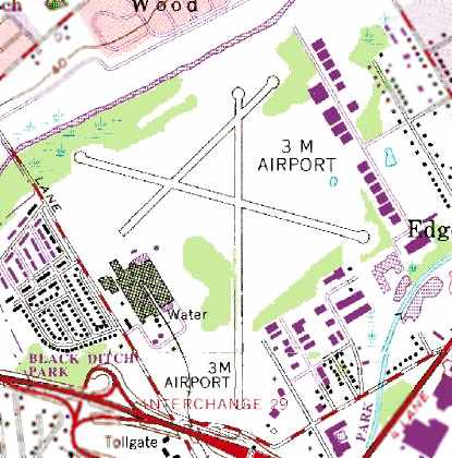
The 1981 USGS topo map still depicted the 3 runways of 3M Airport, as well as multiple buildings around its periphery.
3M Airport was depicted as a closed airport on the March 1987 Philadelphia Terminal Aeronautical Chart (courtesy of Kevin O'Reilly).
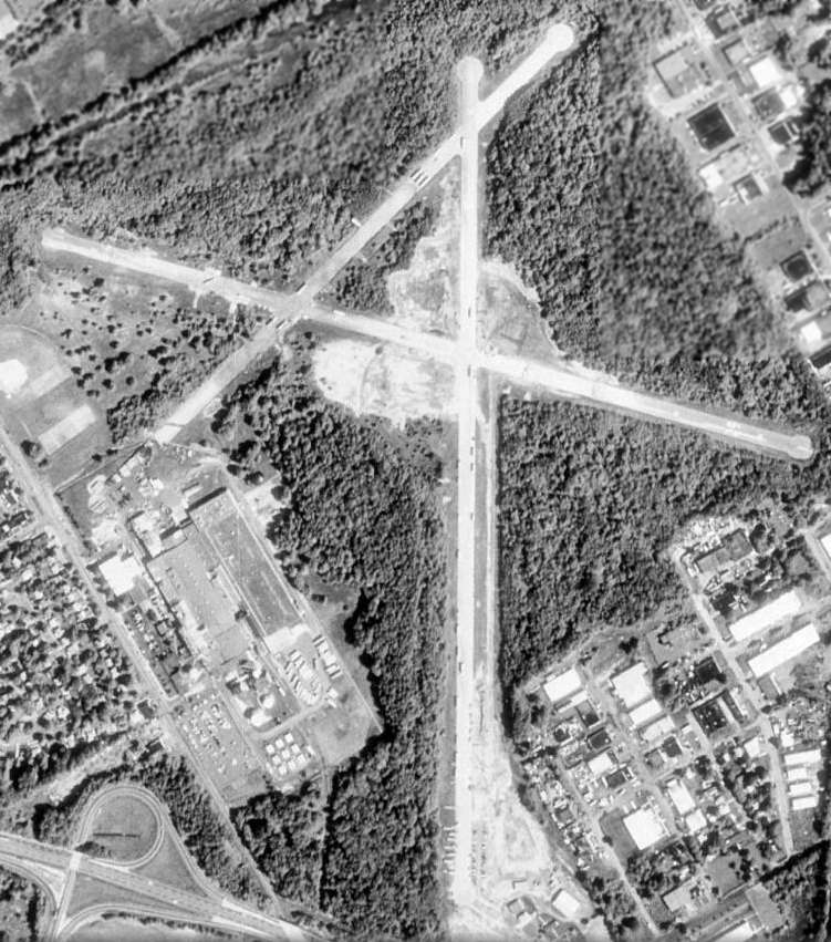
In a 4/25/92 USGS aerial photo, all 3 runways at 3M Airport still remained largely intact,
along with the former Hortman hangar on the southeast side of Runway 1,
and the Kaiser-Fleetwings aircraft factory along the west side of the field.
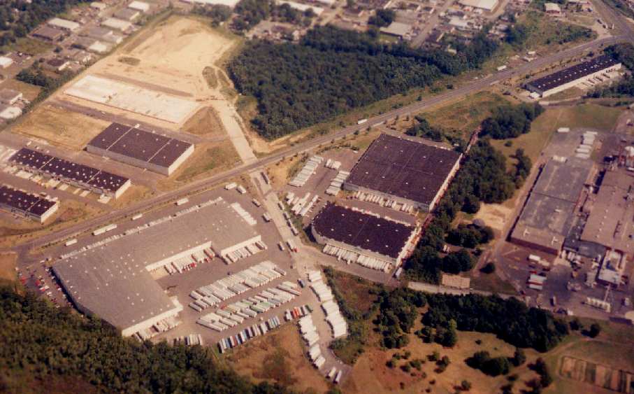
By the time of this 1998 aerial photo by Philip Kineyko, the former 3M Airport had been reused as an industrial park.
The former northeast/southwest runway had been completely built over,
although the 2 larger runways were still recognizable (the longest is 4,000').
The remains of the runways have been reused as roads for the surrounding businesses.
The former Kaiser-Fleetwings aircraft factory was also still standing, visible in the right side of the photo.
A 1999 aerial view showed that the hangar remained standing on the southeast side of Runway 1.
A 2002 aerial view showed that the Hortman hangar on the southeastern end of Runway 1
had been removed at some point between 1999-2002.
According to Tom Sofield, “In fall 2005 director Night Shyamalan filmed his film 'Lady in the Water' at the old 3M Airport.
There was a 5-story shell of an apartment building built with a real pool that was used for the filming of the movie.”
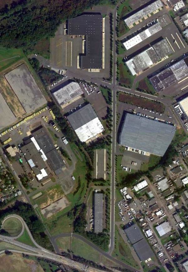
A 10/7/11 aerial photo, showed that 2 of the runways from 3M Airport had been reused as streets.
The former Kaiser-Fleetwings aircraft factory along the west side of the field also remained intact.
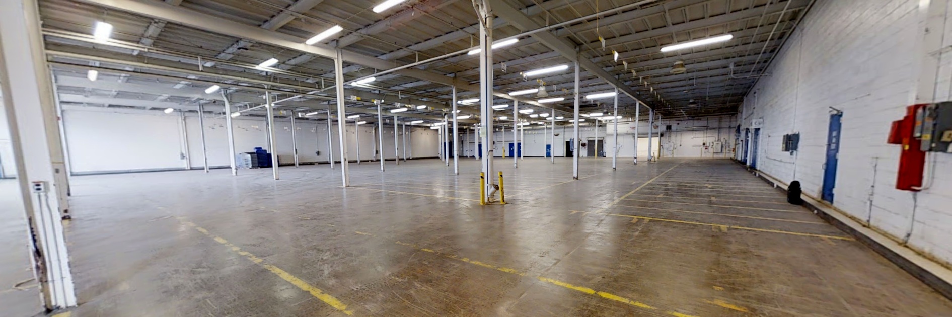
A July 2021 photo looking west inside the former Kaiser-Fleetwings aircraft factory on the west side of the former 3M Airport.
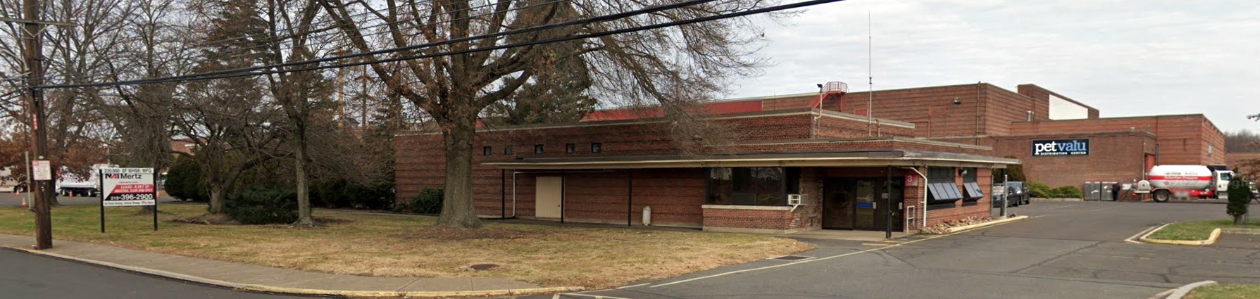
A December 2021 photo looking north at the former Kaiser-Fleetwings aircraft factory on the west side of the former 3M Airport.
The site of 3M Airport is located north of the intersection of the Pennsylvania Turnpike & Route 13.
A clue to the former role of the property may be found in the names of the streets
of a small residential development adjacent to the west side of the former airfield,
which include "Fleetwing [sic] Drive", "Mitchell Road", "Airacobra Street", and "Liberator Street".
____________________________________________________
Or if you prefer to contact me directly concerning a contribution (for a mailing address to send a check),
please contact me at: paulandterryfreeman@gmail.com
If you enjoy this web site, please support it with a financial contribution.
____________________________________________________
This site covers airfields in all 50 states.
