Abandoned & Little-Known Airfields:
Pennsylvania: Erie area
© 2002, © 2026 by Paul Freeman. Revised 7/3/26.
This site covers airfields in all 50 states: Click here for the site's main menu.
____________________________________________________
Please consider a financial contribution to support the continued growth & operation of this site.
Brokenstraw Field (revised 7/3/26) - Carlson Airport (revised 2/5/26) - Culbertson Hills Airport / Edinboro Airport (revised 2/5/26)
(Original) Erie County Airport (revised 1/23/24) - (New) Erie County Airport (revised 2/5/26)
Harri-Emery Field (revised 5/24/19) - Kearsarge Airport (added 9/21/12) - Warren Airport (revised 2/5/26)
____________________________________________________
Brokenstraw Field (original location), Youngsville, PA
41.842, -79.353 (Northeast of Pittsburgh, PA)
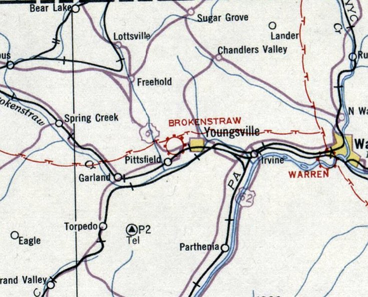
Brokenstraw Field, as depicted on the December 1932 Cleveland Sectional Chart.
Stephen Castano reported, “The original Brokenstraw Airport, between Youngsville & Pittsfield north of Route 6, was owned & operated by Frank Rensma.”
Candy Sargent reported, “Frank Rensma & his brother started & owned the Brokenstraw Airport.”
The date of construction of Brokenstraw Field has not been determined.
The earliest depiction which has been located of Brokenstraw Field was on the December 1932 Cleveland Sectional Chart.
It depicted Brokenstraw as a commercial/municipal airport.
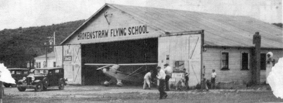
The earliest photo which has been located of Brokenstraw Field was a circa 1930s photo of a Piper Cub inside the Brokenstraw Flying School hangar (courtesy of Stephen Castano).

A circa 1930s photo of a path dug through the snow to a Piper Cub inside the Brokenstraw Flying School hangar (courtesy of Stephen Castano).
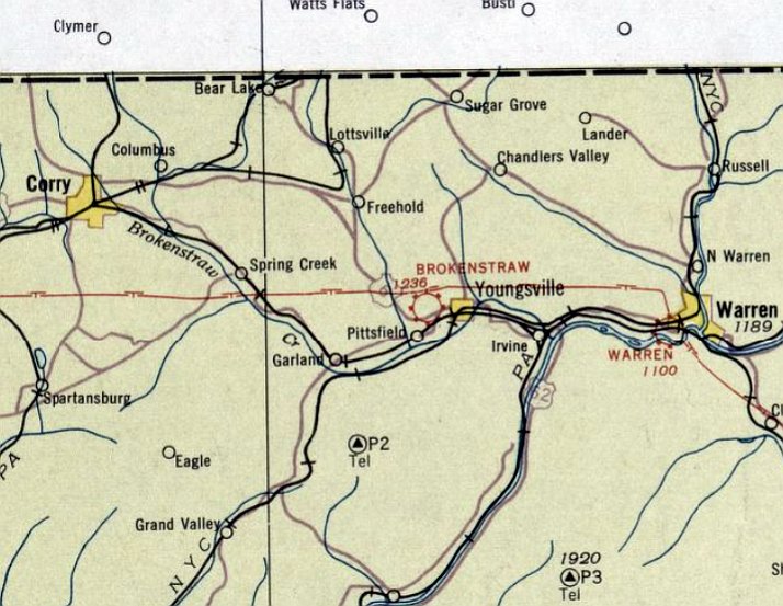
The May 1934 Cleveland Sectional Chart depicted Brokenstraw Field as a commercial/municipal airport.
Brokenstraw Field may have been closed at some point between 1934-35 (possibly due to the Depression?),
as it was no longer depicted on the 1935 Cleveland Sectional Chart.
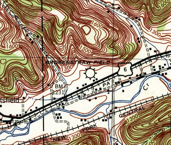
The only topo map depiction which has been located of Brokenstraw Field was on the 1943 USGS top map.
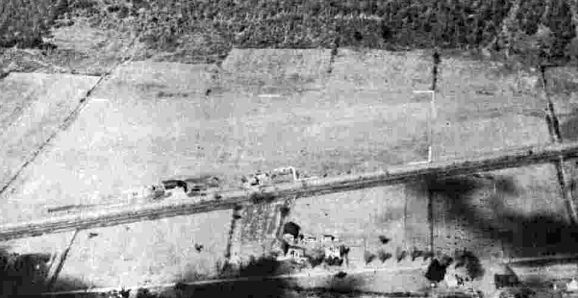
A 10/26/43 aerial view looking north at Brokenstraw Field from the 1945 AAF Airfield Directory (courtesy of Scott Murdock).
It depicted Brokenstraw as an irregularly-shaped grass airfield area with some buildings along the south side.
The 1945 AAF Airfield Directory (courtesy of Scott Murdock) described Brokenstraw Airport as a 40 acre property having a 2 sod runways, the longest measuring 1,650' northwest/southwest.
The field was said to have 1 hangar, and to be owned & operated by private interests.
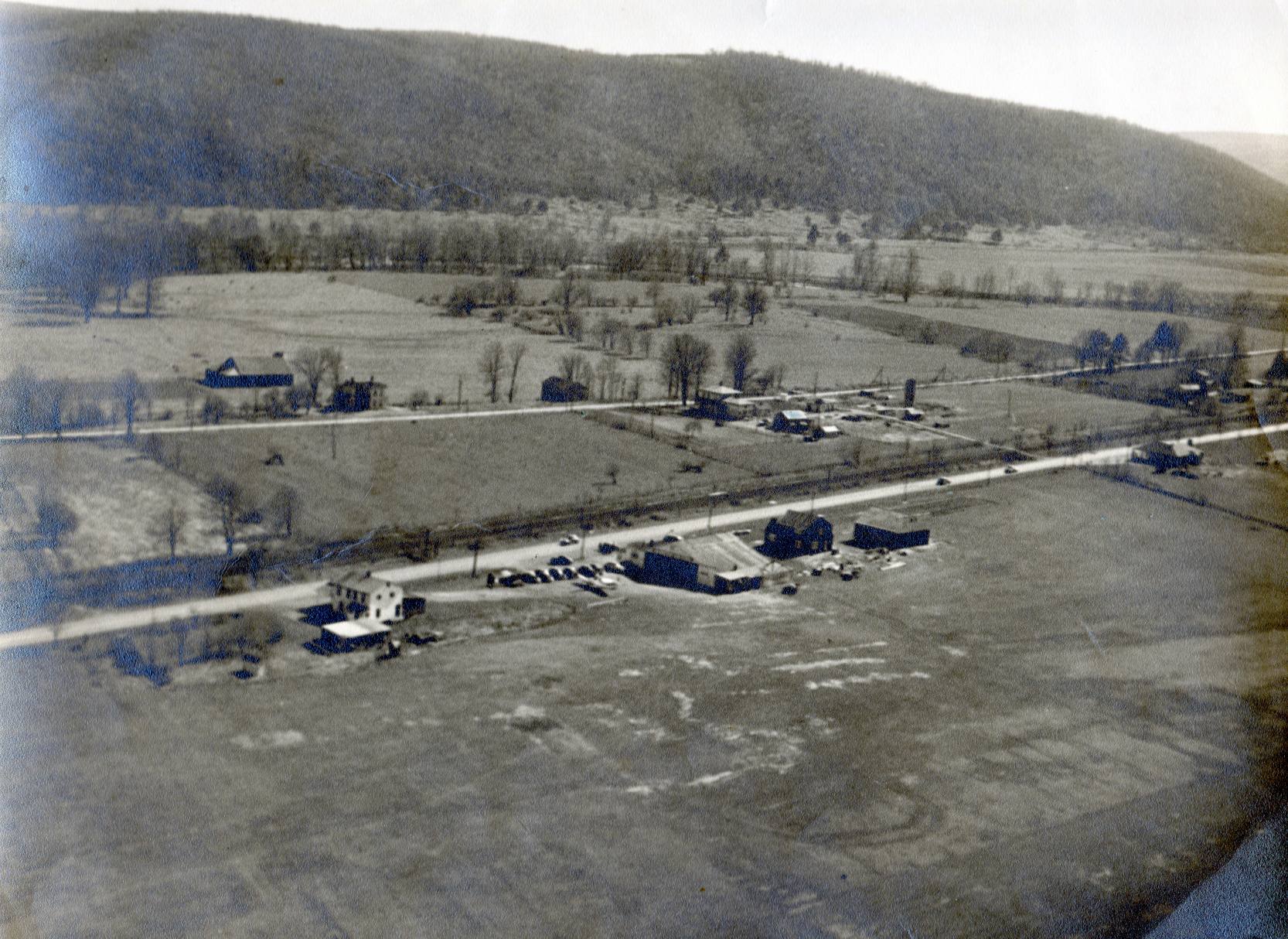
A 1946 aerial view looking south at Brokenstraw Field (courtesy of Stephen Castano) depicted 1 light single-engine plane parked near a hangar, on the south side of a grass airfield.
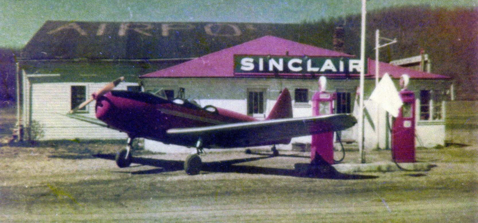
A circa 1940s photo of a surplus Fairchild PT-19 trainer parked at the Sinclair gas pumps, with Brokenstraw Field's hangar (with “Airport” painted on its roof) behind the gas station (courtesy of Stephen Castano).
Brokenstraw Field was still no longer depicted on the 1946 Cleveland Sectional Chart.
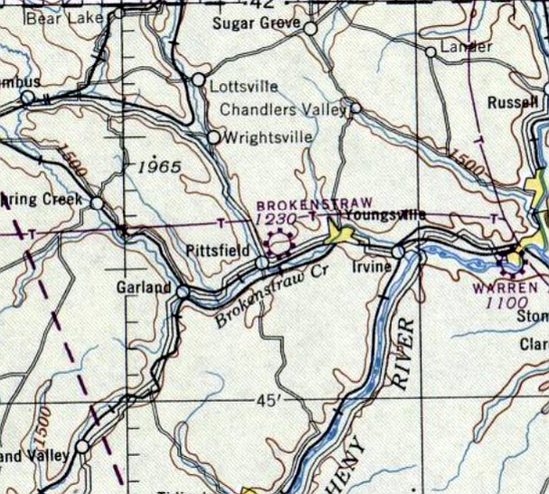
Brokenstraw Field was once again depicted on the January 1947 Cleveland Sectional Chart.
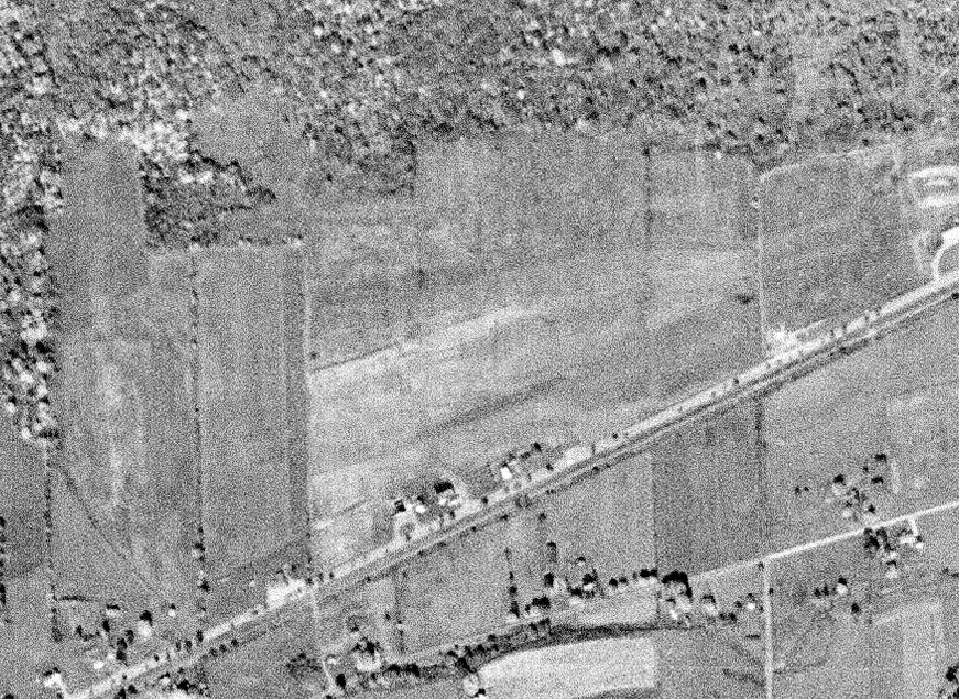
A 10/8/56 USGS aerial view depicted Brokenstraw Field as having a row of buildings along the south side of an southwest/northeast grass airfield.
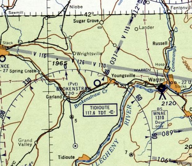
The last depiction which has been located of Brokenstraw Field was on the January 1961 Cleveland Sectional Chart.
It depicted Brokenstraw as a private airfield having a 2,800' unpaved runway.
Brokenstraw Field was evidently closed at some point between 1961-63,
as it was no longer depicted on the May 1963 Cleveland Sectional Chart.
Candy Sargent reported, “My family bought the Brokenstraw Airport property in the 1970s & sold it in the 1990s.”
A 1966 aerial view showed the east/west grass runway remained clear, but there were no aircraft seen on the property.
According to Stephen Castano, “In 1970 the new & present Brokenstraw Airport was built” less than a half-mile to the southwest.
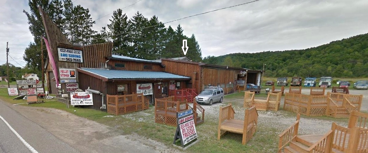
June 2018 photo (courtesy of Stephen Castano) looking northwest at the site of Brokenstraw Airport,
with an arrow denoting the roofline of the former hangar around which the Williams Lumber buildings have been constructed.
The former runway is in the background, behind the row of trucks at the right.
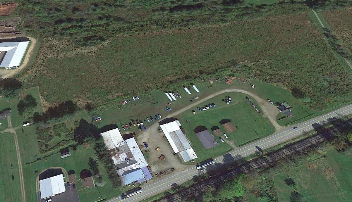
A 2019 aerial view looking north at the site of Brokenstraw Airport.
Thanks to Stephen Castano for pointing out this airport.
____________________________________________________
Carlson Airport (PN06), Edinboro, PA
41.9, -80.1 (Southeast of Erie, PA)
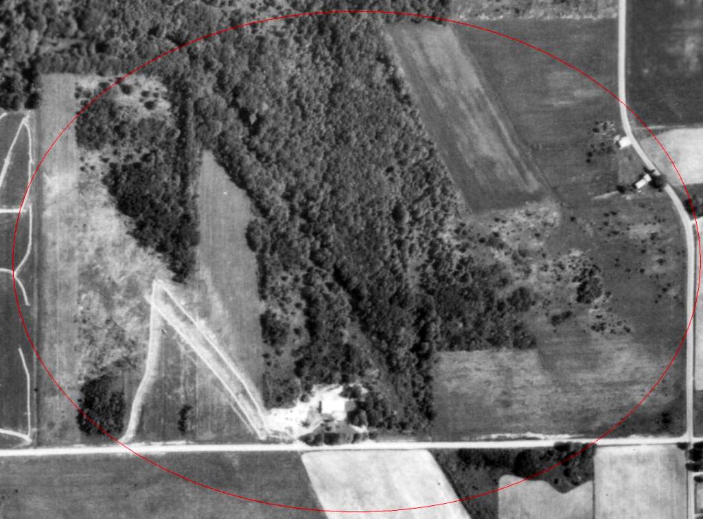
The beginnings of Carlson Airport (circled in red) on a 1969 aerial view (courtesy of Richard Finley).
Carlson Airport was not yet depicted on a 1964 aerial photo.
According to Richard Finley, “Roy [Carlson] was quite a character.
We discovered Civil Air Patrol has a regulation that prevents CAP corporate aircraft from operating at unpaved fields but what Roy offered CAP was just too good to pass up.
He not only did our annuals but he would let us bring the airplane down & put it in his hangar while the annual was being done.
We could work on the plane (under his supervision) which saved us bunches & bunches of money & it was inside out of the weather.
I did a lot of instructing out of Roy's airport thus was quite familiar with it.
Because of the grass field restriction, I (being Group 50's operations officer) set a requirement that only I could operate the corporate plane to & from Carlson airport
and that was restricted to maintenance/inspections.”
Richard continued, “Roy Carlson was a licensed aircraft mechanic with an Inspection Authorization (what you need to do an annual inspection on an airplane).
Roy was also an outstanding mechanic. He had been around the business so long he just naturally understood things that ordinary mechanics were still learning.
As an example, when I first took [Cessna 172] N5130F to him for an annual, he found a problem during the inspection that was extremely serious.
While inspecting the flap system, he noticed a strange noise during the flap operation.
While most people would have ignored it because it was a very light sound & did not seem to affect the operation of the flaps.
Roy got out a flashlight & looked inside the wing. It took a little bit of searching & exercising the flap system but he found it.
He discovered somebody had installed a bolt into a cable connector in the flap system that was much too long.
The odd thing here was the real problem was not in the flap system. It was that the end of this long bolt had been strumming the aileron cable for the right wing.”
Richard continued, “Roy was quite the engineer too.
I went out there one day & found him building a new hangar so he could rent out hangar space.
First, he laid out & poured the concrete hangar floor with no walls around it.
Then he laid out - what looked like additional floor sections – each along the edge of the primary floor he had poured.
Each of these floor sections had several steel eye-bolts embedded into the edge away from where they matched the primary floor.
After he poured these new sections, Roy brought over an old crane he had acquired years before.
He used the crane to raise those new sections into place. They were the walls.
The next thing I knew, he had a new concrete hangar that he constructed in record time.”
Richard continued, “Roy knew just about everybody in Edinboro. People were always stopping in to see him.
He had an office but more often than not, when somebody came to visit, he would go over to this old dirty, dusty & tattered leather recliner off to one side of the garage.
It was like he held court there - Roy, Emperor of Edinboro. He always wore the same old, dirty mechanic's coveralls.
If it was cold, he would wear his old, dirty and tattered insulated ski jacket, the same one he had been wearing for the last 20 years.
When it was cold, he also wore one of those bright orange hunting hats that have the ear protectors that snap together over top the head when not in use.
Roy, of course, never snapped them so they hung out in mid air on either side of his head.
We used to joke that he looked like Deputy Dog when he wore that thing.
Roy had a habit of talking at a slow pace. It gave him the undeserved appearance of being a little slow & uneducated.”
Richard continued, “I have had the occasion to have somebody who did not know Roy with me when I went to see him.
After we left they were surprised when I told them, 'Roy is not, as his appearance tends to indicate, a rum-soaked old dullard who just wandered in from the homeless shelter.
He is actually a successful businessman who owns his own airplane, owns his own airport and is on the board of directors of Marine Bank.'”
Richard continued, “The main runway was 2,500' long but the secondary runway was only 1,600' long.
Roy's hangar was located near the southeast end of the secondary runway.
Runway 33 was the 1,600' runway. It ran fairly level for the first 900-1,000' before it began to pitch down more & more steeply until it ended.”
The earliest photo which has been located of Carlson Airport was a 1969 aerial view (courtesy of Richard Finley).
It depicted possibly the early clearing of the runways.
However, Carlson Airport was not depicted at all on the May 1970 Cleveland Sectional Chart,
or USGS topo maps from 1972/76/88.
A 1982 aerial photo depicted Carlson Airport as having 2 grass runways, with a few small buildings on the southwest side.
There were no aircraft visible on the field.
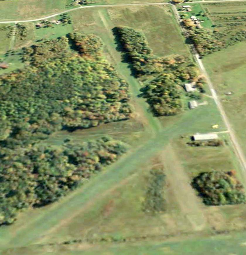
The only photo which has been located showing an aircraft at Carlson Airport was an 8/4/06 aerial view looking east,
which showed a yellow single-engine aircraft parked on the south side.
Richard Finley reported in 2014, “Roy Carlson's airport is one of the latest casualties.
Roy died & nobody is keeping the airport in usable condition. Last report I heard was that the grass is too high to operate safely from the airport.”
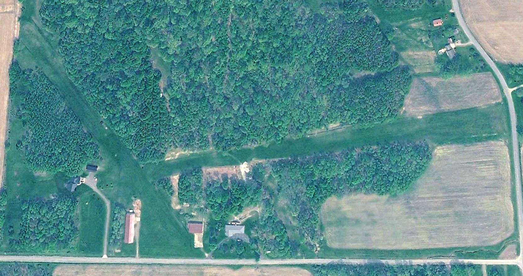
A 2023 aerial view showed Carlson Airport to remain recognizable, but a house had been built a some point between 2013-2023 on the west side of the east/west runway.
Carlson Airport is located northwest of the intersection of Crane Road & Hamilton Road.
Thanks to Richard Finley for pointing out this airport.
____________________________________________________
Culbertson Hills Airport / Edinboro Airport, Edinboro, PA
41.87, -80.15 (Southeast of Erie, PA)
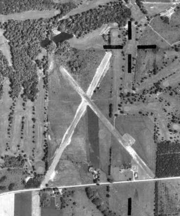
A 1969 aerial view of Culbertson Hills Airport (courtesy of Richard Finley).
Culbertson Hills Airport was not yet depicted on a 1964 aerial photo.
According to Richard Finley, “Culbertson Hills Airport was apparently associated with Culbertson Hills Golf Course.
The whole enterprise was a little over-ambitious for the location.
They had the golf course, the airport & a Holiday Inn hotel. It fizzled leaving the golf course as the sole survivor.
I used to fly up to Culbertson Hills to pick up/take back my sister who was a student at Edinboro University.
I picked up a student who kept his airplane down there.”
Richard continued, “I was over at Erie Airways training department one evening when I was working on my Double-I.
One of the instructors took a call. He spoke to the caller for a short time then asked the other instructor if he knew of anybody qualified to instruct in a taildragger.
The other instructor's comment ('What's a taildragger?') shows flying conventional gear airplanes is becoming a lost art.
I did not want to ruffle any feathers. Since I had a full time aviation job at the tower, some of the FBO people resented me taking work from them.
On the other hand, from my perspective, I took the jobs they did not want or could not do.
I asked if they would mind if I talked to the gentleman. They said it was no problem so I introduced myself.
It turns out this guy was a NFL player who was a New England Patriot out for the rest of the season with a knee injury.
He had a Citabria he just bought. He had been working on his private license at an airport near Boston flying a Cessna 172 (because he would not fit in a C150).
After he got his license, I had a couple of occasions to go down to Culbertson Hills & borrow the Citabria to do some spin training.
Culbertson Hills does not appear on the November 1968 Cleveland Sectional.
I am not sure when it closed. I think it just slowly & quietly fell into disuse until, one day, the owner decided the unused airport would be a good place to expand the golf course.”
The earliest photo which has been located of Culbertson Hills Airport was a 1969 aerial view (courtesy of Richard Finley).
It depicted the field as having 2 unpaved runways, with some small buildings on the southeast side.
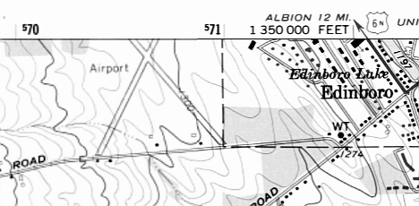
The 1975 USGS topo map depicted Culbertson Hills as having 2 runways, labeled simply as “Airport”.

The 1986 USGS topo map depicted Edinboro Airport as having 2 runways.
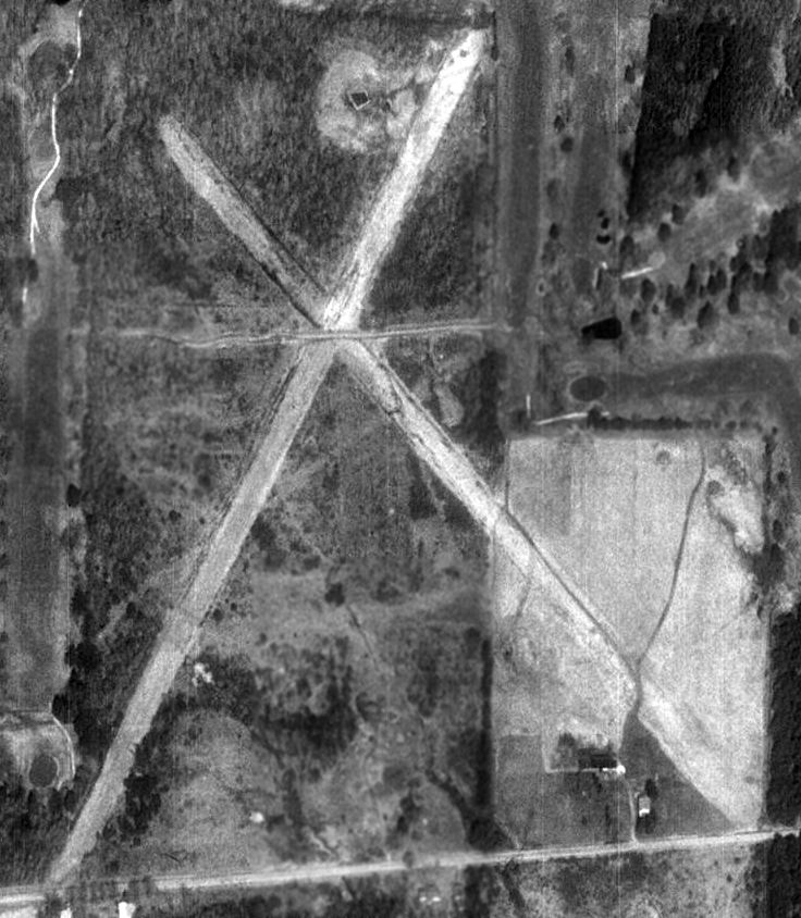
A 4/16/93 USGS aerial photo showed Edinboro Airport still largely intact, though deteriorated.
A 2005 aerial photo showed the golf course had begun to expand over the former Edinboro Airport runways.
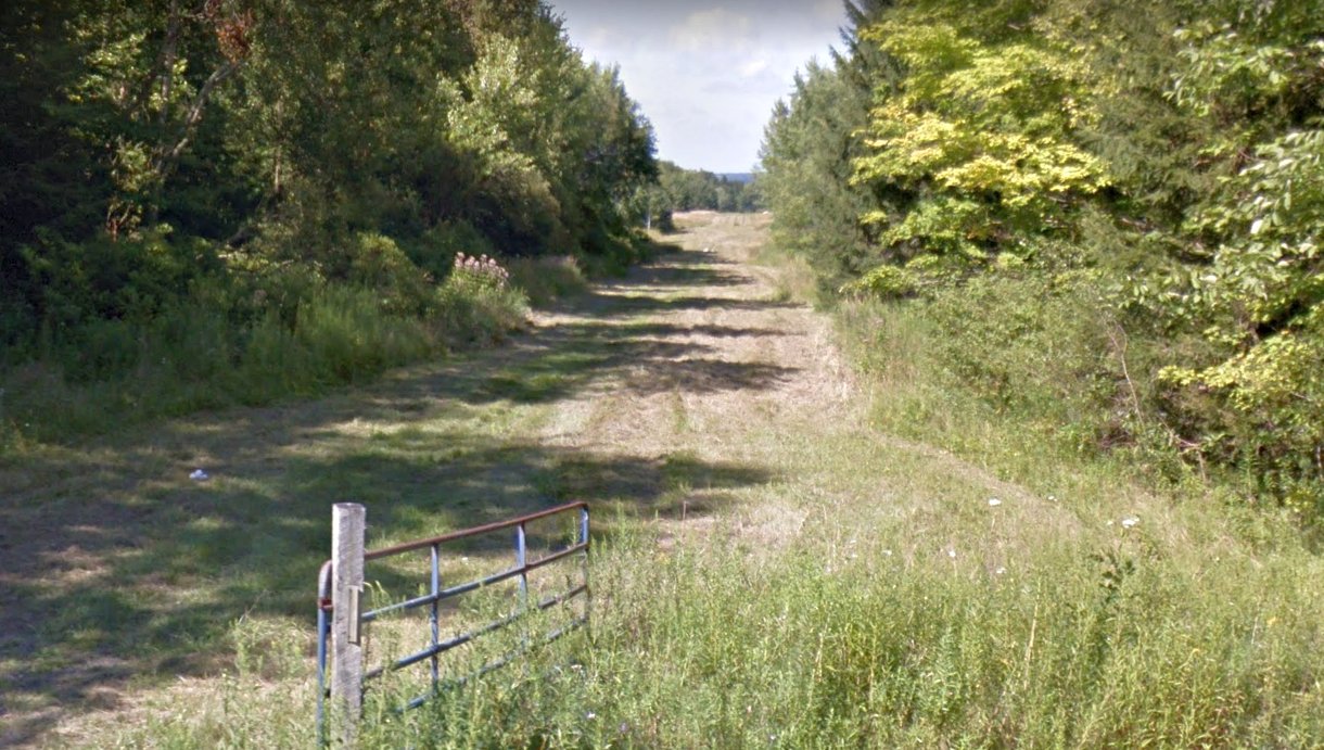
An August 2013 photo looking northeast showed Edinboro Airport's former northeast/southwest runway remained clear.
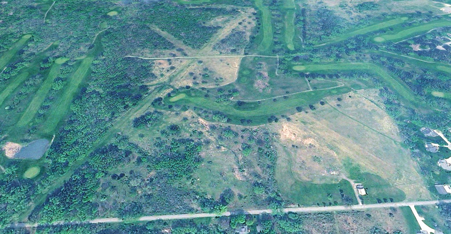
A 2023 aerial view looking north showed the Edinboro Airport runways were still recognizable, though the golf course overlaid the eastern portion.
The site of Edinboro Airport is located northeast of the intersection of Sherrod Hill Road & Forrest Drive.
Thanks to Richard Finley for pointing out this airport.
____________________________________________________
(Original) Erie County Airport, Fairview, PA
42.02, -80.26 (Southwest of Erie, PA)
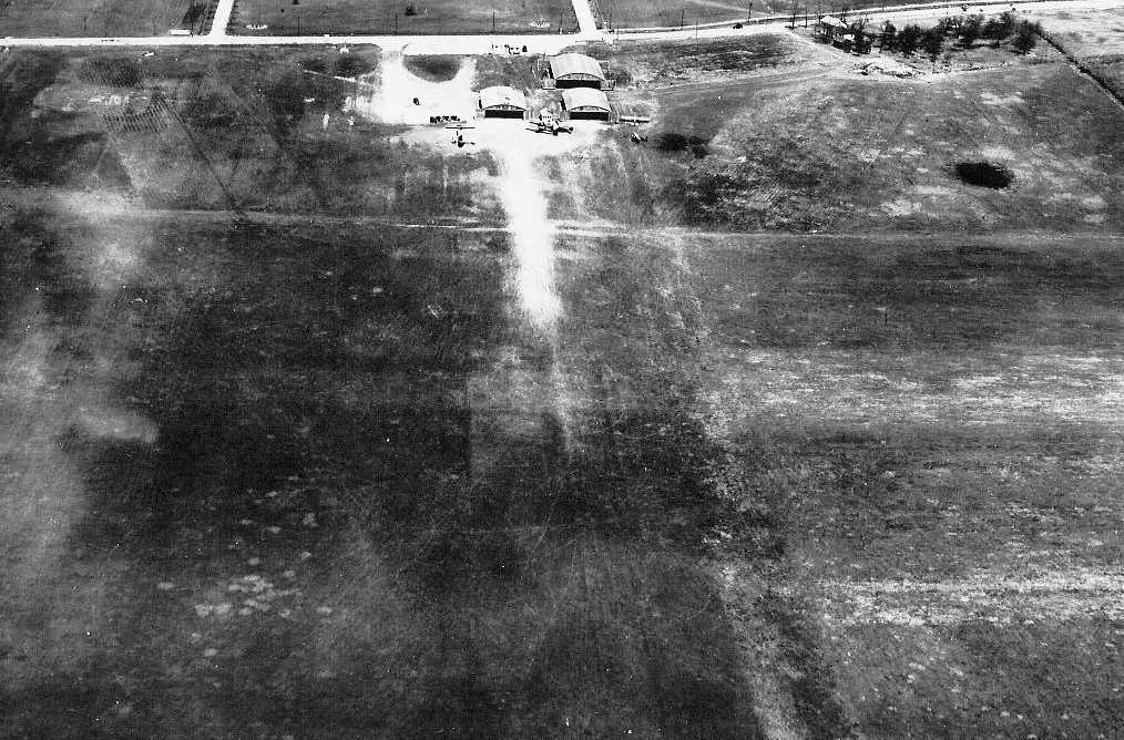
A 1930 aerial view looking north at the original Erie County Airport (courtesy of Richard Finley).
According to Richard Finley, the original “Erie County Airport... opened in 1928, located in Fairview southwest of Erie.
According to the book “Erie County”, “Neil McCray started the Fairview Airport in 1928, and Jerry Richardson worked for him.
Famous pilots Wiley Post & Amelia Earhart came to the airport.”
The earliest depiction which has been located of the original Erie County Airport was a 1930 aerial view (courtesy of Richard Finley),
which depicted 3 hangars & several aircraft on the north side of a grass airfield.
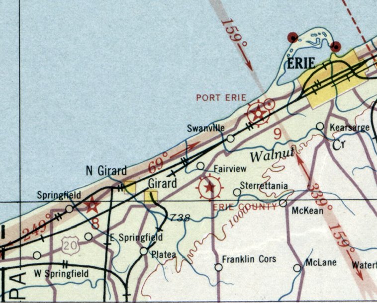
The earliest aeronautical chart depiction which has been located of the original Erie County Airport was on the June 1931 Detroit Sectional Chart,
which depicted Erie County as a commercial/municipal airport.
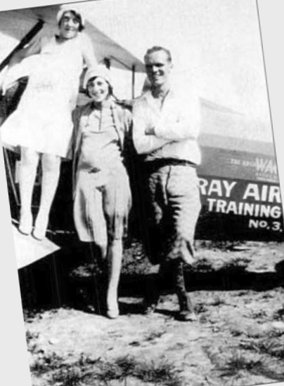
A circa 1930s photo of Jerry Richardson preparing to take 2 flappers for a ride in a Waco at Erie County Airport (courtesy of Richard Finley).
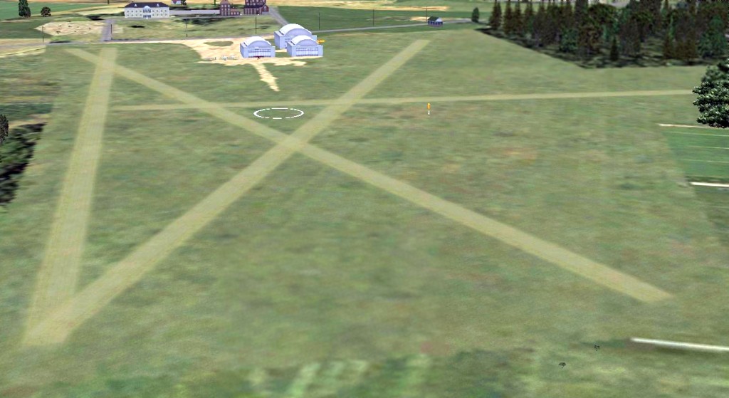
A Flight Simulator scenery re-creation by Richard Finley looking north at Erie County Airport.
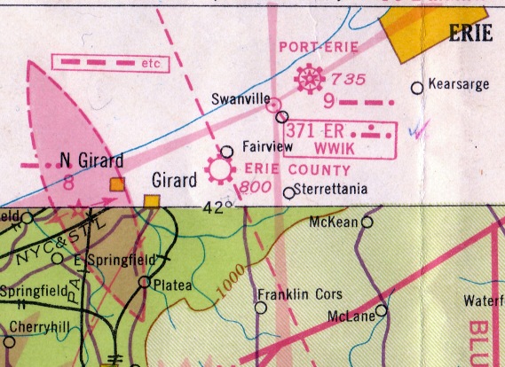
The March 1940 Cleveland Sectional Chart (courtesy of Richard Finley)
depicted Erie County as a commercial/municipal airport.
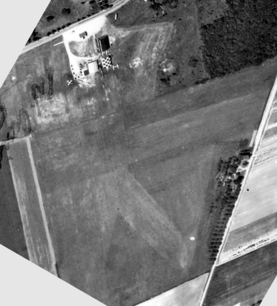
A circa 1940s aerial view of the original Erie County Airport (courtesy of Richard Finley).
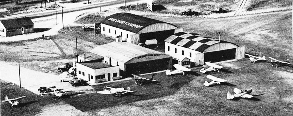
A circa 1950s aerial view looking north at the hangars & planes of the original Erie County Airport (courtesy of Richard Finley).
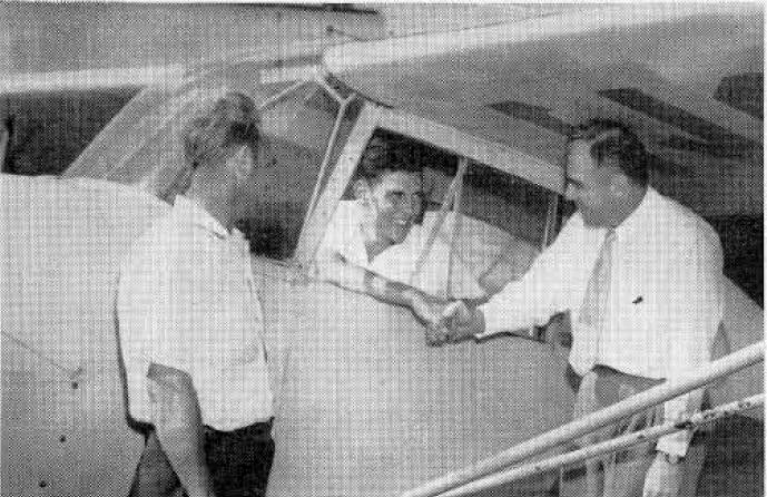
An undated photo from a November 1954 magazine article (courtesy of Richard Finley)
showing Mike Kudlak (instructor) watching 16 year old Doug Bashioum
being congratulated by his father Jake on the occasion of his 1st solo flight at Erie County Airport,
the same spot where his father had soloed 25 years before.
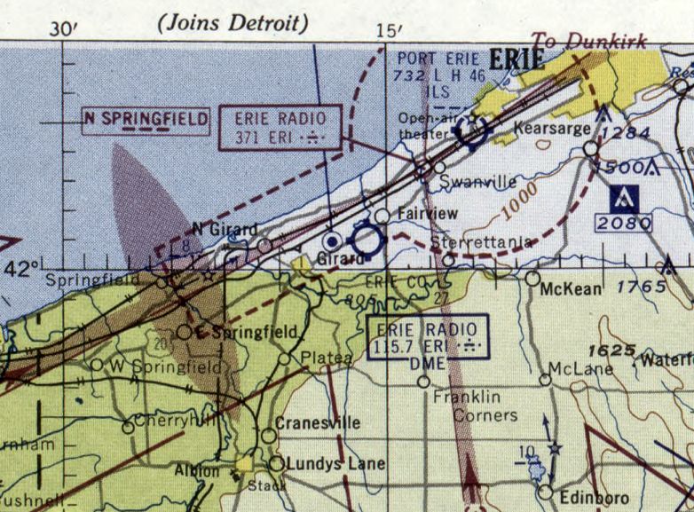
The last aeronautical chart depiction which has been located of the original Erie County Airport was on the January 1955 Cleveland Sectional Chart,
which depicted Erie County as having a 2,700' unpaved runway.
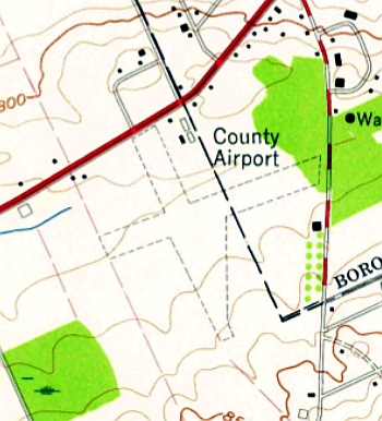
The 1957 USGS topo map depicted “County Airport” as having 2 unpaved runways & 4 small buildings on the north side.
According to Richard Finley, the original Erie County Airport “was last operated by the Kudlak brothers who closed it in 1957
and moved to the Erie airport where they started Erie Airways.”
The January 1958 Detroit Sectional Chart no longer depicted Erie County Airport.
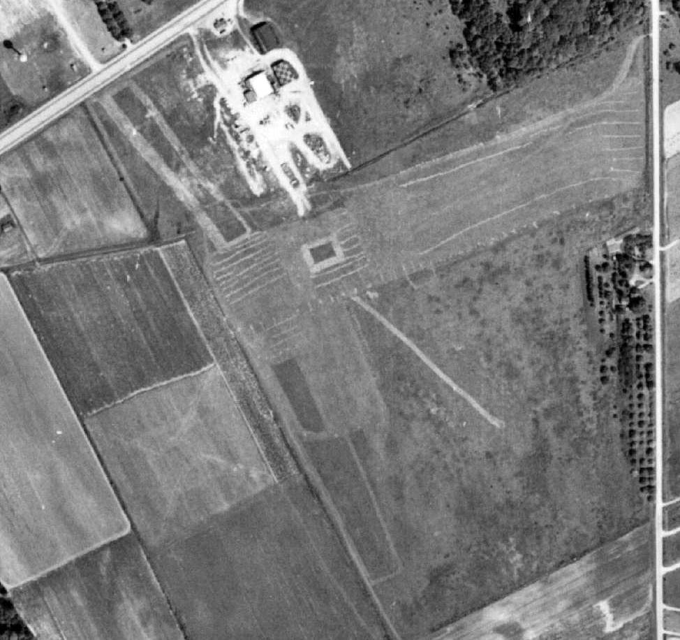
A 1959 aerial view (courtesy of Richard Finley) showed that the 3 hangars remained standing,
but there were no aircraft visible on the field, and the grass runways appeared to no longer be in use.
The 1970 USGS topo map labeled the site of Erie County Airport as “Fairview Evergreen Airport”,
but that is erroneous, as the Fairview Evergreen Airport is a separate facility located about a mile to the east.
The 1976 USGS topo map no longer depicted any airport at the site, but continued to depict the 3 hangars.
A 1988 USGS aerial photo showed the 3 hangars had been removed at some point between 1976-88.
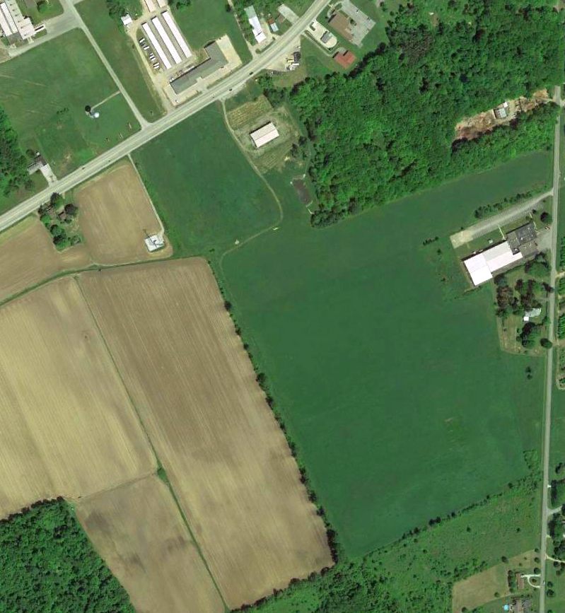
A 5/25/13 aerial photo showed no trace remaining of the original Erie County Airport.
The site of the original Erie County Airport is located southwest of the intersection of Route 20 & Franklin Road.
Thanks to Richard Finley for pointing out this airport.
____________________________________________________
(New) Erie County Airport (3G1), Wattsburg, PA
42.04, -79.85 (Southeast of Erie, PA)
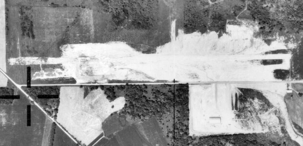
A 5/31/69 aerial view of the Erie County Airport under construction (courtesy of Richard Finley).
The Erie County Airport at this location was not yet depicted on the 1962 USGS topo map.
The earliest depiction which has been located of the Erie County Airport in Wattsburg was a 5/31/69 aerial view (courtesy of Richard Finley),
which showed the field still under construction.
The hangar was already erected, and a single paved east/west runway was being graded.
According to Richard Finley, “Erie County Airport was built by Tom Mountain.
Tom was a businessman/pilot who owned some auto parts stores around Erie.
He sold them & went into the business of buying/selling construction equipment.
Tom had quite a deal going there. He was a pilot.
He always wanted his own airport so he combined the two functions.
He bought/sold/traded construction equipment. While he had machinery on hand, he would use it to build his airport.
He was doing excavation the average land owner could only dream of doing.
If he sold the bulldozer he was using, he grabbed another one out of inventory & used that.
He built a very nice east/west runway & was working on a north-south runway.”
The Erie County Airport at this location was not yet depicted on the May 1970 Cleveland Sectional Chart.
According to its FAA Airport/Facility Directory data, Erie County Airport was activated in November 1971.
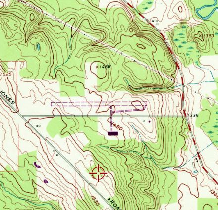
The earliest topo map depiction which has been located of the Erie County Airport was on the 1972 USGS topo map.
It depicted a single unpaved east/west runway with a taxiway leading to a building on the south side, but strangely did not label the airport.
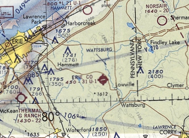
The earliest aeronautical chart directory which has been located of the Erie County Airport was on the November 1972 Detroit Sectional Chart.
It depicted Erie County as having a 3,100' paved northeast/southwest runway.
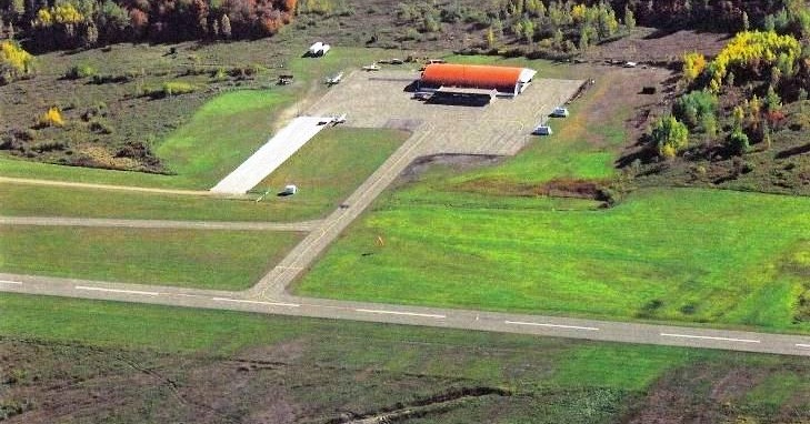
The earliest photo which has been located showing the Erie County Airport in operation was a circa 1970s aerial view looking south (courtesy of Richard Finley),
showing 3 single-engine aircraft parked on the ramp next to the hangar.
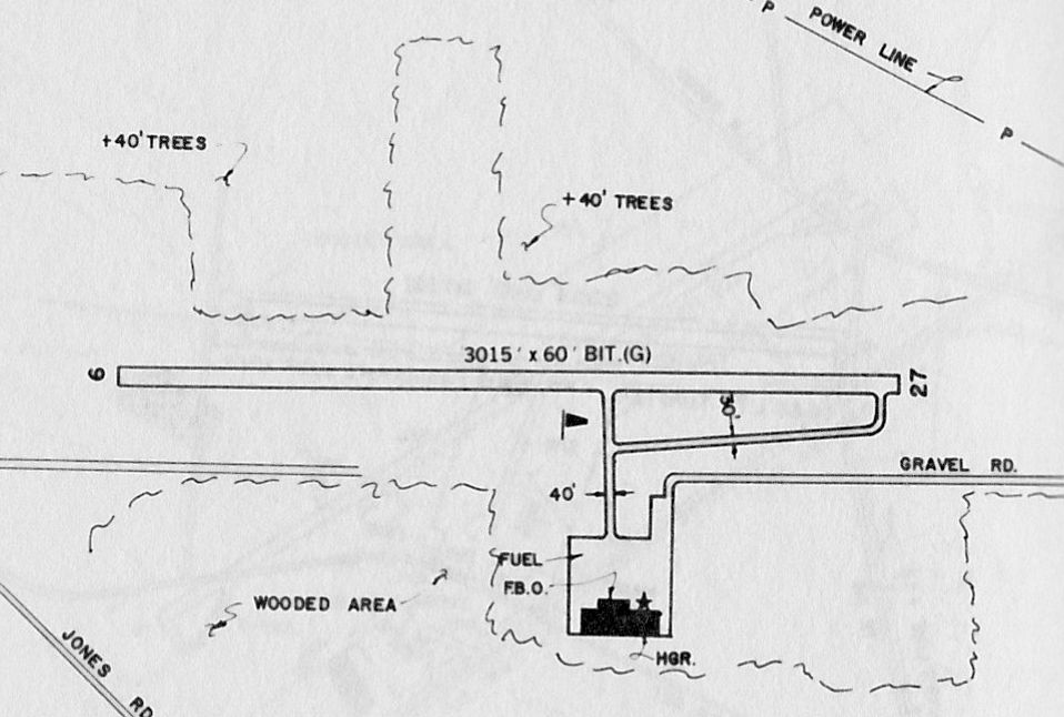
The 1983 PA Airport Directory depicted Erie County Airport as having a 3,015' bituminous Runway 9/27
with a taxiway leading to a ramp, hangar, and FBO on the southeast side.
Richard continued, “He [Tom Mountain] wanted to run a full-service airport.
He was doing hangar space rental, aircraft rental/sales, flight instruction, maintenance, sold parts and pilot supplies – you know – the whole enchilada.
Then the fit hit the shan. When he put in for the certificates he needed to operate, he knew they would reassess the facilities he built.
When he bought the property it was assessed as vacant land & his taxes were something like $2,500.
When they reassessed, they reassessed the entire property to business, not just the parts that he improved.
His tax load went to something like $40,000!
If he wanted to protest that, he could not just say, 'This is killing me.'
He had to shut down the business & sell off the assets. Then he could show there was a negative impact.
He did that but it seemed he never really recovered.
He & his wife tried to keep the airport open by themselves but the last I heard, the airport was physically still there but closed.”
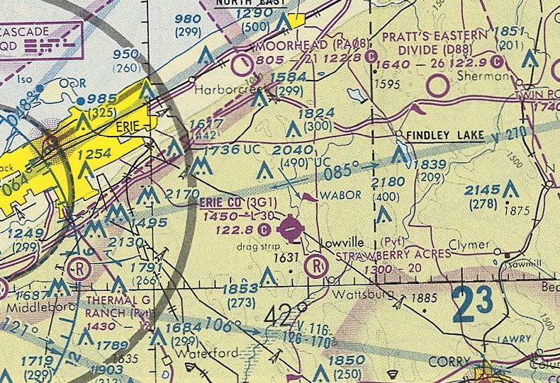
The last aeronautical chart depiction which has been located showing Erie County Airport open was on the October 1993 Detroit Sectional Chart.
It depicted Erie County as having a 3,000' paved northeast/southwest runway.
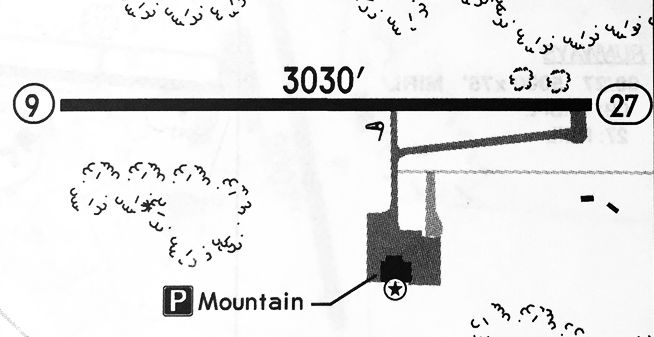
A 1994 airport directory (courtesy of Gwen Shafer) depicted Erie County Airport as having a 3,030' paved Runway 9/27
with a taxiway leading to a ramp & hangar on the southeast side, which housed Mountain Aviation Company.
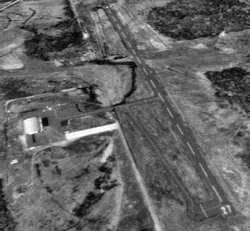
The last photo which has been located showing the Erie County Airport in operation was a 4/20/94 USGS aerial view looking northwest.
Two single-engine aircraft were visible on the ramp next to the hangar.
According to David Tulis, “Health forced [Tom] Mountain to close the airport in 1996.”
However, other subsequent indications show the airport open at later dates.
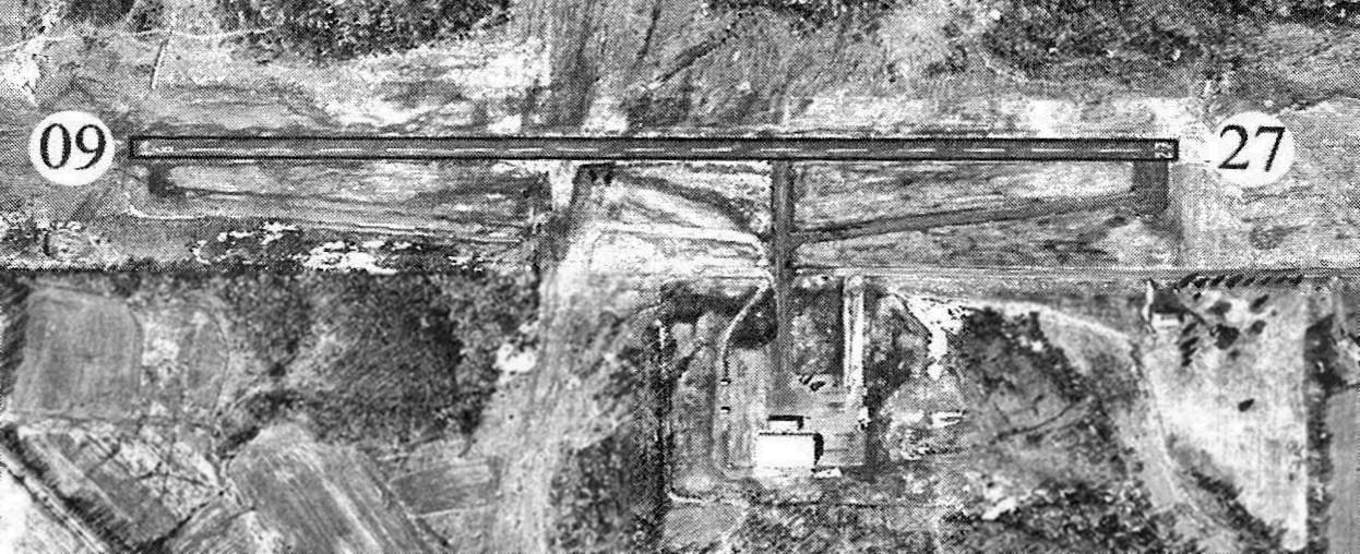
The last airport directory listing which has been located of Erie County Airport was in the 2005 PA Airport Directory (courtesy of John Clifford).
The directory described Erie County as having a 3,030' asphalt Runway 9/27, and listed the manager as Thomas Mountain.
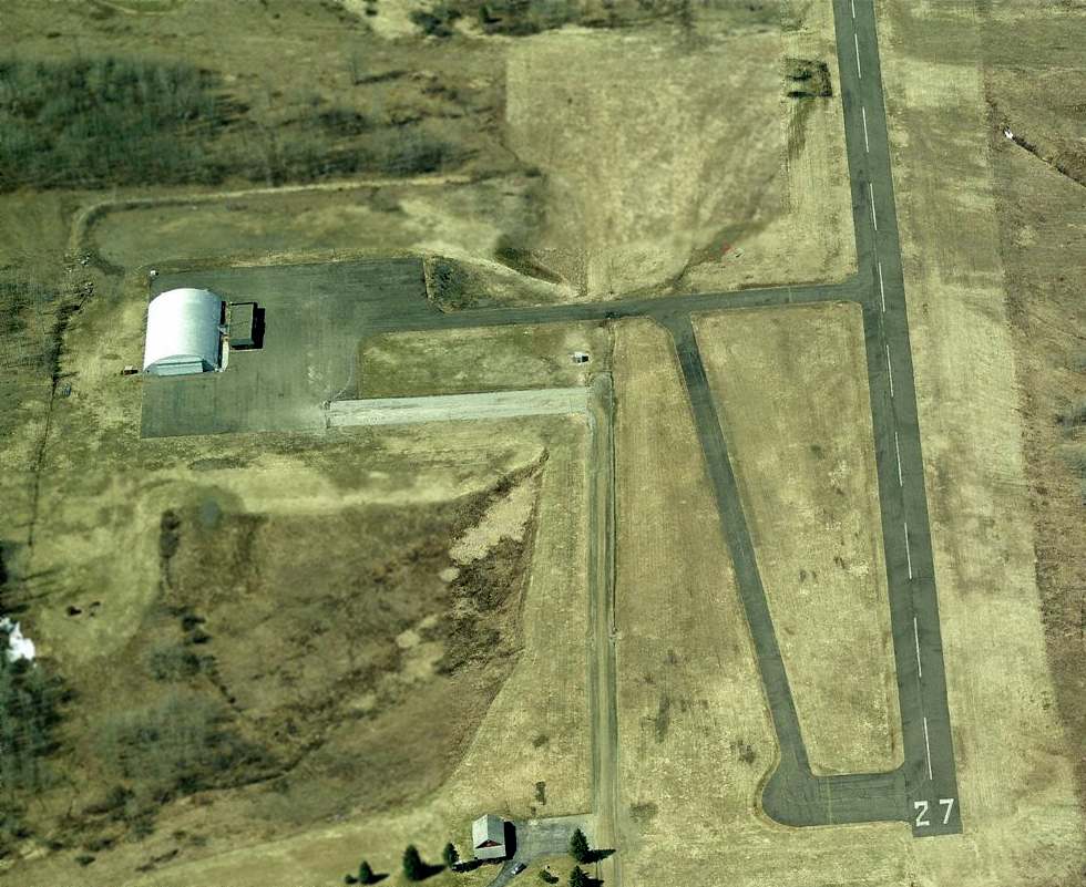
A circa 2008-2013 aerial view looking west at Erie County Airport,
showing Runway 27 still marked as an active runway, and the hangar & ramp remained intact,
though there was no sign of any aviation usage.
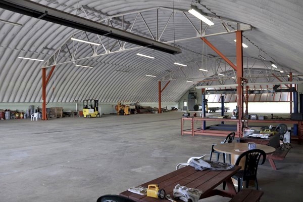
A 2009 photo by David Tulis of the “fully-insulated hangar for winter snows.”
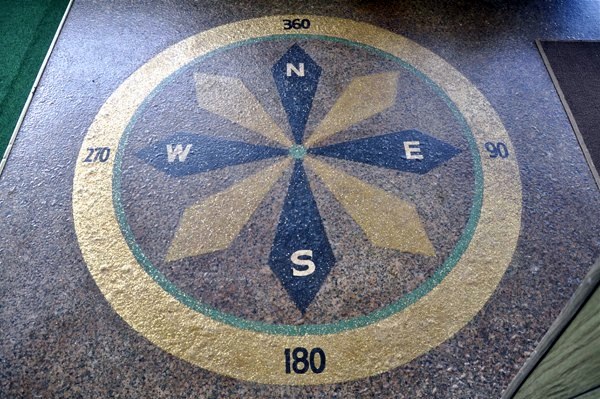
A 2009 photo by David Tulis of the “compass mosaic on the floor of the terminal.”
David Tulis reported, “Owner Tom Mountain, 82, hopes for a buyer for his 335-acre gem.
I enjoyed meeting him in 2009 on a flight to Erie in my 1968 Mooney M20C.
A friend of mine was interested in purchasing the place because my friend grew up near there.
The facility was in good shape & Tom had ideas for a super-nice steak house, or some kind of inn or spa co-located at the airport.
He apparently had a small diner at the main FBO building for awhile & entertained Saturday fly-ins & such.
It would be great to save this place!”
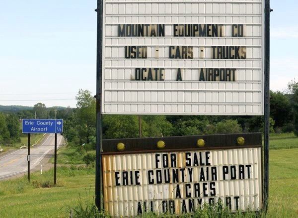
A 2009 photo by David Tulis of the sign for Erie County Airport.
David observed, “Got a million-point-five? It could be yours.”
As of August 2010, 13, the FAA Airport/Facility Directory described Erie County Airport as conducting an average of 10 takeoffs or landings per year.
A 10/6/11 aerial photo still showed Erie County's runway marked as an active runway.
As of February 2013, the FAA Airport/Facility Directory described Erie County Airport as having a single 3,030' asphalt Runway 9/27 “in fair condition”.
A 5/25/13 aerial photo showed that closed-runway “X” symbols had been painted on both ends of Erie County's runway,
and the taxiway connecting the ramp to the runway had been blocked with a Jersey wall.
The September 2016 Detroit Sectional Chart depicted Erie County Airport as an abandoned airfield.
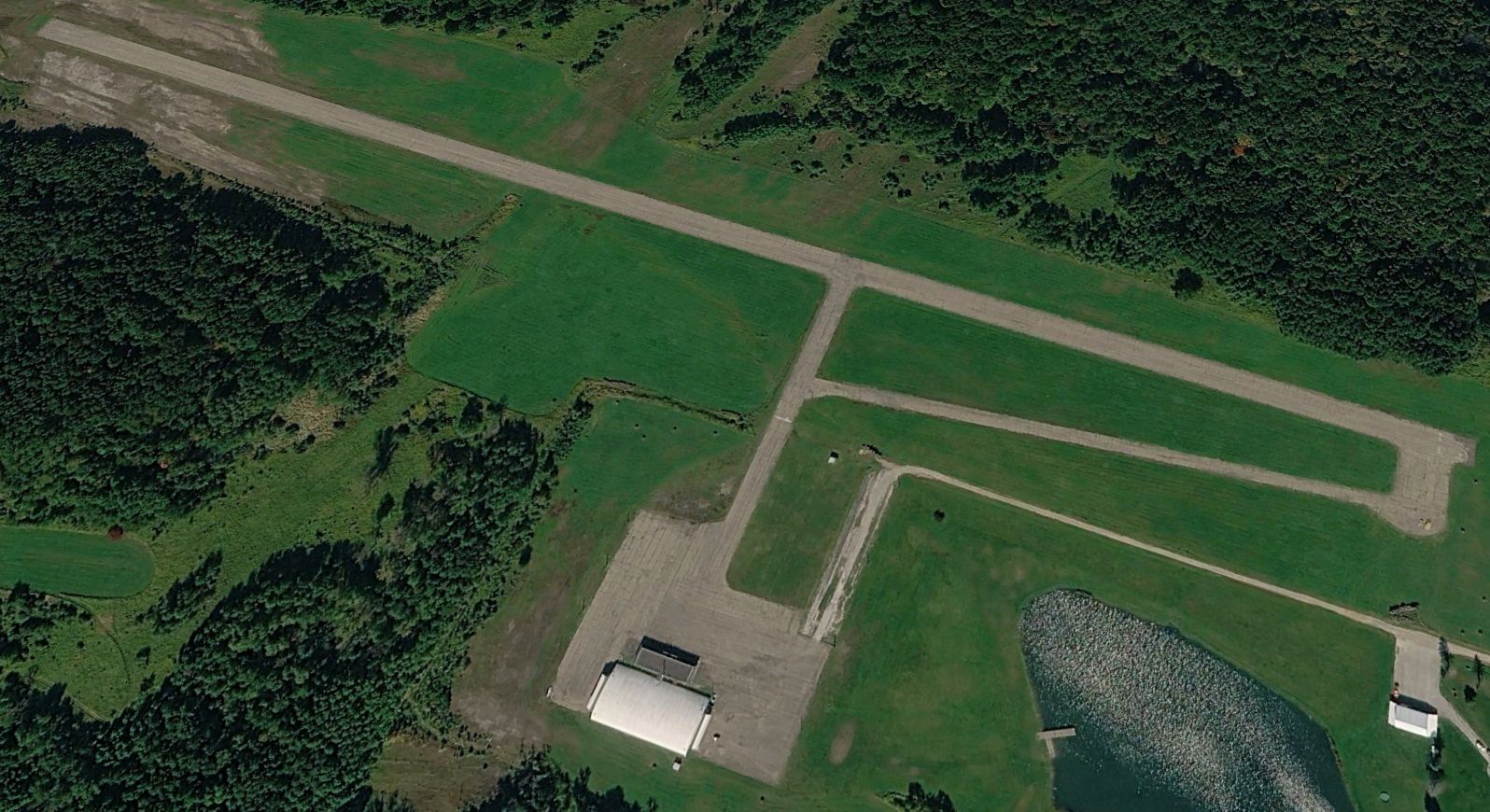
A 2024 aerial view looking northwest showed the former Erie County Airport remained intact. What a shame to see this fine piece of aviation infrastructure not being used.
Erie County Airport is located at the western terminus of Curtis Road.
Thanks to Richard Finley for pointing out this airport.
____________________________________________________
Kearsarge Airport, Kearsarge, PA
42.07, -80.1 (South of Erie, PA)
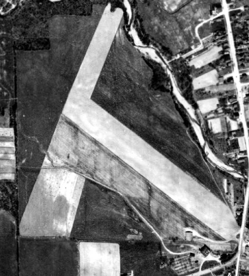
A 4/29/39 aerial view (courtesy of the Pennsylvania Geological Survey) showed Kearsarge Airport to have 2 grass runways.
The date of construction of Kearsarge Airport has not been determined.
It was not yet listed among active airports in The Airport Directory Company's 1937 Airports Directory (courtesy of Bob Rambo),
nor was it depicted on Detroit Sectional Charts from 1931-58.
The earliest depiction which has been located of Kearsarge Airport was a 4/29/39 aerial view (courtesy of the Pennsylvania Geological Survey)
which depicted the field as having 2 grass runways with 2 buildings on the southeast side.
The 1945 AAF Airfield Directory (courtesy of Scott Murdock) did not list Kearsarge among active airfields.
Timothy Kuryla recalled, “In 1947, a woman who was looking after my older sister & me took us to the Kearsarge Airport.
Her son was landing in a private plane & the sitter wanted to visit with him. Thus we got to see the airport.”
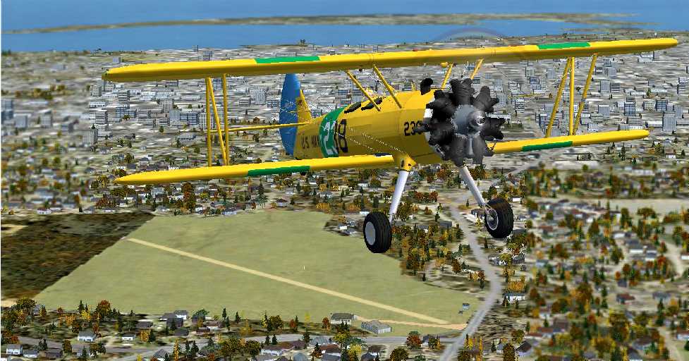
A Flight Simulator scenery re-creation of circa 1950s Kearsarge Airport by Richard Finley, looking north at a Stearman biplane overflying the field.
Kearsarge Airport was not depicted on the 1956 or 1959 USGS topo maps.
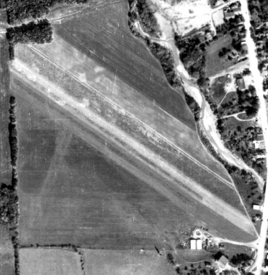
A 10/5/59 aerial photo (courtesy of the Pennsylvania Geological Survey) depicted Kearsarge as having 2 grass runways with 2 buildings on the southeast side.
No aircraft were visible on the field.
According to Richard Finley, “The airport closed in the 1960s & the land sold to a developer.”
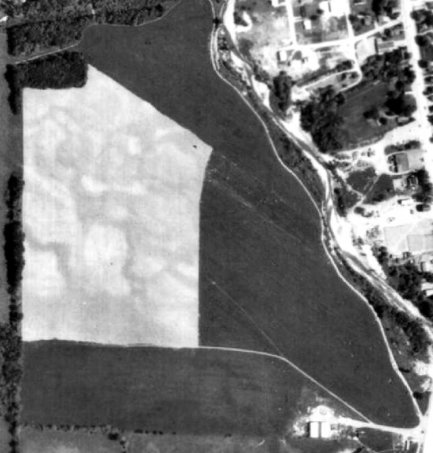
A 5/31/69 aerial photo (courtesy of the Pennsylvania Geological Survey) appeared to depict Kearsarge after the airport's closure,
as the field had been subdivided & no longer bore a runway outline.
The buildings (hangars?) remained at the southeast side, but there was no indication of any recent aviation usage.
In 1975 the Millcreek Mall opened on the site of Kearsarge Airport.
A 1987 USGS aerial photo showed Millcreek Mall covering the site, with no trace remaining of Kearsarge Airport.
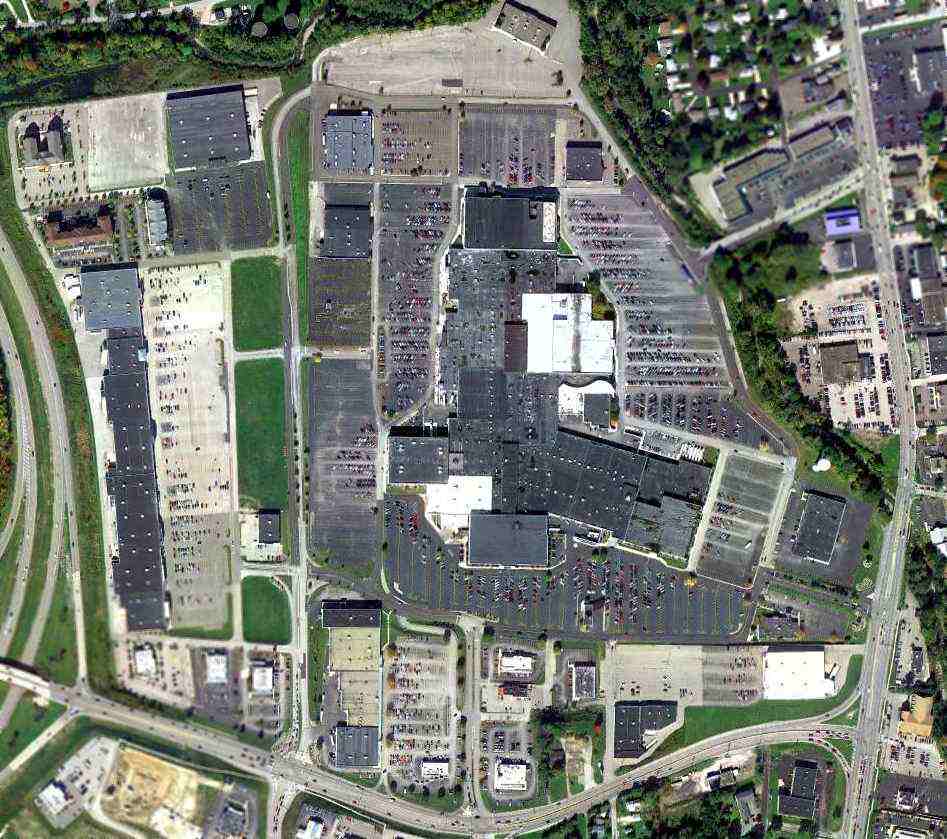
A 10/7/11 aerial view showed no trace remaining of Kearsarge Airport.
The site of Kearsarge Airport is located at the northwest of the intersection of Edinboro Road & Peach Street.
____________________________________________________
41.83, -79.17 (Northeast of Pittsburgh, PA)
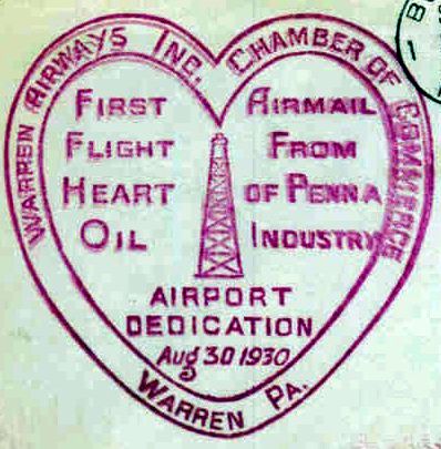
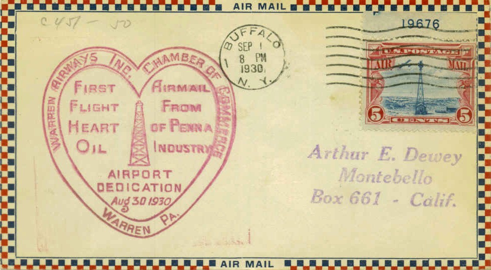
A postmark commemorated the 8/30/30 Dedication of Warren Airport.
This little airport was located on the north side of a bend in the Allegheny River.
A postmark commemorated the 8/30/30 Dedication of Warren Airport.
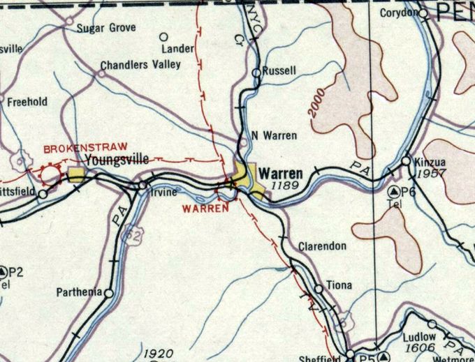
The earliest depiction which has been located of Warren Airport was on the December 1932 Cleveland Sectional Chart.
It depicted Warren as a commercial/municipal airport.
The earliest directory listing which has been located of Warren Airport was in the Airport Directory Company's 1933 Airport Directory (courtesy of Chris Kennedy).
It described Warren as a commercial airport having 3 sod runways, with the longest being the 2,250' east/west & northwest/southeast strips.
A hangar was said to have "Airport" painted on the roof.
Mel Barron recalled, “Warren Airport... I lived across the Allegheny River from the airport before it was an airport, just a big grass field.
The Jameson brothers started Warren Airport. They were oil people, were the Hyvis Oil Company.
They started out with one of those corrugated steel hangars of the day with a small office attached.
Back in the first years of the airport there were no runways at all, you just took off & landed into the wind.
They had 2 Waco RNF biplanes & a Stinson JR monoplane & 2 pilots.
I don't know how long they were in business, but it wasn't very long.
These were the depression years & people didn't have money for flying.
The airport was shut down & deserted for several years;
the hangar was empty except for a Waco model 9 biplane with a liquid-cooled 90 HP Curtiss OX-5 engine.”
Mel continued, “Whoever owned that airplane never did anything with it.
The airport was closed for several years & then Slip King leased it in 1935
and started operating a flying service with a Taylor Cub E-2 & a Travel Air 2000 biplane with a OX-5 engine.
At age 15 in 1935 I took my first flying lesson there. Virgil Slip King wasn't in business very long & he had a disaster.
We had a blizzard & the weight of the snow collapsed the hangar & smashed the airplanes in it.
I'm not sure of the exact number, but it was at least 4 airplanes which included that old Waco 9 biplane.
All that was left still standing was the small office. I'm not sure how long the airport operated without a hangar.
Eventually the WPA came in & built a new hangar out of brick & cement blocks
with an office & apartment built onto the side of it & put in a blacktop runway & tax strip.
They also built a dyke around the airport as the river would flood sometimes covering the airport with water.
There were 2 grass runways until the one was blacktopped. That taxi strip was a part of the other grass runway.
I was never aware of any 3rd runway. Both runways ran from river bank to river bank.
I think the original intention when the hard-surfaced runway & taxi strip were put in
that the airport would have just the one runway, but the grass runway with the taxi strip in it continued to be used.
It saved doing a lot of taxiing.”
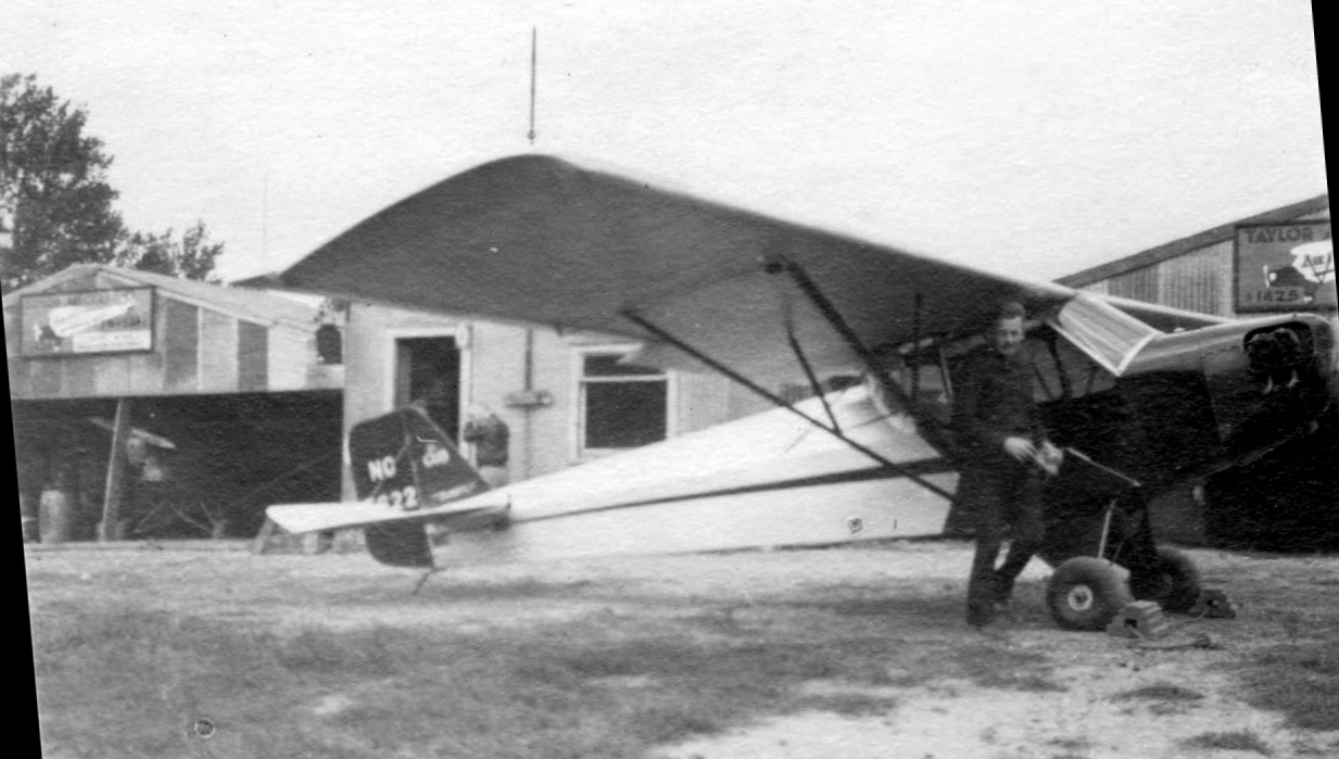
A 1936 photo (courtesy of Stephen Warburton) of Marshall “Mushy” Mathis & his 1935 Taylor Cub (serial #301, registration NC15622) in front of hangars, possibly at Warren Airport.
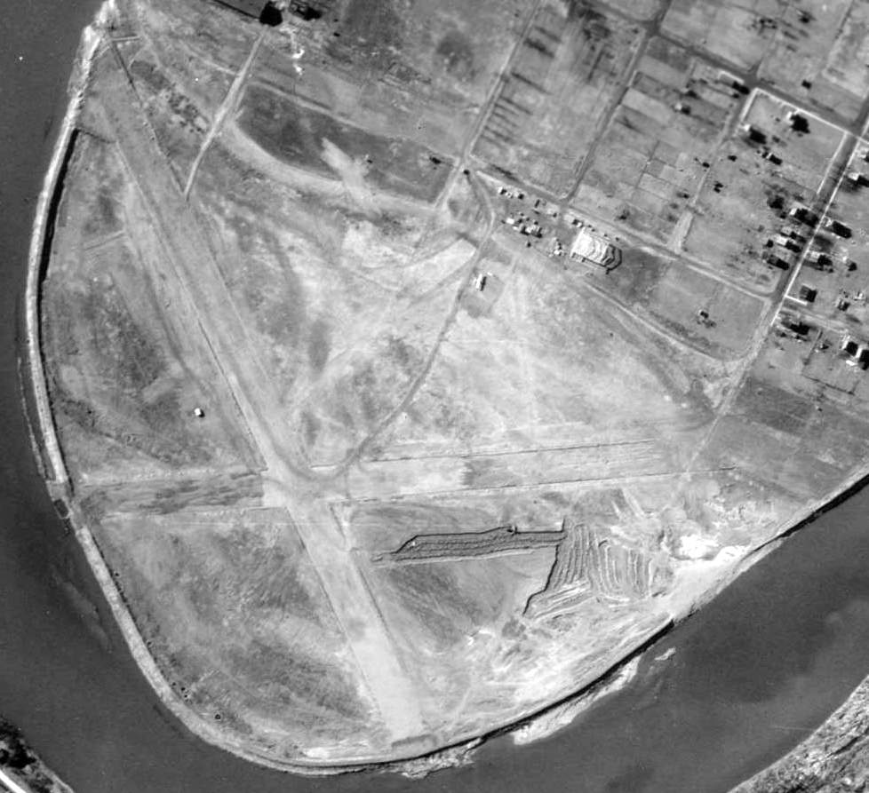
The earliest aerial photo which has been located of Warren Airport was a 3/29/37 aerial view.
It depicted Warren as having 2 unpaved runways, with a hangar on the north side, and one single-engine aircraft on the field.
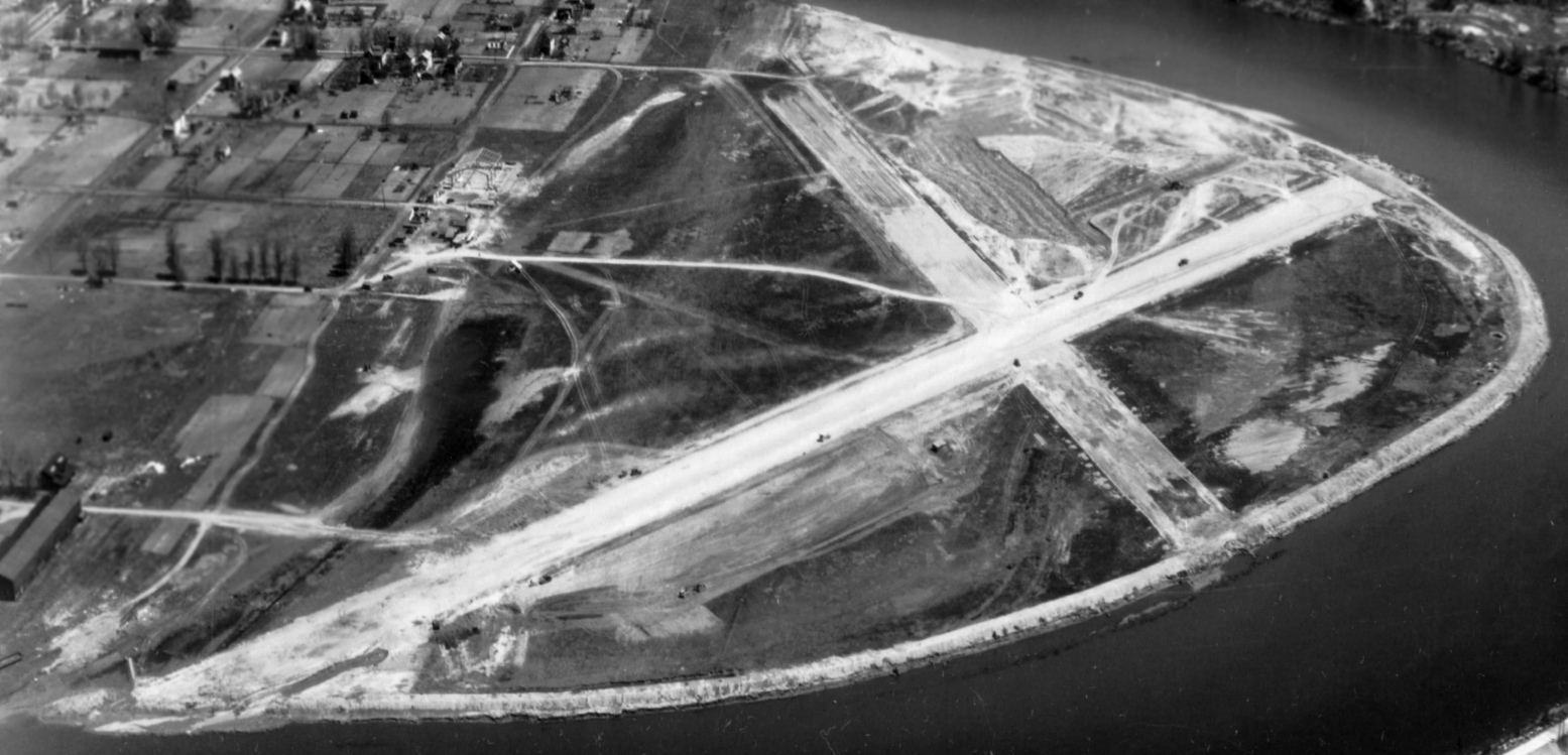
A 5/11/37 aerial view looking east at Warren Airport (from the Dallin Aerial Survey Collection, courtesy of Barbara Hall of the Hagley Museum & Library)
depicted the field as having 2 runways & a small building on the north side, with a larger hangar under construction.
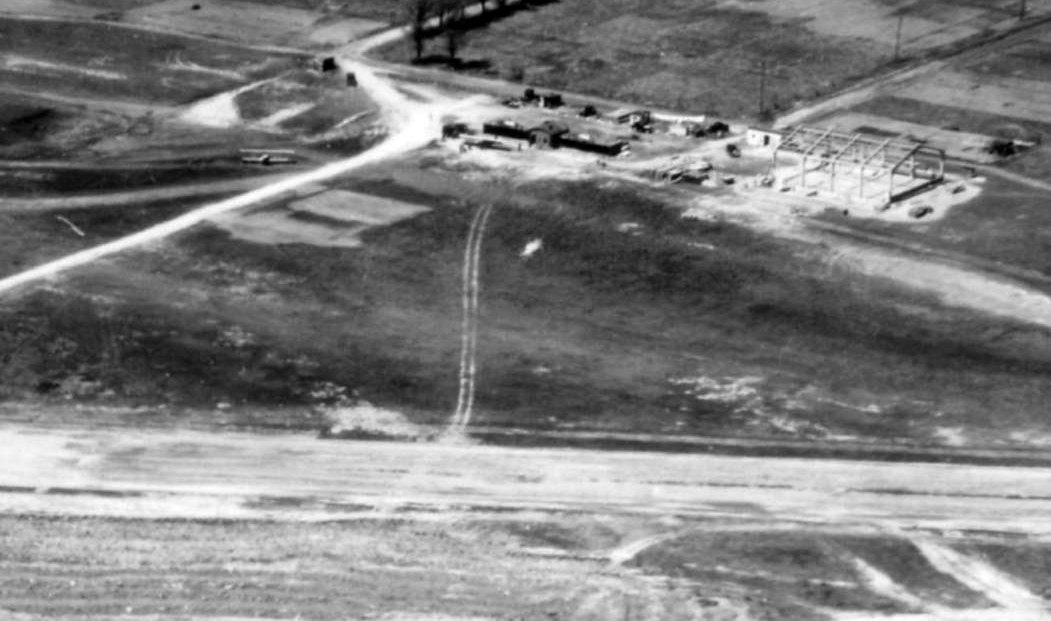
A 5/11/37 aerial view looking north at Warren Airport depicted 2 aircraft parked near a building on the north side of the field,
with another larger hangar under construction.
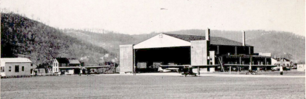
A circa 1930s photo of several aircraft around Warren Airport's hangar (courtesy of Ken Hartley).
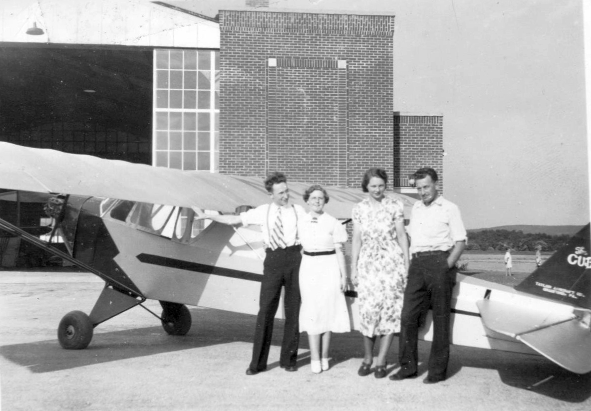
A September 1937 photo (courtesy of Stephen Warburton) of his parents W.E. “Eddie” & Ruby Warburton, and Freda & Marshall “Mushy” Mathis
in front of Mush’s 1935 Taylor Cub (serial #301, registration NC15622) in front of the Warren Airport hangar.
Stephen Warburton reported, “One of my father’s best friends [Marshall 'Mushy' Mathis] was an instructor at Warren Airport during the late 1930s & 1940s.
Even before there was a Civilian Pilot Training Program (CPTP) he was teaching young men to fly from as far away as NE & TX.
He taught my father & continued to teach flying during the war.”
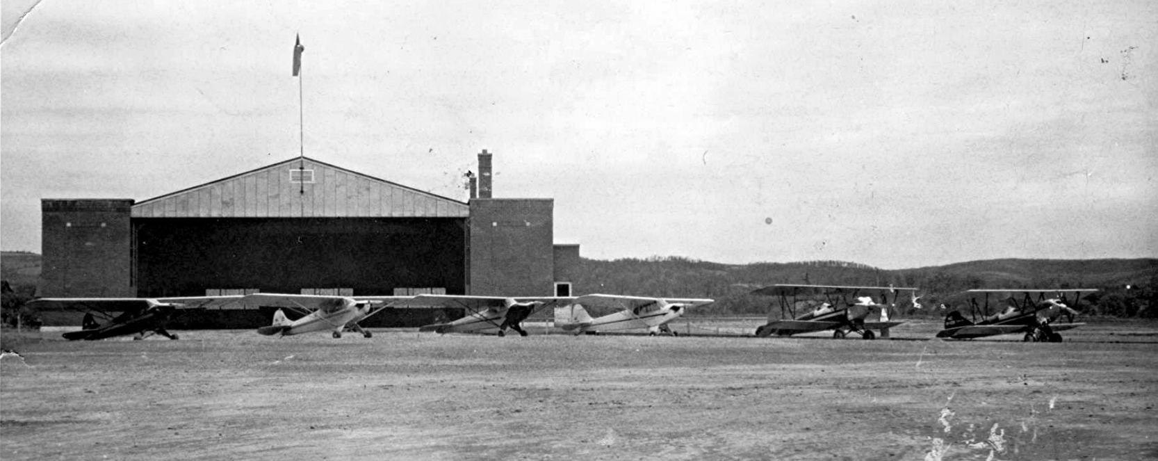
A circa late 1930s photo (courtesy of Stephen Warburton) “of 6 planes lined up in front of what appears to be a very new Warren Airport hangar (Mushy’s plane is 3rd from the left).”
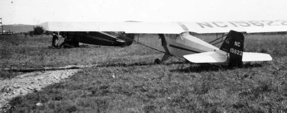
A circa late 1930s photo (courtesy of Stephen Warburton) of Marshall “Mushy” Mathis's 1935 Taylor Cub & another light single-engine taildragger, in the grass possibly at Warren Airport.
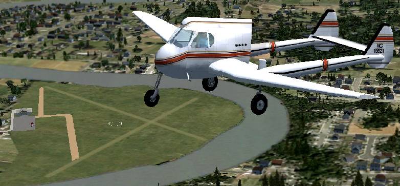
A Flight Simulator scenery re-creation by Richard Finley of a rare & unusual Stearman-Hammond Y1S overflying Warren Airport.
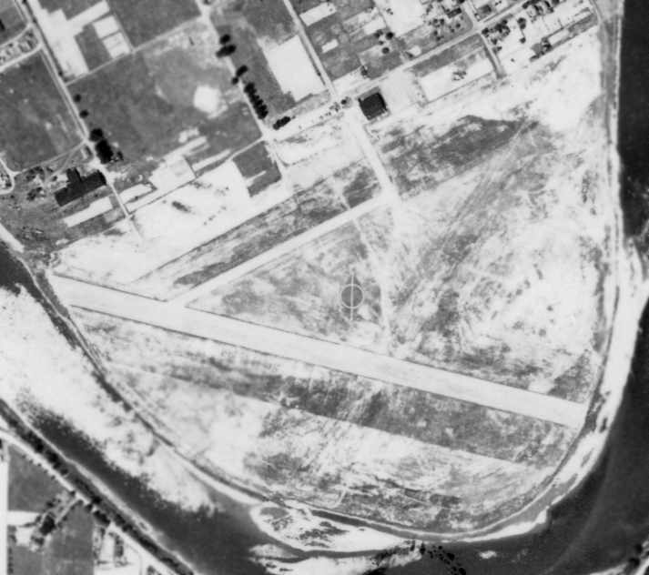
Warren evidently gained a single paved runway at some point between 1937-39,
as a 7/2/39 aerial photo depicted Warren Airport as having a single paved runway, along with a crosswind grass runway.
A hangar was located on the north side of the field.
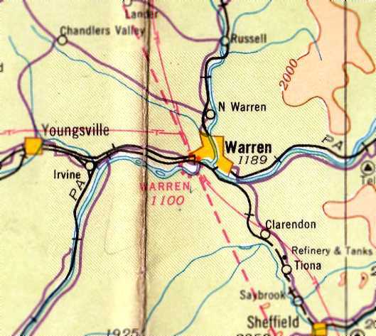
The March 1940 Cleveland Sectional Chart (courtesy of Richard Finley) depicted Warren as a commercial/municipal airport.
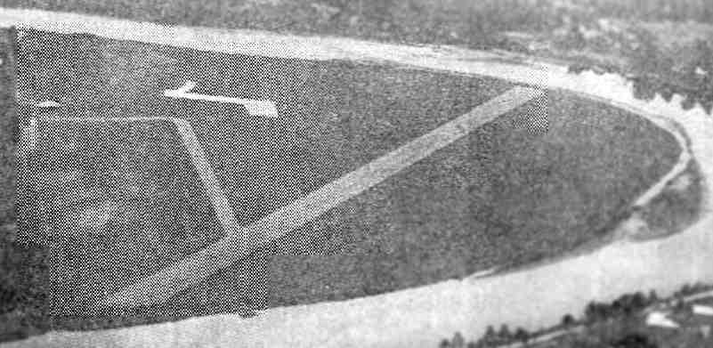
An aerial view looking east at Warren Airport from the Airport Directory Company's 1941 Airport Directory (courtesy of Chris Kennedy).
The field was described as having a single 2,350' "surfaced" runway.
The 1945 AAF Airfield Directory (courtesy of Scott Murdock) described Warren Municipal Airport
as a 77 acre semicircular-shaped property within which was a 2,250' northwest/southeast macadam runway & a 2,10'' northeast/southwest sod runway.
The field was said to have a single 80' x 60' concrete block, steel, and wood hangar.
Warren City Municipal Airport was described as being owned by the City of Warren & operated by private interests.
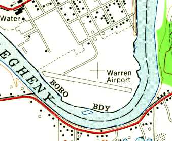
The 1954 USGS topo map depicted Warren as having a single northwest/southeast paved runway.
John Barrett recalled, “I lived my early life in Warren & recall taking a ride from the airport
in a twin-engine craft out over the Kinzua Reservoir & back. Probably 1964 or so.”
The 1967 AOPA Airport Directory (courtesy of Chris Kennedy) described "Warren Municipal"
as having a single 2,200' blacktop Runway 11/29 & a 2,300' sod Runway 6/24.
The field was said to offer fuel & tiedowns, and the operator was listed as the Borough of Warren.
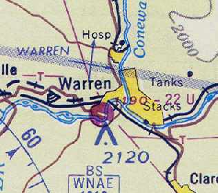
The last aeronautical chart depiction which has been located of Warren Airport
was on the May 1968 Cleveland Sectional Chart (courtesy of Chris Kennedy).
It depicted Warren as having a single 2,200' paved runway.
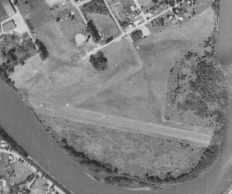
A 9/16/68 aerial photo depicted Warren Airport as having a single paved runway, and a hangar on the north side of the field.
A single light aircraft was visible parked just south of the hangar,
and what appears to be one more aircraft was on the east side of the field, just coming off the runway,
According to Mel Barron, “At one time I leased Warren Airport for a couple of years.
The airport was donated to Warren with the understanding it would always be an airport.
Of course years later the city didn't want the airport & shut it down.”
Warren Airport was evidently closed at some point between 1968-71,
as it was no longer depicted at all on the May 1971 Detroit Sectional Chart (according to Chris Kennedy).
John Barrett reported, “I recall teaching my girlfriend to drive on the old runway in 1971.”
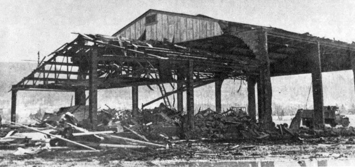
An undated photo from a 3/24/73 newspaper article (courtesy of Lee Corbin), showing the Warren Airport hangar being demolished.
It was captioned, “Workmen began ripping down the old hangar at the airport property on Warren's west side, making way for the long-awaited bypass.”
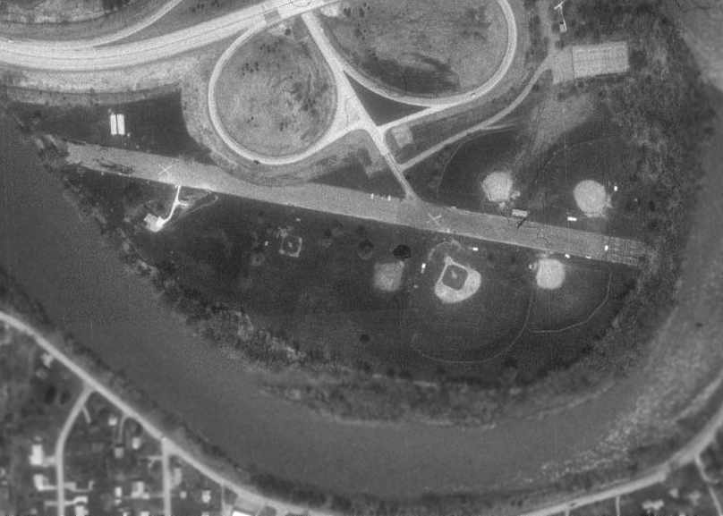
In the 1993 USGS aerial photo, the paved runway at Warren appeared to still remain almost completely intact, with 2 closed-runway "X" symbols still visible.
A cloverleaf for the adjacent Route 6 had been built over a portion of the west end of the runway,
and several baseball diamonds had been built adjacent to the east side of the runway.
According to John Barrett, “The hangar & office were located where Ludlow street exits from the 'clover' & spills onto the runway on the north side of the runway.”
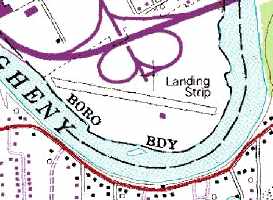
The 1995 USGS topo map still depicted the single runway at the former Warren Airport, but it was labeled simply as "Landing Strip".
The single small building depicted on the south side of the runway was apparently not airport-related, but was apparently a later park-related building.
Nearby resident Mel Barron reported in 2007 that the site of Warren Airport “is now a city park.”
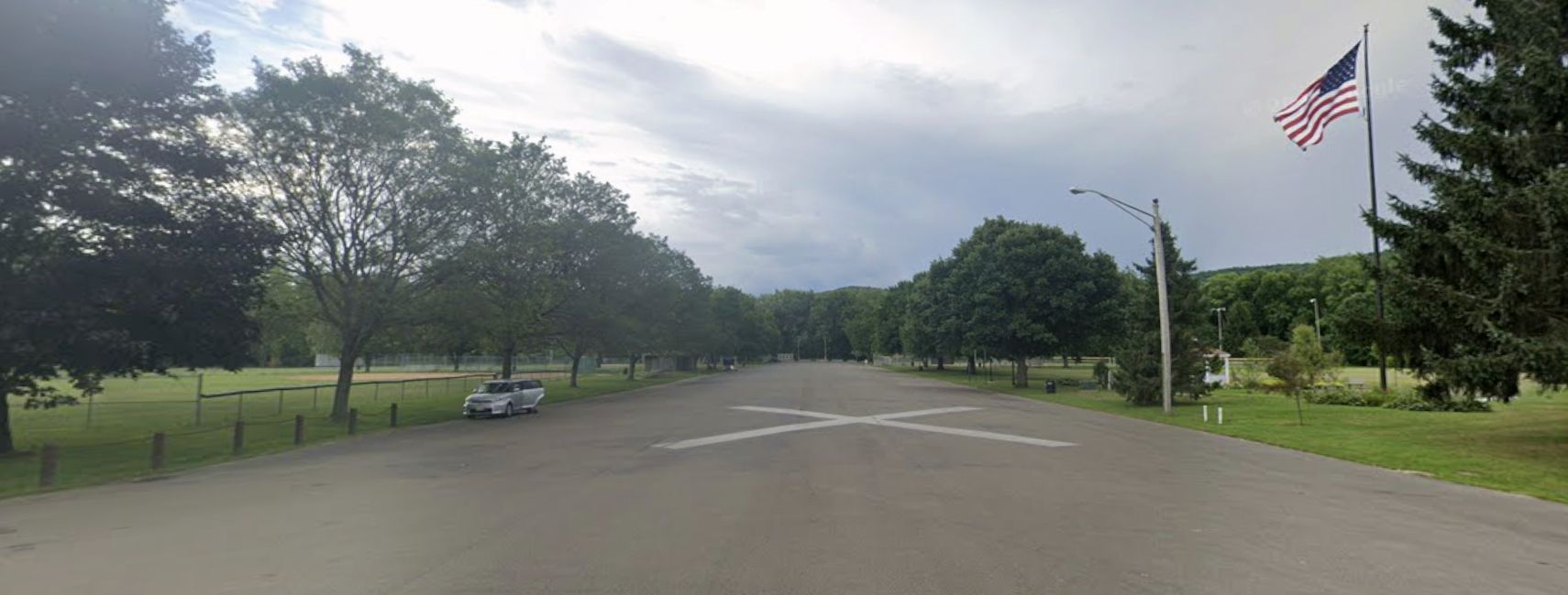
A 2022 photo looking east at the closed-runway “X” symbol which remains on the former Warren Airport runway.
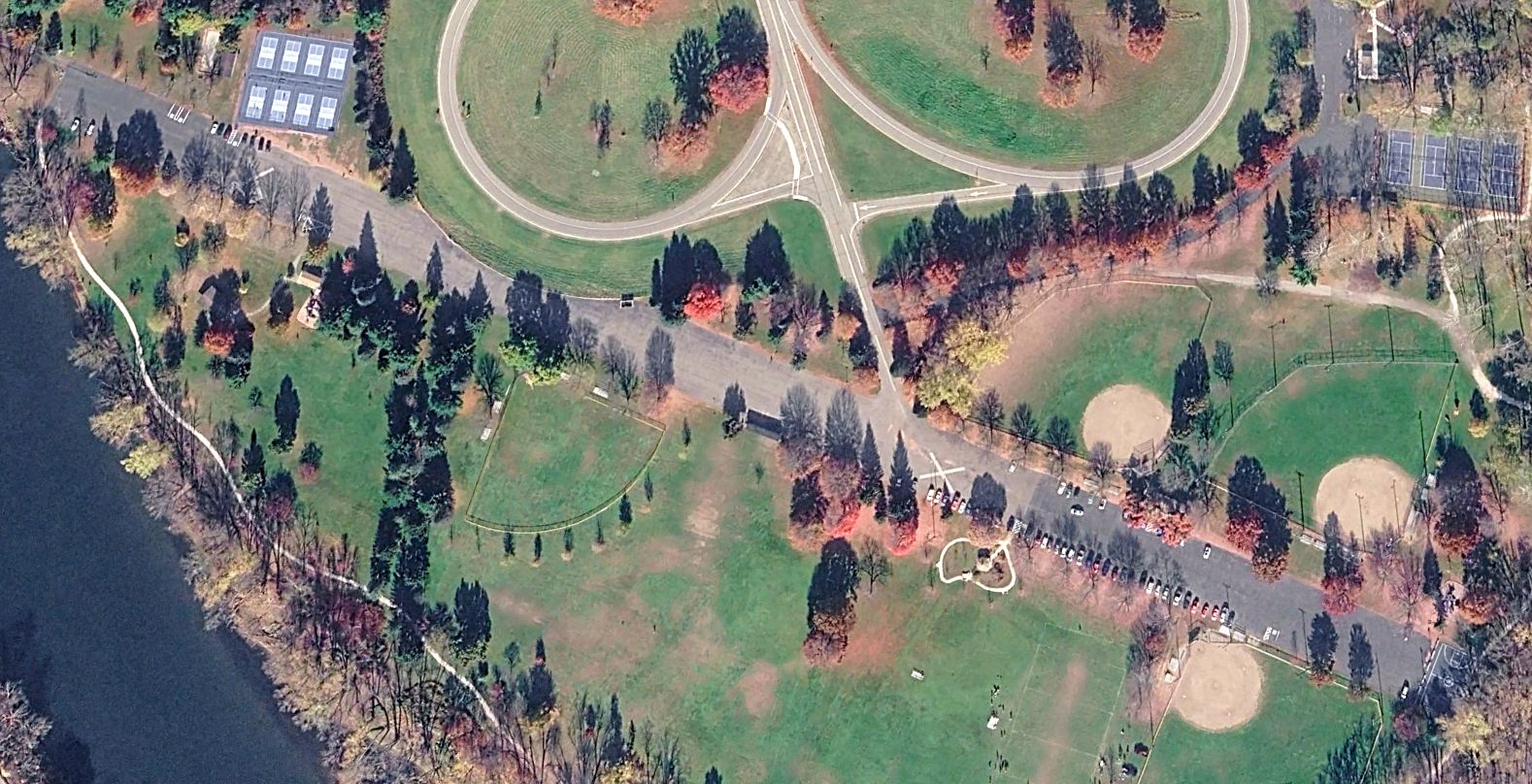
A 2024 aerial view looking northwest showed the 70-year old runway pavement remained in fine shape at the site of Warren Airport.
The site of Warren Airport is located south of the intersection of Route 6 & Ludlow Street.
____________________________________________________
Harri-Emery Field, Bradford, PA
41.94, -78.67 (Northeast of Pittsburgh, PA)
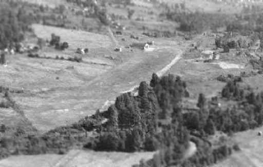
A 1928 aerial view looking north at Harri-Emery Field (courtesy of Ray Lewis).
Harri Emery, an avid pilot, was one of the first to fly an airplane into the city of Bradford in 1919 at the age of 21.
He held the distinction of being the first flying instructor in this section of the country,
and was considered as one of the most competent aviators of his day.
In 1927, Harri & his father William Emery donated a large portion of their family farm for use as an airport.
Following Emery's participation in the national air derby of 1927 (when he finished 5th in the nation),
the future of Bradford in aviation circles seemed certain.
The earliest depiction which has been located of Harri-Emery Field was a 1928 aerial view (courtesy of Ray Lewis).
It depicted the field as a grass strip with a hangar at the northwest end.
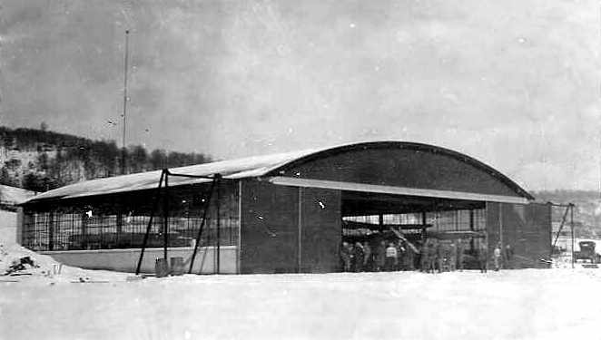
A 1928 photo of the hangar at Harri-Emery Field, with an unidentified biplane visible inside (courtesy of Ray Lewis).
At first, the Harri-Emery Airport was just a landing strip for one airplane,
but by 1929 it boasted a $25,000 hangar (built with money donated by Emery),
and nearly 20 aircraft, with a staff of mechanics, aviators, and repairmen.
The official dedication of the airport was planned for the first week in July 1929, In anticipation of the event, a new runway was added,
trees & railroad tracks were removed, building were painted, and fences constructed.
Many prominent flyers of the day were contacted, including Elinor Smith (holder of the woman's endurance record),
Freddie Lund (ace of the air stuntmen), George Haldeman, Doc Kinkaid,
Earl Rowland, Martin Jensen, Clarence Chamberlain, and all agreed to come.
Three crack Army fliers & three Navy flyers were present,
and it was expected that approximately 115 planes would be at the airport over the 3 day event.
Three air races were planned - one for 0X5 motored planes, the second for light air cooled motors under 200 horsepower,
and the third for motors over 200 horsepower.
The last race of the day would be a free for all, with the course mapped out so that all planes could be seen from the ground at all times.
Sky writing, parachute jumping, aerial acrobatics - all would have a place at the dedication.
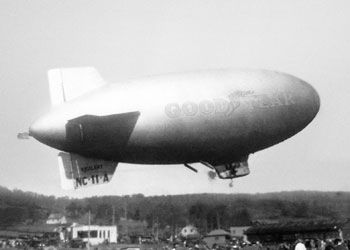
A 1929 photo of a Goodyear blimp visiting Harri-Emery Field, presumably as part of the airport's dedication ceremony.
The day of the dedication dawned & the excitement began.
The Bradford Era wrote "the aeronautical world today bows to Bradford.
For what is said to be one of the largest gatherings of aviation enthusiasts in the East begins here today
and thousands from all part of the country are here to help this community celebrate."
An estimated 30,000 people attended.
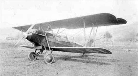
A circa 1929 photo of a Travel Air Model 2000 at Harri-Emery Field.
Following the official dedication program of speeches & awards scheduled for July 6,
the show began, with air races, an aerial parade, and stunt flying.
The next 2 days saw more of the same, each day drawing in huge crowds.
Commander Richard E. Byrd (who was at the south pole at the time) sent a radiogram with greetings to his fellow aviators,
and expressed his congratulations to Bradford on the dedication of its airport.
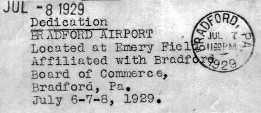
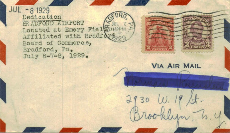
A postmark commemorated the 7/8/29 dedication of “Bradford Airport, located at Emery Field”.
A banquet for more than 250 pilots at the Emery Hotel formally closed the festivities.
Harri Emery & his company, Travel Air, went back to the business of air freight, passengers, lessons, and aerial exhibitions.
Ironically, just 3 months later, on 9/29/1929 Harri Emery was killed while returning from an aerial show & airport dedication in St. Mary's.
His Travelaire plane, lost in fog, came in for an emergency landing too low above the trees, and crashed.
The 9/30/29 issue of the Bradford Era wrote "the first aerial fatality in this county, and one of the worst aviation accidents in this country,
occurred last evening when Lieut. Harri Emery, Bradford's pioneer flyer, and a leading spirit in aviation in this city,
crashed one mile from Kane while piloting his cabin plane, containing 3 passengers, from St. Mary's to Bradford, all of whom were killed."
Within 2 weeks, the new airport, of which Emery was so proud, was renamed in his memory.
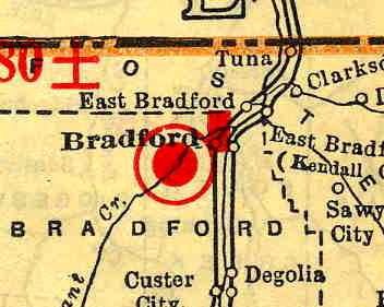
The 1929 Rand McNally "Standard Indexed Map With Air Trails" (courtesy of Chris Kennedy)
described "Bradford Airport" as being operated by the Airport Club of Bradford, and consisting of a 2,100' x 200' field.
Perhaps Emery Field's most lasting claim to fame comes from its brief tenure as the home of the Taylorcraft company.
According to Aerofiles, the Taylor Brothers Aircraft Company (makers of the Taylorcraft) was formed in 1928 at Emery Field in Bradford.
By 1931, a sales slump had forced the bankruptcy of Taylor Brothers,
and the Taylor Aircraft Company (William T. Piper & C. G. Taylor) was formed in Bradford the same year.
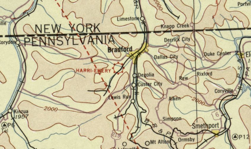
The earliest aeronautical chart depiction which has been located of Harri-Emery Field was on the December 1932 Cleveland Sectional Chart.
It depicted Harri-Emery as a commercial/municipal airport.
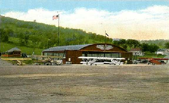
A circa 1930s postcard colorized photo depicting Emery Field (courtesy of Jeff Ferguson).
The 1934 Department of Commerce Airfield Directory (courtesy of Chris Kennedy) described Harri-Emery as having 2 cinder & sod runways,
with the longest being the 2,040' northeast/southwest strip.
A hangar was said to have "Bradford Airport" on the roof, and buildings were said to surround the field.
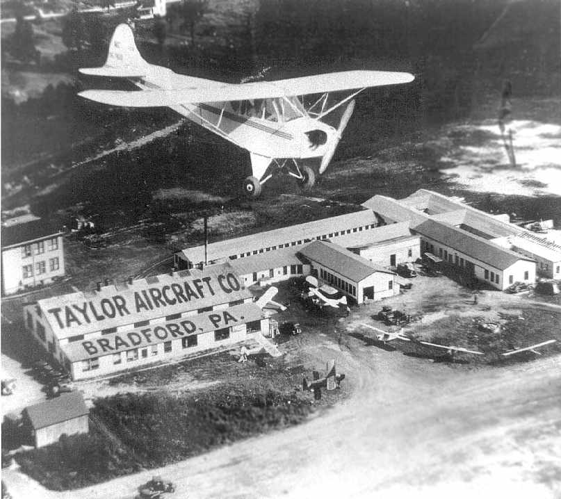
A circa 1936 aerial view of a Taylor J-2 flying over the Taylor Aircraft Company facilities
on the northeast side of Harri-Emery Field in Bradford (courtesy of Ray Lewis).
The Airport Directory Company's 1937 Airports Directory (courtesy of Bob Rambo)
described the Harri-Emery Field as having a 2,040' "cindered" northeast/southwest runway & a 1,585' "hard soil" east/west runway.
A hangar was said to have "Bradford Airport" on the roof, and buildings were said to surround the field.
William Piper bought out C.G. Taylor's interest in the Taylor Aircraft Company during the Great Depression.
In March 1937 the Taylor factory in Bradford burned to the ground, according to Ray Lewis.
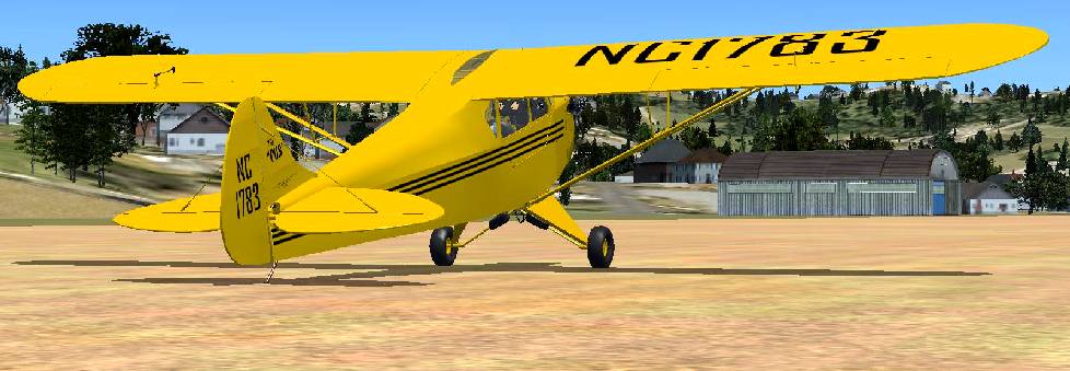
A Flight Simulator scenery re-creation by Richard Finley of a Cub taxiing at Harri-Emery Field.
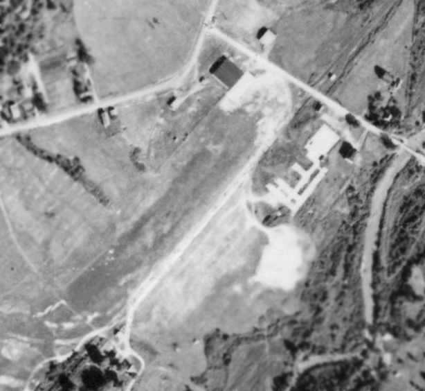
A 9/27/40 aerial photo depicted Harri-Emery Field as having a single northeast/southwest grass runway,
with the 1920s-era hangar on the northwest side of the runway.
The distinctive-shaped outline of the foundation the Taylor Aircraft factory on the northeast side of the runway
can be compared with the building in the 1936 photo.
Piper went on to establish its factory in Lock Haven, PA, and Taylor built a new factory in Alliance, OH by 1941.
Harri-Emery Field was not depicted on the 1941 USGS topo map.
The 1944 US Army/Navy Directory of Airfields (courtesy of Ken Mercer) described Harri-Emery as having a 2,000' unpaved runway.
The 1945 AAF Airfield Directory (courtesy of Scott Murdock) described Harri-Emery Airport
as being extremely small in size – consisting only of a 16 acre irregularly-shaped property
within which was a single 2,040' northeast/southwest sod runway.
The field was said to have hangars, the largest being a 90' x 80' brick & steel structure.
Harri-Emery Airport was described as being owned & operated by private interests.
Ray Lewis recalled, “I learned to fly at Harri-Emery Airport in 1948. Joe Field was my instructor & he ran the airfield.”
The 1957 PA Aeronautical Chart (courtesy of Mike Keefe) described Harri-Emery Field as having a single 2,040' turf northeast/southwest runway.
The operator was listed as the Airport Club of Bradford, Inc., and the manger was listed as Joseph Field.
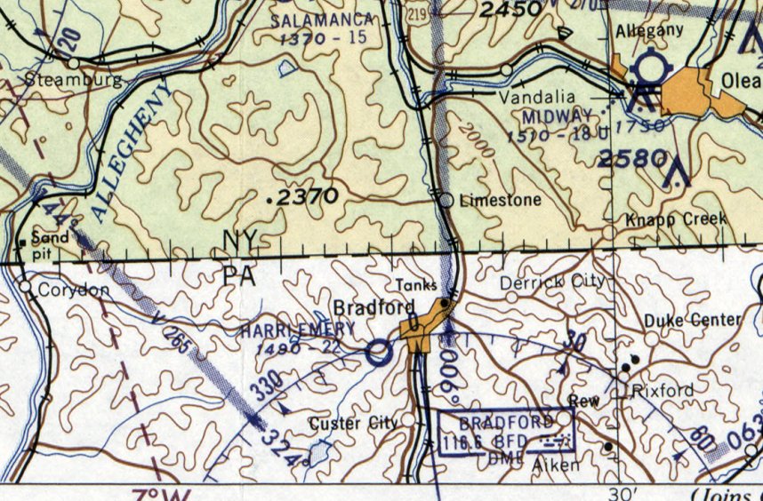
The May 1960 Detroit Sectional Chart depicted Harri-Emery Field as having a 2,200' unpaved runway.
The 1962 AOPA Airport Directory described Harri-Emery as having a single 2,200' turf Runway 4/22, and listed the operator as J. A. Field.
According to the University of Pittsburgh at Bradford's web site,
"On 4/18/67 J.B. Fisher announced that Witco-Kendall Corporation would donate approximately 78 acres of land
on the site of Harri Emery Airport for the construction of a campus."
But the airport evidently continued to operate for another 4 years.
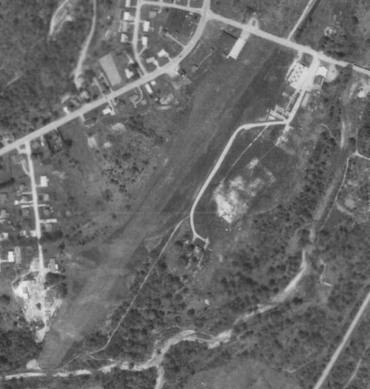
The last photo which has been located of Harri-Emery Field while it was still operational was a 5/25/1968 aerial photo.
It depicted the field as having a single northeast/southwest grass runway,
which appeared to be somewhat longer than was depicted in the 1940 aerial photo.
The 1920s-era hangar remained standing on the northwest side of the runway,
and a checkerboard-roofed building had been constructed over the northern portion of the site
of the former Taylor Aircraft factory on the northeast side of the runway.
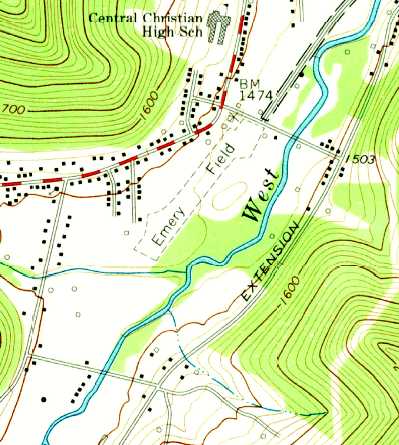
The 1969 USGS topo map depicted “Emery Field” as having a single unpaved northeast/southwest runway,
with a few small buildings arrayed along both sides of the northeast end of the runway.
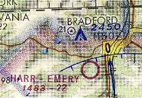
The last aeronautical chart depiction which has been located of Harri-Emery Field
was on the May 1971 Detroit Sectional Chart (courtesy of Chris Kennedy).
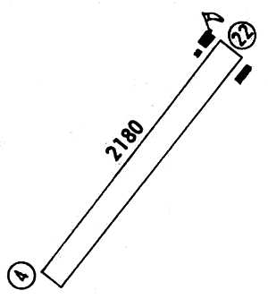
The 1971 Flight Guide (courtesy of Chris Kennedy) depicted Harri-Emery Field as having a single 2,180' Runway 4/22,
with 3 small buildings (hangars?) arrayed along both sides of the northeast end of the runway.
Harri- Emery Field closed in 1971, according to Ray Lewis.
Harri-Emery Field was no longer depicted on the November 1972 Detroit Sectional Chart (courtesy of Ron Plante).
The 1977 USGS topo map showed that the site of Harri-Emery Field had become the campus of the new University of Pittsburgh at Bradford.
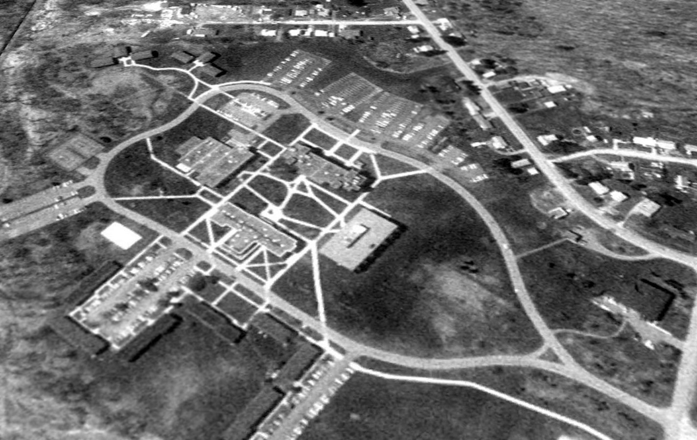
A 1993 USGS aerial view looking west showed the University of Pittsburgh at Bradford covered the site of Harri-Emery Field, but the former hangar remained at the bottom-right.
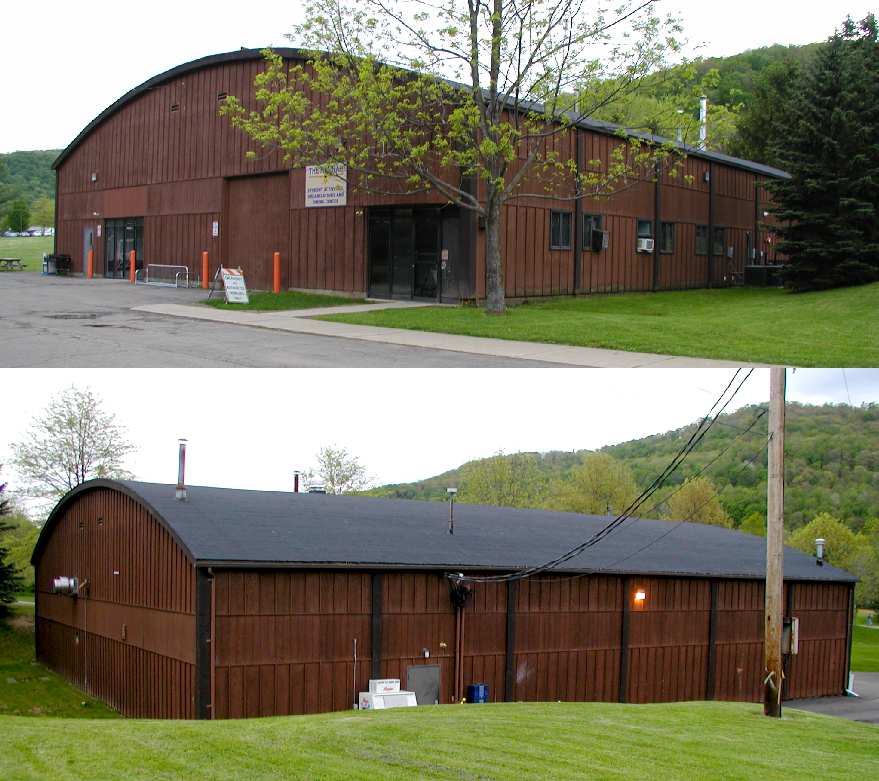
Two 2003 photos by Dan Rhinehart of the circa 1928 Harri-Emery hangar, the only former airport structure which remains at the site.
It is currently reused as "The Hangar", a student activity center.
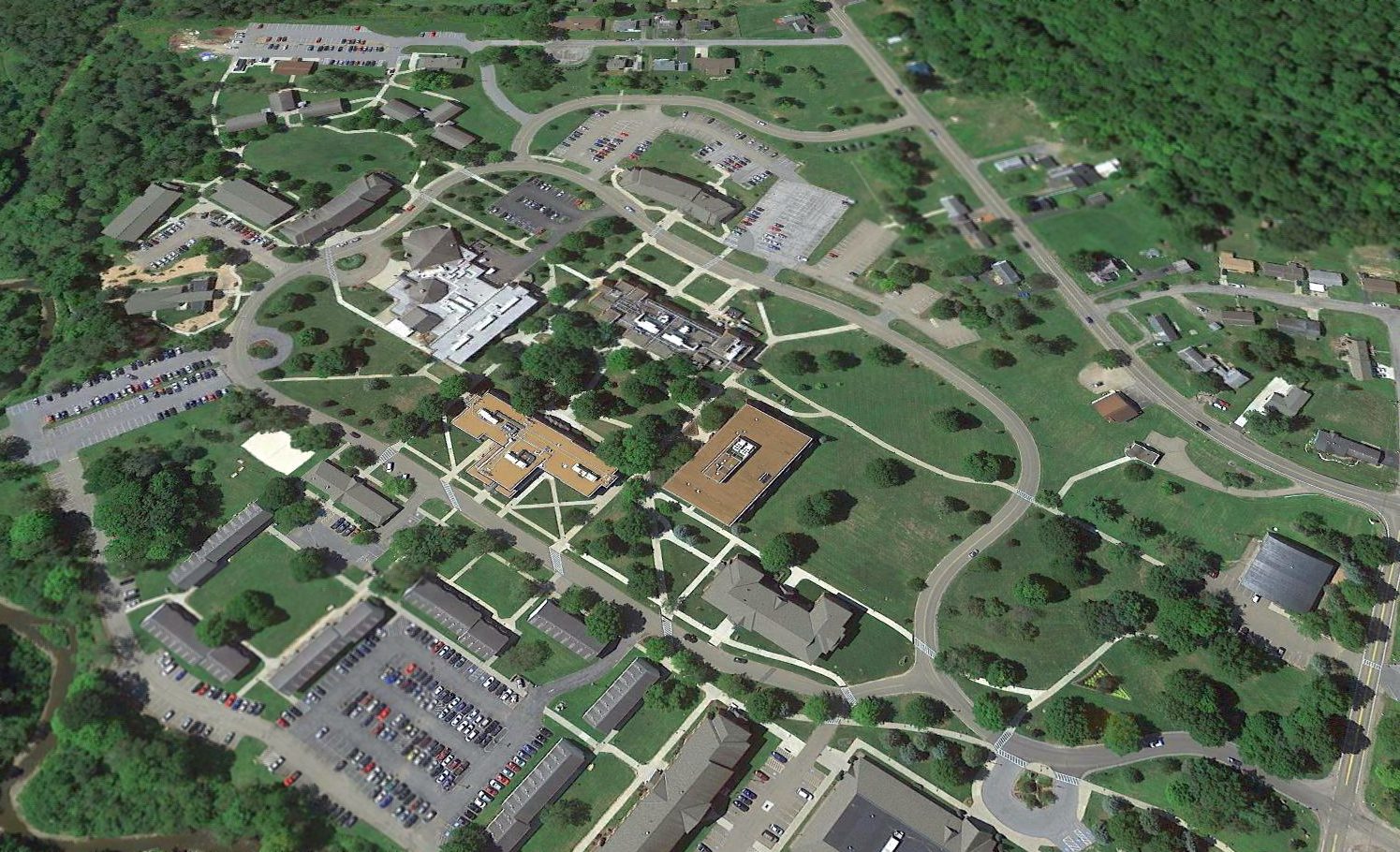
A 2016 aerial view looking west at the site of Harri-Emery Field, with the former hangar at the bottom-right.
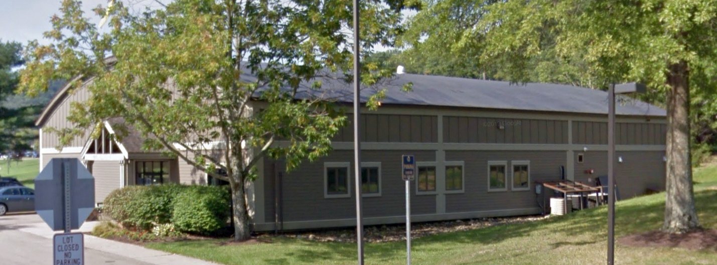
A circa 2015-2019 photo (courtesy of Sam Berliner) of the circa 1928 Harri-Emery hangar, showing that it has been significantly revamped since 2003.
The site of Harri-Emery Field is located southeast of the intersection of Route 346 & Taylor Drive (appropriately enough).
See also: http://www.bradfordlandmark.org/capsules/dedication_of_the_bradford_airport.html
____________________________________________________
Or if you prefer to contact me directly concerning a contribution (for a mailing address to send a check),
please contact me at: paulandterryfreeman@gmail.com
If you enjoy this web site, please support it with a financial contribution.
____________________________________________________
This site covers airfields in all 50 states.