Abandoned & Little-Known Airfields:
Northwestern Pennsylvania
© 2002, © 2026 by Paul Freeman. Revised 2/5/26.
This site covers airfields in all 50 states: Click here for the site's main menu.
____________________________________________________
Please consider a financial contribution to support the continued growth & operation of this site.
Benninger Airport (revised 1/23/24) - Brookville Airport (revised 2/5/26) - Original Dubois Airport / Dubois City Airport (revised 6/14/20) - (Original) Grove City Airport (revised 10/2/17)
Mercer Airport / Intermediate Field Site 39 (revised 5/24/19) - Mount Jewett Airport (revised 11/17/21) - Oil City Glider Club Gliderport / Splane Memorial Field (revised 3/9/19)
Rhea Airport (revised 1/23/24) - Seneca Airpark (revised 2/5/26) - Sharon Airport (revised 3/24/23)
____________________________________________________
41.242, -79.426 (Northeast of Pittsburgh, PA)
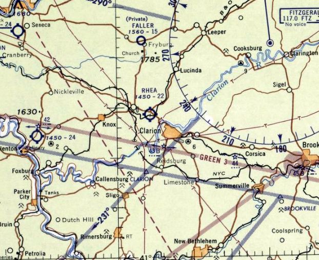
Rhea Airport, as depicted on the July 1956 Cleveland Sectional Chart.
According to the Clarion County Airport website, “During the decades after the war [WW2] the county would see its second airport.
For the public scene aviation would shift to the privately-owned Rhea Airport (also called Rhea’s Field)
located at the intersection of State Route 66 & US 322 (across from the current Country Fair Market & Gas Station).
Rhea Airport opened in 1954.
This new airfield gained a commercial license in the early 1950s shortly after its completion & replaced Parker Cramer Airport as the county’s public face of aviation.”
Rhea Airport was not yet depicted on the December 1955 Cleveland Sectional Chart.
The earliest depiction which has been located of Rhea Airport was on the July 1956 Cleveland Sectional Chart.
It depicted Rhea as having a 2,200' unpaved runway.
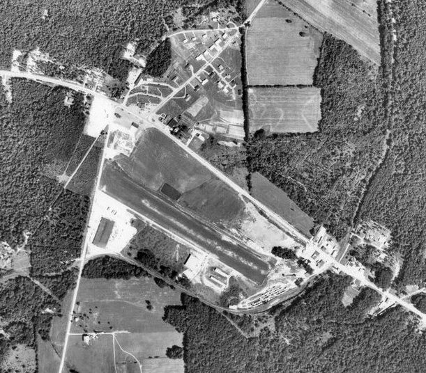
The earliest photo which has been located of Rhea Airport was a 1950s aerial view (courtesy of Harrison Fox).
It depicted a single unpaved northwest/southeast runway, with a few small buildings at the northwest end.
Aerial photos from 1966 & 1968 depicted Rhea Airport as having a single unpaved northwest/southeast runway, with 2 light single-engine planes at the northwest end.
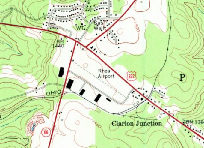
The 1969 USGS topo map depicted Rhea Airport as having a single unpaved northwest/southeast runway, with a few small buildings at the northwest end.
According to the Clarion County Airport website, “Due to planned construction on US Route 322 & plans to further develop the area with such attractions as a strip shopping mall,
Rhea Airfield had to be abandoned & planning began on the current facility.”
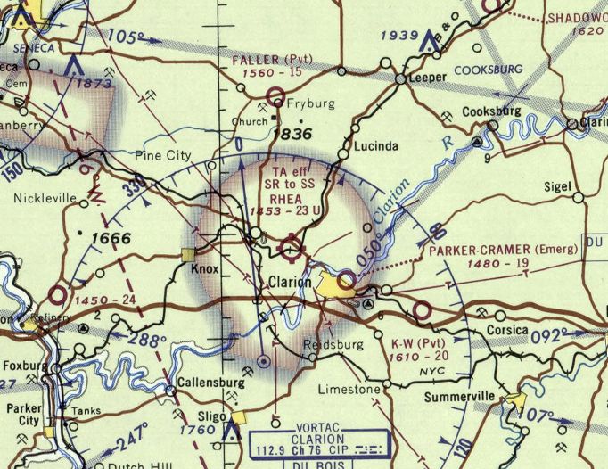
The last aeronautical chart depiction which has been located of Rhea Airport was on the November 1969 Cleveland Sectional Chart.
It depicted Rhea as having a 2,300' unpaved runway.
Rhea Airport was no longer depicted on the May 1970 Cleveland Sectional Chart.
A 1981 aerial photo showed the site of Rhea Airport had been covered with several buildings.
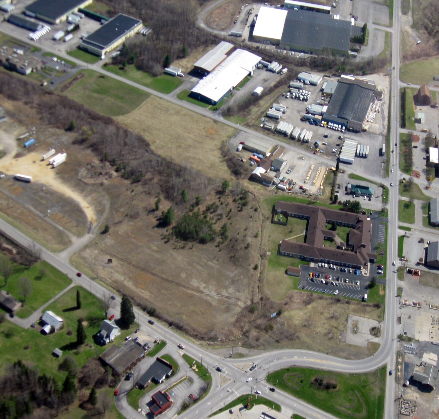
A 2014 aerial view looking south (courtesy of Harrison Fox) showed no trace remaining of Rhea Airport.
Thanks to Harrison Fox for pointing out this airport.
____________________________________________________
41.221, -80.451 (Northwest of Pittsburgh, PA)
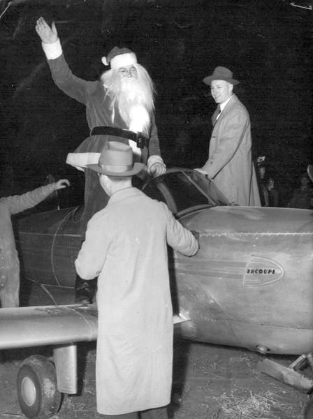
Santa Claus standing on an Ercoupe at Sharon Airport in 1948.
According to the article “Sharon Airport aided travelers” in the 7/4/00 Sharon Herald (courtesy of John Yurkon),
“A small airfield was located off Christy Road a few miles southeast of Sharon.
Known as the Sharon Airport, it was also called Chadderton Airport for Edward Chadderton, who operated an over-the-road transportation company,
but also used the field for charter flights, shipping air cargo, and flight instruction.
Chadderton acquired the airfield in 1946, paving & extending the main runway to 3,200'; adding 2 grass airstrips;
building an office, large hangar & 10 T-hangars for small planes, and installing ground lights for night operations.
His air cargo operations used twin-engine Beechcrafts & Cessnas piloted by Robert Blatz & Joe Buckwalter, who doubled as flight instructors.”
The article “Special delivery: Scrapbook tells story of Santa's 1948 arrival by plane” in the 11/27/15 Sharon Herald (courtesy of John Yurkon)
described a visit by Santa Claus to Sharon Airport, an event attended by a large number of spectators.
The earliest depiction which has been located of Sharon Airport was a photo of Santa's 1948 visit.
Sharon Airport was not yet depicted on the January 1949 Cleveland Sectional Chart.
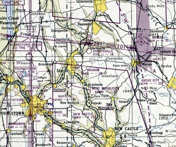
The earliest aeronautical chart depiction which has been located of Sharon Airport was on the December 1949 Cleveland Sectional Chart.
It depicted Sharon Airport as having a 2,400' unpaved runway.
A 1950 aerial view showed Sharon Airport to have 3 grass runways,
with 1 light single-engine aircraft & a few small hangars on the northwest & northeast sides.
A 1951 aerial view showed Sharon Airport in an unchanged configuration.
A 1955 aerial view showed Sharon Airport had gained a north/south paved runway at some point between 1951-55.
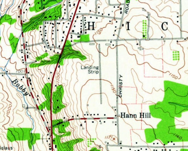
The earliest topo map depiction which has been located of Sharon Airport was on the 1958 USGS topo map.
It depicted Sharon Airport as having a single paved north/south runway, labeled generically as “Landing Strip”, with a few small buildings on the northwest & northeast sides.
According to John Yurkon, “I grew up near Sharon. I flew a few times at Sharon Airport.
It was a nice paved runway with lighting. I rented a Cessna 150.”
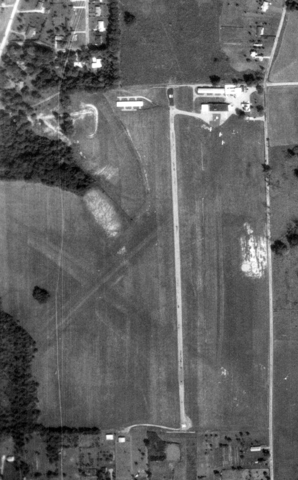
The only aerial photo which is available showing aircraft at Sharon Airport was a 9/8/68 USGS aerial view.
It depicted Sharon Airport as having a single paved north/south runway & 2 grass crosswind runways,
with 3 light single-engine aircraft & several small hangars on the northwest & northeast sides.
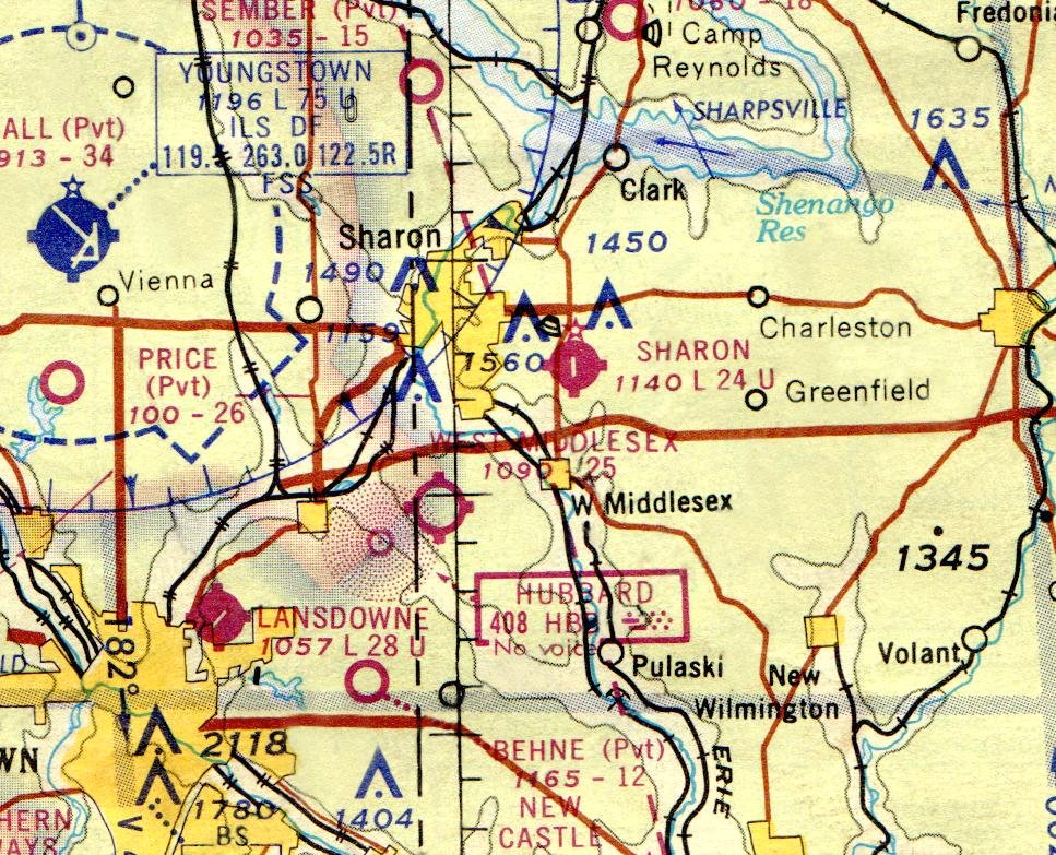
The November 1968 Detroit Sectional Chart depicted Sharon Airport as having a single paved 2,400' north/south runway.
The last photo which has been located showing aircraft at Sharon Airport was a 1970 aerial view,
which showed 5 light single-engine aircraft on the field.
The 1971 USGS topo map still depicted Sharon Airport as a generically labeled “Landing Strip”.
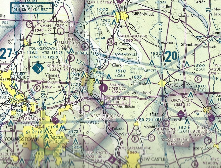
The last aeronautical chart depiction which has been located of Sharon Airport was on the 1977 Detroit Sectional Chart (courtesy of John Yurkon).
It depicted Sharon Airport as having a single paved 2,300' north/south runway.
Sharon Airport was evidently closed (for reasons unknown) at some point between 1977-81,
as it was labeled “Sharon Airport (Closed)” on the May 1981 Detroit Sectional Chart.
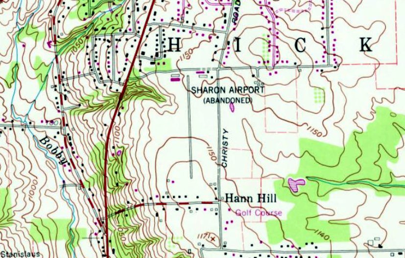
“Sharon Airport (Abandoned)”, as depicted on the 1981 USGS topo map.
A 1983 aerial photo showed Sharon Airport's runways & hangars remaining intact, but there were no aircraft visible on the field.
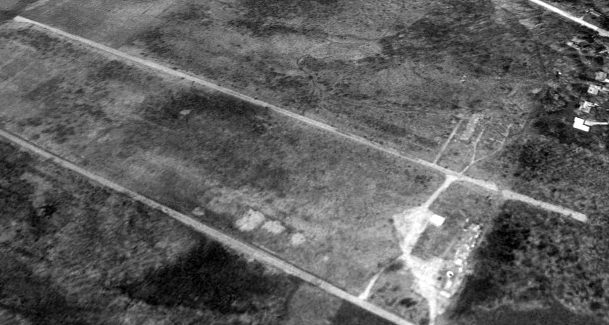
A 1993 USGS aerial view looking southwest showed Sharon Airport's runways remaining intact, but the hangars had been removed at some point between 1983-93.
A 2004 aerial photo showed a road (Innovation Way) having been constructed over the Sharon Airport site,
but the southern portion of the paved north/south runway remained recognizable.
The 2013 USGS topo map no longer depicted Sharon Airport, but instead showing Innovation Way on the airport site.
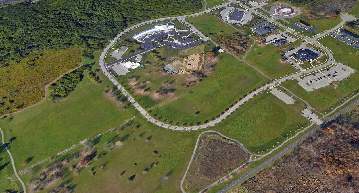
A 2016 aerial view looking northwest showed the LindenPointe business campus covering the majority of the Sharon Airport site,
but the southern portion of the paved north/south runway remained recognizable (at bottom-left).
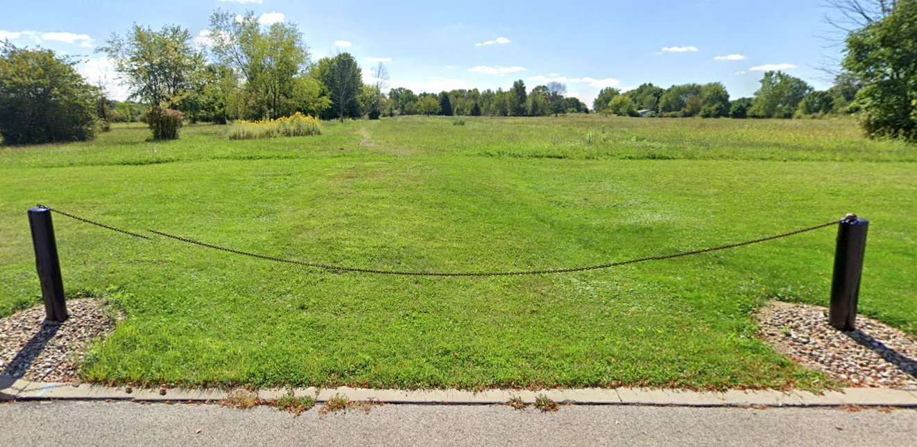
A September 2019 photo looking south showed only the faintest trace remaining of the southern portion of the Sharon Airport runway.
Thanks to John Yurkon for pointing out this airport.
____________________________________________________
41.38, -79.72 (Northeast of Pittsburgh, PA)
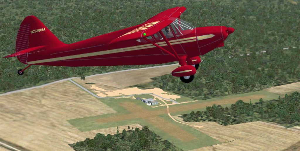
A Flight Simulator scenery re-creation of Seneca Airpark by Richard Finley,
looking southeast at a light aircraft overflying the field.
Seneca Airpark was not yet depicted on a 7/2/39 aerial view nor on the March 1940 Cleveland Sectional Chart.
According to Richard Finley, “Seneca Airpark: Located in Seneca, a suburb of Oil City, this airport primarily served the Oil City area.
It was opened in the late 1940s as a 2 grass runway commercial airport with a Fixed-Base Operator.”
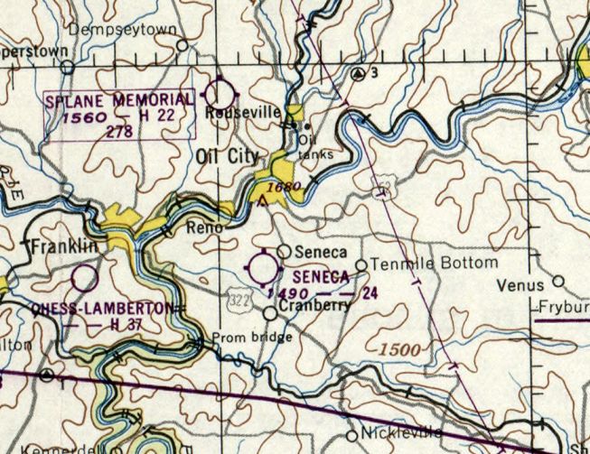
The earliest aeronautical chart depiction which has been located of Seneca Airpark was on the November 1950 Cleveland Sectional Chart.
It depicted Seneca Airpark as having a 2,400' unpaved runway.
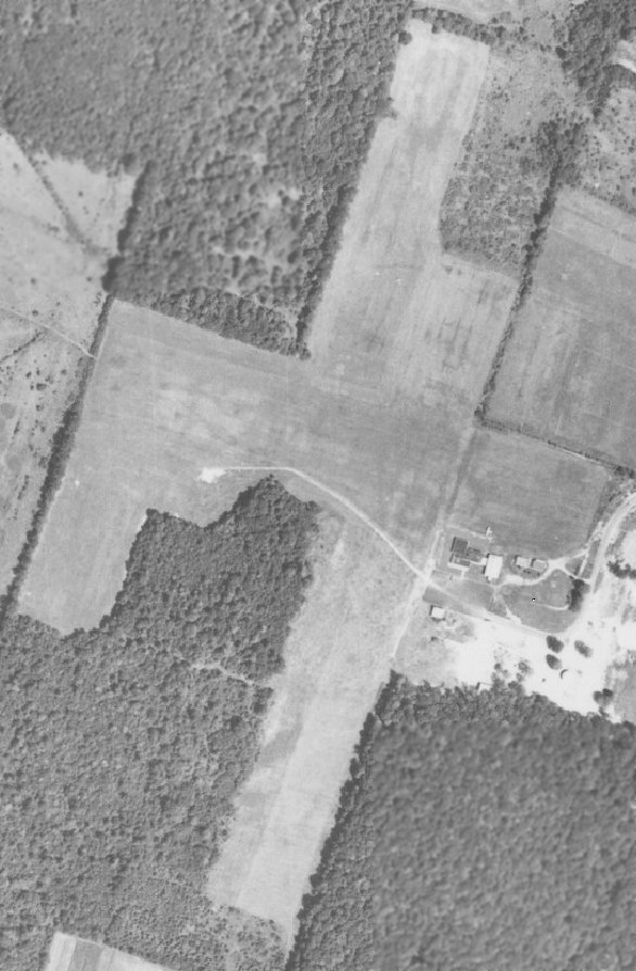
The only photo which has been located of aircraft at Seneca Airpark was an 8/27/58 aerial view.
It depicted Seneca Airpark as having 2 grass runways with several small buildings & one single-engine aircraft on the east side.
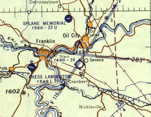
The last aeronautical chart depiction which has been located of the 1st iteration of Seneca Airpark was on the July 1960 Cleveland Sectional Chart.
It depicted Seneca Airpark as having a 2,400' unpaved runway.
Seneca Airpark was evidently closed at some point between 1960-65,
as it was no longer depicted on the May 1965 Cleveland Sectional Chart.
The 1965 USGS topo map depicted the runway clearing & the airport buildings, but did not label the airport.
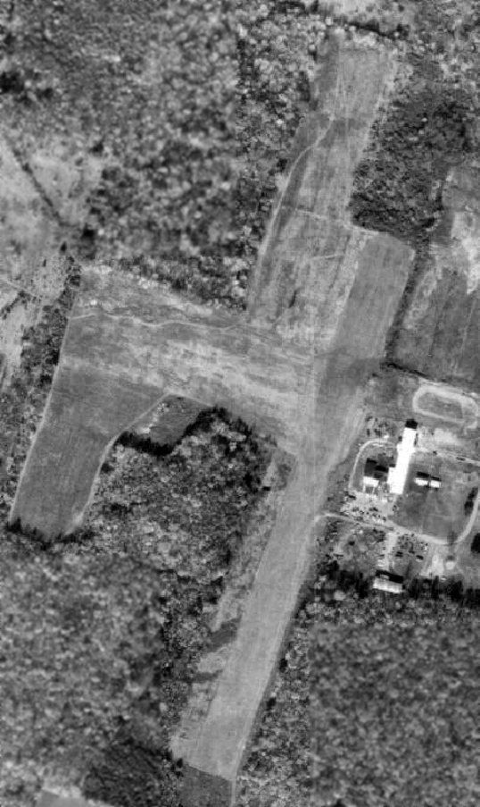
A 10/30/68 aerial view depicted Seneca Airpark as having 2 grass runways with several small buildings on the east side.
Seneca Airpark was not depicted on the November 1968 Cleveland Sectional Chart or the May 1970 Cleveland Sectional Chart.
According to Richard Finley, Seneca Airpark “was reborn in the 1970s when the owner sold part of the east/west runway for a housing development,
paved the north/south runway & reopened it as an aircraft home base with no Fixed-Base Operator.”
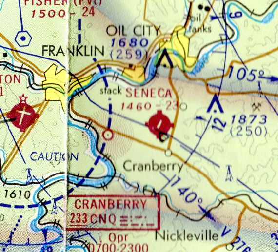
The earliest aeronautical chart depiction which has been located of the 2nd iteration of Seneca Airpark
was on the November 1972 Detroit Sectional Chart (courtesy of Richard Finley).
It depicted Seneca Airpark as having a 2,300' paved northeast/southwest runway.
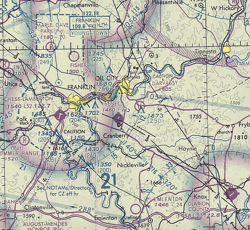
The last aeronautical chart depiction which has been located of the 2nd iteration of Seneca Airpark
was on the May 1981 Detroit Sectional Chart (courtesy of Ron Plante).
It depicted Seneca Airpark as having a single 2,200' paved northeast/southwest runway.
According to Richard Finley, “In the late 1980s or early 1990s, it [Seneca Airpark] was closed again.”
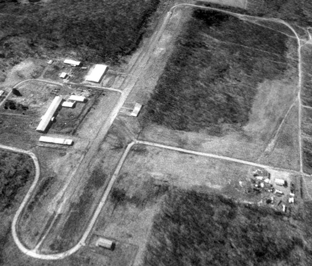
A 4/10/93 aerial view looking south depicted Seneca Airpark as having a single north/south paved runway.
The airport buildings remained, but there were no planes or other signs of aviation usage.
Seneca Airpark was evidently closed (for the 2nd time) at some point between 1981-93,
as it was no longer depicted on the October 1993 Detroit Sectional Chart (courtesy of Ron Plante).
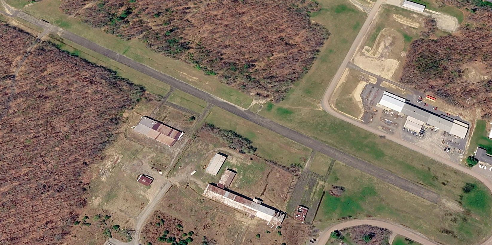
A 2025 aerial view looking southwest showed the Seneca Airpark paved runway to remain in fine shape. What a shame for this fine little facility to go unused for aviation.
Richard Finley reported in 2016 of Seneca Airpark, “The runway is still there.”
Seneca Airpark is located at the western terminus of Airport Road, appropriately enough.
Thanks to Ken Hartley for pointing out this airport.
____________________________________________________
Original Dubois Airport / Dubois City Airport, Dubois, PA
41.11, -78.73 (Northeast of Pittsburgh, PA)
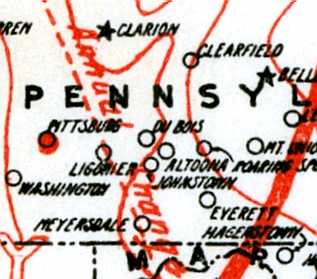
The original Dubois Airport, as depicted on the 1920 Army Air Service Map of U.S. Landing Fields (courtesy of David Brooks).
The original airport for the town of Dubois was located on the southeast side of the town, adjacent to the Oklahoma neighborhood.
The date of establishment of the original Dubois Airport has not been determined.
The earliest depiction which has been located of Dubois Airport was on the 1920 Army Air Service Map of U.S. Landing Fields (courtesy of David Brooks).
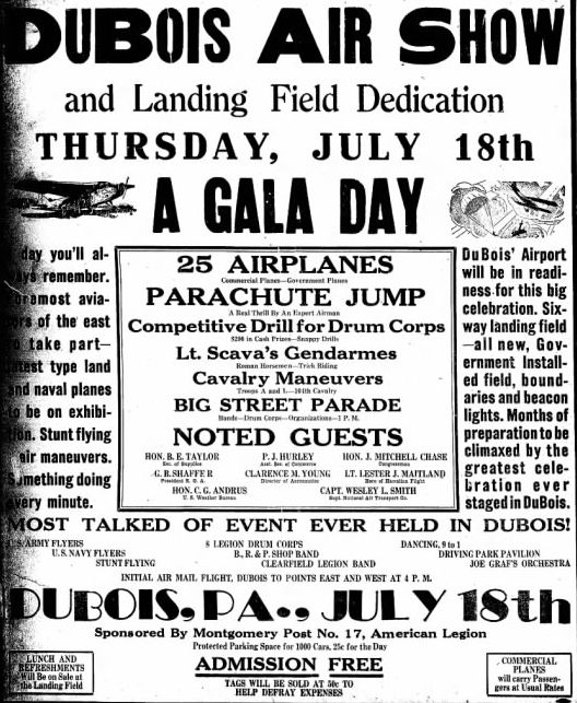
An advertisement for the 7/18/29 “DuBois Air Show & Landing Field Dedication” from the 7/16/16 DuBois Courier Express (courtesy of Gary Clyde).
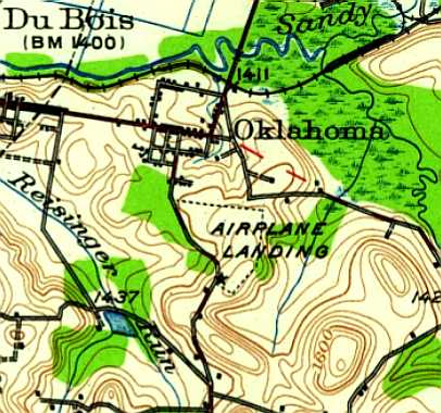
The 1929 USGS topo map depicted the original Dubois Airport as an irregularly-shaped “Airplane Landing” area.
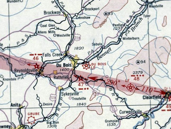
The earliest aeronautical chart depiction which has been located of Dubois Airport was on the December 1932 Cleveland Sectional Chart.
It depicted Dubois as a commercial/municipal airport.
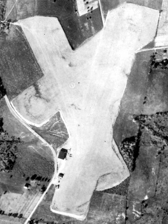
The earliest photo which has been located of Dubois Airport was a 10/7/39 aerial photo (from the Pennsylvania Geological Survey).
It depicted Dubois as having 3 grass runways, with an airport circle marking in the center.
Two light planes were visible parked around the cluster of 3 small hangars on the southwest side.
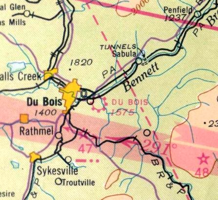
The March 1940 Cleveland Sectional Chart (courtesy of Richard Finley) depicted Dubois Airport as a commercial/municipal airport.
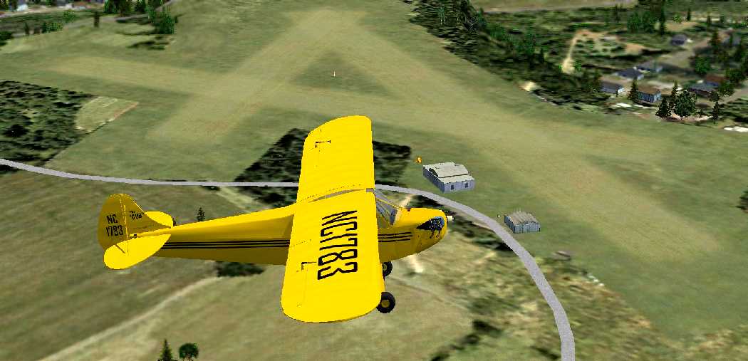
A Flight Simulator scenery re-creation of the original Dubois Airport by Richard Finley,
looking northwest at a Piper J-3 Cub overflying the field.
Clarence Krach recalled, “My father operated the original [Dubois] Airport through the war years until it closed.
I flew out of the airport in the 1950s.”
According to Wikipedia, “In the early 1950s the City of DuBois created a Municipal Airport Authority
which looked into means of expanding the existing DuBois City Airport, in the Oklahoma section, east of the city.
They determined that site was unsuitable for further expansion,
and joined with Jefferson County officials to procure” a replacement airport site 6 miles northwest of DuBois.
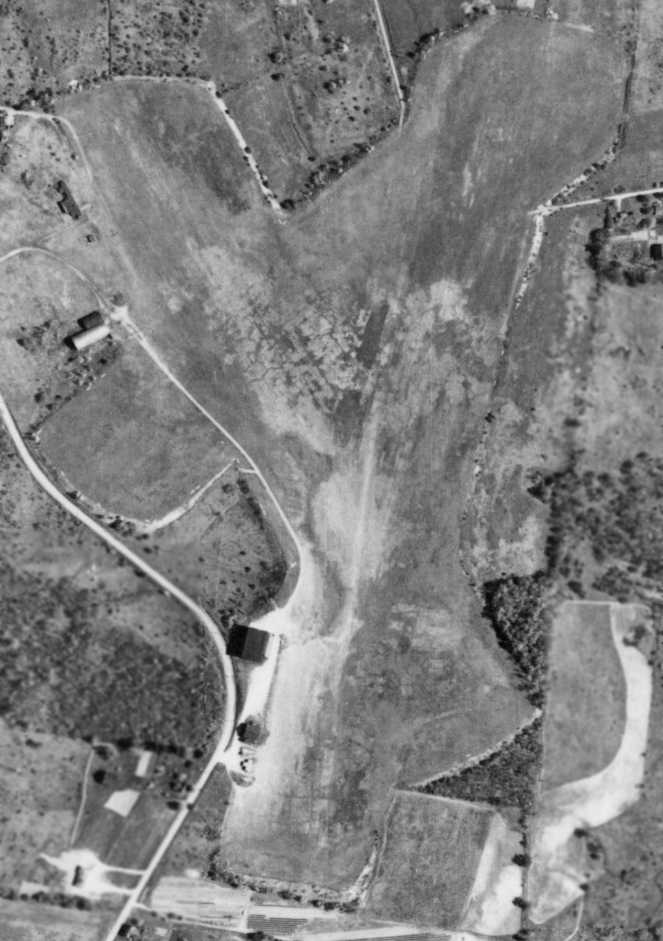
The last photo which has been located showing Dubois Airport still intact was a 5/13/58 aerial photo (from the Pennsylvania Geological Survey).
The 3 grass runways were still intact, along with the 3 hangars at the southwest side,
but the airport circle marking in the center was gone, and there were no aircraft visible on the field.
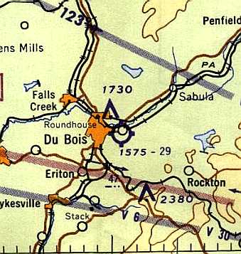
The last aeronautical chart depiction which has been located of Dubois Airport was on the 1960 Cleveland Sectional Chart.
It depicted Dubois as a public-use airport having a 2,900' unpaved runway.
According to Wikipedia, the new Dubois Regional Airport conducted its first flight on 6/1/60,
at which point presumably the original Dubois Airport was closed.
The original Dubois Airport was no longer depicted on the 1968 Cleveland Sectional Chart.
A 10/1/68 aerial photo (from the Pennsylvania Geological Survey) showed that a large building (a school?)
had been built over the site of the hangars at some point between 1958-68.
The outline of the runways remained mostly intact.
The 1993 USGS aerial photo showed that several buildings had been constructed over the northwestern portion of the airport site,
but the northeastern runway portion remained clear.
A 2005 aerial photo showed that ballfields had been constructed over the northeast portion,
covering the last portion of the original Dubois Airport.
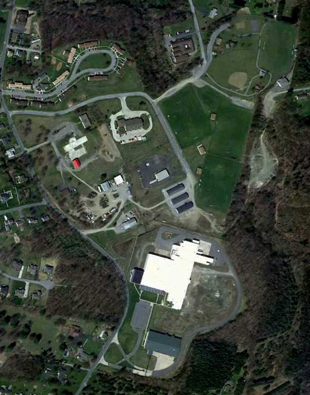
A 4/12/12 aerial view showed the outline of the northeast portion of the Dubois Airport was the last recognizable trace of the airport.
The site of the original Dubois Airport is located east of the intersection of Oklahoma Salem & William Penn Avenue.
____________________________________________________
Benninger Airport, Tionesta, PA
41.46, -79.44 (Northeast of Pittsburgh, PA)
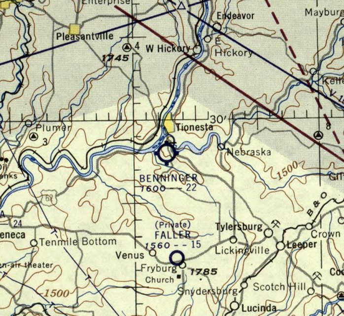
Benninger Airport, as depicted on the January 1955 Cleveland Sectional Chart.
This small airport was evidently established at some point between 1953-55,
as it was not depicted on a 7/3/39 aerial photo (from the Pennsylvania Geological Survey)
nor on the June 1953 Cleveland Sectional Chart (courtesy of Ron Plante).
The earliest depiction which has been located of Benninger Airport was on the January 1955 Cleveland Sectional Chart.
It depicted Benninger as having a 2,200' unpaved runway.
Benninger Airport was not depicted on the 1958 USGS topo map.
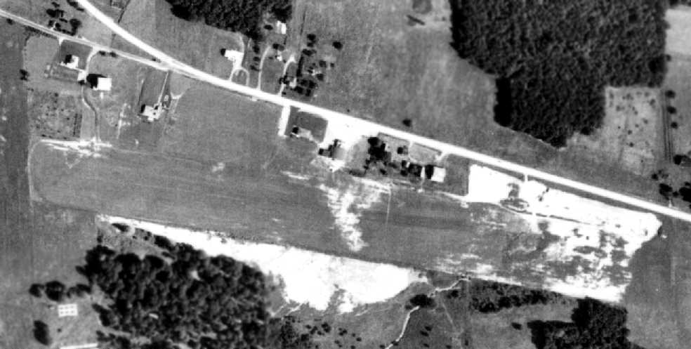
The earliest photo which has been located of Benninger Airport was on an 8/28/58 aerial photo (from the Pennsylvania Geological Survey).
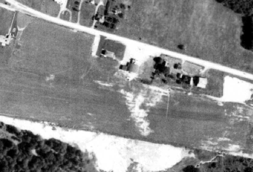
A closeup on the north side of Benninger Airport from the 8/28/58 aerial photo (from the Pennsylvania Geological Survey).
According to Richard Finley, “This airport was built behind a restaurant with an aviation theme.
It had a PT-19 on the roof which you can see in the 1958 aerial photo.”
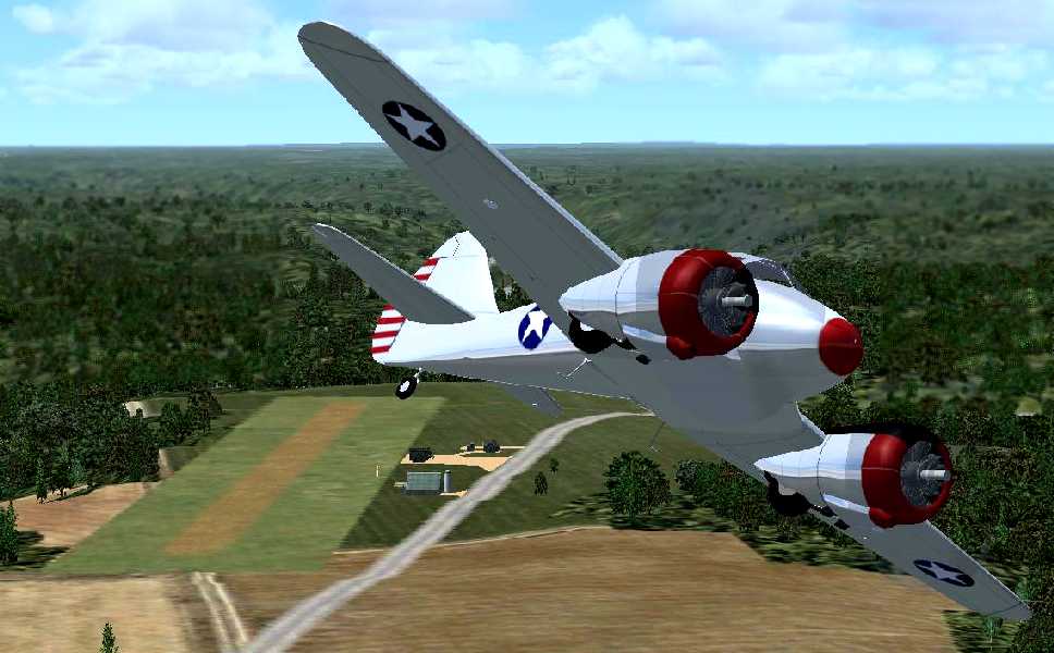
A Flight Simulator scenery re-creation of Benninger Airport by Richard Finley,
looking west at a Curtiss AT-9 Jeep overflying the field.
Benninger Airport was mentioned in various articles in the Titusville Herald from 1962-69.
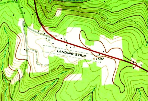
The 1967 USGS topo map depicted Benninger Airport as a single unpaved northwest/southeast runway,
labeled simply as “Landing Strip”, with a few small buildings along the north side.
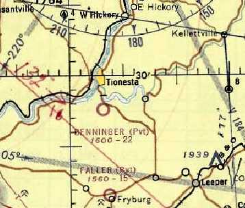
The last aeronautical chart depiction which has been located of Benninger Airport
was on the May 1968 Cleveland Sectional Chart (courtesy of Ron Plante).
It depicted Benninger as a private airfield with a 2,200' unpaved runway.
A 1968 aerial view of Benninger Airport still showed the PT-19 mounted on the roof of the restaurant.
Benninger Airport was evidently closed (for reasons unknown) at some point between 1968-70,
as it was no longer depicted on the May 1970 Cleveland Sectional Chart.
The 1973 USGS topo map continued to depict the Benninger Airport “Landing Strip” in an unchanged fashion.
A 1981 aerial photo showed the Benninger runway remained clear, but there was no sign of any recent aviation activity.
The airport restaurant building remained intact, but the PT-19 had been removed from its roof at some point between 1958-93.
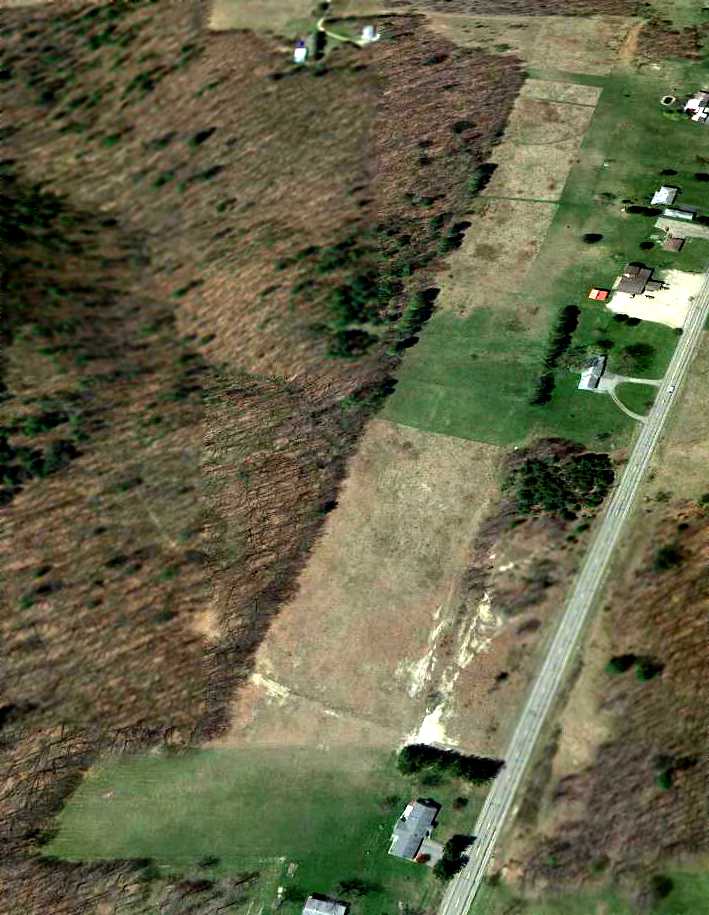
A 4/12/12 aerial view looking west showed the Benninger runway remained clear,
and the airport restaurant building remained intact, but without its roof-mounted airplane.
As of 2013, the former Benninger Airport restaurant continues to operate with an aviation theme, as the “Sky Jet Restaurant”.
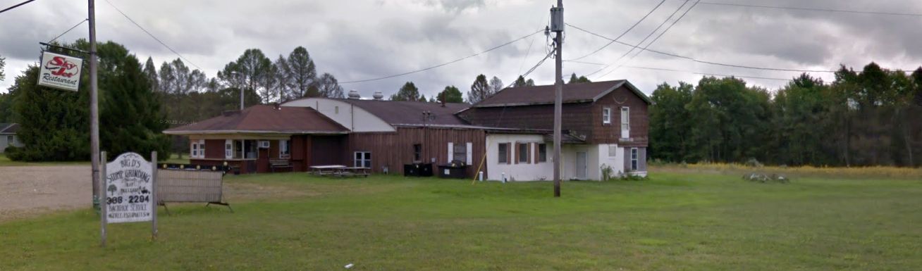
A 2018 photo looking southeast at the former Benninger Airport hangar & restaurant, with the “Sky Jet Restaurant” sign in front.
The site of Benninger Airport is located southeast of the intersection of Route 36 & Route 3006.
____________________________________________________
Mount Jewett Airport, Mount Jewett, PA
41.72, -78.62 (Northeast of Pittsburgh, PA)
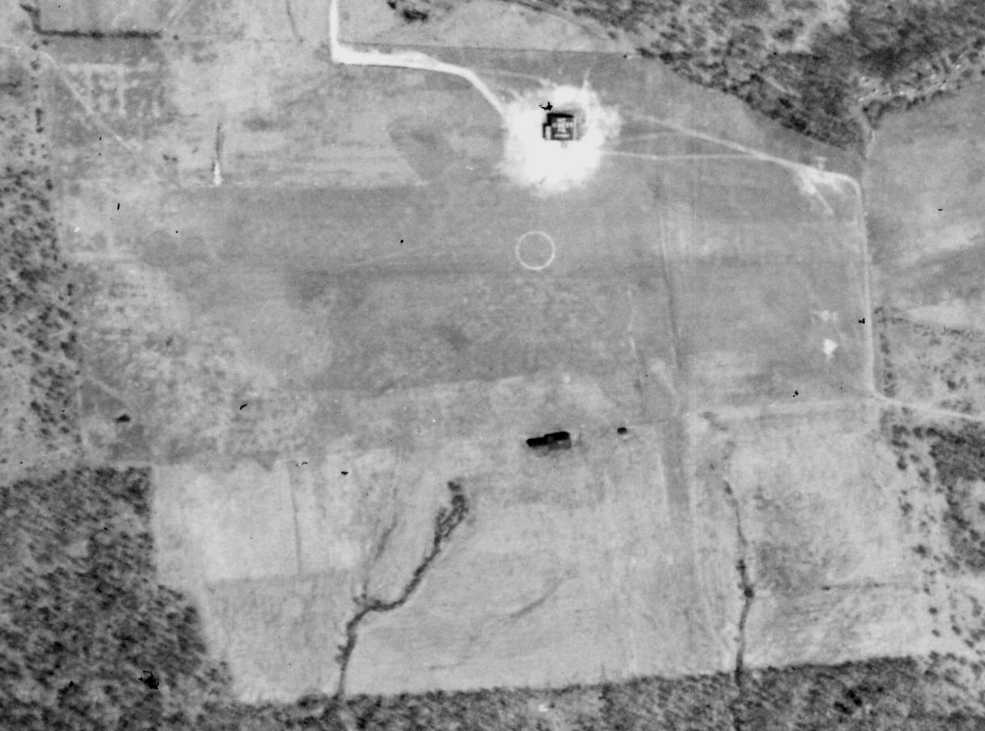
Mount Jewett Airport, as depicted on a 4/25/41 aerial photo (from the Pennsylvania Geological Survey, courtesy of James Line).
Mount Jewett Airport was not yet depicted on the 1920 Army Air Service Map of U.S. Landing Fields (courtesy of David Brooks)
nor listed in The Airport Directory Company's 1937 Airports Directory (courtesy of Bob Rambo).
An article entitled “R. Kessler Heads Mt. Jewett Airport” in the 10/7/37 issue of the McKean County Democrat (courtesy of Jim Line)
explained that a hangar needed to be built in order to secure a “permanent Airport License”.
In an article entitled “WPA Plans for Jewett Airport” in the 1/27/38 McKean County Democrat (courtesy of Jim Line),
those associated with the airport declared itself as "one of the best airports in this area."
The article called for an "airport enlargement" including 2 runways, 500' in width, the "North South" runway being 3,400' in length,
which would surpass the length of the original runway, which was only 2,900' long.
An article entitled “Prepare plans for hangar at Mt. Jewett Airport” in the 5/12/38 McKean County Democrat (courtesy of Jim Line) said,
“A number of the Mt. Jewett Airport Association members met & were shown plans of hangars by G.A. Rogers,
a representative of Plaw-Knox Corp. of Pittsburgh.
Plans are under way for the erection of a 70' x 100' hangar, with stalls for 5 ships.
The probable location will be in the northwest corner of the airport.
The hangar will be of steel construction. Grading of the grounds is progressing very nicely.”
Jim line observed, “The hangar was placed in the northeast corner of the airport, not the northwest as originally planned.
It was a rather large airport, capable of handling 2 crosswind runways.
The road leading into this airstrip (which is situated on top of a hill) is Snowdome Road.
The only reason Snowdome Road in Mount Jewett exists was to foster travel to the old airport.”
Mount Jewett Airport was not depicted on the March 1940 Cleveland Sectional Chart nor on the 1940 USGS topo map.
The earliest depiction which has been located of Mount Jewett Airport
was a 4/25/41 aerial photo (from the Pennsylvania Geological Survey, courtesy of James Line).
James Line observed, “Pennsylvania Highway 6 runs east to west to the north of the airport, parallel with the main East/West runway.
There is a clear hangar [which appeared to have lettering on the roof], and a circle in the center of the runway.
If you look close, there is a large 'X' for crosswind runways,
and possibly a North/South strip that is on the eastern 1/4 of the runway, with the southern end stopping near another building.”
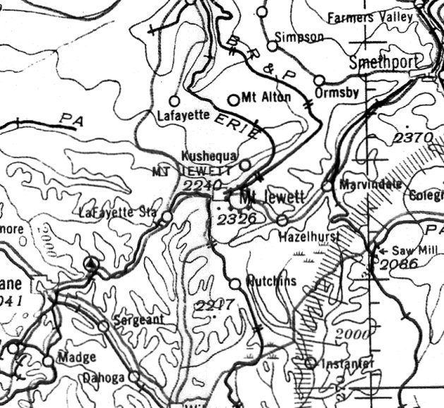
The earliest aeronautical chart depiction which has been located of Mount Jewett Airport was on the June 1941 Cleveland Sectional Chart (courtesy of Ron Plante).
It depicted Mount Jewett as a commercial/municipal airport.
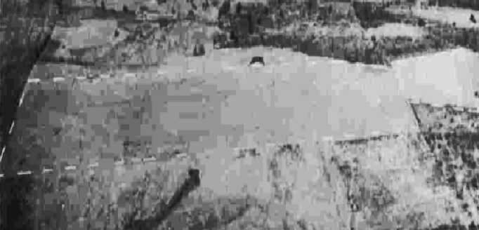
A 10/20/43 aerial view looking north from the 1945 AAF Airfield Directory (courtesy of Scott Murdock)
depicted Mount Jewett Airport as an east/west unpaved field with a single hangar on the north side.
The 1945 AAF Airfield Directory (courtesy of Scott Murdock) described Mount Jewett Airport
as a 50 acre irregularly-shaped property having 3 sod runways, the longest being a 1,900' east/west strip.
The field was said to have a single 60' square wood & metal hangar,
to be owned by the Borough of Mount Jewett, and to be operated by private interests.
Mount Jewett Airport was not depicted on the 1946 or 1955 USGS topo maps.
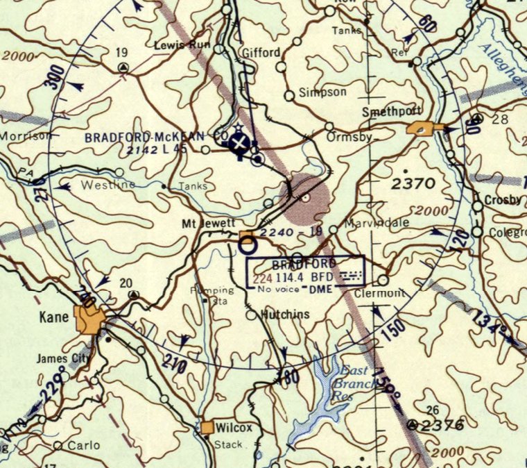
The last aeronautical chart depiction which has been located of Mount Jewett Airport was on the December 1955 Cleveland Sectional Chart.
It depicted Mount Jewett as having a mere 1,900' unpaved runway.
Mount Jewett Airport was evidently closed (for reasons unknown) at some point between 1955-56,
as it was no longer depicted on the July 1956 Cleveland Sectional Chart.
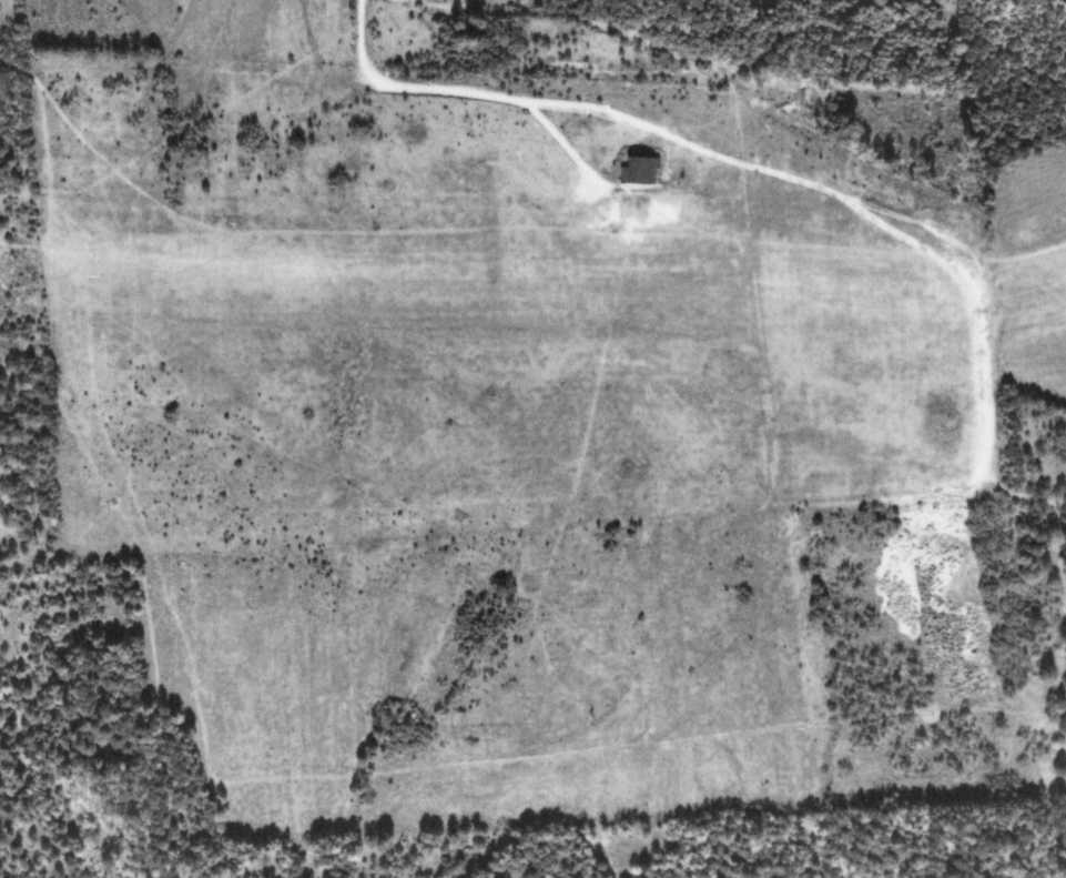
A 10/2/58 aerial photo (courtesy of the Pennsylvania Geological Survey) still depicted Mt. Jewett Airport as remaining intact,
but the field was evidently abandoned by that point, as the airport circle marking was gone, along with the lettering on the hangar roof.
There was no sign of any current usage.
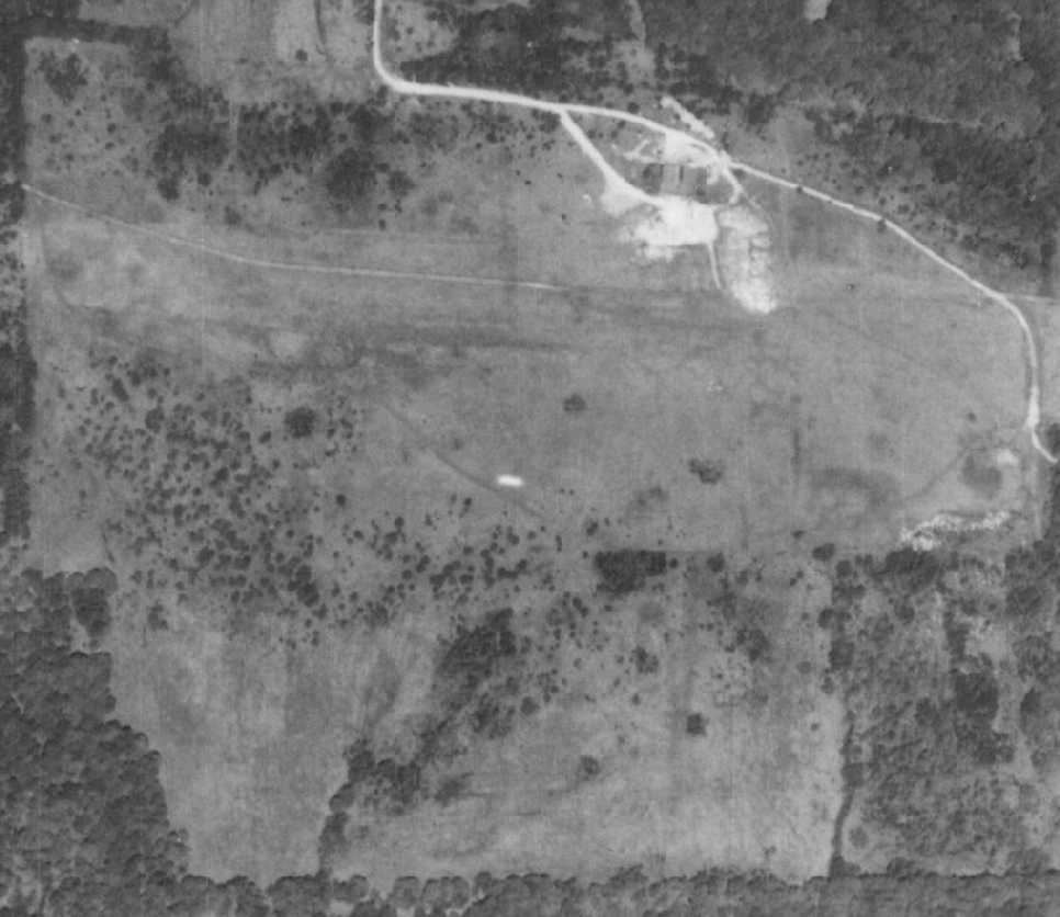
A 5/25/68 aerial photo (from the Pennsylvania Geological Survey, courtesy of James Line).
James Line observed, “There was no longer an airport, even though the hangar still stood.
A new driveway going back to a private home on the southeast side of the property now carved its way over the old runway.
Tree growth was starting to spring up on the southern end of the airport.”
Mount Jewett Airport was not depicted on the 1965 USGS topo map.
Jim Line reported, “My best friend who grew up in Mt. Jewett told me [the hangar] was there in the 1980s.”
The 1993 USGS aerial photo showed that the Mount Jewett hangar had been removed, with the foundation remaining.
Excavation had begun on the eastern portion of the airport site.
Jim Line reported of the Mount Jewett hangar site, “What I saw in 2000 was a bunch of junk piled on the original hangar foundation. ”
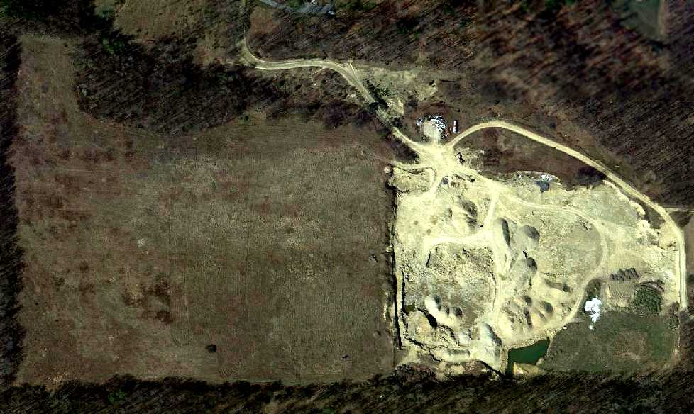
A 4/12/12 aerial view showed the property outline remained recognizable at the site of Mt. Jewett Airport.
Jim Line observed, “The airport has now become a quarry for sandstone owned by a local construction company”, covering the eastern half of the airport site.
The site of Mount Jewett Airport is located south of the end of Snowdome Road.
____________________________________________________
Mercer Airport / Intermediate Field Site 40 / Intermediate Field Site 39, Mercer, PA
41.29, -80.21 (North of Pittsburgh, PA)
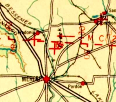
Mercer Airport, as depicted on the 1927 Bellfonte-Cleveland Airway Map (courtesy of Bill Johnson).
The date of construction of Mercer Airport has not been determined.
The earliest depiction which has been located of Mercer Airport was on the 1927 Bellfonte-Cleveland Airway Map (courtesy of Bill Johnson).
According to Richard Finley, “At one time they had a thriving airport. It boasted a flight school.
This was one of the federally funded airports established to support the U.S. Air Mail system.
It had an airway beacon light on the field & a low-frequency range station 2 miles south of the airport.”
According to Bill Johnson, “Some tidbits I learned from a relative of Samuel Tait, the owner of the land that was leased to the Department of Commerce.
The buildings on the lower right corner of the property was his home.”
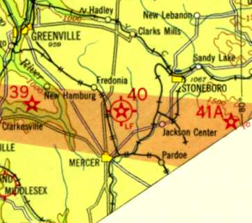
The 1930 Cleveland-Buffalo Airway Map (courtesy of Bill Johnson) depicted Mercer as Intermediate Field Site 40.
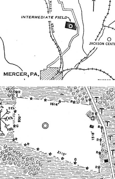
The 1/22/30 Commerce Department Airway Bulletin (courtesy of Bill Johnson) described Mercer
as Intermediate Field Site 40 along the Chicago – New York Airway.
It was said to be a 50 acre sod field owned by Samuel Tait, and operated by the Commerce Department.
The longest dimension was 2,115' northwest/southeast.
Mercer was described as being illuminated, but not having other hangars.
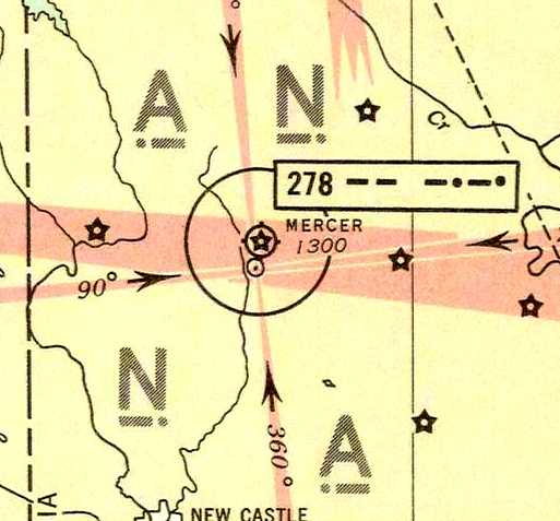
Mercer Airport, as depicted on the 1935 Regional Aeronautical Chart.
At some point between 1930-37, Mercer Airport was evidently renumbered to become Site 39,
as The Airport Directory Company's 1937 Airports Directory (courtesy of Bob Rambo)
described Mercer Airport as the Department of Commerce's Site 39 along the Chicago to New York Airway.
It was described as an irregularly-shaped sod field having 2 runways, measuring 2,650' east/west & 2,050' north/south.
The field was said to have a beacon, and boundary, approach, and obstruction lights.
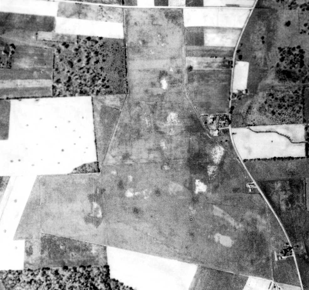
The earliest photo which has been located of Mercer Airport was a 5/12/39 aerial view (courtesy of the Pennsylvania Geological Survey).
It depicted Mercer Airport as an irregularly-shaped grass field, with a circular airport marking southeast of its center.
Several buildings were located along the east side, but it is not apparent if these were airport-related.
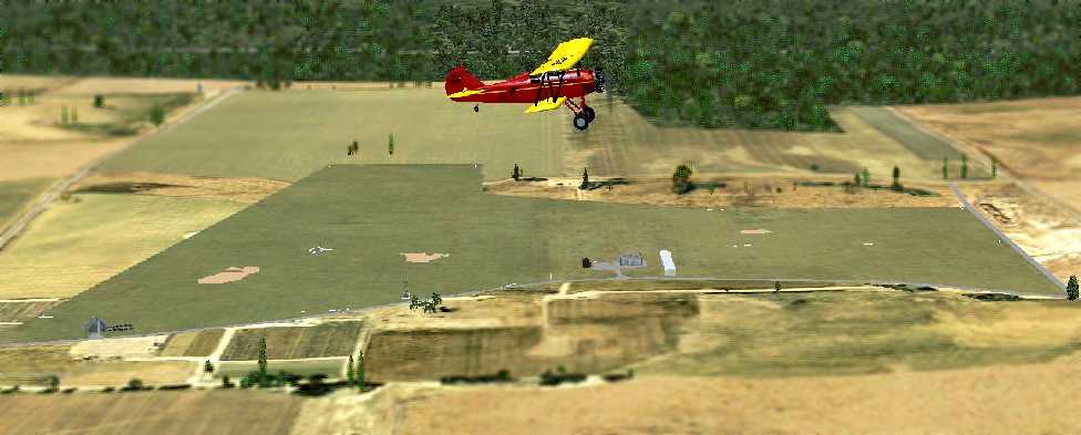
A Flight Simulator scenery re-creation of circa 1930s Mercer Airport by Richard Finley, looking west at a Travelair 2000 biplane overflying the field.
Mercer Airport was not depicted on the 1940 USGS topo map.
Interestingly, Mercer Airport was depicted in an erroneous location on the 1943 USGS topo map: across the street to the northeast.
Was this an example of wartime deception, or merely an error?
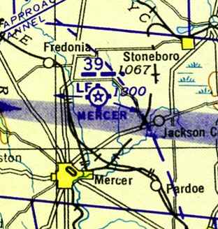
The April 1943 Cleveland Sectional Chart depicted Mercer as Intermediate Field Site 39.
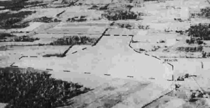
A 10/20/43 aerial view looking north from the 1945 AAF Airfield Directory (courtesy of Scott Murdock)
depicted Mercer Airport as an irregularly-shaped outline, with a beacon on the northeast side.
The 1945 AAF Airfield Directory (courtesy of Scott Murdock) described Mercer Airport
as a 150 acre irregularly-shaped property having a single 2,650' sod east/west runway & a single 75' x 60' wood & metal hangar.
The field was said to be owned & operated by private interests.
Mercer Airport was not depicted on the 1945 USGS topo map.
The 1947 Cleveland Sectional Sectional Chart (according to Bill Johnson) depicted Mercer as an "aerodrome" with complete facilities.
On the 1949 Cleveland Sectional Chart (courtesy of Bill Johnson) Mercer's description was downgraded to having "Limited Facilities".
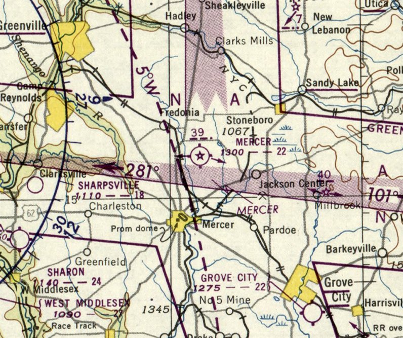
The last aeronautical chart depiction which is available of Mercer Airport was on the November 1950 Cleveland Sectional Chart.
It depicted Mercer as having a 2,200' unpaved runway, and Airway Beacon #39.
According to Richard Finley, “When government support dried up, local support just was not there & this airport faded into history.”
Bill Johnson reported, “A relative of Samuel Tait, the owner of the land that was leased to the Department of Commerce...
She said that the airport closed in 1950. The beacon tower was dismantled & moved to UCP airport.
Soon after the concrete slab where it stood became a hazard to tractors, so they planted a lone tree right over the rubble.”
Mercer Airport was no longer depicted on the June 1953 Cleveland Sectional Chart (courtesy of Ron Plante).
Bill Johnson noted of the 1955 Cleveland Sectional Chart, “The beacon #39 that is on the Green 3 Airway remained.”
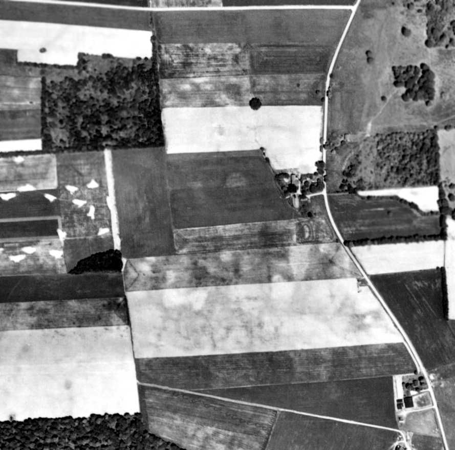
A 6/7/58 aerial photo (courtesy of the Pennsylvania Geological Survey)
showed no remaining recognizable trace of Mercer Airport, with the airfield having been taken over for farming.
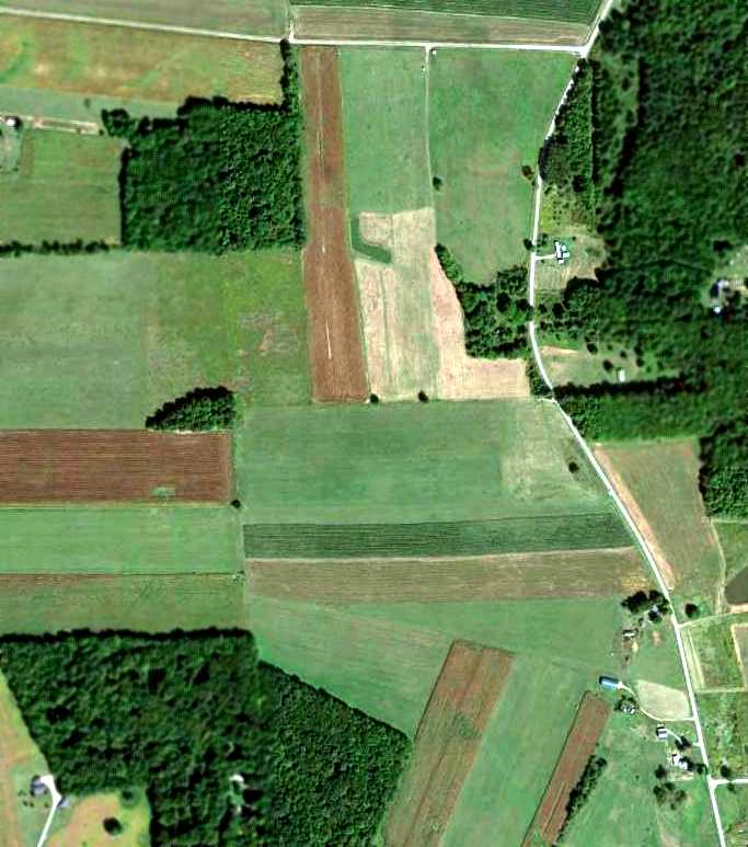
A 9/11/12 aerial view showed no obvious trace remaining of Mercer Airport.
But according to Bill Johnson, the rubble from the concrete foundation of the beacon tower “can be seen in the 2012 picture [a lone tree to the left of the bend in the road],
and the rubble is there.”
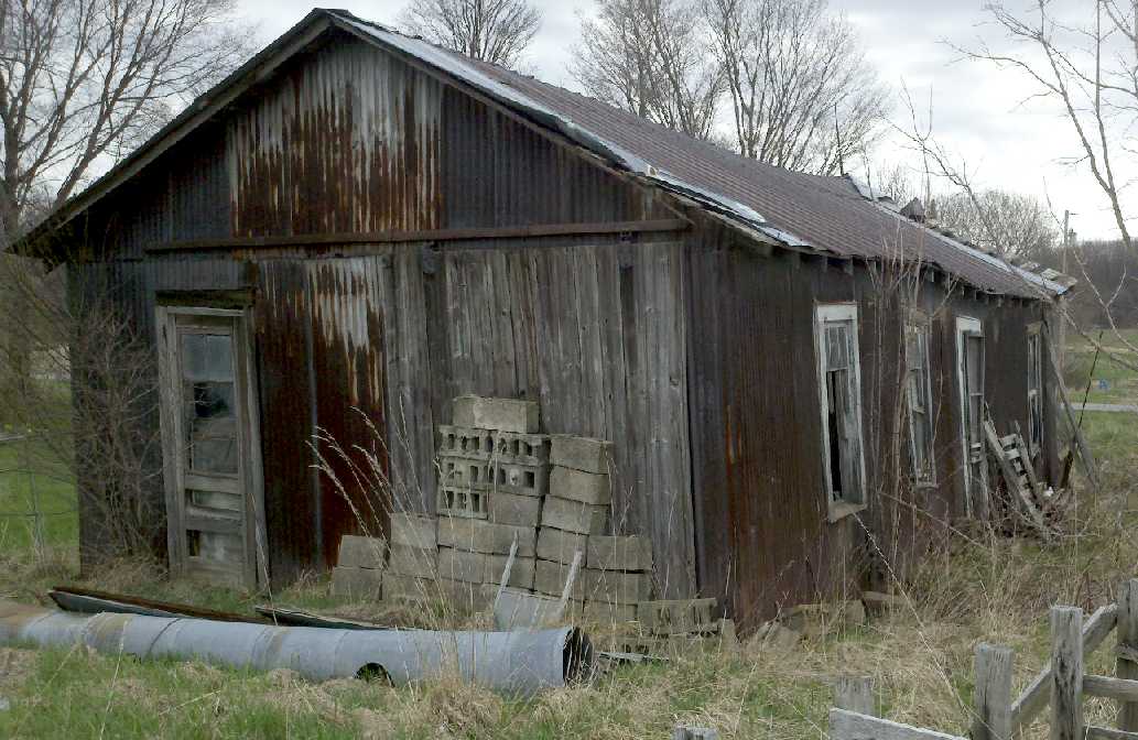
A 4/18/13 photo by Bill Johnson of “the 'shop' & office used in the 1940s & 1950s when it functioned as a public airport.
It housed what we would now call an FBO.
I am in contact with the granddaughter of the owner of that property (Samuel Tait) and have been filled in on her memories.
She remembers that most flying there had stopped in the early 1950s, with occasional plane landing even though not maintained.”
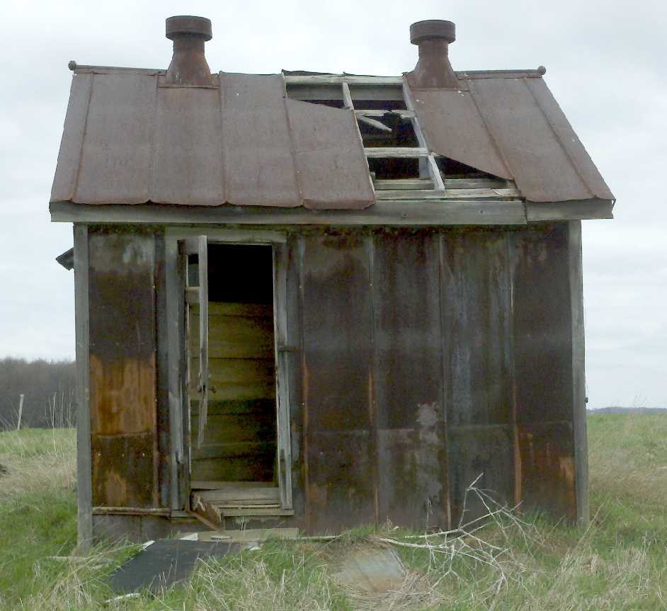
A 4/18/13 photo by Bill Johnson “of the original shack which originally was located right by the beacon tower.
It held the generator, and she remembers records (weather?) being kept there. The beacon was maintained by the government & functioned into the 1960s.
The shack was later moved to its present location, south of the original beacon. You can see the ventilation ducts for the generator.”
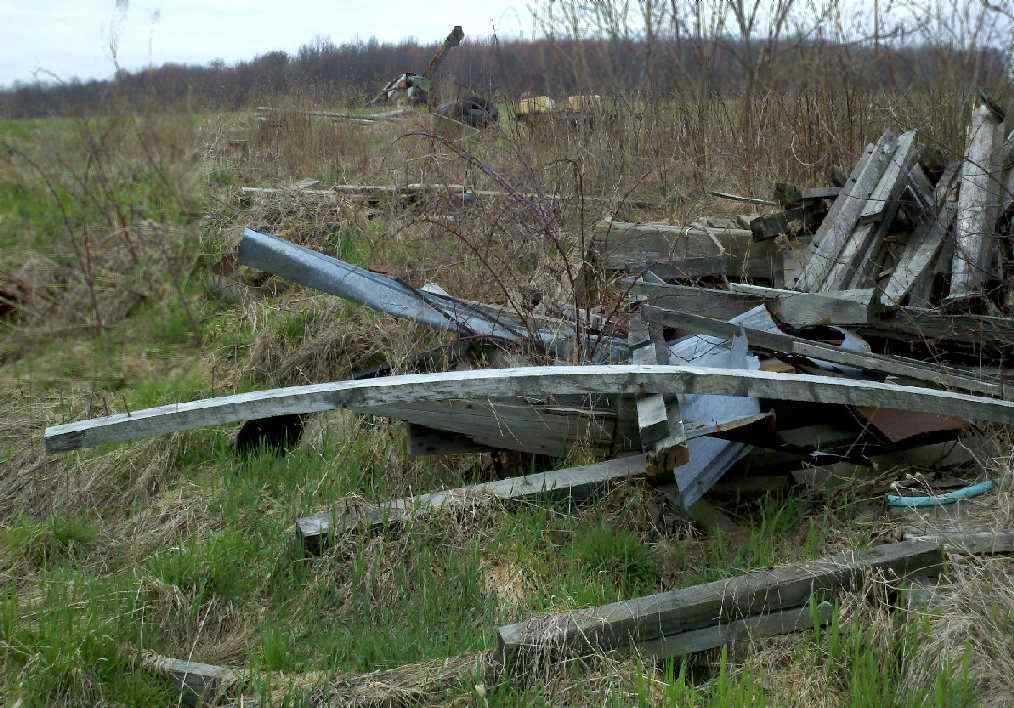
A 4/18/13 photo by Bill Johnson, who noted “There was a hangar & the scrap heap pictured is all that is left.”
The site of Mercer Airport is located southwest of the intersection of Holmes Road & Airport Road, appropriately enough.
____________________________________________________
Oil City Glider Club Gliderport / Splane Memorial Field (KOIL), Oil City, PA
41.5, -79.73 (Northeast of Pittsburgh, PA)
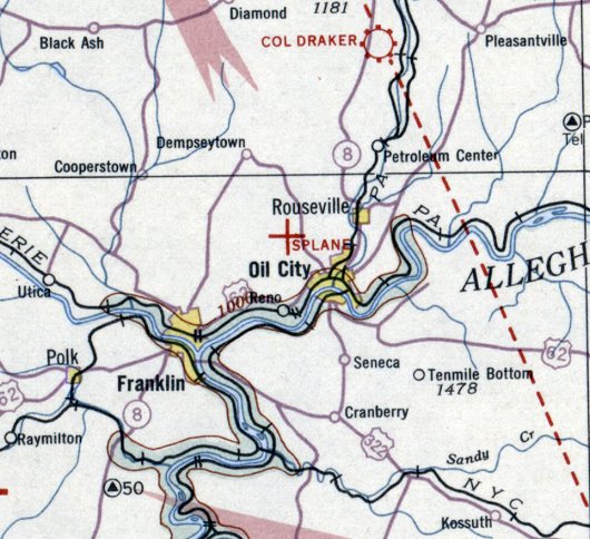
Splane Memorial Field, as depicted on the December 1932 Cleveland Sectional Chart.
According to Richard Finley, “An airport committee was organized in 1928
and the facility initially opened in 1929 as a gliderport operated by Oil City Glider Club, 1929-30.
The glider club owned a Curtiss glider. In 1931 one of their members, Douglas Brown, formed Oil City Aero Club.
The Aero Club got the W. W. Splane family to donate $50,000 to buy land where they were operating,
to build an airport for Oil City named after their son, Alvin Splane who was a WWI aviator who did not survive the war.
The Aero Club turned airport over to the City of Oil City to operate (and qualify for WPA support).”
The earliest depiction which has been located of Splane Memorial Field was on the December 1932 Cleveland Sectional Chart,
which depicted Splane as an auxiliary airfield.
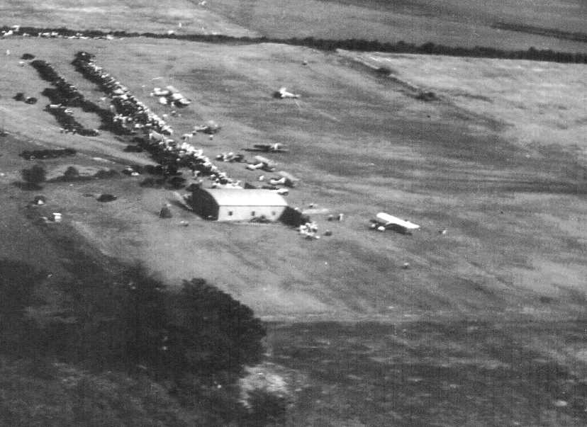
The earliest photo which has been located of Splane Memorial Field was a 1934 aerial view looking southeast at some type of gathering (courtesy of Richard Finley),
showing a large number of cars, 8 aircraft, and a hangar.
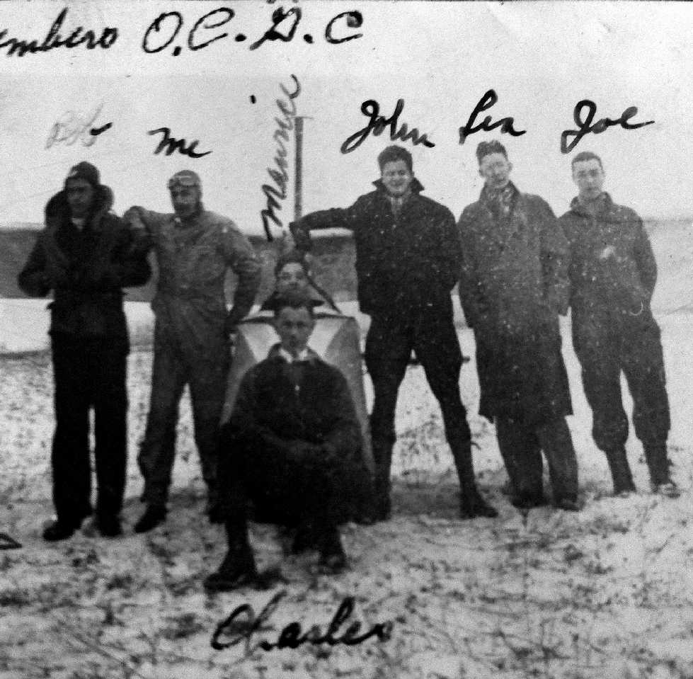
A 1934 photo (courtesy of John Salkin) of the members of the Oil City Glider Club,
including his father Lester Salkin (marked “Les”) and his brother Sidney Salkin (marked “me”) in front of an unidentified glider.
According to Richard Finley, “In 1935 WPA built the hangar/office, paved the ramp, taxiway and east/west runway.
When the paved runway was built, it was the only paved runway between Pittsburgh & Buffalo.
Splane Memorial Airport was the Oil City airport
but during the 1930s & 1940s it was the focus of aviation for Oil City, Franklin and to some extent Titusville and Meadville.”
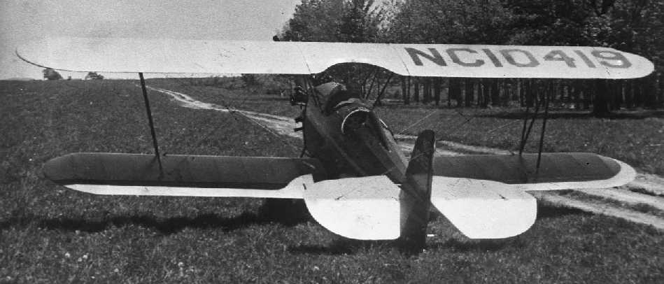
A 5/21/37 photo of a Franklin Sport biplane reportedly taken at Splane Memorial Field.
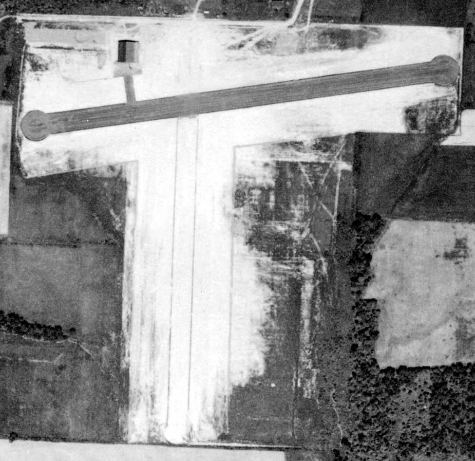
A 6/6/39 aerial photo (courtesy of the Pennsylvania Geological Survey) showed what appeared to be a newly-paved east/west runway at Splane,
along with a paved ramp leading to a hangar on the northwest side, and a crosswind grass runway.
No aircraft were visible on the field.
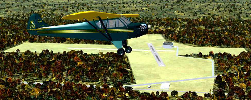
A Flight Simulator scenery re-creation of Splane Memorial Field by Richard Finley,
looking west at a Taylor J-2 Cub overflying the field.
According to Richard Finley, “While in its heyday, Splane was home to many interesting aircraft
such as an Akron Funk, a Taylor H-2 Cub with a 3 cylinder Aero Marine radial engine, a Taylor J-2 Cub and a (Bauer 170) Franklin Sport.
They have had a Ford Trimotor & a Lockheed Model 14 Super Electra there, and a Cessna Bobcat based there.”
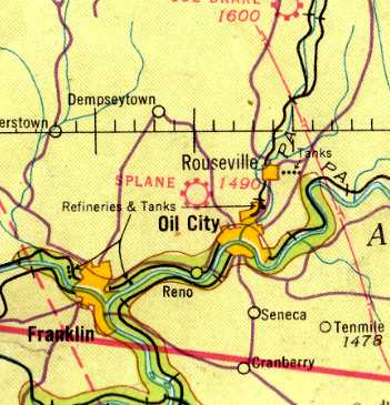
The March 1940 Cleveland Sectional Chart (courtesy of Richard Finley) depicted Splane as a commercial/municipal field.
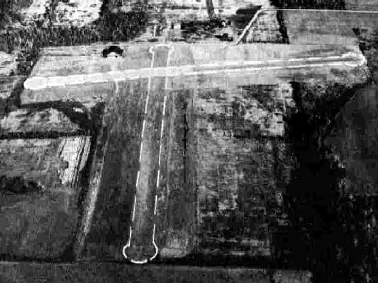
A 10/21/43 aerial view looking north from the 1945 AAF Airfield Directory (courtesy of Scott Murdock)
depicted Splane Memorial Airport as having one paved runway & one grass runway,
and a hangar to the northwest.
According to Richard Finley, “Unfortunately, Splane's location severely limited its ability to be expanded beyond its 2,000' runways.
That made Splane unusable by most modern business planes & certainly any modern air carrier airplanes.
Around 1944 the hangar/office burned down. That began Splane's decline.”
The 1945 AAF Airfield Directory (courtesy of Scott Murdock) described Splane Memorial Airport
as an 82 acre T-shaped property having a paved 2,160' east/west runway & a grass 2,130' north/south runway.
The field was said to have 2 hangars, the largest being a 100' x 80' concrete & metal building.
Splane Memorial Airport was described as being owned by the City of Oil City, and operated by private interests.
The November 1950 Cleveland Sectional Chart depicted Splane Memorial as having a 2,200' paved runway.
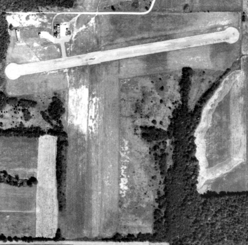
A 8/27/58 aerial photo (courtesy of the Pennsylvania Geological Survey) showed the location of the former hangar (which had reportedly burned down in 1944)
was replaced with 2 smaller buildings, one on either side, the western one being painted with “Oil City” on its roof.
Two light aircraft were visible around the ramp.
The July 1960 Cleveland Sectional Chart depicted Splane Memorial as having a 2,200' paved runway.
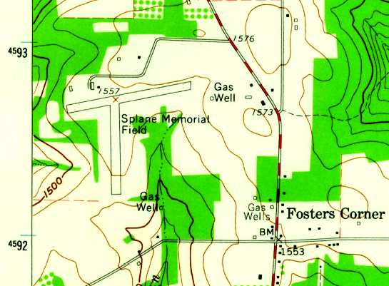
The 1963 USGS topo map depicted Splane Memorial Field as having 2 paved runways, and a building northwest of the runway intersection.
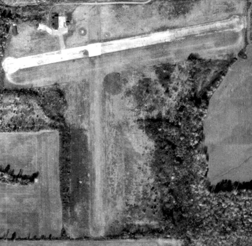
A 10/30/68 aerial view (courtesy of the Pennsylvania Geological Survey)
showed that Splane's paved runway was considerably deteriorated compared to the 1958 photo.
The buildings were still intact, but there were no aircraft visible, or other signs of recent aviation use.
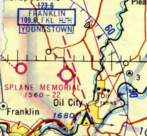
The last aeronautical chart depiction which has been located of Splane Memorial
was on the November 1968 Cleveland Sectional Chart (courtesy of Richard Finley).
It depicted Splane Memorial as having a 2,200' paved runway.
According to Richard Finley, “Splane, in its final days, was operated by volunteers from the Oil City Aero Club.
By the 1970s the paved runway was unusable. The airport was finally closed by the city of Oil City in 1972.”
Splane Memorial Airport was no longer depicted on the November 1972 Detroit Sectional Chart (according to Richard Finley).
A 1993 USGS aerial photo showed that Splane's airport buildings had been removed at some point between 1969-93.
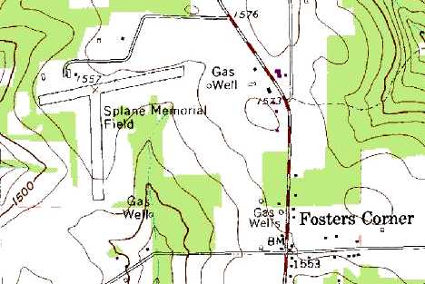
The 1995 USGS topo map continued to depict Splane Memorial Field,
with 2 runways, and a building on the northwest corner.
A 2005 aerial photo showed that the runway pavement had been removed from the east/west runway at some point between 1993-2005.
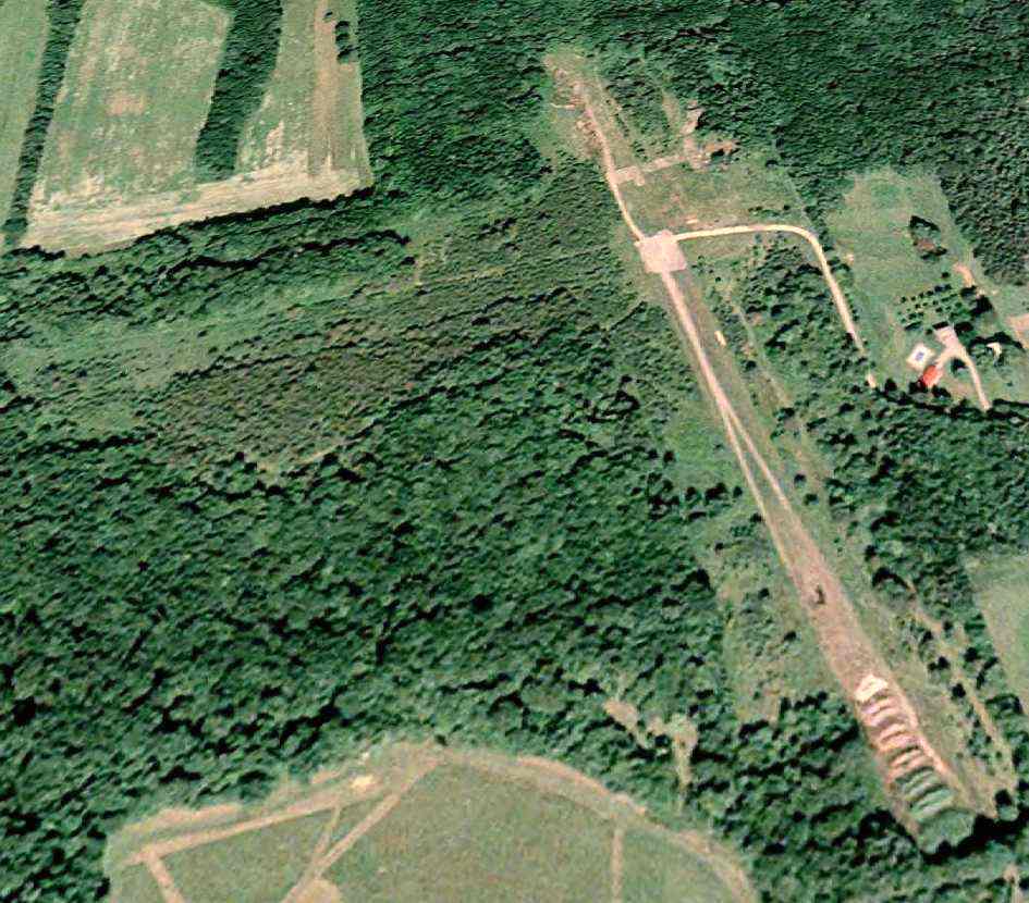
A 5/28/08 aerial view looking northwest showed that the east end of Splane's east/west runway was being used to store mulch/compost,
and the outline of the north/south runway was barely recognizable.
Richard Finley reported in 2010, “It is currently the mulching/composting site for the City of Oil City's leaf removal program.
The sole hangar building shown in the picture is now partially collapsed.”
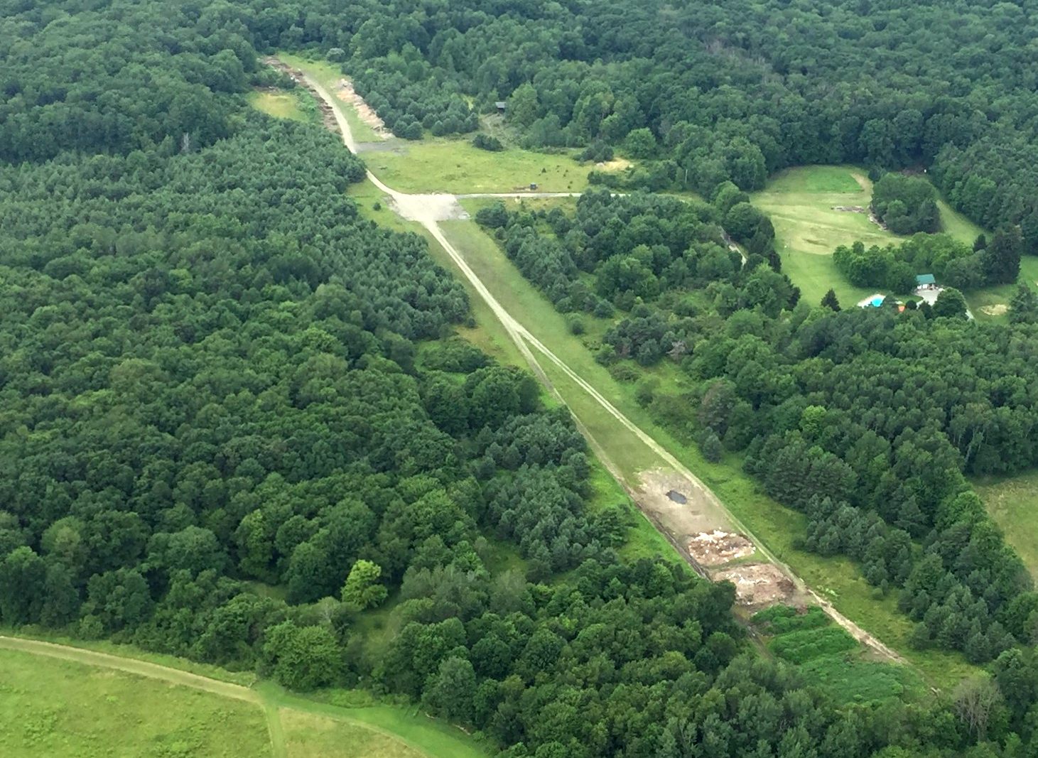
A 7/6/17 aerial view by Bill Pixley looking northwest at the site of Splane Memorial Airport
showed that the remnants of the east/west runway was still recognizable, but the north/south runway was overgrown with trees.
The site of Splane Memorial Field is located at the western terminus of Old Splane Airport Road, appropriately enough.
____________________________________________________
Brookville Airport, Brookville, PA
41.15, -79.1 (Northeast of Pittsburgh, PA)
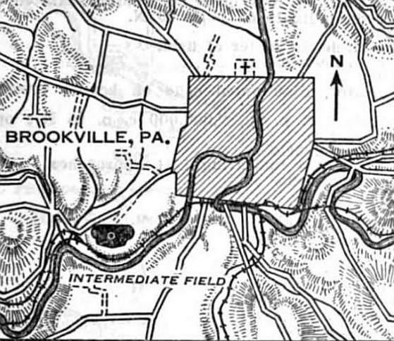
Brookville Intermediate Field, as depicted on the 7/26/29 Commerce Department Airway Bulletin (courtesy of Mike Denja).
According to Jonathan Westerling, “In the early decades of aviation Brookville was a stop along the New York to Chicago Airway,
a line of hundreds rotating hilltop lights guiding pilots from city to city.
Pilots used the Brookville airfield as a resting place, to wait out a storm, or make an emergency landing.
The airfield is interesting in that it started life at the center of a large horse racing track.”
Jonathan continued, “The first reference to the Brookville airfield is in the 1923 Airplane Landings Guide
which described the airfield simply as a race track, after all these were the early days of aviation when a landing field was sometimes literally a field.”
Jonathan continued, “The 1925 Aeronautical Bulletin described it as a 2,000' x 800' good surface for landing.”
No airfield in Brookville was depicted on the 1926 USGS topo map.
The earliest depiction which has been located of Brookville Airport was on the 7/26/29 Commerce Department Airway Bulletin (courtesy of Mike Denja).
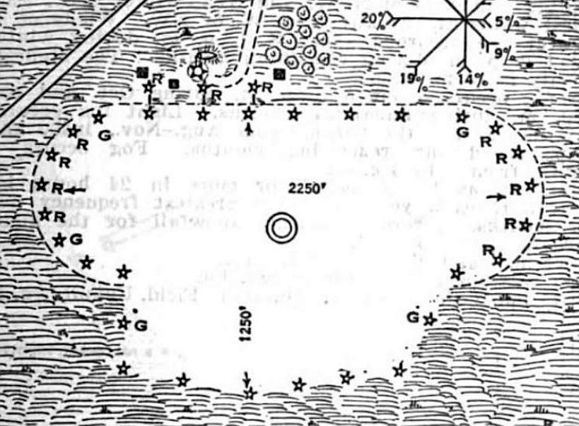
The 7/26/29 Commerce Department Airway Bulletin (courtesy of Mike Denja) described the Brookville Intermediate Field
as being owned by Fred Henderson & operated by the Commerce Department.
The field was said to consist of a 68 acre irregularly-shaped sod field, measuring 2,250' east/west.
A few small buildings were depicted along the north side.
According to Jonathan Westerling, “Despite its ample size & functionality, the airstrip remained labeled for emergency use only.
This could be because the owners of the land continued to operate their land primarily as a race track.
As the U.S. Government developed Airways as virtual roads in the sky to aid nighttime navigation & the Air Mail service,
it purchased land for airfields along the way.
If Brookville was like most of these Government Airway fields, sometime in the late 1920s,
the owners of the race track accepted a lease offer from the government, and a formal intermediate facility was constructed on the site.”
The 1931 Aeronautical Bulletin #2 (courtesy of David Brooks) listed Brookville as having 2 runways: 2,250' east/west & 1,250' north/south.
Jonathan Westerling observed, “The government furnished the airfield with all the modern aviation accouterments of the time
including a non-directional radio beacon (callsign WINQ), boundary lights, a 24 inch rotating beacon & weather teletype.
The official designation for this airfield was #45A.”
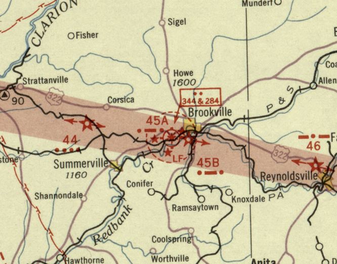
The earliest aeronautical chart depiction which has been located of the Brookville Airport was on the December 1932 Cleveland Sectional Chart.
Jonathan Westerling observed, “The 1938 Bulletin #2 shows several improvements had occurred at Site 45A.
The rotating beacon was replaced with a larger 36 inch model,
and blinking green indicator lights had been placed on the nearby hill & on the field itself
indicating in morse code the name of the airfield & any landing obstructions.
An additional radio beacon, was installed at the site.
One was at 224 khz & the other at 344 khz. It is not known why the site was allocated 2 beacons.”
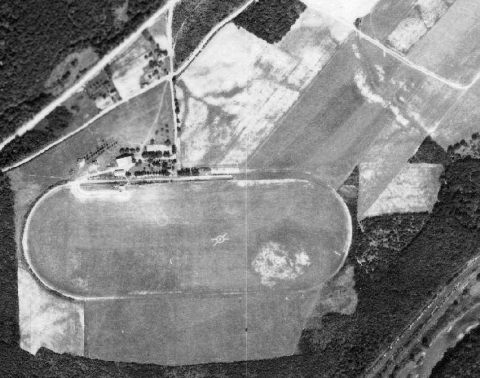
The earliest photo which has been located of the Brookville Airport was a 9/15/39 aerial view (courtesy of the Pennsylvania Geological Survey).
It showed the field to consist of 2 grass runways laid out over the former horse track, with the white airport symbol in the center.
The field also had large hangar, 3 T-hangars, and 3 other support buildings.
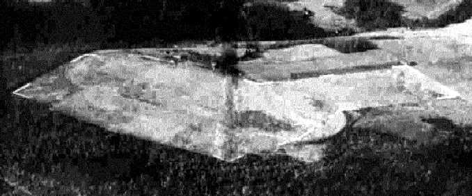
A 10/29/43 aerial view looking northwest from the 1945 AAF Airfield Directory (courtesy of Scott Murdock)
depicted at the Brookville Airport as having 2 grass runways,
one a wide east/west 3,000' long runway east/west inside the prior racetrack,
and a 2,200' northeast/southwest strip jutting off from the east side of the track.
According to Jonathan Westerling, “Following WWII, the community inquired with the Civil Aeronautics Administration
as to whether or not the town could operate the field as a municipal airport instead of just an intermediate airfield.”
In a February 1946 letter, Herbert DePue Acting Superintendent of Air Navigation
replied that “The policy of the Civil Aeronautics Administration makes control of the airport possible
providing same public agency will assume the responsibility of maintaining the landing area surface
and all costs in connection with land rentals & charges covering permission
to construct & maintain obstruction lights or other facilities used in connection with the field.
The Brookville Pennsylvania Intermediate Landing Field now has an A-I status,
in that it is a field established by the Civil Aeronautics Administration without assistance from local [government]...
Should a local [government] in this instance take over the rental & field maintenance, commercial operations on this field...
the [Federal] Government would desire to enter into an agreement with the local body concerned,
which would allow the Government to continue to maintain & operate the field lighting equipment
and such other facilities as the Government might feel were required to serve the airway.
We have entered into such an agreement with a number of municipalities
and will be glad to do so in connection with the Brookville-Pennsylvania Intermediate Landing Field.
In the event a local body takes over the field for maintenance & operation,
it will be necessary for them to make their financial arrangements regarding the Ieasing or purchasing of the land directly with the property owner.”
According to Jonathan Westerling, “It is not known whether the community pursued converting the airfield to municipal use.
A few years later, Jefferson County assembled a Municipal Airport Authority to identify a location for a county airfield
which examined, but did not choose Brookville as the site of the future county airport.”
Jonathan
continued, “The 1947 Directory of Airfields indicates that fuel
facilities had been installed at Brookville.”
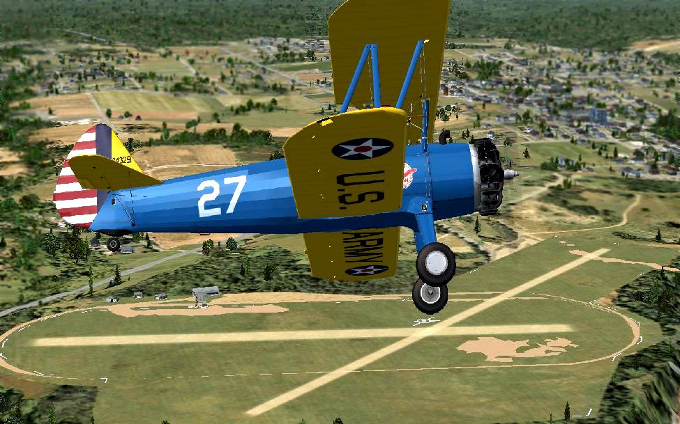
A Flight Simulator scenery re-creation of a Stearman overflying Brookville Airport by Richard Finley.
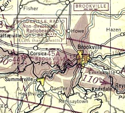
Brookville Airport, as depicted on the January 1947 Cleveland Sectional Chart (courtesy of Jonathan Westerling).
The 1949 Cleveland Sectional Chart (courtesy of Jonathan Westerling) depicted “Brookville (CAA)” as having a 3,000' unpaved runway.
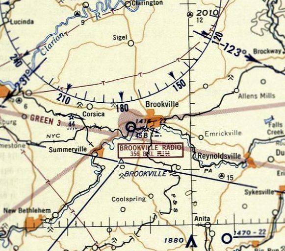
The last aeronautical chart depiction which has been located of Brookville Airport was on the July 1955 Cleveland Sectional Chart.
It depicted Brookville Airport as having a 2,200' unpaved runway.
The Brookville Intermediate Field was evidently closed at some point in 1955,
as it was no longer depicted on the December 1955 Cleveland Sectional Chart.
A 1959 aerial photo (courtesy of the Pennsylvania Geological Survey) showed that the large hangar had been removed at some point between 1939-59,
along with the airport symbol in the center of the field, but the other support buildings remained.
The
Brookville Intermediate Field was not depicted on the 1969 USGS topo
map.
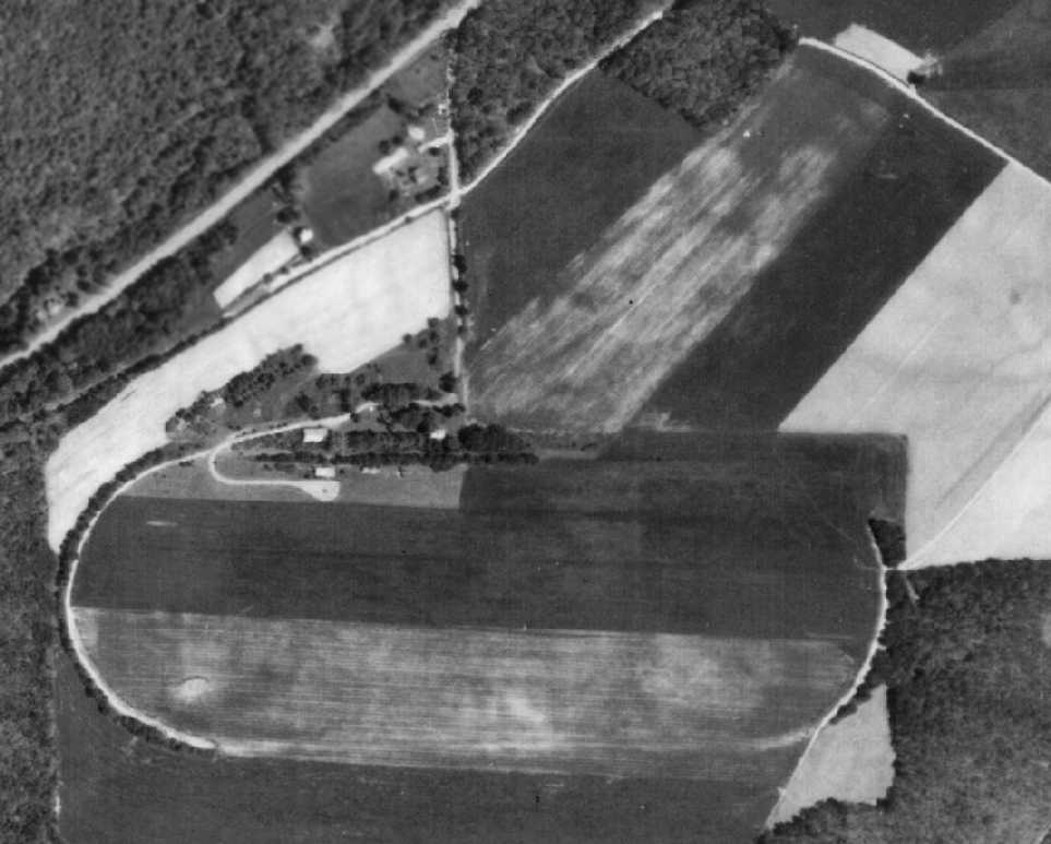
A 5/27/69 aerial view (courtesy of the Pennsylvania Geological Survey) showed that Brookville's T-hangars had been removed at some point between 1959-69.
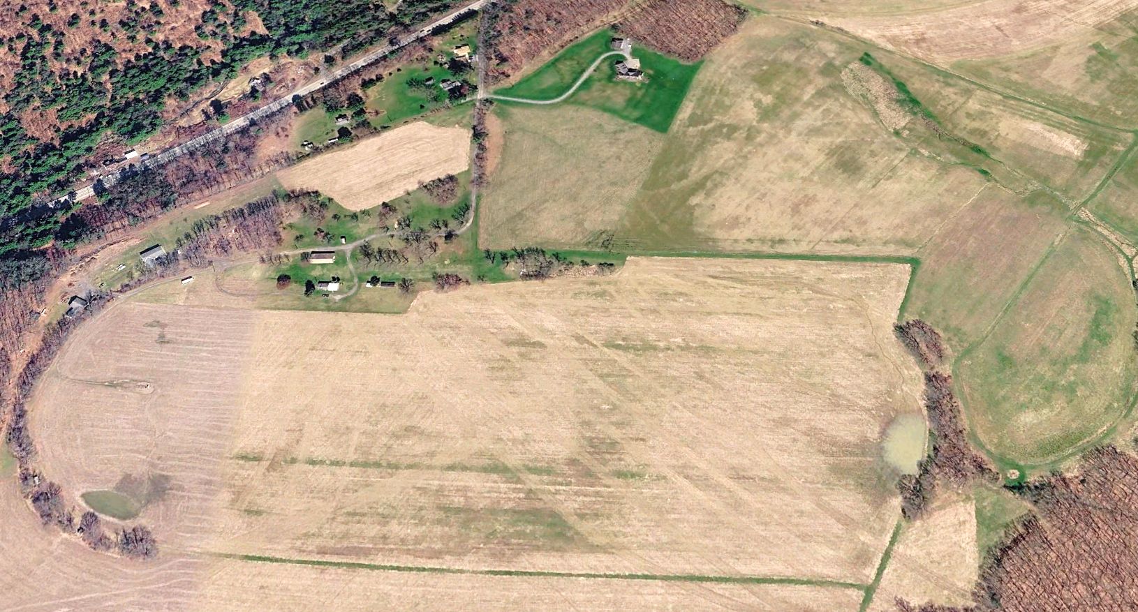
A 2025 aerial view looking north at the site of Brookville Airport showed that the racetrack oval shape was still recognizable, along with the former northeast/southwest runway.
It is not known if any of the buildings still on the site date from its days as an airfield.
The site of Brookville Airport is located south of the intersection of Route 28 & Airport Road, appropriately enough.
____________________________________________________
(Original) Grove City Airport, Grove City, PA
41.14, -80.07 (North of Pittsburgh, PA)
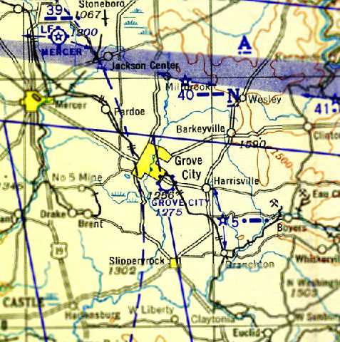
The original Grove City Airport, as depicted on the April 1943 Detroit Sectional Chart (courtesy of Chris Kennedy).
The original airport for the town of Grove City was located southeast of the town.
It apparently had 2 distinct lives over the years, with 2 different purposes.
The Grove City Airport evidently was opened at some point between February 1942 – April 1943,
as it was not yet depicted on the February 1942 Detroit Sectional Chart (according to Chris Kennedy) or on the 1943 USGS topo map.
The earliest depiction which has been located of the Grove City Airport was on the April 1943 Detroit Sectional Chart (courtesy of Chris Kennedy).
It depicted Grove City as a commercial/municipal airport.
According to John Hazlet, the Grove City Airport may have been used for flight training during WW2 by the Civilian Pilot Training program.
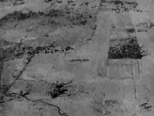
The earliest photo which has been located of the Grove City Airport
was a 10/20/43 aerial view looking north from the 1945 AAF Airfield Directory (courtesy of Scott Murdock).
The 1945 AAF Airfield Directory (courtesy of Scott Murdock) described Grove City Airport
as a 75 acre irregularly-shaped property within which were 2 sod runways, measuring 1,930' north/south & 1,560' northeast/southwest.
The field was said to have 2 concrete block & steel hangars, measuring 132' x 60' & 65' x 60'.
Grove City Airport was described as being owned & operated by private interests.
Grove City was still depicted as a public-use airport on the January 1949 Cleveland Sectional Chart (courtesy of Chris Kennedy),
with a 2,200' unpaved runway.
The Grove City Airport was evidently closed (for the 1st time, for reasons unknown) at some point between 1949-55,
as it was no longer depicted on the January 1955 Detroit Sectional Chart (according to Chris Kennedy).
Grove City Airport was still not depicted on the January 1958 Detroit Sectional Chart (according to Chris Kennedy).
This little airport evidently got a 2nd lease on life when it was expanded & reopened as a private airfield
at some point between January 1958 – July 1958,
as it was depicted as a private airfield on the July 1958 Detroit Sectional Chart (courtesy of Chris Kennedy).
It was depicted as having 2 paved runways, with the longest being 2,400'.
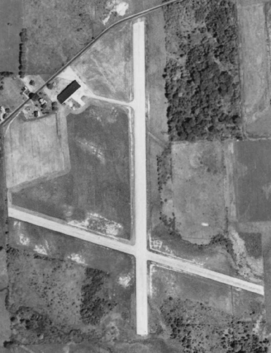
A 6/5/1958 aerial view (from Penn Pilot) depicted Grove City Airport to consist of 2 paved runways, with a taxiway leading to a ramp with a hangar & several other buildings on the northwest side.
No planes were visible on the field.
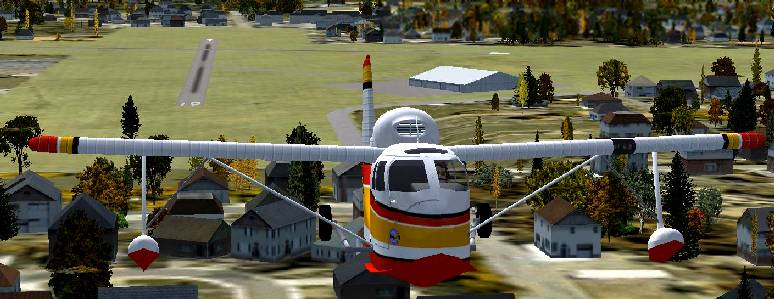
A Flight Simulator scenery re-creation by Richard Finley of a Republic Seabee departing Grove City Airport.
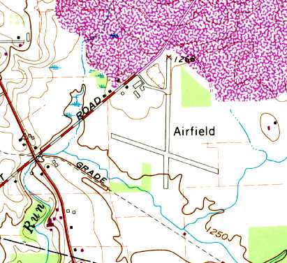
The 1961 USGS topo map depicted Grove City Airport as having 2 paved runways, with several buildings along the northwest side.
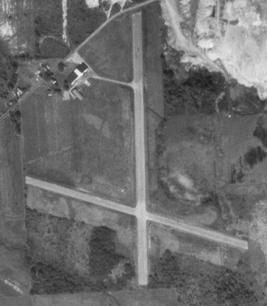
An October 1968 aerial photo depicted Grove City Airport as unchanged from the 1958 photo.
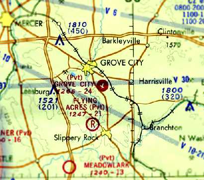
The last aeronautical chart depiction which has been located of the original Grove City Airport
was on the May 1971 Detroit Sectional Chart (courtesy of Chris Kennedy).
A replacement Grove City Municipal Airport was opened in 1975 to the west of the city.
The original Grove City Airport was evidently abandoned by 1976,
as only the new Grove City Airport was depicted on the December 1976 Detroit Sectional Chart (according to Chris Kennedy).
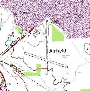
The 1981 USGS topo map still depicted the 2 runways, taxiway, ramp, and several buildings,
but labeled simply as “Airfield”, which probably means it was no longer operational by that point.
The 1993 USGS aerial photo showed that the hangar & ramp had been removed at some point between 1968-93,
with only some smaller buildings remaining on the west side.
It also appeared as if all of the the runway pavement had been removed from both runways.
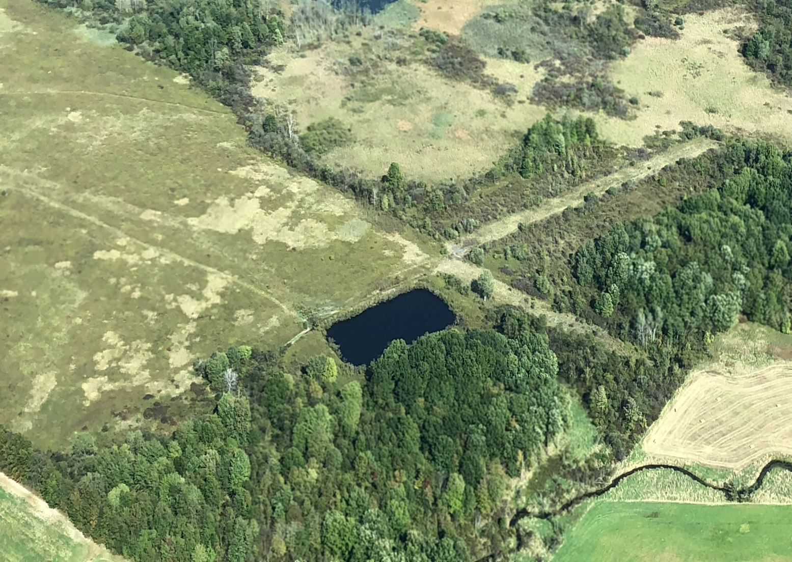
A 9/29/17 aerial view by Bill Pixley looking east showed that the layout of the 2 Grove City runways was still perceptible, but all pavement had been removed.
The site of the original Grove City Airport is located east of the intersection of Route 173 & Airport Road, appropriately enough.
Thanks to John Hazlet for pointing out this airfield.
____________________________________________________
Or if you prefer to contact me directly concerning a contribution (for a mailing address to send a check),
please contact me at: paulandterryfreeman@gmail.com
If you enjoy this web site, please support it with a financial contribution.
____________________________________________________
This site covers airfields in all 50 states.