
Abandoned & Little-Known Airfields:
Southeastern Wisconsin
© 2002, © 2026 by Paul Freeman. Revised 4/20/26.
This site covers airfields in all 50 states: Click here for the site's main menu.
____________________________________________________
Please consider a financial contribution to support the continued growth & operation of this site.
Beaver Dam Airport (1st location) (added 9/30/25) - Beaver Dam Airport (2nd location) (added 9/30/25) - Chaplin Airpark (added 4/9/24) – Madison North Street Airport (revised 3/1/25)
(Original) Fond du Lac Airport (revised 2/22/23) - Hales Corners Airport (revised 12/24/25) - Janesville City Airport (revised 4/3/20)
- Playboy Airport / Americana Airport / Lake Geneva Airport / Grand Geneva Airport (revised 4/20/26)
Royal Airport / Pennco Field / Four Lakes Airport (revised 1/7/19) - Vincent Airfield (added 9/9/23) - Westosha Airport (revised 2/22/23)
____________________________________________________
Playboy Airport / Americana Airport / Lake Geneva Airport / Grand Geneva Airport (C02), Lake Geneva, WI
42.613, -88.393 (Southwest of Milwaukee, WI)
Playboy Airport, as depicted on the May 1970 Milwaukee Sectional Chart.
According to Andy Gelston, the Playboy Airport “was built in mid-1967 / early-1968 & finished in time for the resort's grand opening in early summer of 1968.
The runway was built by local paving contractor, Miller Paving, adjacent to a swamp, on the only level spot within the 1,300 acre plot.
Hugh Hefner flew in for the grand opening in his DC-9, Big Bunny, and broke the runway threshold from the weight of the mains.
Miller was called in to rebuild the threshold... to the specs that should have been called out in the original contract,
while that big black bird with the white bunny head on the vertical tail, languished on sheets of plywood, out on the ramp. She never returned.
The strip was always paved & well-maintained when Playboy owned it.
There was a trap & skeet range off the northwest side of the runway, at the midway point, with a clubhouse & small parking area.
The barn was never affiliated with the airport. It housed the riding stable where visitors could take trail rides on the bridle paths throughout the grounds, and go on Belgian draft horse pulled hayrides.
There was a small, 2-room, airport office where pilots would go to sign in & pay a $3 landing fee. Tie-downs on the ramp were ropes attached to long chains anchored to the macadam.
Fuel available was 100LL from an ancient truck that sometimes dispensed water after a heavy downpour.”
The Playboy Airport was not yet depicted on the 1969 Milwaukee Sectional Chart.
The earliest depiction which has been located of the Playboy Airport was on the May 1970 Milwaukee Sectional Chart.
It depicted Playboy as having a single paved 4,100' northeast/southwest runway.
According to Wikipedia, commuter air service was available directly from Chicago O'Hare Airport to the Playboy Airport.
The airport comprised 20 acres, and had a 4,100' asphalt Runway 5/23.
The earliest photo which has been located of the Playboy Airport was a 1971 aerial view.
It depicted Playboy as having a single paved northeast/southwest runway, with over a dozen light aircraft parked on the northwest side.

The earliest topo map depiction which has been located of the Playboy Airport was on the 1972 USGS topo map.
It depicted “Playboy Landing Field” as having a single paved northeast/southwest runway & parallel taxiway, and a few small buildings on the northwest side.
Andt Gelston observed, “The 1972 topo shows 2 barns (white) & the Buildings & Grounds Maintenance building (dark rectangle), but not the pilot shack & the shooting range.”
According to Andy Gelston, “Lake Geneva Airways operated a Howard 500 twin (ORD /CO2 commuter) until early 1973, when it started losing money.
There were about a dozen light singles & a flight school based there in the 1970s/1980s.
A local family named Gelderman built the only hangar on the field in the mid-1980s for their Cessna 172. (It now houses buildings & grounds equipment).
Entertainers & celebrities flew in to stay or perform at the resort. The Smothers Brothers flew Dick's Archer in & Dick hung out at the pilot shack.”
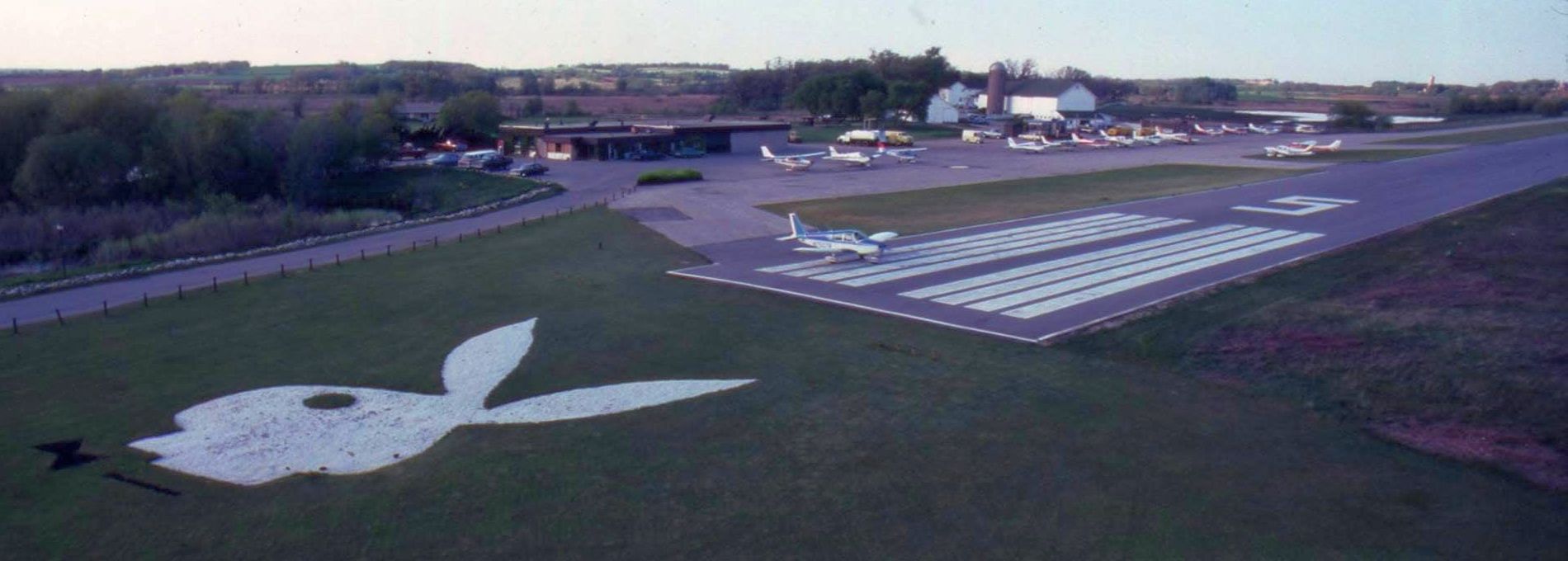
A circa 1970s/80s aerial view looking north at the Playboy Airport Runway 5 threshold, showing the prominent Playboy Bunny logo just before the runway.
Andy Gelston recalled, “The bunny head at the end of [Runway] 5 was made of white gravel, and its bow tie was black gravel; very striking when on final.”

An undated photo of a retractable gear glider in front of the barn at the Playboy Airport.
It was still depicted as Playboy on the 1974 Chicago Sectional Chart.
Andy Gelston recalled, “The last year that Playboy owned the airport (1982), business was slow, so I persuaded resort management to place in the very bottom of their ads, 'Fly into our airport (CO2).' Business boomed.”
The bunny head was sodded over as soon as Ameicana bought the place (the only investment Americana ever put into the airport, other than plowing snow off the runway).
When Americana bought the place in late 1982, they admonished me (as airport manager) that they wouldn't invest one penny into the airport.
It had to be self-sustaining & they would mention the airport in their advertising only if the airport paid 10% of the cost of those ads, in advance. That didn't happen.”
The airport was depicted Americana (after the new hotel owner) on the 1985 Chicago Sectional Chart.
Andy Gelston recalled, “Americana legal didn't like the exposure of the airport being named after the corporation, so changed the name to Lake Geneva.
After sucking the resort dry & going into foreclosure in 1986, Americana eventually sold the place to JMB Realty in 1988, who also ignored the airport, folding 4 years later.
Marcus Hotels acquired the resort in 1993 and the airport name changed for the last time, to Grand Geneva.”
The airport was depicted as Lake Geneva on the 1993 Chicago Sectional Chart.
Andy Gelston recalled, “Other than removing the derelict pilot shack & fuel tank & truck, Marcus ignored the airport like Americana &d JMB, until 1997, when they had the airport improved to meet FAA standards.”
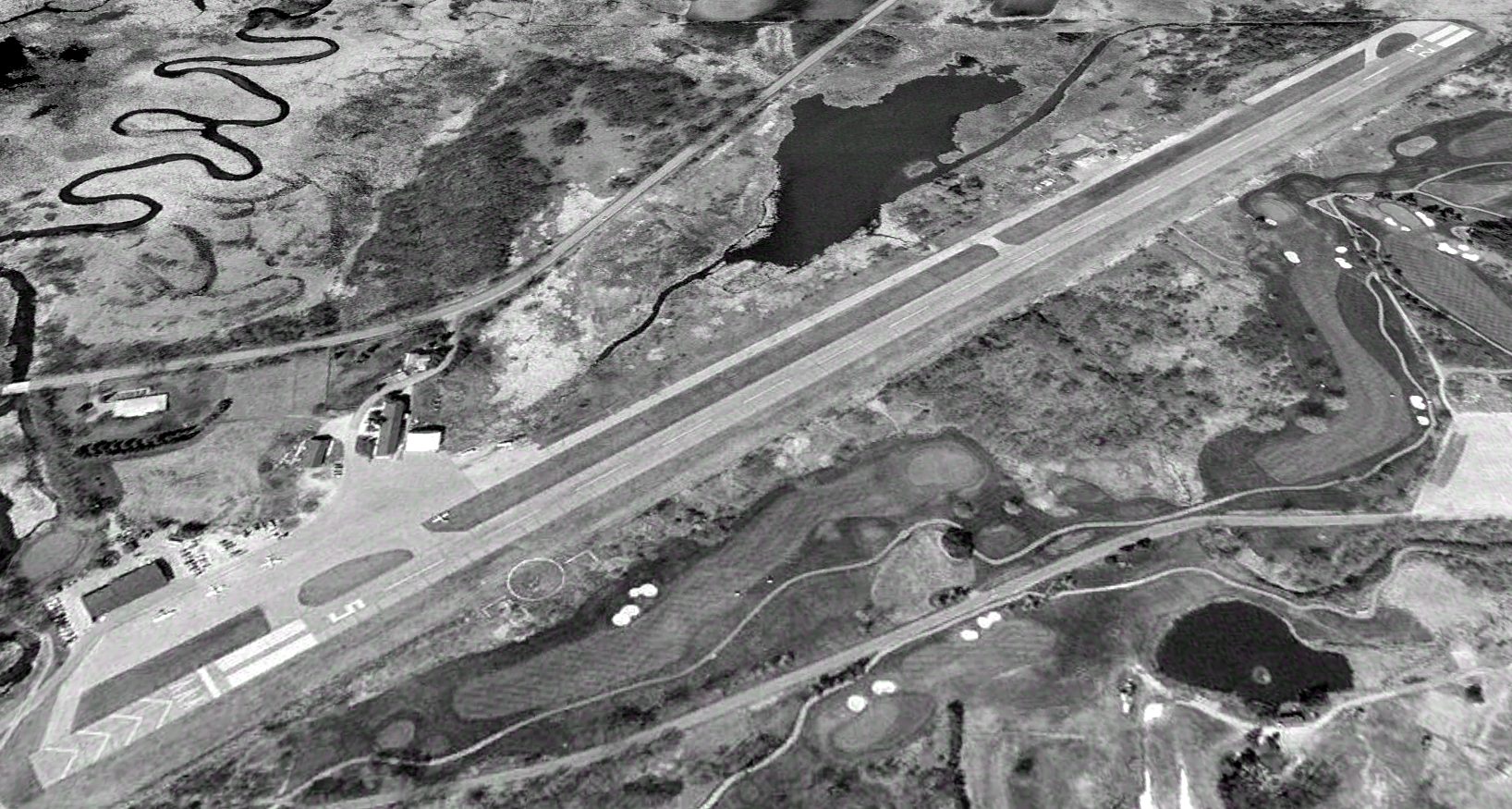
A 2000 aerial view looking north showed Lake Geneva Airport to have an asphalt Runway 5/23, with 4 light aircraft on its ramp.
The airport was depicted as Grand Geneva on the 2001 Chicago Sectional Chart.
Andrew Thome recalled of Grand Geneva Airport, “I was lucky enough to land here once though probably not recommended at the time as it was already in bad shape.”
Andy Gelston recalled, “By the late 2000s, the improvements to the taxiway succumbed to weather & having been accomplished by very low bidders, and was closed off with Jersey barriers.
The last commercial operation at the airport was Ted Davis hopping tourists in his 1929 D-25 Standard biplane in the late 2000s.”
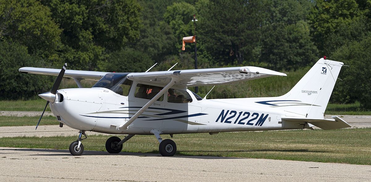
An 8/11/22 photo of a Cessna 172 at Grand Geneva Airport.

A 2023 aerial view looking north showed Grand Geneva Airport as remaining intact, though devoid of aircraft.

A 2023 photo looking south at the barn & other buildings at Grand Geneva Airport.
For the year ending 5/15/24, Grand Geneva Airport had 150 takeoffs or landings.
As of July 2024, there were no aircraft based at the airport.
According to Wikipedia, a 12/2/24 NOTAM stated that Grand Geneva Airport was permanently closed.
Demolition of the runway was subsequently performed & a new driving range was installed on the former Runway 5 threshold, facing northeast down the length of the former runway.
Andy Gelston recalled, “Eventually, the decades of neglect made rubble of the runway. Not able to contribute enough to the resort to justify resurfacing the runway & taxiway,
it was X-ed over, then removed & sodded over for a golf diving range.
The airport was always a rich man's folly, built with a 4,100' paved runway to attract wealthy jetsetters with Learjets, and womanizing rich men with toys, like WWII aircraft.
It lost its novelty as an exclusive, private club after 7 years and opened its gates to the public, who trashed the place.
The airport proved to be an accurate barometer of how the resort was doing; an asset that resort management seemed oblivious to.”

An undated photo looking northeast along the Grand Geneva Airport runway.
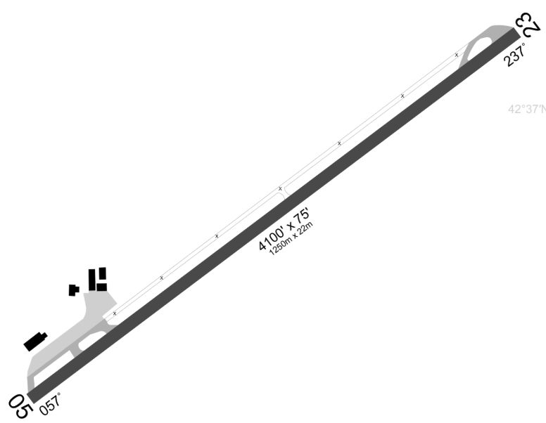
A 2025 airport diagram (courtesy of Andrew Thome) depicted Grand Geneva Airport as having a 4,100' paved Runway 5/23.

A 2025 photo by Andrew Thome of the Grand Geneva Airport airport office/barn.

The 2025 Sectional Chart (courtesy of Andrew Thome) depicted Grand Geneva Airport as having a 4,100' paved runway.

A 2025 aerial view by Andrew Thome looking west at the remains of Grand Geneva Airport.

A 4/3/26 photo by Andrew Thome of the mural at the Grand Geneva Airport showing their former airport at the base of their ski resort.
____________________________________________________
Beaver Dam Airport (1st location), Beaver Dam, WI
43.478, -88.835 (Northwest of Milwaukee, WI)
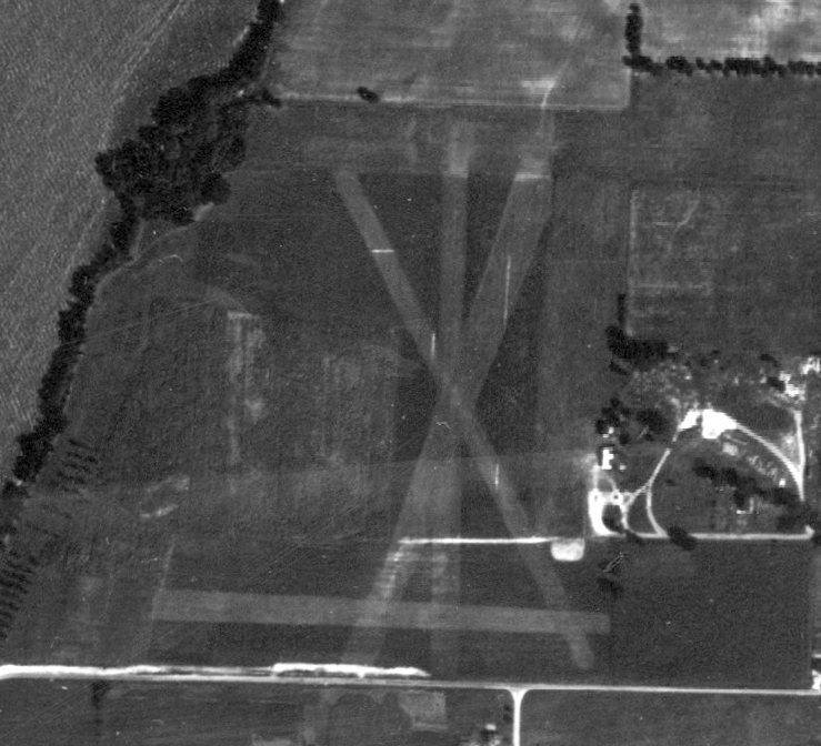
A 1940 aerial photo of the original Beaver Dam Airport (courtesy of Joe Wrzesinske).
The original airport for the town of Beaver Dam was located on the north side of the town.
The earliest depiction which has been located of Beaver Dam Airport was a 1940 aerial photo (courtesy of Joe Wrzesinske).
It depicted Beaver Dam Airport as having 4 unpaved runways, with some small buildings on the east side.
Beaver Dam Airport was not yet depicted on the 1941 Milwaukee Sectional Chart.

The earliest aeronautical chart depiction which has been located of Beaver Dam Airport was on the June 1942 Milwaukee Sectional Chart.
It depicted Beaver Dam as a commercial/municipal airport.

The last depiction which has been located of the original location of Beaver Dam Airport was on the December 1946 Milwaukee Sectional Chart.
It depicted Beaver Dam Airport as having a mere 1,500' unpaved runway.
The original Beaver Dam Airport was evidently closed (for reasons unknown) at some point between 1946-47,
as it was no longer depicted on the 1947 Milwaukee Sectional Chart.
A 1952 aerial photo did not show any recognizable traces of the original Beaver Dam Airport.

A 2023 aerial photo did not show any recognizable traces of the original Beaver Dam Airport.
____________________________________________________
Beaver Dam Airport (2nd location), Beaver Dam, WI
43.457, -88.864 (Northwest of Milwaukee, WI)
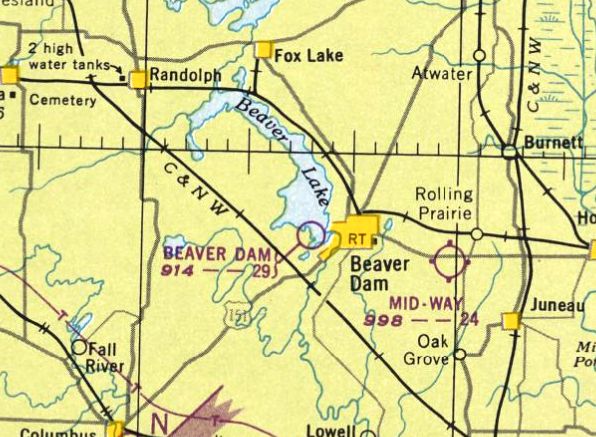
Beaver Dam Airport, as depicted on the December 1948 Milwaukee Sectional Chart.
No airfield at this location was yet depicted on a 1940 aerial photo.
The 2nd location of Beaver Dam Airport was evidently established at some point between 1947-48,
as it was not yet depicted on the 1947 Milwaukee Sectional Chart.
The earliest depiction which has been located of the 2nd location of Beaver Dam Airport was on the December 1948 Milwaukee Sectional Chart.
It depicted Beaver Dam as having a 2,900' unpaved runway.

The earliest topo map depiction which has been located of Beaver Dam Airport was on the 1955 USGS topo map.
It depicted Beaver Dam Airport as having 2 unpaved runways in an “X” shape, with a small building on the east side.

It depicted Beaver Dam Airport as having 2 unpaved runways in an “X” shape, with a dozen light aircraft & several T-hangars on the east side.

The last aeronautical chart depiction which has been located of Beaver Dam Airport was on the December 1966 Milwaukee Sectional Chart.
It depicted Beaver Dam as having a 2,400' unpaved runway.
Beaver Dam Airport was evidently closed (for reasons unknown) at some point between 1966-67,
as it was no longer depicted on the 1967 Milwaukee Sectional Chart.
A 1975 aerial photo showed that 3 of the Beaver Dam Airport T-hangars remained, but the runways had been returned to cultivation.

Beaver Dam Airport was still depicted on the 1976 USGS topo map, even though it had evidently ceased to operate nearly a decade before.

A 2023 aerial view looking northwest showed the site of the 2 location of Beaver Dam Airport remained clear, but with no specific remains of the airport.
Thanks to Joe Wrzesinske for pointing out this airfield.
____________________________________________________
Chaplin Airpark, Plymouth, WI
43.761, -87.986 (North of Milwaukee, WI)

Chaplin Airpark, as depicted on the December 1946 Milwaukee Sectional Chart.
Chaplin Airpark was not yet depicted on the June 1946 Milwaukee Sectional Chart.
According to DiscoverPlymouth, “After Harry Chaplin returned from World War II, his grandmother didn’t want him to leave the area since jobs were scarce.
So, she gave a part of the family farm to Harry to start an airport. It was a place that allowed Harry to continue using the skill he learned while in the Army Air Corps, airplane maintenance.
His father Harvey helped him build the hangars. In 1946, the airport was opened & running as Chaplin Airpark. The name was printed in large letters on the rooftop for pilots to see & know where the airport was.
The first plane the company owned was a Piper Cub. Many interesting people flew through the airport while doing business in the Plymouth area.
To keep the business running in the early years, Harry would take a flatbed truck out & pick up crashed aircraft & rebuild them, since the planes were made of wood & fabric.
There was one runway running east/west that consisted of mowed grass. Keeping the runway open & filling gopher holes were constant chores.
Flight instruction was another part of the business in addition to aircraft maintenance. Harry published the first general aviation statewide publication called The Badger Airway Beacon.
Harry was very active in helping to grow general aviation in Wisconsin & on the national level. He served as the president of the Wisconsin Aviation Trades Association.
He worked arduously to improve aviation business practices & devoted many uncounted hours toward the development of good, sensible, and fair legislation for the industry.”
The earliest depiction which has been located of Chaplin Airpark was on the December 1946 Milwaukee Sectional Chart.
It depicted Chaplin Airpark as having a 2,000' unpaved runway.

The last photo which has been located of Chaplin Airpark was a 1951 aerial view.
It depicted a single east/west grass runway, with 2 small buildings & 1 light single-engine plane on the south side.

The earliest topo map depiction which has been located of Chaplin Airpark was on the 1954 USGS topo map.
It depicted Chaplin Airpark as having a single east/west unpaved runway, with 2 small buildings on the south side.

The last aeronautical chart depiction which has been located of Chaplin Airpark was on the November 1960 Milwaukee Sectional Chart.
It depicted Chaplin as having a 2,200' unpaved runway.
According to DiscoverPlymouth, “The fixed base operation of Chaplin Airpark was moved to the Sheboygan County Memorial Airport when Harry was appointed manager of the new airport in the early 1960s.
The airport was closed in favor of a more centralized airport for Sheboygan County.”
Chaplin Airpark was no longer depicted on the May 1965 Milwaukee Sectional Chart.
A 1971 aerial photo showed houses had been built over the western portion of Chaplin Airpark, along a street named “Airpark Road”,
but the 2 small hangars remained on the south side.
A 1986 aerial photo showed Wisconsin Route 23 had been built over the northern portion of Chaplin Airpark at some point between 1981-86.

A 2022 photo looking east at the former Chaplin Airpark hangars, nicely modernized & reused by the “Other Place” business.

A 2023 aerial view showed houses & roads covering the majority of the Chaplin Airpark site, but the 2 former hangars remained on the south side.

A 2024 photo by Jake Schultz of a mural in Plymouth commemorating Chaplin Airpark.
Thanks to Jake Schultz for pointing out this airfield.
____________________________________________________
Vincent Airfield (64C), Genoa City, WI
42.519, -88.302 (Southwest of Milwaukee, WI)

Vincent Airfield, as depicted on the May 1960 Milwaukee Sectional Chart.
This small private airfield was evidently established at some point between 1959-60,
as it was not yet depicted on a 1956 aerial photo nor on the 1959 Milwaukee Sectional Chart.
Doug Rogers recalled, “Vincent Airfield... I lived next to it as a child & owe my career to it!”
The earliest depiction which has been located of Vincent Airfield was on the May 1960 Milwaukee Sectional Chart.
It depicted Vincent as a private airfield having a 2,200' unpaved runway.

The earliest topo map depiction which has been located of Vincent Airfield was on the 1960 USGS topo map.
It depicted a single east/west unpaved runway, generically labeled as “Landing Strip”.

The May 1970 Milwaukee Sectional Chart depicted Vincent as a private airfield having a 2,500' unpaved runway.
The earliest photo which has been located of Vincent Airfield was a 1971 aerial view.
It depicted Vincent as having an east/west grass runway, and a hangar & 1 light single-engine plane on the southwest side.
A 1976 aerial view did not depicted an aircraft at Vincent Airfield.
A 1980 aerial view depicted Vincent Airfield perhaps at the zenith of its popularity, with 8 aircraft parked on the southwest side.

The 1980 USGS topo map depicted “Vincent Landing Strip” as a single east/west runway.
A 1987 aerial view once again depicted Vincent Airfield devoid of aircraft.
Doug Rogers recalled, “In the late 1990s the hangar contained an Aeronca Champ, a Piper Cub, and a Cessna 195.”
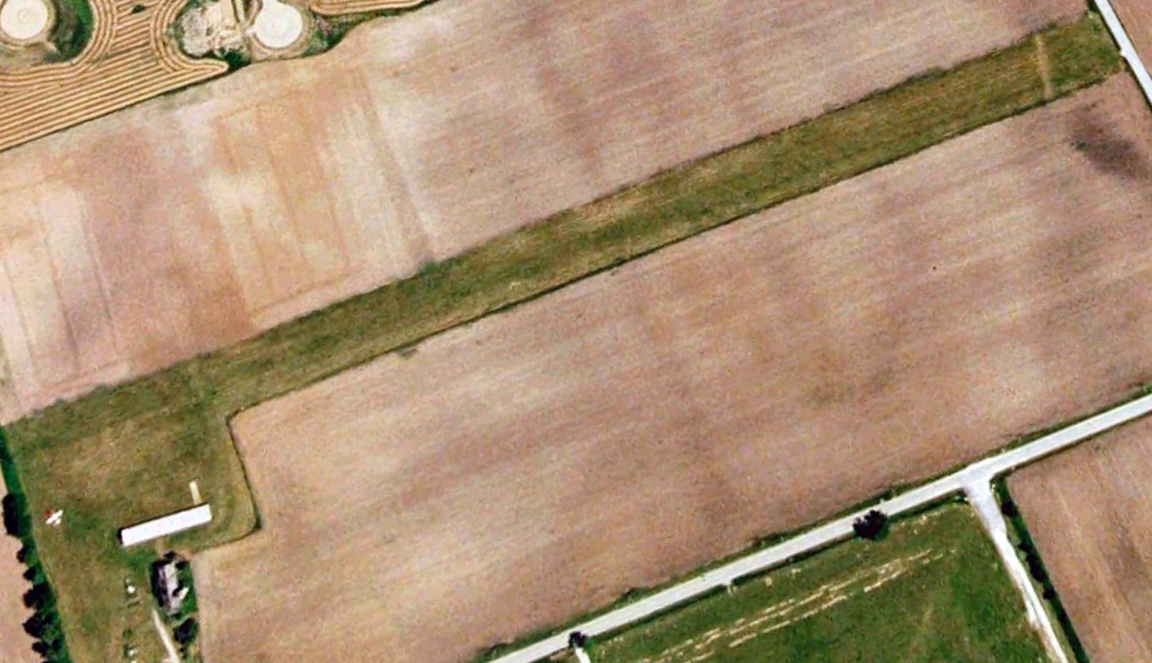
The last photo which has been located showing an aircraft at Vincent Airfield was a 2004 aerial view looking northeast, which showed 1 light single-engine aircraft on the southwest side.

A 2006 photo by Doug Rogers looking showed the Vincent Airfield runway to remain very well-maintained.

A 2007 aerial view looking northwest depicted Vincent Airfield as having an east/west grass runway, with a hangar on the southwest side, but there were no aircraft visible.
Doug Rogers recalled, “The last time I used the field was 2010.”
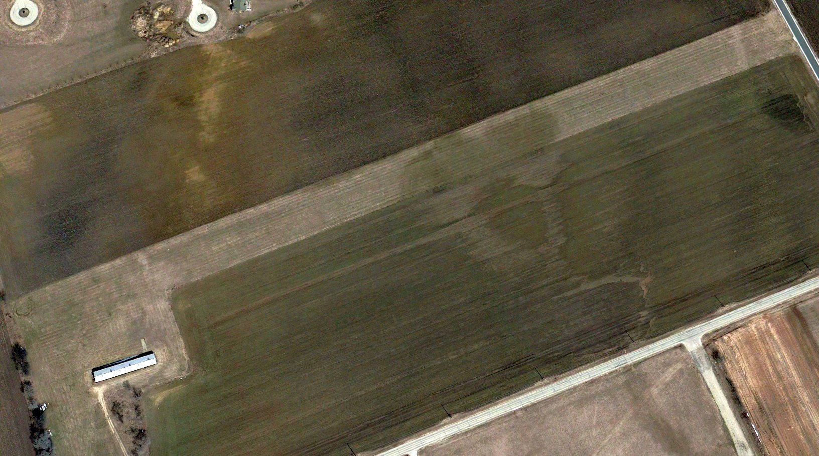
The last photo which has been located showing Vincent Airfield remaining intact was a 2013 aerial view looking northeast.
Doug Rogers recalled, “To my knowledge, the field was closed & turned under some time in 2014 after the death of the manager.”
A 2015 aerial view showed the Vincent Airfield runway had been removed, with a farm field covering the site.

The last aeronautical chart depiction which has been located of Vincent Airfield was on the 2019 Chicago Terminal Chart.
It depicted Vincent as a private airfield having a 1,800' unpaved runway.
This is an obvious safety hazard for the aeronautical charts to continue to show an airfield at least 4 years after it had been physically removed.

A 2021 aerial view looking northeast showed only the faintest trace remaining of the Vincent Airfield runway, with it having been plowed under. The hangar remained on the southwest side.

A 2022 photo looking north at the Vincent Airfield hangar.
Vincent Airfield was no longer depicted on 2023 aeronautical charts.
Doug Rogers reported in 2023, “The hangar still exists.”
Thanks to Doug Rogers for pointing out this airfield.
____________________________________________________
Westosha Airport (5K6), Wilmot, WI
42.514, -88.205 (Southwest of Milwaukee, WI)
Westosha Airport, as depicted on the May 1970 Green Bay Sectional Chart.
According to its FAA Airport/Facility Directory data, Westosha Airport was activated in September 1969.
The earliest depiction which has been located of Westosha Airport was on the May 1970 Green Bay Sectional Chart.
It depicted Westosha as a private airfield having a 2,600' unpaved runway.

The 1971 USGS topo map depicted Westosha Airport as a single unpaved east/west runway, labeled generically as “Landing Strip”,
with an unpaved taxiway leading to 3 small buildings on the southeast side.
The earliest photo which has been located of Westosha Airport was a 1971 aerial view.
It depicted Westosha as having a single unpaved east/west runway, with an unpaved taxiway leading to 3 small buildings on the southeast side,
around which were parked 7 light single-engine aircraft.
A 1980 aerial view showed Westosha Airport had gone thru a dramatic upgrade in 9 years.
The was no sign of the former unpaved east/west runway, with it having been replaced by a paved Runway 3/21 & an unpaved northwest/southeast runway.
The number of hangars on the south side had grown, and there were several dozen light aircraft parked outside.

The 1980 USGS topo map depicted “Westosha Landing Strip” in its new configuration, with a paved northeast/southwest runway.
A 1995 aerial view showed Westosha Airport had gained several more hangars, but the number of aircraft parked outside had decreased.
A 2000 aerial view showed Westosha Airport had declined once again in popularity,
with the number of aircraft visible outside having decreased to less than 10.

A 4/2302 USGS aerial view showed Westosha Airport as having a paved Runway 3/21 & an unpaved northwest/southeast runway.
A total of 15 light aircraft were visible on the field.

An August 2015 photo looking northeast along Westosha Airport's Runway 3, showing 3 single-engine Cessnas parked north of the hangar.
For a 1-year period ending 6/3/16, the FAA Airport/Facility Directory data described Westosha Airport as having conducted an average of 25 takeoffs or landings per day.

A circa 2016 3D aerial photo looking south at Westosha Airport, showing 9 single-engine Cessnas parked near the hangars.

The last photo which has been located showing planes at Westosha Airport was a 2017 aerial view looking north,
which showed 4 single-engine Cessnas parked near the hangars.
The end for Westosha Airport evidently came in 2018,
when its sole runway (3/21) was listed by NOTAM 06/375 as permanently closed effective 7/1/18.

A 2018 aerial view looking north showed Westosha Airport remaining intact, and with its runway still marked as active, but devoid of any planes.
Westosha Airport continued to be listed with the FAA as an active airport, even after its sole runway was permanently closed.
As of 2019, the FAA Airport/Facility Directory data described Westosha Airport as having 20 based aircraft.
It was said to have a 2,849' asphalt/concrete Runway 3/21, “in fair condition”.
Westosha Airport was listed as being owned by the Thelen Sand & Gravel Company, with the manager being Westosha Aviation Management.
Andrew Thome reported in 2019, “I was really looking forward to flying to it once I had received my Private Pilots License but have lost my chance.
A gravel company is going to mine the area. Sad.”
Westosha Airport continued to be depicted as an active airport on the 2019 Chicago Terminal Chart, shown to have a 2,800' paved northeast/southwest runway.
Since its sole runway has been permanently closed, continuing to depict Westosha as an active airport is contradictory, and a safety hazard
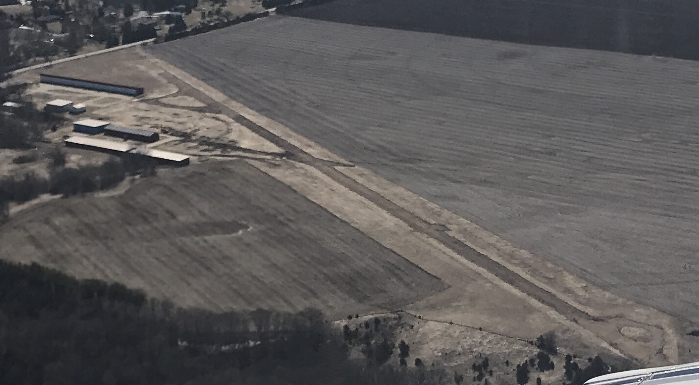
A 2019 aerial view looking southwest at Westosha Airport by Andrew Thome, who observed, “It looks like they ripped up most of the runway except the concrete at one end.”

A 2019 aerial view looking north at the Westosha Airport hangars by Andrew Thome.
What a shame to see this nice grassroots aviation infrastructure going to waste.
Thanks to Andrew Thome for pointing out this airfield.
____________________________________________________
Madison North Street Airport, Madison, WI
43.11, -89.351 (Northeast of Downtown Madison, WI)

Madison North Street Airport, as depicted on a 1930 Airway Chart.
An 8/22/27 photo of Charles Lindbergh landing the Spirit of St. Louis, his Ryan NYP at Royal Airport.
According to Micheal Goc's book “Forward in Flight – The History of Aviation in Wisconsin”, Madison North Street Airport was established in 1927
and located northeast of the intersection of North Street & Coolidge Street.
According to Al Hatz, “This is the airport Orland Corben ran & sold kits for the Corben Baby Ace, Super Ace and Junior Ace.”
The earliest depiction which has been located of Madison North Street Airport was on a 1930 Airway Chart.
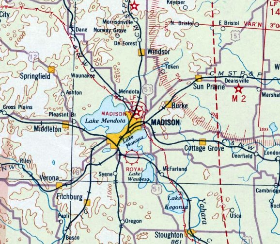
Madison North Street Airport, as depicted on the June 1931 Milwaukee Sectional Chart.

A circa 1930s photo of a row of biplanes in front of a Madison Airport hangar & beacon tower (courtesy of Al Hatz).

A circa 1930s photo of a Corben Baby Ace at Madison North Street Airport (courtesy of Al Hatz).

A 7/6/37 aerial view (courtesy of Al Hatz) depicted Madison North Street Airport as having a rectangular grass airfield,
with a hangar & 3 light planes on the south side.
The much larger Madison Municipal Airport / Truax Field was opened a few miles to the northeast in 1937,
which would eventually replace North Street Airport.

The last aeronautical chart depiction which has been located of Madison North Street Airport was on a September 1941 Milwaukee Sectional Chart.
Madison North Street Airport was evidently closed at some point between 1941-42,
as it was no longer depicted on the June 1942 Milwaukee Sectional Chart.

A 2014 aerial view showed no trace remaining of North Street Airport.
Thanks to Al Hatz for pointing out this airfield.
____________________________________________________
(Original) Fond du Lac Airport, Fond du Lac, WI
43.788, -88.414 (Northwest of Milwaukee, WI)

A 1937 aerial view of Fond du Lac Airport Airport (from the WI Historic Aerial Imagery Finder, courtesy of Al Hatz).
The original airport for the town of Fond du Lac was located on the east side of the town.
The date of establishment of Fond du Lac Airport has not been determined.
The earliest photo which has been located of Fond du Lac Airport was a 1937 aerial view (from the WI Historic Aerial Imagery Finder, courtesy of Al Hatz).
It depicted Fond du Lac as having 2 perpendicular grass runways, with a hangar & 1 light single-engine aircraft on the southeast side.

A 9/19/40 aerial view (courtesy of Lee Corbin) looking northeast at the Fond du Lac Airport
depicted an arch-roofed hangar (with “Fond du Lac Airport” painted on the roof) & a terminal building alongside a grass airfield.
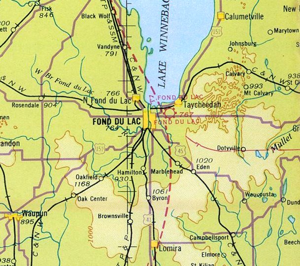
The earliest aeronautical chart depiction which has been located of Fond du Lac Airport was on the June 1942 Milwaukee Sectional Chart.
It depicted Fond du Lac as a commercial/municipal airport.

A circa 1940s photo looking north at the Fond du Lac Airport hangar (with windsock on top) (courtesy of Nicole Blatz of the C. D. Smith Company),
along with the Charles D. Smith Company building in the foreground .

A 12/4/51 aerial view (courtesy of Lee Corbin) depicted Fond du Lac Airport as having 3 unpaved runways,
with a few small buildings on the southeast side.

The last aeronautical chart depiction which has been located of Fond du Lac Airport was on the May 1953 Milwaukee Sectional Chart (courtesy of Ron Plante).
It depicted Fond du Lac Airport as having a 2,80' unpaved runway.

The 1955 USGS topo map depicted Fond du Lac Airport as having a paved north/south runway,
an unpaved northwest/southeast runway, and 3 small buildings on the southeast side.
The larger Fond du Lac County Airport was opened to the west of the town in October 1958,
at which point the original Fond du Lac Airport was evidently closed.
John Potter recalled, “I was born in Fondy in 1959 & my parents had built a home on a dead-end street at the West end of the old airport.
Dad worked for Hopmans at A.F. Klinzing Company (farm equipment) who had moved into the old airport building & shared the north side with a concrete drain line supplier.
Dad use to drive on the weed-covered runway to shortcut to work. Dad's office was the 3rd window from the right of the office entrance.”

A circa 1963 photo of the staff of the A.F. Klinzing Company (including C.E. Potter on the right)
in front of “the old hangar at the former Fond du Lac County Skyport” (courtesy of John Potter).
The 1985 USGS topo map depicted streets & new buildings having covered a majority of the original Fond du Lac Airport site.

A circa 1990s photo of the original Fond du Lac Airport hangar (courtesy of Nicole Blatz of the C. D. Smith Company),
with the airport name still visible though faded on its roof.

A circa 2010-2017 photo looking southeast at a former hangar on the southeast corner of the site of the original Fond du Lac Airport (courtesy of Lee Corbin).
Lee Corbin reported, “I verified with the CEO of the C.D. Smith Company that their building is the old hangar.”

A circa 2010-2017 aerial view looking east at the former hangar on the southeast corner of the site of the original Fond du Lac Airport (courtesy of Lee Corbin).
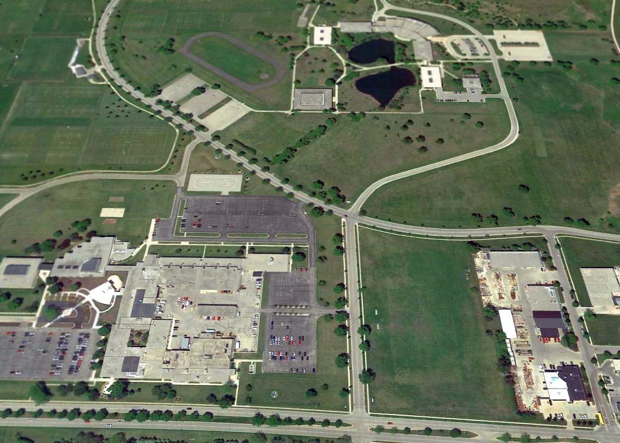
A 2015 aerial view looking north at the site of the original Fond du Lac Airport, with the former hangar remaining at the southeast corner (bottom-right).

A July 2019 photo looking southeast at a former hangar on the southeast corner of the site of the original Fond du Lac Airport, reused by the C.D. Smith Construction company.
The site of the original Fond du Lac Airport is located northwest of the intersection of State Route 23 & Prairie Road.
Thanks to Lee Corbin for pointing out this airfield.
____________________________________________________
Janesville City Airport, Janesville, WI
42.712, -89.01 (West of Milwaukee, WI)

A circa 1929 photo (courtesy of Geoffrey Parker) of Parker Pen’s first plane (a Fairchild FC-2W2) & Kenneth Parker's Fleet Model 1 at the Janesville City Airport.
According to Geoffrey Parker, “Janesville’s first airport was known as Janesville City Airport.
It was located on the northern fringe of town just west of Highway 26, bordered approximately by Kennedy Road to the east & Black Bridge Road to the south.
The earliest photo which has been located of Janesville City Airport was a circa 1929 photo (courtesy of Geoffrey Parker)
of Parker Pen’s first plane (a Fairchild FC-2W2) & Kenneth Parker's Fleet Model 1.
According to Geoffrey Parker, “A journal kept by my grandfather [Kenneth Parker], an active pilot, said:
'The field had been in use for at least 2 years before [1930].'”

A circa 1930 photo (courtesy of Lee Corbin) of an aircraft race held at Janesville City Airport, with large numbers of spectators.

A circa 1930 photo (courtesy of Geoffrey Parker) of Janesville City Airport.
According to Geoffrey Parker, “This photo probably shows the official opening, if not of the airport then of the hangar.
The airport was officially opened on 8/9/30.”
Camy Matthay reported, “The Janesville Airport... I am 99% sure that my father [Frank Matthay] was at the opening of the hangar,
and that he also kept his own plane (a Stearman Cloudboy) at the Janesville Airport in the 1930s.”

The earliest aeronautical chart depiction which has been located of Janesville City Airport was on the June 1931 Milwaukee Sectional Chart.
It depicted Janesville City as a commercial/municipal airport.
Geoffrey Parker continued, “My grandfather’s Stinson was personally delivered to the City Airport by Eddie Stinson.
Probably the biggest airport event was when Wiley Post & Harold Gatty flew in on 8/9/31.
They stayed at my grandfathers house & after delivering a local radio speech that evening left the following day.
This was only several weeks after their famous flight around the world.
Air mail service began during 1931: I believe that Northwest Airlines carried the mail.”
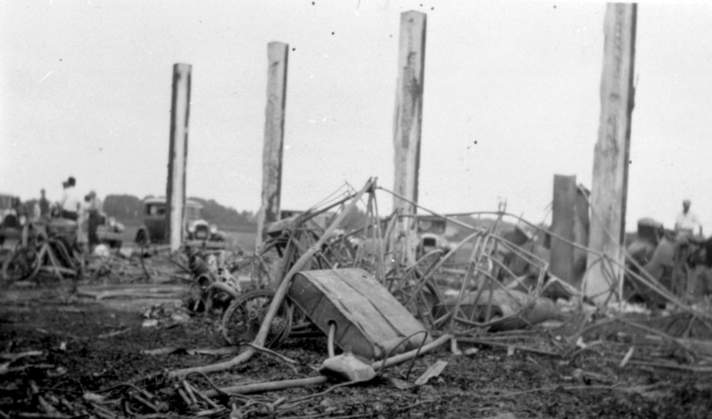
A 6/29/32 photo (courtesy of Geoffrey Parker) of the remains after the Janesville City Airport hangar fire.
Geoffrey Parker observed, “I assume that [my grandfather's] Stinson’s remains are in the foreground.”
Geoffrey Parker continued, “Airport boundary lights were first in use in August, 1932.
For most of that time there was, I believe, a single building.
That building was destroyed in a fire in 1933; it was deemed 'suspicious' as there was an ongoing disagreement
related to the 'milk wars' wherein anyone who sold milk for less than an agreed price might be punished - the owners were apparently doing just that.
All of the planes kept in the hangar were destroyed; my grandfather’s Stinson SM-8A Junior among them.
Eventually another hangar replaced it. And later a second private hanger housing Parker Pen’s plane (then a Cessna T-50 Bobcat) was built.
Not too long after that Parker moved to the current JVL field.”

A 7/26/37 USDA aerial view of Janesville City Airport (from the WI Historic Aerial Imagery Finder)
depicted the field as having 3 unpaved runways & a hangar on the southeast side.

The June 1942 Milwaukee Sectional Chart depicted Janesville as a commercial/municipal airport.

A circa 1942-45 aerial view looking north in the 1945 AAF Airfield Directory (according to Scott Murdock)
depicted Janesville City Airport as having 4 unpaved runways, with several hangars on the southeast side.
The 1945 AAF Airfield Directory (courtesy of Scott Murdock) described Janesville Airport as a 100 acre rectangular property having 4 sod runways, the longest measuring 2,600' northwest/southeast,
The field was said to have a single 80' x 52' metal hangar, and to be owned & operated by private interests.

A circa late 1940s – early 1950s aerial view looking south (courtesy of Geoffrey Parker)
depicted Janesville City Airport as having 4 unpaved runways, with several hangars on the southeast side.

The last aeronautical chart depiction which has been located of Janesville City Airport was on the May 1953 Milwaukee Sectional Chart (courtesy of Ron Plante).
It depicted Janesville City Airport as having a 2,300' unpaved runway.
Note that it also depicted the larger Rock County airport south of the town, which would soon replace Janesville City Airport.

The last photo which has been located of Janesville City Airport was a 4/17/55 USGS aerial view.
It depicted Janesville City Airport as having 4 unpaved runways, with several hangars & 4 light single-engine aircraft on the southeast side.
Janesville City Airport presumably closed at some point between 1955-58, as it was no longer depicted on the 1958 USGS topo map.
A 1992 aerial photo showed no trace remaining of Janesville City Airport, with the site having become an industrial park.

A 2014 aerial view showed no trace remaining of Janesville City Airport.
The site of the original Janesville Airport is located northwest of the intersection of Kennedy Road & Foster Avenue.
Thanks to Geoffrey Parker for pointing out this airfield.
____________________________________________________
Royal Airport / Pennco Field / Four Lakes Airport, Monona, WI
43.045, -89.35 (Southeast of Madison, WI)

An 8/22/27 photo of Charles Lindbergh landing the Spirit of St. Louis, his Ryan NYP at Royal Airport.
According to bloomingrovehistory.org, “The airfield known originally as Pennco Field was created from part of the McCauley farm,
located between the Dane Country Fairgrounds & the Yahara River. It was later named Royal Airport.
Howard Morey made a forced landing in a field near Madison in December,1925.
He called his wife's cousin, E. N Quinn, who drove out to get him & help tie down the plane.
Morey taught Quinn to fly & together they operated a business including landing field & hangars, flying schools, and aeronautical stunt shows.
Later they established the first regular commercial air traffic from Wisconsin to Chicago and regular contract air mail service for Madison.
The first hangar was built in 1926 by Madison Airways Co.
It was a Trachte company metal building, 100' wide, that could shelter 17 planes.”
According to bloomingrovehistory.org, “Royal Airways Corporation formed in 1927.
Quinn & Don Anderson, publisher of the Wisconsin State Journal, persuaded Colonel Charles Lindbergh to come to Madison”,
only 3 months after his triumphant transatlantic flight.
The earliest depiction of Royal Airport which has been located
was an 8/22/27 photo of Charles Lindbergh landing the Spirit of St. Louis, his Ryan NYP at Royal Airport.
This stop was one of only 2 appearances made in Wisconsin during Lindbergh's triumphant national tour.

A 1927 photo of Lindbergh's famous Spirit of St. Louis Ryan monoplane inside a hangar at Royal Airport.
According to bloomingrovehistory.org, “On 11/23/27, airmail contract service was inaugurated in Madison,
with the first flight leaving Royal Airport carrying 15,000 letters.”

A 1928 aerial view of Royal Airport apparently taken during some kind of event, with hundreds of spectators.
The field consisted of an open grass area with a hangar along one side.

A 1928 aerial view of Royal Airport apparently taken during some kind of event, showing 3 hangars & one monoplane.

A 1928 photo of a Waco biplane (model undetermined) taking up 2 passengers from Pennco Field.

A 4/17/28 photo of an "American Girl" movie group & a pilot in front of a Waco biplane marked “Royal Airways Corp.” at Royal Airport.
The earliest aeronautical chart depiction which has been located of Royal Airport was on a 1930 Airway Chart.

A 1930 aerial view of a Royal Airport hangar, surrounded by hundreds of spectators, with 7 planes on the field.
Royal Airport, as depicted on the June 1931 Milwaukee Sectional Chart.

A 1932 photo of an Hamilton H-47 Metalplane (identified by H.G. Frautschy) in front of a Royal Airport hangar.

The last aeronautical chart depiction which has been located of Royal Airport was on a 1935 Regional Aeronautical Chart.

A 6/27/37 USDA aerial view of Royal Airport (from the WI Historic Aerial Imagery Finder)
depicted the field as having an unpaved north/south runway, with an airport circle marking at the north end.
Four light single-engine aircraft were parked near a hangar & some T-hangars on the west side,
and a larger aircraft was parked near a paved ramp on the north side.
According to bloomingrovehistory.org, “A few years later the advent of the large transport planes made Royal's facilities inadequate,
and the City of Madison purchased 290 acres north of the city.
Difficulties in developing the marshy area during the depression caused Madison to suspend efforts there.
So the city leased Royal Airport for its municipal field for $2,000 per year, and provided lighting & improvements.
Royal Airport continued to serve Madison until 1938 when the new Municipal Airport was finally completed & opened with Howard Morey as manager.”
According to Mark Hess, Royal Airport was “used by the Civil Air Patrol from 1942-45.”

The last photo which has been located of Royal Airport was a circa 1942-45 aerial view looking north in the 1945 AAF Airfield Directory (according to Scott Murdock).
The directory described Royal Airport as a 135 acre L-shaped property having 2 loam & sod runways, measuring 3,000' north/south & 2,800' east/west.
The field was said to have 5 metal hangars, the largest measuring 60' x 50', and to be owned & operated by private interests.
According to Mark Hess, Royal Airport was “closed sometime in the mid- to late-1940s.”

The airport evidently reopened at some point between 1945-52 under the name of Four Lakes,
as that is how it was depicted on the November 1952 Milwaukee Sectional Chart, with a 2,700' unpaved runway.
Four Lakes Airport evidently closed (for reasons unknown) at some point between 1952-55,
as it was no longer depicted on the 1955 USGS topo map.
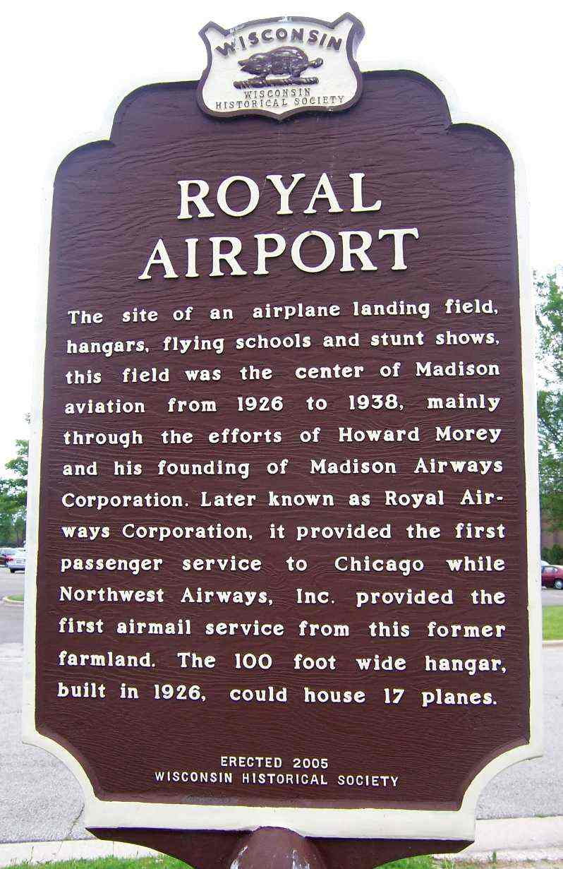
A circa 2005-2012 photo of a historical marker at the site of Royal Airport.

A 9/27/10 aerial view showed no trace remaining of Royal Airport.
H.G. Frautschy reported in 2012, “I was helping one of our board members take a few pieces of useful material
from a project to repurpose a movie theater on the south side of Madison,
and only after the work was done did I realize that the property was on the grounds of the old Royal Airport.”
The site of Royal Airport is located southwest of the intersection of South Towne Drive & Frazier Avenue.
____________________________________________________
Hales Corners Airport, Hales Corners, WI
42.928, -88.043 (Southwest of Milwaukee, WI)

A November 1947 photo of 2 Vultee BT-13 Valiants at a snowy Hales Corner Airport (courtesy of David Faige).
This general aviation airport was evidently established at some point between 1946-47
(like hundreds of other airports in the post-WW2 aviation boom),
as it was not yet listed among active airfields in the 1945 AAF Airfield Directory (according to Scott Murdock)
nor depicted on the June 1946 Milwaukee Sectional Chart (courtesy of Jim Stanton).
The earliest depiction of Hales Corner Airport which has been located
was a November 1947 photo (courtesy of David Faige) of a Vultee BT-13 Valiant & a North American AT6 Texan, with snow on the ground.
The original name of the airport may have been “Skyway”, as that was the hand-written caption on the photo.

The earliest aeronautical chart depiction which has been located of Hales Corners Airport was on the May 1950 Milwaukee Sectional Chart.
It depicted Hales Corners as having a 2,100' unpaved runway.
Reportedly the first EAA fly-in was held in 1953 in Hales Corners,
and the EAA Museum was located in the town (but evidently not at the airport) for several years.
Carolyn (Gardner) Wiars reported, “My daddy use to own the Hales Corners Airport – 1950s (Al & Vi Gardner).
I learned to fly before I received my driver’s license.
I was the youngest female pilot in Wisconsin in the 1950s that attended the Breakfast Fly In 7/18/54
at the Dawn Patrol Breakfast, sponsored by Flint’s Civil Air Patrol.
Audrey & Paul (Howard) Poberezny, from the Experimental Aircraft Association used to fly out of my Dad’s airport,
and attend lots of parties in the hangars of the airport with many others.”

A 4/8/55 USGS aerial photo depicted Hales Corners Airport as having 3 unpaved runways, with several small hangars & 4 single-engine aircraft on the west side.
Bob Kacmarcik recalled, “The east/west runway paralleled the tree line. The northwest/southeast runway was rarely used.
The object to to east of the intersecting runways was a little shelter that when the Sky Knights were jumping, was used as a recovery point.
They would wait for all the jumpers to land, carry their gear to the little building then be driven back to the large building pictured behind the Cessna 182 jump plane where their parachutes would be repacked.
The Sky Knights parachute club began at Hales Corners, started by Jeff Searles.”

Hales Corners Airport, as depicted on the 1958 USGS topo map.

The 1959 USGS topo map depicted Hales Corners Airport as having 2 perpendicular unpaved runways, with several small buildings along the west side.
Larry Palmersheim recalled, “Hales Corners Airport... I grew up on the farm immediately north of this airport.
I lived there from 1959-71, and my mother continued to live there until this past September [2011].
There were 2 runways used, the main east/west runway & a secondary, little-used northeast/southwest runway
which began at the edge of Whitnal Park (east extent) and merged with the east/west runway like a crooked Y.
A narrow strip of trees separated these runways on the eastern aspect.
College avenue (not Kay Parkway) formed the northern border of the airport.
The EAA facility was located in a small building between Highway 100 (the west border of the airport) and Highway OO.
Access was from Highway OO.
The office was a Quonset hut located approximately 75 yards from Highway 100
(west border which currently would be just north of Pick & Save) just north of the runway.”
Larry continued, “At the split between the east/west & northeast/southwest runways was a junked T-6.
If us kids would try to sneak out to it invariably someone would come charging in a car to chase us away.
For several years in the 1960s the northeast/southwest runway would be used for skydiving.
My father would become quite upset with errant parachutists landing in his beanfield.
One fall we recovered a reserve parachute from the field which I have to this day.
In the early 60s a ride in the T-6 Texan would cost $10 for 10 minutes. I never did this but to this day wish I had.
Early RC [radio-controlled model aircraft] enthusiasts would also use this secondary runway space to fly their planes, in the 1960s.
I would often ride my bike down to watch them.”

Hales Corners Airport, as depicted on a circa 1960 road map (courtesy of Kevin Walsh).
Bob Kacmarcik recalled, “I would ride my bike to the Hales Corners Airport.
The airport's main entrance was at what is now apartments at roughly 6420 S 108th St, Franklin,
though just behind the Schoolway School Bus Company grounds; the airport did extend to the north & College Avenue.
Christmas of 1960 my favorite gift from Santa was a Kodak Kodex #1 bellows camera that took black & white 620 film.
After doing my school work & duties at home, off I would go to the airport on my bike with my new camera.
My Mother’s cousin, Al Svoboda, was the Fixed Base Operator at Hales Corners!
I ended up being the excited 14 year old cutting the grass, fueling aircraft, cleaning windshields of bugs, wiping oil from the underside of cowlings, selling sectional charts & candy bars.
Uncle Al never paid me for my hard work, but he took me flying instead.
I learned in later years, that Uncle Al was doing the test flying of many aircraft that Chris,
the Airframe & Powerplant Mechanic on the field, had just repaired, so I logged instruction in MANY different aircraft of the day.
The Hales Corners airport played an important part in the beginnings of the EAA with Paul Poberezny having an office on the field
and the earliest EAA museum in a Quonset hut on the Northeast corner of W Rawson Avenue & North Cape Road.
Some of my best memories are of those days.”

A March 1961 photo by Bob Kacmarcik of planes & hangars to the west of the main Quonset hangar at Hales Corners Airport.

A March 1961 photo by Bob Kacmarcik of a North American T-6 Texan warbird at Hales Corners Airport.

A 1963 photo by Bob Kacmarcik of a 1956 Cessna 182 parachute jump plane at Hales Corners Airport.
Bob Kacmarcik recalled, “The large building pictured behind the Cessna 182 jump plane [is] where their parachutes would be repacked & do their pre-jump check list.
The steep-roofed building behind the 5729B numbers on the 182 is our Fixed Base Operator office; it was an old gas station office & moved to the airport.
That is where I would ring up gas & oil sales... sell sectionals & candy bars & just provide a place for pilots and passengers who were passing through or had airplanes based at Hales Corners.”

A circa 1963 photo by Bob Kacmarcik of a an Ercoupe in front of a Hales Corners Airport Quonset hut.
Bob Kacmarcik recalled, “That is one of the first airplanes Uncle Al taught me to fly.
In fact, on one of our first flights, he fell asleep when we were maybe 200' in the air.
I flew around the countryside for an hour or so. He did wake up when I was on final approach to Runway 9 back at Hales Corners, and yes, I did miss the high tension wires, Wink.”

A circa 1963 photo by Bob Kacmarcik of a a Hughes 269 or 300 helicopter at Hales Corners Airport.

A 1963 photo by Bob Kacmarcik of spectators watching a skydiver land at Hales Corners Airport.

A May 1963 photo by Bob Kacmarcik of a Civil Air Patrol Cessna 140 in front of the lane at Hales Corners Airport main meeting building & parachute repacking shop.
A 1963 aerial photo depicted Hales Corner Airport as having a single grass east/west runway,
with 18 light aircraft parked around a few small buildings on the northwest side.

The December 1965 Milwaukee Sectional Chart (courtesy of Ron Kunse) depicted Hales Corners Airport as having a 2,100' unpaved runway.
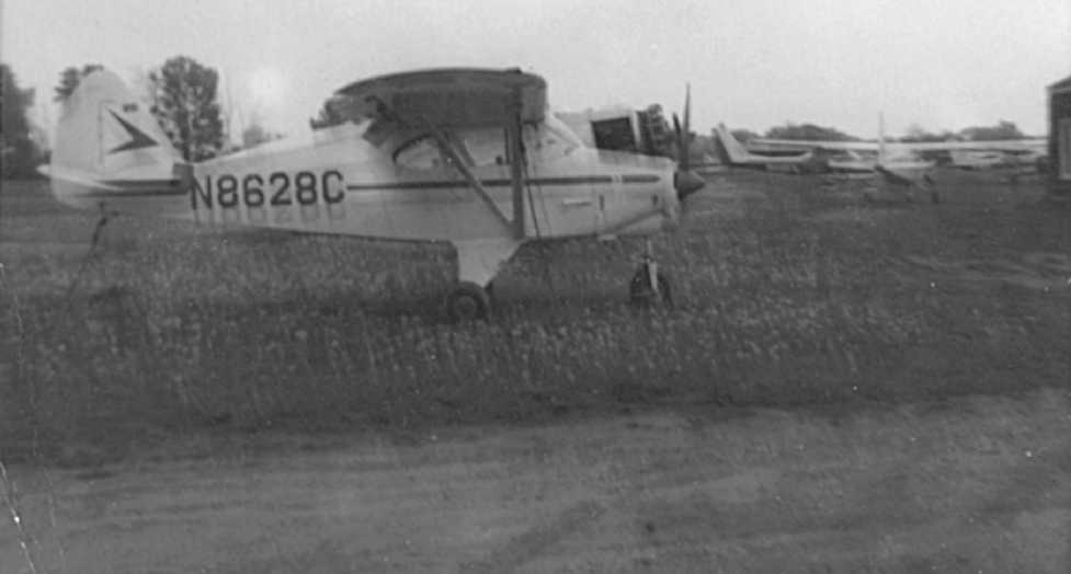
A 5/30/68 photo of a Piper Tri-Pacer & a few Cessnas at Hales Corners Airport (courtesy of David Faige).
David recalled, “It was at Hales Corners Airport that I got my first ride in an airplane (5/30/68).
I believe the Cessna 150 in the background was the aircraft that I had my first flight in.
The airport had a grass field & a Quonset-like structure for a hangar.”
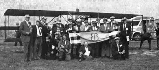
The last ground-level photo which has been located of Hales Corners Airport was a 1969 photo of the “Early Birds” standing in front of a 1912 Curtiss plane.
Jack recalled, “I learned to fly out of Hales Corners Airport, [in the] early 1970s.
In the spring the field would flood from melting snow & puddling in the middle of the east/west 2,000' grass runway.
There was a big dip in the center of the runway. So he would move the planes to Mitchell Aero (MKE) for a few weeks.
The other runways were not used anymore at that time. I also remember that when you took off to the west, you had to clear some high voltage power lines.
In the hot summer days this could be a little hairy (even worse at night).
People would also fly in for the day and walk to the EAA museum across the street. This is before they (EAA) moved to Oshkosh.
Lots of memories at that quiet little airfield.”

The last photo which has been located of Hales Corners Airport was a 3/1/76 USGS aerial view, which showed 10 light aircraft parked on the west side.

The last aeronautical chart depiction which has been located of Hales Corners Airport was on the May 1977 Chicago Sectional Chart (courtesy of John Ferrara).
It depicted Hales Corners as having a 2,000' unpaved runway.
According to Jack, Hales Corners Airport “closed in August 1977. At the time it closed, a guy had 3 Cessna 150s (N4054J, N63157, and 7809F) that he would rent out, $12/hour wet.
He had a lease to run the airport, but the owner sold the land to a developer & the airport was no more. ”

Hales Corners Airport was still depicted on a 1978 street map (courtesy of David Faige).
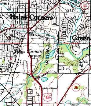
The last depiction which has been located of Hales Corners Airport was on the 1978 USGS topo map.
It depicted Hales Corners as having a single east/west runway.
Hales Corners Airport was no longer depicted on the 1980 USGS topo map
or the May 1985 Chicago Sectional Chart (courtesy of Jonathan Westerling).
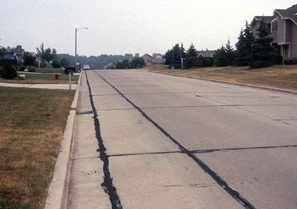
A June 1995 photo by David Faige looking ESE at College Avenue, the site of Hales Corner Airport.
According to Larry Palmersheim, “Our farmhouse, where my mother lived until October 2011, would be just 50' to the left of the curb on the bottom.
The main east/west runway would have been approximately 125-150 yards south of this road.”

A 7/29/11 aerial view showed no trace remaining of Hales Corners Airport.
According to Larry Palmersheim, “The main east/west runway would have been between the townhouse development at the top of the photo & the adjacent development below it.”
The site of Hales Corners Airport is located southwest of the intersection of Route 45 & Whitnall Edge Road.
____________________________________________________
Or if you prefer to contact me directly concerning a contribution (for a mailing address to send a check),
please contact me at: paulandterryfreeman@gmail.com
If you enjoy this web site, please support it with a financial contribution.
____________________________________________________
This site covers airfields in all 50 states.