Abandoned & Little-Known Airfields:
Eastern New Jersey
© 2003, © 2026 by Paul Freeman. Revised 3/2/26.
This site covers airfields in all 50 states: Click here for the site's main menu.
____________________________________________________
Please consider a financial contribution to support the continued growth & operation of this site.
Asbury Park Airport (revised 9/23/24) - Camp Alfred Vail Army Airfield / Fort Monmouth Army Airfield (added 9/9/20) - Colts Neck Airport (revised 2/15/25)
Ocean County Airport / Huppert’s Airport / Osbornville Airport (revised 10/27/19) - Red Bank Airport (revised 3/2/26)
Schlossbach Field / Asbury Park Neptune Air Terminal (revised 2/27/26) - Shore Airport (added 6/8/25)
____________________________________________________
40.117, -74.076 (South of New York, NY)
Shore Airport, as depicted on the April 1933 NY Sectional Chart.
Shore Airport was evidently established at some point between 1932-33,
as it was not yet depicted on the August 1932 NY Sectional Chart.
The earliest depiction which has been located of Shore Airport was on the April 1933 NY Sectional Chart,
which depicted Shore as an auxiliary airfield.

A postmark commemorated the 7/29/33 Official Opening of Shore Airport (courtesy of Joe Doherty).

A circa 1930s advertisement for Shore Airport featured an undated photo of a man in front of an unidentified biplane (courtesy of Joe Doherty).

The last depiction which has been located of Shore Airport was on the December 1935 NY Sectional Chart,
which depicted Shore as commercial/municipal airport.
Shore Airport was evidently closed at some point between 1935-36,
as it was no longer depicted on the June 1936 NY Sectional Chart.
It was presumably a victim of the Great Depression.
A 1940 aerial photo depicted the Shore Airport site as having been excavated.

The 1947 USGS topo map (annotated by Joe Flaherty) still depicted the property outline of Shore Airport, along with several buildings, but did not label the airport.
The 1957 USGS topo map labeled the Shore Airport site as a “Borrow Pit”.
A 2002 aerial view showed houses having covered the Shore Airport site.

A 2025 aerial view showed no trace remaining of Shore Airport.
Thanks to Joe Doherty for pointing out this airfield.
____________________________________________________
Asbury Park Airport, Oakhurst, NJ
40.259, -74.051 (South of New York, NY)

A 7/20/41 photo of an air show at Asbury Park Airport (courtesy of Stewart Agreen).
Asbury Park Airport was one of two closely-located small general aviation airports with similar names, the other being Asbury Park Air Terminal a few miles to the southwest.
No airfield was yet depicted at this location on a 1931 aerial photo.
The earliest reference which has been located to Asbury Park Airport was an article entitled “Asbury Has Airport” in the 6/30/32 Long Branch Daily Record (courtesy of Stewart Agreen), which read:
“The Asbury Park Airport Inc., to engage in passenger service, has been incorporated with a capitalization of $125,000.
The Incorporators are Joseph Johnon, Jennie Zambrano, and Josephine Lista.”
However their plans to open Asbury Park Airport may not have come to fruition in the 1930s, presumably due to the Great Depression,
as Asbury Park Airport was not depicted on 1930s NY Sectional Charts.
The first indication which has been located of Asbury Park Airport's opening was an article entitled “New Airport Starts by Two Shore Men” in the 10/10/39 Asbury Park Press (courtesy of Stewart Agreen), which read:
“William Sullivan & Alfred Morton today announced the opening of the Asbury Park Airport Inc. flying server at a new airfield on Route 35 at West Park Avenue & Deal Road.
William Parish & Gush Michelson, of the Aero Ad Corporation, will act as instructors.
The firm is now building a 90' x 60' hangar on the field which is situated at Wertheim's Corner.
They plan to teach flying to students as well as provide planes & fliers for charter trips.”
The earliest depiction which has been located of Asbury Park Airport was a 1940 aerial view.
It depicted a single north/south unpaved runway, with 2 small buildings & 1 light single-engine aircraft on the south side.
The first depiction which is available of Asbury Park Airport was a 7/20/41 photo of an air show, published in the 7/21/41 Asbury Park Press (courtesy of Stewart Agreen).
The article entitled “Air Show Nets Fund of $771 to Aid USO”, read:
“Thousands at Asbury Airport to see parachute jumps, stunt flying in 4 hour show.
Autos lined every side of the airport field, located west of Route 35 on the south side of West Park Avenue.”
Bruce Reid recalled, “I remember being at Asbury Airport when I was 4 years old. I saw biplanes & autogiros.
Living only about 2 miles south, I remember watching the autogiros flying nearly over our house many times with the 4-bladed rotary-wing, stubby wings & radial engine.”

The earliest aeronautical chart depiction which has been located of Asbury Park Airport was on the January 1947 NY Sectional Chart.
It depicted Asbury Park as a commercial/municipal airport,
along with the Asbury Park “Air Terminal” only a few miles to the southwest.

A advertisement in the July 1947 Asbury Park Press (courtesy of Stewart Agreen) touted the flight school & flight sales at Asbury Park Airport.
Stewart Agreen noted, “This advertisement can be found many times for several years in the Asbury Park Press.”
The last aerial photo which has been located of Asbury Park Airport was a 1947 aerial view.
The airfield configuration remained the same as seen in 1940, but the number of light single-engine aircraft parked on the south side had increased to five.

The last photo which has been located of Asbury Park Airport was a 7/31/49 photo of a crowd at a day-long airshow from the 8/1/49 Asbury Park Evening Press (courtesy of Stewart Agreen).
It pictured a Republic SeaBee amphibian in front of 2 hangars & a large oil storage tank.
Stewart Agreen noted, “I question the wisdom of putting large tanks of oil adjacent to a runway with flying machines!”
Asbury Park Airport still was not depicted on the 1949 USGS topo map.
Stewart Agreen reported he found no more newspaper advertisements for Asbury Park Airport after 1949.

The last depiction which has been located of Asbury Park Airport was on the January 1950 NY Sectional Chart.
An article in the 10/8/50 Asbury Park Press (courtesy of Stewart Agreen) said the Shore Gas & Oil Corporation announced construction of 2 new fuel storage tanks at the Asbury Park Airport had been completed.
Asbury Park Airport was evidently closed (for reasons unknown) at some point in 1950,
as it was no longer depicted on the July 1950 NY Sectional Chart.
An article in the 10/29/50 Asbury Park Press (courtesy of Stewart Agreen) said the Shore Gas & Oil Corporation had transferred their offices “to the former site of the Asbury Park Airport”,
including using the former airport office as their new company office.
A 1957 aerial photo showed 4 circular oil tanks on the south side of the Asbury Park Airport site.
The 2 former hangars remained, and the area of the former runway remained clear.
A 1979 aerial view showed the majority of the Asbury Park Airport site remained clear.
A 1985 aerial view showed the Cotswold Apartment complex being constructed on the northern portion of the Asbury Park Airport site.
A 2007 aerial photo showed both former hangars remained standing.
A 2008 aerial photo showed the western hangar had been removed.
A 2012 aerial photo showed the eastern hangar remained standing.
A 2013 aerial photo showed the eastern hangar had been removed, erasing the last trace of Asbury Park Airport.

A 2022 aerial view showed no trace remaining of Asbury Park Airport.
Thanks to Stewart Agreen for pointing out this airfield.
____________________________________________________
Camp Alfred Vail Army Airfield / Fort Monmouth Army Airfield, Oceanport, NJ
40.32, -74.04 (South of New York, NY)

A circa 1918 photo looking southwest at 6 biplanes in front of the row of hangars at Camp Alfred Vail (courtesy of Lee Corbin).
Camp Alfred Vail was established to as radio laboratory charged with the development of radio equipment for air & ground operations.
Construction of 4 hangars & 2 airfields began in December 1917.
Army squadrons arrived in 1918, and Hangar 1 was constructed in 1918.
Staff consisted of 48 officers, 45 enlisted men, and 12 civilians.

A circa 1918 photo of 5 biplanes at Camp Alfred Vail (courtesy of Lee Corbin).

A 4/12/19 photo of radio equipment being installed in a biplane inside a Camp Alfred Vail hangar (courtesy of Lee Corbin).

A 1919 photo of radio equipment being installed in a biplane inside a Camp Alfred Vail hangar (courtesy of Lee Corbin).
The 1919 USGS topo map did not depict Camp Alfred Vail or any airfield.

A 1924 aerial view looking northeast at the row of hangars at Camp Alfred Vail & the airfield behind them (courtesy of Lee Corbin).

The 6/25/29 Commerce Department Airway Bulletin (courtesy of Lee Corbin) showed that the main parade ground on the west side of Ft. Monmouth
had become the primary “Ft. Monmouth Field”, measuring 3,000' northeast/southwest,
while the 2 smaller airfields on the east side were depicted as “Auxiliary Fields”.
A 1931 aerial view showed the 3 airfields at Ft. Monmouth, with an unpaved southwest/northeast runway on the main airfield.
The row of hangars was seen along the southwest side of the southeast auxiliary field.

The earliest aeronautical chart depiction which has been located of Ft. Monmouth Army Airfield was on the August 1932 NY Sectional Chart.

The last aeronautical chart depiction which has been located of Ft. Monmouth Army Airfield was on the April 1938 NY Sectional Chart.
Ft. Monmouth Army Airfield was apparently closed at some point in 1938, as it was no longer depicted on the September 1938 NY Sectional Chart.
The former hangars were reused after the aviation mission left Ft. Monmouth, as laboratories & classrooms.
A 1940 aerial view showed the unpaved southwest/northeast runway on the main Ft. Monmouth airfield.
The row of hangars was seen along the southwest side of the southeast auxiliary field, but ballfields had been built over the 2 auxiliary fields.
A 1947 aerial view showed the runway was gone from the main Ft. Monmouth airfield, with construction having eaten away on the periphery of the parade ground.
Buildings had been built over the 2 auxiliary fields, but the row of hangars remained along the southwest side of the southeast auxiliary field.

A February 1950 photo (courtesy of Lee Corbin) of Gen. Joseph Mauborgne speaking during a ceremony before the removal of Ft. Monmouth's Hangar 1.
A 1957 aerial view showed the row of hangars had been removed, erasing the last trace of aviation infrastructure at Ft. Monmouth.

A circa 2018 (courtesy of Lee Corbin) of the historical sign at the site of Ft. Monmouth's Hangar 1.
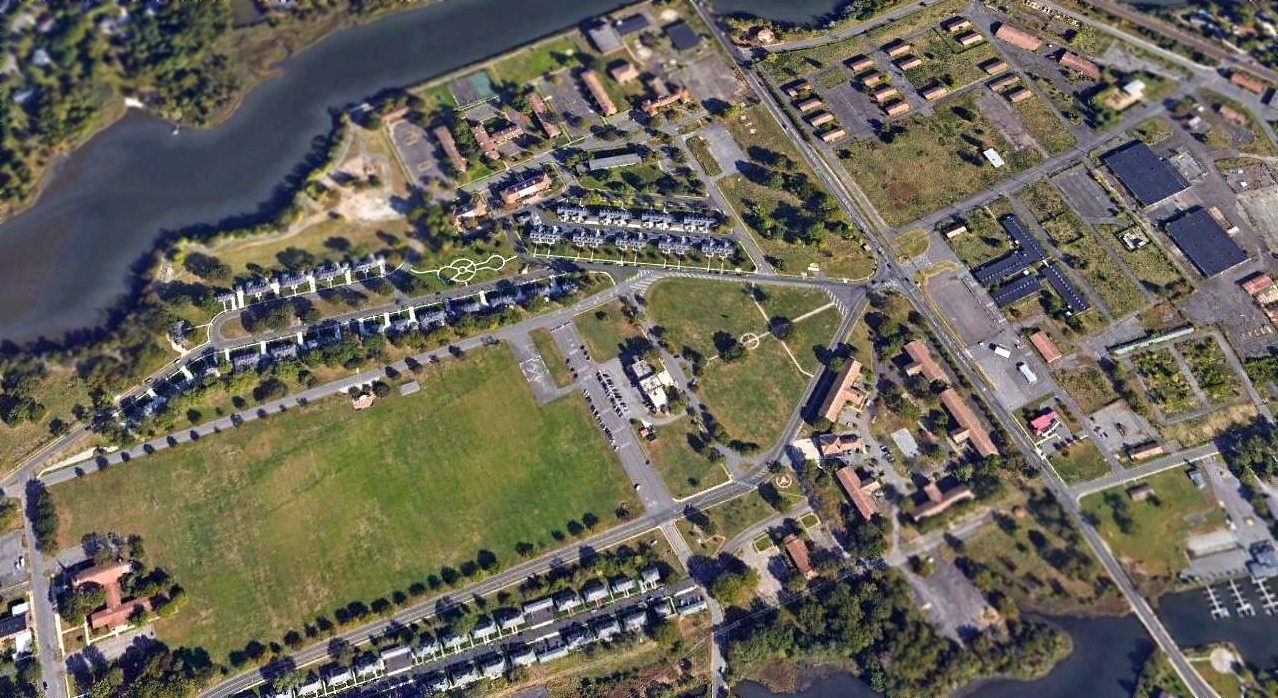
A 2019 aerial view looking north showed the Ft. Monmouth parade ground remained clear, but none of the hangars from the former airfield remained.
Thanks to Lee Corbin for pointing out this airfield.
____________________________________________________
Ocean County Airport / Huppert’s Airport / Osbornville Airport, Osbornville, NJ
40.04, -74.114 (South of New York, NY)
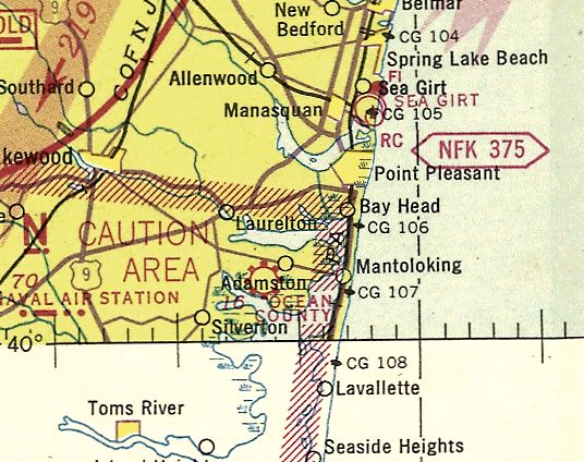
Ocean County Airport, as depicted on the November 1942 NY Sectional Chart (courtesy of Ron Plante).
Ocean County Airport was evidently established at some point in 1942,
as it was not yet depicted on a 1940 aerial photo nor on the March 1942 NY Sectional Chart.
The earliest depiction that has been located of Ocean County Airport was on the November 1942 NY Sectional Chart (courtesy of Ron Plante),
which depicted it a commercial/municipal airport.
The 1945 NY Sectional Chart depicted Ocean County as an auxiliary airfield.

Ocean County Airport, as depicted on the 1947 USGS topo map.

A circa 1940s-50s advertisement for Ocean County Airport's Huppert Aviation Company (courtesy of Gary Fitton).

The 1953 USGS topo map depicted “County Airport” as having 2 unpaved runways.

A 4/22/53 USGS aerial photo depicted Ocean County Airport as having a single northeast/southwest unpaved runway.
Two single-engine aircraft were visible near some small buildings on the northeast side.

A 1953-54 photo by Gary Fitton of a Bonanza & CAP cadet Charles White in front of the Ocean County Airport office & hangar.
Gary Fitton recalled, “Ocean County Airport... one of my teenage hangouts 1953-56, when I was a Civil Air Patrol cadet.
Our unit met here on the weekends. The runway was gravel.
We knew it as Huppert’s, but it was also known as Osbornville Airport, or Ocean County Airport.
These were mostly brand-new airplanes! Off in one of the hangars was a T-50 Bobcat.
My wife lived just off the end of the runway, and often spoke of SNJs from Lakehurst shooting landings, and even the occasional blimp.
She recalls one day when she got to sit in the gondola of one.”

A 1953-54 photo by Gary Fitton of an Ercoupe in front of the Ocean County Airport hangar.

A 2/13/54 newspaper photo of Ocean County Airport's main hangar engulfed in a mass of flames (courtesy of Gary Fitton). The fire destroyed the main hangar, 10 planes, a shed, and a panel truck.
According to Gary Fitton, “It was probably the beginning of the end for Huppert Aviation & Ocean County Airport.”

An undated photo from a 4/24/55 article showing Bruce Huppert in front of a plane & a newly-built hangar at Ocean County Airport (courtesy of Gary Fitton).
The hangar was noted to have been rebuilt after the airport's original hangar had been lost in a fire the year before.
A 1956 aerial photo depicted Ocean County Airport in the same physical configuration, but no aircraft were visible on the field.

The last aeronautical chart depiction which is available of Ocean County Airport was on the July 1958 NY Sectional Chart.
It depicted Ocean County as having a 2,750' turf & gravel runway.
An article entitled “Plan 100 homes on airport site” in the 2/13/59 Asbury Park Press (courtesy of Lee Corbin) reported,
“The Ocean County Airport will be closed & the land used for a housing development, according to Bruce Huppert, owner.”
Ocean County Airport was evidently closed by 1959, as it was no longer depicted on the April 1959 NY Sectional Chart.
A 1963 aerial photo depicted houses covering the site of Ocean County Airport.

A 9/21/10 aerial view shows the site of Ocean County Airport covered with houses.
The site of Ocean County Airport is commemorated via all of the street names of the neighborhood which replaced it:
Huppert Drive, Sky Manor Boulevard, Boeing Drive, Lockheed Road, etc.
And the park to the west of the airport site is labeled as the “Joe Pal Airport Property”.
____________________________________________________
Schlossbach Field / Asbury Park Neptune Air Terminal (ARX), Asbury Park, NJ
40.22, -74.09 (South of New York, NY)

Schlossbach Field, as depicted on the March 1940 NY Sectional Chart.
Naval aviator Issac Schlossbach purchased a 125-acre parcel of farm land in Neptune, off Route 66, in 1935
and opened an airport in 1938 under the name Ike's Jersey Aero Club - one of the first airports in central New Jersey.
Schlossbach Field was not yet depicted on the June 1939 NY Sectional Chart.
The earliest depiction which has been located of Schlossbach Field was on the March 1940 NY Sectional Chart,
which depicted Schlossbach as a commercial/municipal airport.

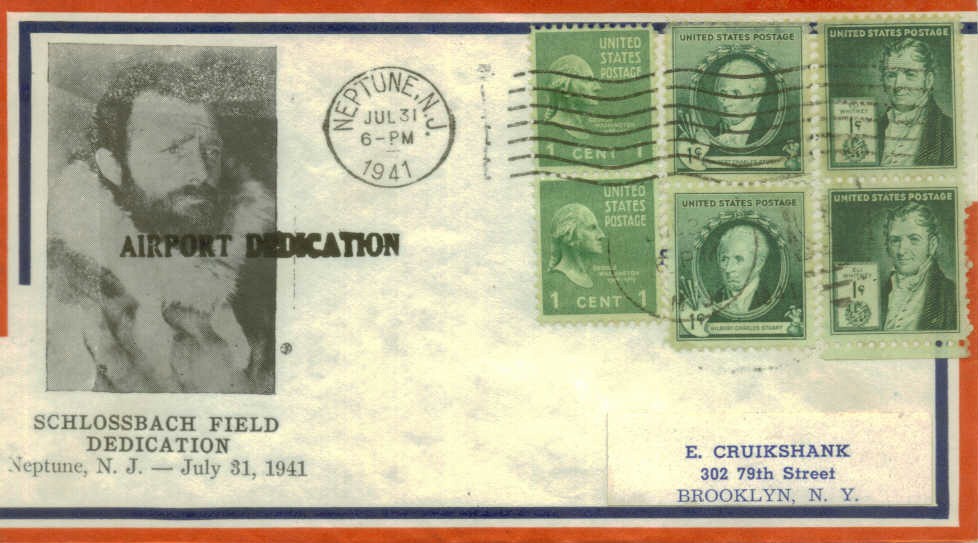
A postmark commemorated the 7/31/41 Dedication of Schlossbach Field.
Schlossbach Field trained military flying instructors during World War II, according to an article by Don Stine in The Coaster.

A circa 1940s aerial view looking south at Asbury Air Terminal (courtesy of Bruce Reid).
Schlossbach Field was not yet depicted on the 1947 USGS topo map.

A 1947 aerial view depicted Schlossbach Field as having 3 grass runways.
Several buildings were located on the north side of the field, around which were parked 7 light aircraft.

A mid-to-late-1940s aerial view by Don Reid (courtesy of Bruce Reid) looking south at Asbury Air Terminal.
A close inspection of the photo will reveal a biplane in the traffic pattern (near center of photo, just to right of the barn & above Route 66), along with another aircraft on the field.

A mid-to-late-1940s aerial view by Don Reid (courtesy of Bruce Reid) looking east at Asbury Air Terminal.
Bruce Reid observed, the photo is looking “across Route 66 from about 30' altitude.”
Several light aircraft were visible on the field, and note “Fly Here” painted on the barn.
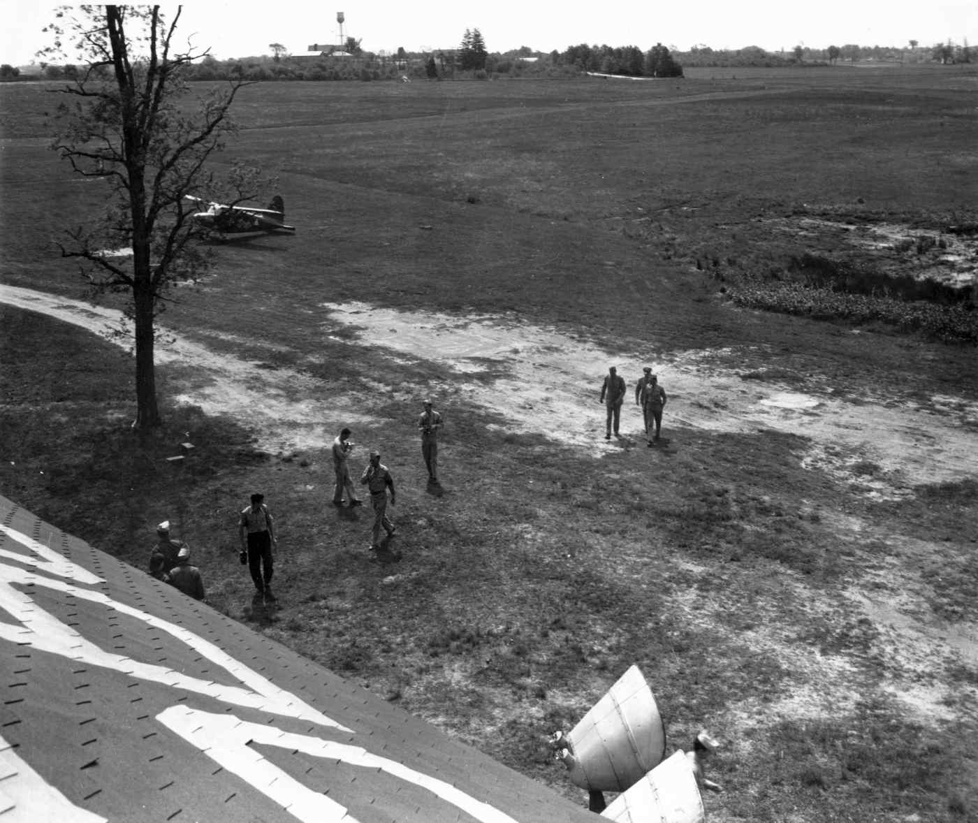
A mid-to-late-1940s photo by Don Reid (courtesy of Bruce Reid) at Asbury Air Terminal.
Bruce Reid observed, the photo is “from AAT 'Control Tower' looking toward the Jumping Brook Golf & Country Club.”

A mid-to-late-1940s photo by Don Reid (courtesy of Bruce Reid) of the Asbury Air Terminal flightline. Showing several Stearman biplanes.
George Baczkowski recalled “Asbury Park Air Terminal brought back great & happy memories of a rustic, old fashioned & friendly little field,
full of character & characters – not the least being Ike Sclossbach.
The Airfield, although known as Schlossbach Field was in the 1940s & 1950s called Jumping Brook (Air)Field.
The Jumping Brook being a spring that traversed the field & fed – underground – the pond, which never ran dry.”
The field had been renamed Asbury Park Air Terminal by the time of the 1950 NY Sectional Chart (courtesy of Mike Keefe).
It was described as having a 2 unpaved runways, with the longest 2,350'.
Bruce Reid recalled, “Ike had 2 horses that could, at times, free-range on the airport grounds.
That is why that pond was dug (for the horses to drink from).
My sister Dorothy & I would ride, exercise & groom the horses on weekends in the early 1950s. Their names were King & Cactus.”
According to an article in the 10/4/51 issue of the Philadelphia Evening Standard (courtesy of John Bircher),
"Issac Schlossbach of the Asbury Park Air Terminal paid $1,560 for 6 individual airplane hangars",
at an auction of the assets of Philadelphia's Boulevard Airport, following its closure.
A 1957 aerial view depicted a new somewhat longer east/west runway which has been added at some point between 1947-57.

An undated photo of a taildragger being hand-propped in front of the Asbury Park Air Terminal office.

The 1959 Jeppesen Airway Manual (courtesy of Chris Kennedy) depicted the Asbury Park Air Terminal as having 3 unpaved runways,
with the longest being the 2,600' Runway 9/27.
A long T-hangar was depicted on the northeast side of the field, along with a number of smaller buildings.
George Baczkowski recalled “As the airfield expanded in the late 1950s it took the title Asbury Park Air Terminal.
The terminal, as Ike told me, was in fact the first 2-floor chicken house in the USA, converted to ‘civil’ use!
On a hot summer’s day, its past history could be sensed.”

A 1960 photo by John Hansen of Bruce Reid & John's 1946 Aeronca (“that we rebuilt from a basket case”) at the Asbury Park Air Terminal (courtesy of Bruce Reid),
before their flight to Bader Field, to “walk to the boardwalk for ice cream & sightsee.”

The 1961 NY Local Aeronautical Chart (courtesy of Tim Zukas) depicted Asbury Park - Neptune Airport as having a 3,000' unpaved runway.

A 1960s photo by Emmett Francois of Asbury Park Air Terminal founder Ike Schlossbach.
According to Emmett Francois, Schlossbach had “the rank of Lieutenant Commander in the US Navy.
I also was told that Ike was the first Jewish midshipman at the U.S. Naval Academy.
One of the things that affected his looks was the fact that he had a glass eye. Even so he could taxi an aircraft around like it was car.”
Undoubtedly the most unusual vehicle operated from Asbury Park Air Terminal was the Reid “Flying Submarine” RFS-1.
Bruce Reid recalled, “My dad was manufacturing patented radio controlled model submarines as a business
when a set of model airplane wings accidentally fell from a shelf across the hull of one of them in his basement workshop.
Dad looked at it for a moment & asked 'Why not, - why not a flying submarine?'
That was the birth of an idea that 'consumed' the rest of his life.
Why, and for what purpose (as did ask Henry Morgan of my father on stage of the national TV program 'I've Got a Secret').
If you may remember the Cold War, a flying submarine in the hands of an enemy power could have approached our shores without ever being detected by radar!”
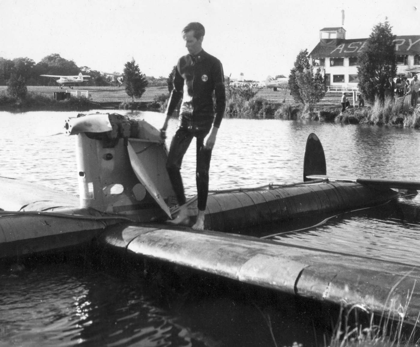
A 1961 photo of Bruce Reid entering the Reid RFS-1 Flying Submarine in the Asbury Park Air Terminal pond (courtesy of Bruce Reid).
Bruce Reid recalled, “I was the pilot of the Flying Sub! Flying Sub tests at the airport began during the summer of 1961.”
George Baczkowski recalled, “A converted Forney Aircoupe, it was tested in the pond.”

A 1961 photo of the Reid RFS-1 Flying Submarine in the Asbury Park Air Terminal pond (courtesy of Bruce Reid).

A 1961 photo of the Reid RFS-1 Flying Submarine in the Asbury Park Air Terminal pond (courtesy of Bruce Reid).
Bruce Reid recalled, “FS suffered an air supply line failure which was repaired within moments & resurfaced under complete control.”

A circa 1960s aerial view by Dick Lewis looking north at Asbury Park Air Terminal.
Dick observed, “Note that the East-West runway is unpaved (mostly) and other areas appear undeveloped.
I instructed there during that time period & also was part of the 'Jersey Aero Club' & the 'Asbury Air Terminal Sky Divers' club.
Bruce Reid recalled, “I started flying at Asbury Air Terminal on 6/3/62 in my friend's Aeronca Chief with highly known & respected CFI Lou DeFasio.”
The 1962 AOPA Airport Directory described Asbury Park Neptune Air Terminal as having a 3,000' gravel runway (9/27) & a 2,500' grass runway,
and the operators were listed as Isaac Schlossbach & Edward Hall.
A 1963 aerial view depicted Asbury Park as having 3 unpaved runways.
Richard Kenyon recalled, “Asbury Park (Neptune) Airport... Dick Bach had a Fairchild restored by Ike Schlossbach at that airport many years ago,
and the account of it was written up in Flying Magazine, probably in the early to mid 1960s.
There was also a P-51 & F-8 based there, and it was an audible & visual treat when these great birds landed or took off.”

A 1960s photo of a beautiful surplus Ryan PT-22 Recruit trainer at Asbury Park Air Terminal (courtesy of Emmett Francois).

A 1965 photo by Emmett Francolis of the Asbury Park Air Terminal office, with a Twin Beech in front.
Emmett Francolis recalled, “In 1964-1965 I was leaning to fly at Asbury Park Airport.
At the time I was working for The Reader's Digest in New York but I lived in Teaneck, NJ.
Our life-long friends moved to Neptune & while we were there I visited the airport
and found a Model A Ford coupe in need of restoration.
After approaching Ike Schlossbach I offered to help with the restoration if he would teach me to fly.
He had 2 instructors who were brothers that did the flight instruction: Donald & William Leefe.
The planes they used to teach with were Aeronca 70C & 7AC's.
Commuting between Teaneck & Asbury Park did not leave a lot of time to do the restoration work & also get in some flying time.
We did get the old Model A up & running and even got to give it a coat of primer before I had end my flying lessons.
I do remember the banner fliers keeping a frequent schedule while I was working there.
One flier owned a Bearcat.
The propeller on that single engine plane was huge
and he remarked how he could not afford to fly it much since it consumed so much fuel.”

A photo by Emmett Francois “of a Stearman that was at the Asbury Park Air Terminal while I was flying out of there in the 1960s.”
The 1965 NY Sectional Chart (courtesy of John Voss) described Asbury Park Neptune as having 3 turf runways, with the longest being 3,000',
but the remarks included "NW/SE runway closed".
Chuck Maire recalled, “My first flight instructor job was with Billy Gibson at Asbury.
I met Ike there who lived at the airport in a small house with one light bulb & no water to speak of.
The flight school was not much better in that regard. To say it was a colorful airport was an understatement.
I towed banners for a couple of seasons while in college there.
I could tell stories that you would find hard to believe about that place.”
George Baczkowski recalled, “An article on Asbury by James Gilbert was published in Flying Magazine 1966/67 under the title ‘The One Horse Airport’
with the opening ‘Beneath its untidy ramshackle exterior there beats a heart of gold.’ Yes – 100%!”
"Ike" Schlossbach owned & operated the airport until approximately 1966-67,
when he leased the operation to Dick Davis, a local auto dealer & avid pilot.
In Rich's words, "The runway was paved sometime between September 1965 & January 1966.
I had taken lessons & soloed there on the 'grass' (gravel) runway in August 1965, and at the end of the month I went off to college.
When I came back to NJ for the semester break over the Christmas holidays the runway had been paved."
According to pilot Ed Drury, during rainy periods,
the pond adjacent to the north side of the runway would overflow & flood the runway.
Skydiving operations were conducted at Asbury Park.
George Baczkowski recalled “In 1968-71 I was a flight instructor with Bill Gibson in his Gibson’s Air Academy -
having landed the job in exchange for stripping his P-51 - N5412V of its old white paint.
Also at the field in the late 1960s was an air taxi operation - Piper Twinnair - operating PA-30s, PA-23s, and 2 of the prototype PA-31 Navajos.
The name came from one of the directors (Tom Hartford?) who married Piper’s daughter.”
According to Ray Lewis, his cousin Carl Lewis worked at Asbury Park in the late 1960's & early 1970's
attaching banners to be trailed by small aircraft up & down the beaches.
The banner towing operations were later moved to Allaire Airport after Asbury Park closed.
"Asbury Park Neptune" Airport was depicted on the 1969 USGS topo map.
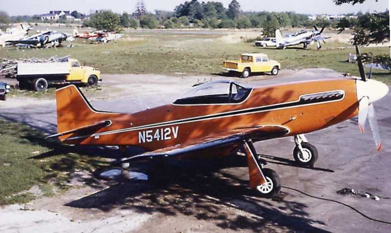
A 1969 photo by George Baczkowski of a beautiful P-51D Mustang at Asbury Park Neptune Air Terminal,
with a Grumman F8F Bearcat & other aircraft in the background.

A beautiful 1969 aerial view of George Baczkowski flying Bill Gibson’s Ryan PT-22 over Asbury Park Air Terminal (courtesy of George Baczkowski).

A May 1969 photo by Chester Christopher of a F8F-2 Bearcat taking off from Asbury Park Neptune Air Terminal,
with the landing gear caught in mid-retraction.

A 1970 aerial view depicted Asbury Park as having a single paved runway, and an unpaved north/south runway.
It appeared as if the 3rd (northeast/southwest) runway had been abandoned. A total of over 45 aircraft were visible on the field.

The 1972 Flight Guide (courtesy of Chris Kennedy) depicted Asbury Park as having a 3,000' paved Runway 9/27 & a 2,300' unpaved Runway 2/20.
A total of 9 buildings (hangars?) were depicted on the northeast corner of the field. The field was noted to have glider activity.

An early 1970s photo of Chuck Maire doing a banner pickup (at an amazingly high pitch angle!) in a Citabria at Asbury Park Air Terminal.

A circa 1972-73 photo of N5216X, a 1969 Champion 7GCAA Citabria, serial #201, at Asbury Park Air Terminal.

An undated aerial view looking southwest from the 1973 NJ Airport Directory depicted Asbury Park as having a single paved Runway 9/27 & an unpaved north/south runway.
The airport was very popular, with dozens of light aircraft parked on the field.

The last photo which has been located depicting Asbury Park Air Terminal while still open was a circa 1973 photo of Chuck Maire's roommate's Cessna 140 & other aircraft.
Chuck Marie recalled, “Billy Gibson ran the flight school at the Asbury Airport.
He gave me my first job as a flight instructor at the Asbury Airport in 1973.
Ike Schloshbach owned & lived at the field when I instructed there.”

Asbury Park Neptune was still depicted as an active airport on the 1975 NY Terminal Area Chart (courtesy of Mike Keefe), although the field's name was misspelled, as "Ashbury Park".
It was depicted as having a 3,000' paved runway.

A circa 1977 aerial view looking northeast at Asbury Park Air Terminal (courtesy of Richard Lewis).
Richard Lewis observed, it was “likely taken around the airport's closure (1977) since there is little evidence of operation”, with only 2 aircraft evident on the field.
Asbury Park Neptune Airport closed in 1977.
Emmett Francolis remarked, “The story about the airport closing is a familiar one.
General aviation has shut out many who wished to learn how to fly because of taxes
and people who build around an airport & then complain about the noise.”
In a 1996 report by the New Jersey General Aviation Study Commission's Subcommittee on Airport Closings,
reasons were given for the closing of 13 New Jersey general aviation airports.
According to the report, taxes at Asbury Park Air Terminal rose more than 600% from 1966-1972, climbing from less than $6,000 to $36,000.

The last photo which has been located showing an aircraft at Asbury Park Air Terminal was a 1977 photo by Chuck Maire
of “a Cessna landing right after the closure. No 'X' on the runway yet.”
On the 1986 USGS topo map, the runway was still depicted, but unlabeled.
On the 1989 USGS topo map, nothing at all was depicted at the Asbury Park Air Terminal site.
The airfield was not depicted at all (even as an abandoned airfield) on recent aeronautical charts.
Since Asbury Park Air Terminal's closure, 2 commercial buildings have been constructed along the northern portion of the airport property, fronting Route 66.

A 3/28/95 USGS aerial photo showed that most of Asbury Park's Runways 9/27 & 2/20 still existed.
Closed runway "X" markings were still visible along the middle portion of the Runway 9/27.

A 1997 aerial view looking south at the remains of Asbury Park Air Terminal by Philip Kineyko.
A later aerial photo from 2001 confirmed that the runway still existed in the same state.
Tom Rutherford reported in 2005, “It looks like they are going to build an upscale mall on that site some time in the next year or two.
The shopping malls are popping up all over that area.
So far they have build a huge WalMart & Home Depot in the area & there are talks of this new mall.
The runway is still there.”
William Angus reported in 2005, “Asbury Park airfield is still there,
though locals with ATV have carved numerous trails into the woods & the property is up for sale.
There are 3 construction vehicles on site & certain sections (very small sections) appear to have been leveled like a lawnmower.
Also something very strange was that some trees were being dug up & their roots wrapped,
as if they were going to be sold or transplanted elsewhere.”

A circa 2006 aerial view looking east showing a section of the Runway 9/27 pavement which remains intact at Asbury Park.
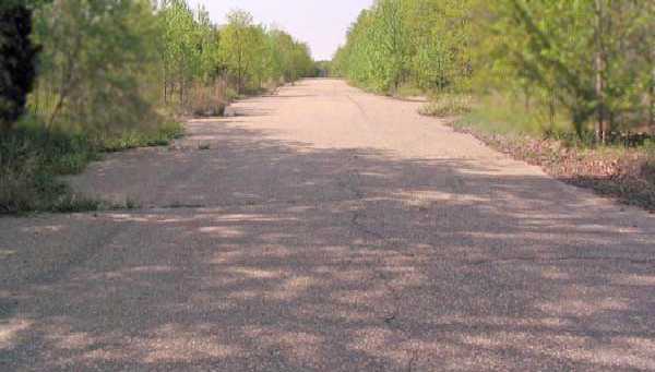
A circa 2009 photo looking along the remains of the Asbury Park Runway 9/27 pavement.

A 9/26/13 aerial photo showed that Hovchild Boulevard had been built over the alignment of Asbury Park's Runway 2/20.
Matt Treharne reported of the Asbury Park Air Terminal site in 2014, “Someone has clearly bought the land & is clearing it of all trees to construct something.”
Bruce Reid reported in 2015, “The Flying Sub [tested in 1961 at Asbury Park] is now at the Mid Atlantic Air Museum in Reading, PA.”

A 1/14/21 photo by Chuck Maire of “of my sister standing on what is remaining of the Asbury Park Air Terminal, looking east from where would have been about 1/4 of the way down Runway 9.
A Hampton Inn now sits where the beginning of the runway once was.”
The site of the Asbury Park Air Terminal is located southeast of the intersection of the Garden State Parkway & Route 66.
____________________________________________________
Colts Neck Airport (N61), Colts Neck, NJ
40.278, -74.182 (South of New York, NY)
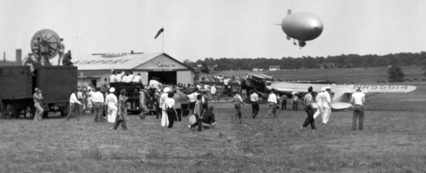
A circa 1946-49 photo by Don Reid of an airshow at Colts Neck Airport (courtesy of Bruce Reid),
with a Navy blimp coming in over the hangars, aircraft, and a truck-mounted radar.
Colts Neck Airport was not yet depicted on the 1934 NY Sectional Chart.
According to "Colts Neck: A brief history" (from the 10/18/01 issue of the Asbury Park Press),
the Colts Neck Airport was built in 1938.
However, no airport at Colts Neck was depicted on the November 1942 NY Sectional Chart (courtesy of Ron Plante) or 1945 NY Sectional Chart.
The earliest depiction which has been located of Colts Neck Airport was a circa 1946-49 photo by Don Reid of an airshow at the little airport (courtesy of Bruce Reid),
showing a Navy blimp coming in over the hangars, aircraft, and a truck-mounted radar.

A 1947 aerial view depicted Colts Neck as having 2 grass runways, with 3 hangars just north of the runway intersection.
No aircraft were discernible on the field.
Colts Neck Airport was still not depicted on the July 1947 NY Sectional Chart.

The earliest aeronautical chart depiction of Colts Neck Airport which has been located was on the January 1948 NY Sectional Chart.
It depicted Colts Neck as having a 2,400' unpaved runway.
Pat Faley recalled of Colts Neck Airport, "The Airport was located west of NJ State Highway 34,
just south of Monmouth County Route 537
and just north of NJ State Highway 18 (which was still under construction when the airport closed).
The only entrance to the airport was off of Route 537
and required a drive down a dirt road & a stop sign to cross a runway to get to the hangar/office area.
There were 2 grass runways in a standard cross formation, both around 3,000'.
While I can't remember the owner's name, I do remember that he had his 1st pilot license hanging in the office.
It was signed by Orville Wright."
J.H. Cubbage recalled, “When I was very young (1952?), I visited my Uncle Bill at the Colt's Neck airfield.
He was a pilot & I think he was serving as a manager.
I remember there was a cold soda chest in front of the office & I drank a strawberry soda.
Soda bottle caps were on the ground.
I remember someone talking about a flying license signed by a Wright brother hanging on the wall of the office.”
The Colts Neck was not yet depicted at all on the 1954 USGS topo map.
A 1957 aerial view depicted Colts Neck in the same manner as the 1947 aerial view.
A single light aircraft was visible on the northwest/southeast runway.
The 1961 NY Local Aeronautical Chart (courtesy of Tim Zukas) depicted Colts Neck Airport as having a 2,400' unpaved runway.
A significant increase in usage was apparent on a 1963 aerial view,
in which a total of 12 light aircraft were visible parked along the north side of Colts Neck Airport.
Chuck Maire recalled, “I was a line boy at Colts Neck Airport.”

The 1968 Flight Guide (courtesy of Robert Levittan) depicted Colts Neck Airport as having 2 unpaved runways: 2,400' Runway 6/24 & 1,350' Runway 14/32,
with 3 small buildings northeast of the runway intersection.
Mark Childers recalled, “I took ground school & my first couple of private pilot license flight training at Colts Neck Airport in 1966-68.
I remember flying over to another tiny strip in Colts Neck – the runway was no more than 2,000' - for touch & go's.
My 1st flight was 15 minutes in an ill-tempered 1950 Super Cub that had a steady misfire.”
Andrew Smith recalled, “In tha late 1960s up to about 1974, Colts Neck Airport was the destination of some quick flights from Hanover NJ, where Dad kept our PA-12.
I recall the formidable compound of storage bunkers at a Naval weapons depot that helped us find our way to Colts Neck in NJ's thick summer haze.
Back then, Colts Neck was home to a fleet of hardworking adulterated Cub banner-towing planes. They all looked pretty rough.
Shortly after I got my commercial ticket, I had the idea of using our PA-12 for banner work as a time-builder.
The banner company boss at Colts Neck encouraged me to come work as a contract plane & pilot, but 2 factors nixed it:
1) After several conversations with the head guy at the banner company's office, too many details remained vague.
2) Adding Part 91 commercial use to our PA-12 policy was met by our long-time insurer’s unequivocal 'Not possible - Don’t even think about it.'”
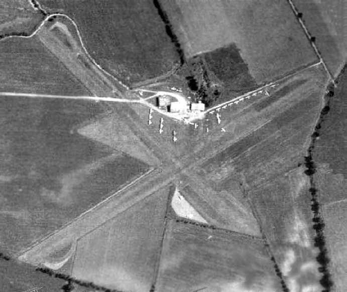
A 1970 aerial view depicted Colts Neck Airport perhaps at its zenith of popularity,
with a total of 26 aircraft visible parked on the northeast side of the field.
Kevin Smith recalled, “I flew for the first time out of Colt's Neck, and Paul Willy was the instructor.
'Ramshackle' was one way to describe the place.”
Larry Baggitt recalled, “In the 1970s I would ride my bike to the Colts Neck Airport where I would have a soda & hang out.
I was allowed to sit in them [the airplanes] & it was a wonderful time.”
Ed Drury recalled, “Circa 1976 my brother lived in the area and on Friday's the Garden State Parkway was so crowded that he commuted from Linden Airport to Colts Neck Airport.
We had a Cessna 172 with a 220 hp conversion. It would operate out of 280 feet.
He learned to fly there & the instructor taught him to 'Flare at the top of the corn.' He was doing well until they cut the corn & he botched the next landing.
I often would take him home if I needed the plane for the weekend. I remember steering around the 'bomb craters' as we called them.
The takeoff had to be planned around these same 'craters'.
It was a warm friendly old time airport, and a short walk to the great Colts Neck Inn. I was very sad when they closed it.”
Keith Botts recalled, “Colt's Neck... I was stationed at Ft Monmouth in 1978-79 & did some of my earliest flying there.
The airport manager (I believe he was also the owner) was Paul Wirth.
He had a beater Cessna 150 that you had to start by pulling a handle out of the panel.
That closed the contractor on the starter. It had radios, sort of.”
Keith continued, “Flying was a trip. The runway was always rough, sometimes muddy.
Takeoff started at the (usually) east end of the main east/west runway with 10 degrees flaps,
you pulled the yoke half back, firewalled the throttle with the brakes locked, and let it go when it stabilized.
Bounce down the runway, front wheel about 6 inches off in 20 feet,
drive down the runway that way until the airspeed needle looked like it was going to move slightly, and it lifted off in ground effect.
Nose slightly down, gain airspeed in ground effect and then to Vx to clear the junk at the end.
Flaps in, turn to pattern, go around & land the same direction with full flaps, just above stall with the nose up & some throttle.
If you didn't do it that way, it would sink your floating kidney during the ground roll & Paul would chew your butt for beating up his airplane.”
Keith continued, “I did my first solo cross country Colts Neck – Millville - Atlantic City - Colts Neck.
The guy who came out to sign my logbook said 'You're from Colts Neck, aren't you?'
The airplane was covered with mud from the strut attach to the stabs. You couldn't even read the tail number.”
Keith continued, “Takeoff from the north/south runway went over Naval Ammunition Depot, Earle on the South end if you went too far.
That was a Restricted zone, although they didn't get too excited about it.
They had Paul's phone number, though (a black phone extension off the pay phone on the front of the FBO).”

An undated aerial view looking northwest from the 1979 NJ Airport Directory depicted Colts Neck Airport as having 2 turf runways:
2,490' Runway 6/24 & 2,060' Runway 14/32, with a cluster of small buildings north of the runway intersection.
The manager was listed as Paul Wille, and the Fixed Base Operators as Sky Advertising & Wilco Aviation.

The 1979 NY Terminal Area Chart depicted Colts Neck as having a 2,500' unpaved runway.

The 1981 topo map depicted Colts Neck Airport as having 2 unpaved runways,
with a cluster of small buildings north of the runway intersection.
Mike Pilla recalled, "I towed gliders from a roughly 2,400' grass strip in Colts Neck.
We used a Cessna 150 with a 150 hp engine & had to consult a density altitude chart
plus minimum wind and/or maximum x-wind component chart before towing activities on any day could commence.
During most of the summer, towing was limited to single place ships,
sometimes 2 place ships flown solo, rarely dual.
Training a new tow pilot, in the hot & humid summer was impossible.
If the density altitude exceeded about 3,500', there was no towing at all."
Craig "Red" Heun recalled, “Colts Neck Airport... I got my private there on 6/3/83 with Tom Ford as my instructor.
The FBO was run by Paul Willy.
There was banner towing (using mostly Bird Dogs), glider flying, and sometimes in the evening & morning hot air balloons.
It was a great place to learn & had the 'old time' airport feel. Absolutely nothing fancy about it.
As I recall the roof in the office leaked, had a wood stove for heat & nothing that could be considered running water.
I have been all over this country & seen many airports, but I fondly remember Colts Neck as a real airport.
It was in the middle of a corn field, taught you the hard facts about the use, or misuse, of ground effect
as well as how to divide you attention between flying final & the surrounding environment which often included deer & geese.
I got my first biannual with Ed Burke at Colts Neck so many years ago.”
Rich Peabody recalled, "When I moved here in 1984 I stumbled upon an airport in Colts Neck…
a grass field with about 30 based aircraft, and an additional 10 soaring ships.
There was a row of T-hangars & a conventional hanger that housed a Stearman in incredibly rough condition
that I bartered a ride in from the kid that seemed to be the FBO / instructor / glider tug guy."

The last aeronautical chart depiction which has been located of Colts Neck Airport
was on the June 1985 NY Sectional Chart (courtesy of Mitchell Hymowitz).
It depicted Colts Neck as having a 2,500' unpaved runway.
Pat Faley recalled, "As Colts Neck became a very exclusive & pricey town to live in
(million-dollar estates, horse farms, and 5 acre zoning), there was no place for the airport. Very Sad."
Bill Bienes was employed at an aircraft repair shop at Colts Neck Airport up until the point of its closing.
"I left that place with tears in my eyes the day it closed", he said.

An undated photo of a Piper Cub inside a Colts Neck hangar.

A circa 1987-88 aerial view by Ed Burke looking north at Colts Neck Airport.

A circa 1987-88 photo by Ed Burke of a few Cessnas in front of the hangars at Colts Neck Airport.

A circa 1987-88 photo by Ed Burke of a hangar at Colts Neck Airport.

A circa 1987-88 photo by Ed Burke of a hangar at Colts Neck Airport.
Adam Rosenberg recalled, "I got my Private Pilot License in 1987 May
and continued to rent airplanes until 1988 August when Colts Neck Airport was finally shutting down
after decades of pressure from real estate developers.
Colts Neck Airport has been turned into a housing development of all-the-same McMansions on tiny plots of land."
Adam continued, "The joys of a small airport are hard to describe to somebody who has not spent time at one.
Colts Neck Airport, once known in the registry of the Federal Aviation Administration as N61,
was about small, simple airplanes & people flying them.
I believe I was the last person who learned to fly there.
My solo date was 12/7/86."
Adam continued, "N61 was in Colts Neck, an upscale community in Monmouth County,
close enough to the beach to be considered part of the Jersey Shore.
The forces of housing development finally won the war
against the desires of a few old, moldy pilots & it closed a few years ago.
But N61 lives on in our hearts."
Adam continued, "N61 was 2 runways & a seriously-beat-up hangar & office.
The hangar door had enough gaps to let the pigeons inside,
so covering the wings with a tarp was a part of N61 indoor parking.
Most airplane owners took their chances outside with the occasional snow.
The runways were rutted with enough gaps in the grass that its Yahoo group calls itself MuddyRunways.
The usual runway, 25, was 2,500' long with bushes & cornfields at the ends.
An expertly done short-field landing there was rewarding with a little flick sound of cornstalks brushing against the wheels.
Every runway roll, take-off or landing, had a bumpity-bump-bump feel
as the airplane rolled & hopped over the ruts in the runway."
Adam continued, "The FAA database said we had a Unicom radio frequency (122.8),
but nobody on the field ever listened to it,
and they said we had fuel, but no pilot I know trusted it to have more gasoline than water.
Colts Neck Airport was not about luxury in flying."
Adam continued, "The L-19 pilots used to cut toilet paper in the air.
The idea was simple: One would nick a roll from the bathroom (and the owner always wondered where it went so quickly),
throw it out the window of the airplane,
and try to cut the stream as many times as you could before the toilet paper (or the airplane) hit the trees."
Adam continued, "My favorite part of Colts Neck Airport life was Octoberfest.
We would all get together the 1st nice weekend in November,
always early November because pumpkins (which we called 'punkins' in New Jersey) were cheap right after Halloween.
We would load up our L-19 Bird-Dogs & Cessna 150s & Luscombes & Cubs & try to hit a pre-designated spot in a field."
Adam continued, "Colts Neck Airport may be gone, but the skies will never be totally sane & stodgy so long as we're still up there."
In a 1996 report by the New Jersey General Aviation Study Commission's Subcommittee on Airport Closings,
reasons were given for the closing of 13 New Jersey general aviation airports.
According to the report, "At Colts Neck Airport, the corporation which bought the land for development
and then decided not to proceed because of a downturn in the economy
closed the airport on the advice of lawyers who recommended the action because of alleged exposure to liability."
The December 1993 NY Sectional Chart (courtesy of Ron Plante) no longer depicted Colts Neck Airport.

A 1995 USGS aerial photo showed the site of Colts Neck Airport was still open & not yet redeveloped,
but the outline of either runway was no longer recognizable.
It appeared as if the hangars still remained intact, though.
According to the 1996 report by the NJ General Aviation Study Commission's Subcommittee on Airport Closings,
"That land is still vacant."
That status of the property apparently didn't last too long,
as William Angus reported in 2005, “Colts Neck airfield is completely gone... it is nothing but McMansions.”

A sad 9/6/13 aerial photo showing a golf course community covering the site of Colts Neck Airport.
Craig "Red" Heun recalled, “Maybe it's fantasized nostalgia, but I look at one of those painting/prints sold through Sporty's or The Wright Brothers catalogs
of the J3 sitting in front of an old hangar on a farm, it reminds me of that once magic place, in the once 'Garden State' known as Cots Neck Airport.
It's a shame the developers won the war in the destruction of Colts Neck. I guess condos of the pseudo-rich take priority.”

A 2/14/25 photo by Alexander Szeremeta of the community which covers the site of Colts Neck Airport.
Andrew reported, “I’m a 16-year-old student pilot. I discovered I live on almost the exact spot that the Colts Neck Airport FBO used to be.”
The Colts Neck Airport site is located south of the intersection of Route 537 & Route 34.
____________________________________________________
Red Bank Airport, Red Bank, NJ
40.327, -74.08 (South of New York, NY)

Red Bank Airport, as depicted on the 1930 "Rand McNally Standard Map of NJ With Air Trails" (courtesy of Chris Kennedy).
According to the book "Tinton Falls" (via Douglas Wright),
Red Bank Airport was built in 1926 by Air View, Inc., on part of the George Hance Patterson farm.
Jack Casey was the pilot for the company, which performed aerial photography.
The 1930 "Rand McNally Standard Map of New Jersey With Air Trails" (courtesy of Chris Kennedy)
described the Red Bank Airport as being operated by the Air View Flying Service.
The field was described as consisting of a rectangular field, measuring 2,700' east/west x 2,500' north/south.

The earliest aeronautical chart depiction which has been located of Red Bank Airport
was on the November 1931 NYC-Albany Air Navigation Map.

A circa early-1930s aerial view of Red Bank Airport
depicted the field as a roughly square grass field, in the center of which was visible 2 airport circle markers.
The 1934 Department of Commerce Airport Directory (according to Chris Kennedy)
described Red Bank Airport as consisting of a 2,700' x 2,200' sod rectangular landing area.

A circa 1930s brochure for Red Bank Airport's Airview Flying Service (courtesy of Tom Heitzman).

A circa 1930s photo of a Fairchild FC-2 monoplane of Airview Flying Service being loaded in front of Red Bank Airport's hangar & beacon tower (courtesy of Tom Heitzman).

A circa 1930s photo of a Waco YOC biplane in front of Red Bank Airport's hangar & beacon tower.

An aerial view looking northeast at Red Bank Airport,
from the Airport Directory Company's 1937 Airports Directory (courtesy of Bob Rambo).
The directory described Red Bank Airport as consisting of a 185 acre rectangular sod landing area.
The aerial photo in the directory depicted a single hangar at the corner of the field.
Richard Marlin recalled, “Red Bank Airport... Walter Laudenslager came to the airport in 1938 & ran a charter & flight school.”
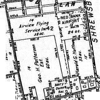
A 1941 street map (courtesy of Douglas Wright) shows how tightly the airport property was situated,
as a total of only 77 acres contained 2 runways, oriented east/west & north/south.
Richard Marlin recalled, “When the 2nd world war started, [Walter Laudenslager] signed with Monmouth Junior College in West Long Branch
to start a civilian pilot training program with the U.S. Government.
When the government took over the airport they painted over the name on the hangar & moved the CPT program to Red Bank Airport.”

1/1/46 photo by Calvin Burdge of his Waco in front of a Red Bank Airport hangar (courtesy of Charles Burdge).

A series of 1946 photos of Red Bank Airport by Donald Orndorf, showing an Ercoupe, several biplanes, and a Luscombe 8A.
S

An undated photo of Stinson SR-9D NC17114 in front of the Red Bank Airport hangar (from the Job Conger IV collection, courtesy of Mark Nankivil).

A circa 1946/47 brochure for Red Bank Airport (courtesy of Tom Heitzman).
Red Bank Airport had some early military use,
as the Army's Communications-Electronics Command (CECOM) Flight Activity
was located at Red Bank Airport after WW2, before being moved to Allaire airport.
The 1947 USGS topo map depicted an aeronautical beacon at the site of Red Bank Airport,
but did not depict the airport itself.
A 1947 aerial view depicted a dozen light aircraft parked around a single hangar on the northeast side of Red Bank Airport.

Red Bank Airport, as depicted on the 1950 NY Sectional Chart (courtesy of Mike Keefe).
A small charter & commuter airline firm, Air Taxi, began operations from Red Bank in 1950.
Air Taxi was run by Jim Loeb.
They offered commuter flights to Newark & JFK.
Richard Marlin recalled, “Red Bank Airport... I started flying there in 1951 & got my private license on a J-3 Cub.
At that time it was owned by Walter Laudenslager.”

The 1953 USGS topo map depicted Red Bank as having 2 unpaved runways
with several buildings & a beacon on the northeast side of the field.

A November 1956 photo by Barbara Anderson Rosa (courtesy of Douglas Rosa) of a Piper TriPacer in front of the Red Bank Airport hangar.
Douglas Rosa recalled, “My mom used to date a guy [who] took a her & a friend for plane rides out of Red Bank Airport.”

A November 1956 photo by Barbara Anderson Rosa (courtesy of Douglas Rosa) of 2 Beech Bonanzas & a Piper TriPacer at Red Bank Airport.

The 1960 Jeppesen Airway Manual (courtesy of Chris Kennedy)
depicted Red Bank as having 2 unpaved runways (2,600' Runway 8/26 & 2,400' Runway 17/35),
with 2 buildings on a ramp on the northeast side of the field.
Bill Salisbury recalled, “I worked for Jim Loeb at Air Taxi Company in 1960 & early 1961 as a pilot.
I flew Beech Bonanzas, a Debonair, and Piper Apaches & an Aztec.
We put in some very long hours & often pressed the weather more than we should have.
I have a lot of fond & some no-so-fond memories of working there.
There used to be a restaurant & bar right next door to the airport, facing Shrewsbury Avenue, I believe it was called the Airport Inn.
They had some of the best hamburgers one could imagine.
We often ate there when time permitted.
I was a young guy of 23 years old & lived in an apartment on Bridge Avenue with my new, young wife.
Often times, coming home from one of the 3 major airports in New York where we flew shuttle charters back & forth all day,
I would alert my wife that I would be coming home for dinner soon,
by flying low over the apartment & putting the prop into low pitch as I passed over.
Then, I would pull up & land at the airport, put the airplane to bed for the evening, do my paperwork & head home.”
Dick Lewis recalled, “The Airport Inn was on the corner of Apple Street & Shrewsbury Avenue very close to the terminal.”
The 1961 NY Local Aeronautical Chart (courtesy of Tim Zukas) depicted Red Bank Airport as having a 2,600' unpaved runway.

An undated photo from a September 1962 article depicted a Beech Bonanza in front of Red Bank Airport's distinctively-styled terminal building.
Red Bank was listed among active airfields in the 1962 AOPA Airport Directory,
with 2 turf & gavel runways (the largest being 2,700' long),
and the operator listed as Red Bank Airport Inc.
A 1963 aerial view depicted a dozen light aircraft parked on the northeast side of Red Bank Airport.
It also showed that 2 additional hangars had been added at some point between 1957-63.

A 1963 photo of an unidentified group in front of a Piper Apache & Red Bank Airport's distinctively-styled terminal building (courtesy of Gary Fitton).

A 1964 photo of Santa Claus being flown by Guy Aliotta in a Bell 47 helicopter at Red Bank Airport (courtesy of Tom Aliotta).
Tom Aliotta recalled, “Red Bank Airport... my father was a flight instructor there in 1964; he worked for Astro-Flight, Inc. based at the airfield.”

A circa 1960s photo of Guy Aliotta in front of an air taxi Beech Bonanza at Red Bank Airport (courtesy of Tom Aliotta).
Tom Aliotta recalled, “He was Vice President & Chief Instructor at Aero Knights Inc.”
Jeff Owens recalled, “I took my first flying lesson at Red Bank in 1964.
I remember as a small boy going there when the end of the runway was a board fence made of 2 x 10
with only room to pull off of Shrewsbury Avenue for cars to watch activities.
I remember seeing C-47 (DC-3), and whatever the military Beech 18 is called, both of Army activities related to Fort Monmouth.”
According to pilot Ed Drury, the runway at Red Bank had a rise in the middle,
such that the opposite runway end couldn't be seen when positioned for takeoff.
Red Bank evidently gained a paved runway at some point between 1963-65,
as the 1965 NY Sectional Chart (courtesy of John Voss) described Red Bank Airport as having a single 2,400' asphalt runway.
The remarks also said "North/south strip permanently closed."

A 1965 photo of Bob Hope flying into Red Bank Airport in a Beechcraft to receive an honorary degree from Monmouth College.
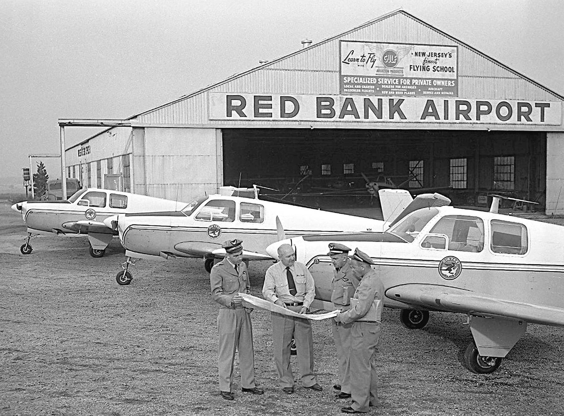
A circa 1960s photo of 4 unidentified men & 3 Beech Bonanzas in front of the Red Bank Airport hangar.

A circa 1966 photo of Ed Drury's nephew John Drury in front of N16181, a beautiful 1936 Stinson SR-8E at Red Bank Airport.

The 1967 NY Local Aeronautical Chart (courtesy of Mike Keefe) depicted Red Bank Airport as having a 2,600' paved runway.
The 1968 Flight Guide (courtesy of Robert Levittan) depicted Red Bank as having a single 2,650' paved Runway 9/27,
and a parallel taxiway on the north side.
A ramp & 3 small buildings were depicted on the northeast corner of the field.

A circa 1960s photo by Chuck Maire of a Beech Bonanza in front of a Red Bank Airport hangar.
Chuck Maire recalled, “I received my private pilots license at Red Bank Airport in 1969 from Lou Miller the local examiner.”

A circa 1960s photo by Chuck Maire of a Suburban Airlines DHC Twin Otter at Red Bank Airport.

A circa 1970 aerial view looking southeast at Red Bank Airport (courtesy of Douglas Wright).

A circa 1970 closeup of the northeast corner of Red Bank Airport (courtesy of Douglas Wright).
In 1970, Red Bank Airport was improved with the construction of a small terminal building for Air Taxi.
The newly paved Runway 9/27 ran to within a few feet of the street bounding either side of the airport property.

The January 1972 Flight Guide (courtesy of Chris Kennedy) depicted Red Bank as having a single 2,650' paved Runway 9/27,
and a parallel taxiway on the north side.
A ramp was depicted on the northeast corner of the field, with a single building (a hangar?).

The last aeronautical chart depiction which has been located of Red Bank Airport was on the June 1972 NY Sectional Chart.
It depicted Red Bank Airport as having a 2,600' paved runway.
Patrick Faley recalled, "While Red Bank Air Taxi was the 1st scheduled passenger service out of the airport,
it was not the only or most successful service.
Reading PA based Suburban Airlines made Red Bank a sort of a hub for several years, with service to JFK & Newark.
The airline flew both 9-seater Britton-Norman Islanders & 19 seat DHC Twin Otters.
After several fatal crashes at or near the airport, including a Suburban crash that killed both crew & all 7 passengers,
the airport basically was forced to close."
In spite of the recent improvements in the airport's facilities, Red Bank was closed at some point between 1972-73,
after suffering a string of accidents including the deaths of a couple of high profile local businessmen.
The resultant negative attention from the community, plus the increasing value of the land,
prompted the airport to be closed & the land redeveloped for commercial real estate.
By the time of the January 1973 Sectional Chart (courtesy of Ron Plante), Red Bank Airport was no longer depicted.

The 1981 USGS topo map depicted the airfield as having a single 2,600' east/west runway.
Red Bank Airport was still depicted on the 1986 USGS topo map,
even though it had apparently been closed by that point for several years.
The 1995 USGS aerial photo showed that the site of Red Bank Airport had been redeveloped,
with several large office buildings covering the former airport.

A 2005 photo by Tom Rutherford of the remains of the taxiway at the site of Red Bank Airport
(note the remains of the yellow centerline stripe at the lower-left corner).
Tom reported, “I work on the site of the Red Bank Airport.
Unfortunately, approximately 5 years ago, a doctor's office was built over the old section of the remaining runway,
though there is still a taxiway from the former airport but it is badly broken up.
You can easily tell that it is a taxiway because there are still yellow markings indicating the middle of the taxiway.”
Joe Strickland reported in 2006, “The terminal buildings were at the Shrewsbury Avenue end of the airport.
At this time there is a McDonalds, Gas Station, Rite Aid, and Wendy’s were the terminal was.
There are a few of the original building still there, although they have been heavily renovated.
These building are on the Apple Street side towards Shrewsbury Avenue.”
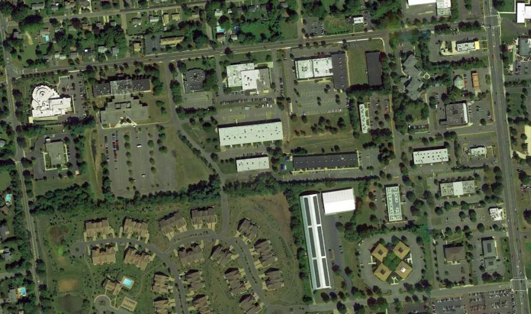
A 9/6/13 aerial photo showed several office buildings covering the site of Red Bank Airport.
Amazingly, a 600' long segment of the taxiway asphalt still remained visible in the bushes behind the parking lot of one building, in the center-right of the photo.

A 4/16/17 photo by John Drucker of the remains of the taxiway at the site of Red Bank Airport (note the remains of the yellow centerline stripe).

A 4/16/17 photo by John Drucker of the powerline stanchions adjacent to the site of Red Bank Airport.
John reported, “One item that's rarely if at all mentioned are the high tension power wires to the east of the runway.
The wires were so close to the end of the runway that the power company, Jersey Central Power & Light lowered them for a short distance down the centerline & to either side of the runway.
The 3 low stanchions & wires still remain today behind an office building & the Circle Chevrolet car dealership as a testament of the airport's existence.”
The site of Red Bank Airport is located southwest of the intersection of Shrewsbury Avenue & Apple Street.
____________________________________________________
Or if you prefer to contact me directly concerning a contribution (for a mailing address to send a check),
please contact me at: paulandterryfreeman@gmail.com
If you enjoy this web site, please support it with a financial contribution.
____________________________________________________
This site covers airfields in all 50 states.