Abandoned & Little-Known Airfields:
Pennsylvania: Northeastern Philadelphia area
© 2002, © 2025 by Paul Freeman. Revised 11/6/25.
This site covers airfields in all 50 states: Click here for the site's main menu.
____________________________________________________
Please consider a financial contribution to support the continued growth & operation of this site.
Budd Factory Airfield (revised 1/26/20) - Bustleton Field / William Penn Airport / Boulevard Airport (revised 10/15/22)
Somerton Airport / Flying Dutchman Field (revised 11/6/25)
____________________________________________________
Somerton Airport / Flying Dutchman Field, Philadelphia, PA
40.11, -75.02 (Northwest of Northeast Philadelphia Airport, PA)
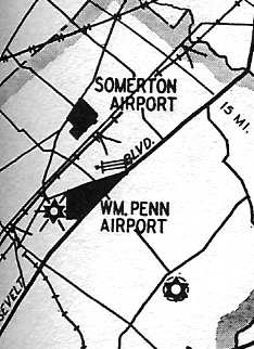
Somerton Airport, as depicted on the Philly Chamber of Commerce's
1930 "Aviation Map of the Philadelphia Metro District" (courtesy of Tom Beamer).
“Somerton Airport was founded by [Ernest] Buelh in 1928”
according to a circa 1930s brochure for Flying Dutchman Air Service (courtesy of Mark Hess).
The earliest depiction of Somerton Airport which has been located
was on the Philly Chamber of Commerce's 1930 "Aviation Map of the Philadelphia Metro District" (courtesy of Tom Beamer).
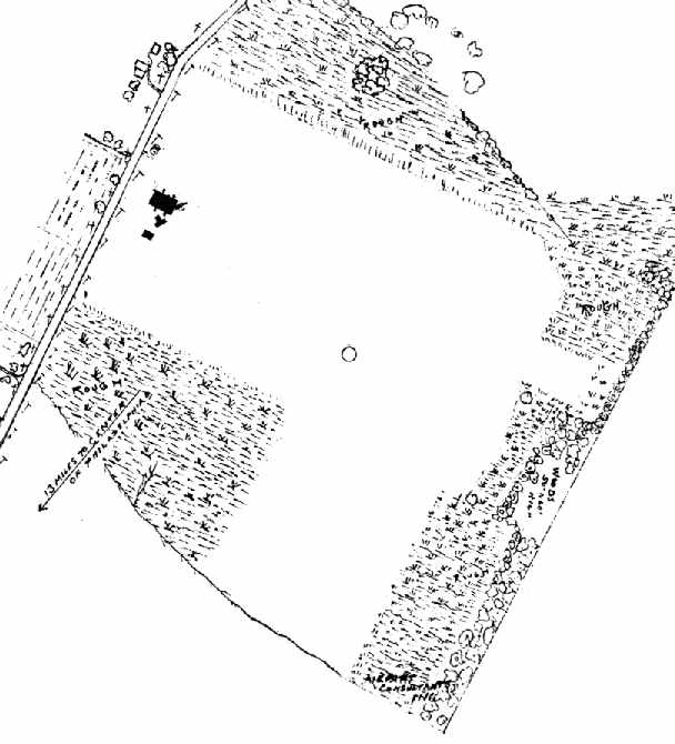
The airfield layout of "Somerton (Flying Dutchman) Field",
from the 1930 book "Philadelphia Aeronautical Center of the East"
(courtesy of the George H. Stuebing Collection of the Delaware Valley Historical Aircraft Association).
The directory described the field as consisting of an 115 acre irregularly shaped field.
The field was said to be owned & operated by Ernest Buehl.
One metal hangar & one wood hangar were depicted on the west side of the field.
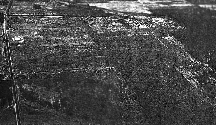
An aerial photo looking north at "Somerton (Flying Dutchman) Field"
from the 1930 book "Philadelphia Aeronautical Center of the East"
(courtesy of the George H. Stuebing Collection of the Delaware Valley Historical Aircraft Association).
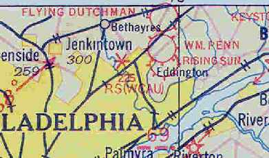
The earliest aeronautical chart depiction which has been located of Flying Dutchman Field
was on the May 1932 J-18 Washington D. C. Airway Map (courtesy of Chris Kennedy).
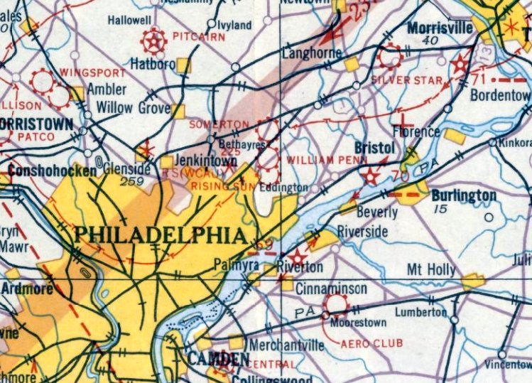
It was depicted as Somerton Airport on the August 1932 NY Sectional Chart.
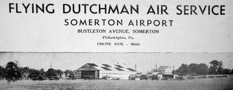
An undated photo of Somerton Airport from a circa 1930s brochure for Flying Dutchman Air Service (courtesy of Mark Hess & Tom Clarke).
depicted more than a dozen single-engine aircraft lined up in front of a checkerboard-pained hangar.
The brochure said, “The Flying Dutchman, otherwise known as Ernest Buehl, owner & operator of the Flying Dutchman's Air Service, Somerton Airport,
has a record of personal achievement & success which has led many to call on him for inaugural appearance of the new future 'The Art of Flying'.
With 22 years of experience in active aviation duties, and one plane,
Mr. Buehl has today established one of the largest airports in the east which now has a capacity to store over 45 planes.”
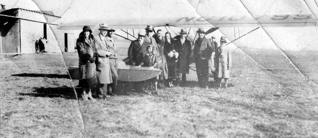
A circa 1934 photo of William France & a crowd of unidentified people in front of an unidentified parasol monoplane at Flying Dutchman Airport (courtesy of Bill France).
According to his son, Bill France, “He had won a prize of an airplane ride & this photo was taken of him at the flight.
He is the young boy in the center of the photo in the leather cap. His father, Albert France, with glasses, is directly behind him.”
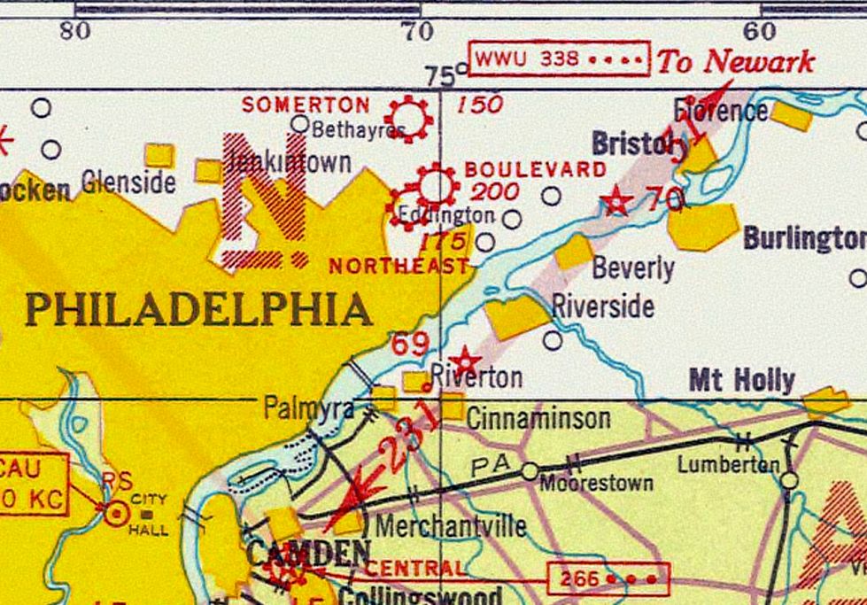
The 1935 Washington Sectional Chart (courtesy of Roger Connor) depicted Somerton Airport
in close proximity to Boulevard Airport & Northeast Philadelphia Airport.
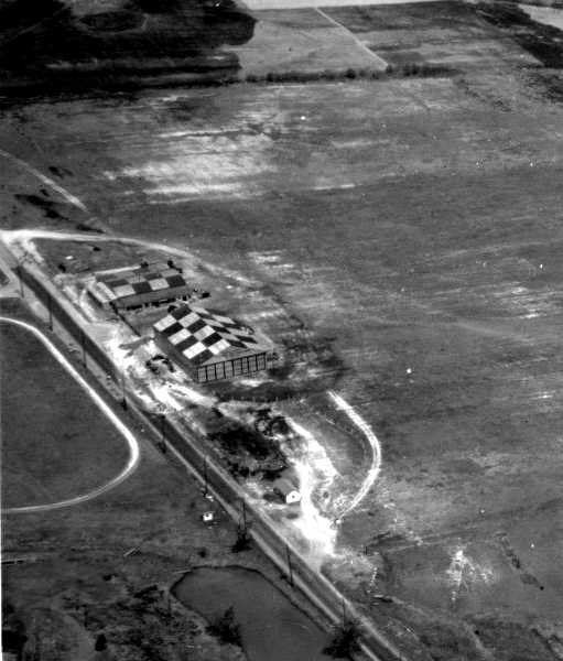
A 4/30/36 aerial view looking northeast at Somerton Airport
showed 2 hangars with checkerboard-painted roofs on the west side of an open grass field.
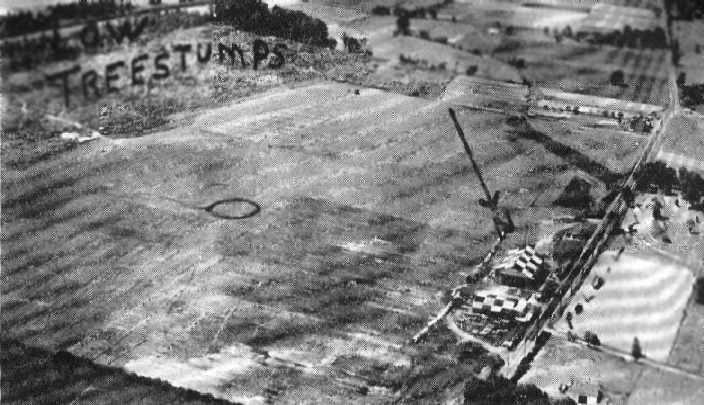
An aerial view of Somerton Airport, looking south,
from The Airport Directory Company's 1937 Airports Directory (courtesy of Bob Rambo).
The directory described Somerton Airport as having a 2,900' x 2,600' sod all-way landing area.
Two checkerboard-roofed hangars were depicted along the northwest side of the field.
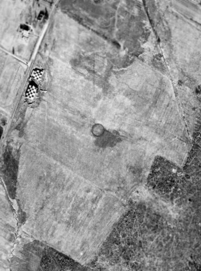
A 1/5/38 aerial view of Somerton Airport showed the circular airport symbol in the center of the grass field,
with 2 checkerboard-painted hangars on the west side of the field,
around which were parked 4 light aircraft.
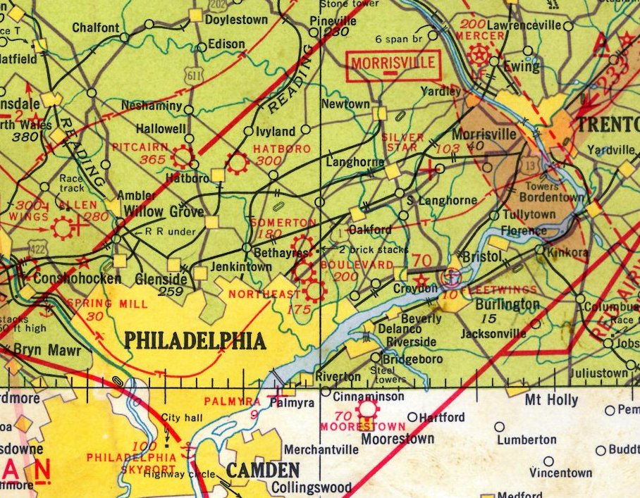
The March 1940 NY Sectional Chart (courtesy of Tim Zukas) depicted Somerton as a commercial/municipal airport.
In May of 1941 the "Brewster Flying Club" was organized at Somerton Airport.
It was comprised primarily of individuals who worked at the Brewster Aircraft plant in nearby Johnsville.
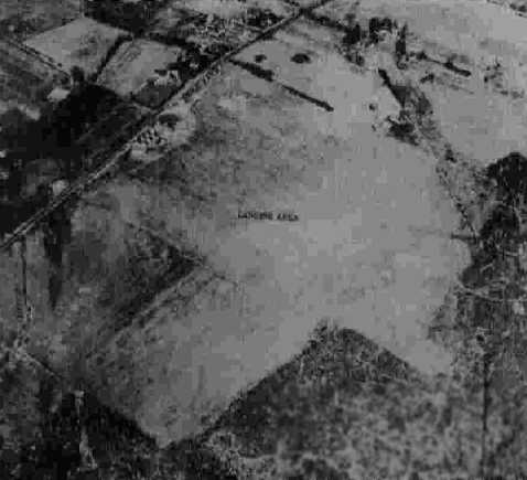
The last photo which has been located of Somerton Airport
was a 10/28/42 aerial view looking northeast from the 1945 AAF Airfield Directory (courtesy of Scott Murdock).
It depicted the field as an open grass area.
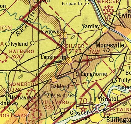
The November 1942 NY Sectional Chart (courtesy of Ron Plate)
depicted Somerton as a commercial/municipal airport.
The 1945 AAF Airfield Directory (courtesy of Scott Murdock) described Somerton Airport
as an 116 acre rectangular property within which was a sod all-way landing area, with the longest dimension being 2,500' north/south.
The field was said to have 2 hangars, with the largest being a 130' x 50' metal structure.
Somerton was described as being privately owned & operated.
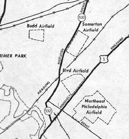
A 1946 USGS map depicted the outline of Somerton Airfield,
as well as several nearby airports: Budd Airfield, Boulevard Airfield, and Northeast Philadelphia Airfield.
In 1947, the Brewster Flying Club moved to nearby Warrington Airport & took on the name of "Warrington Flying Club".
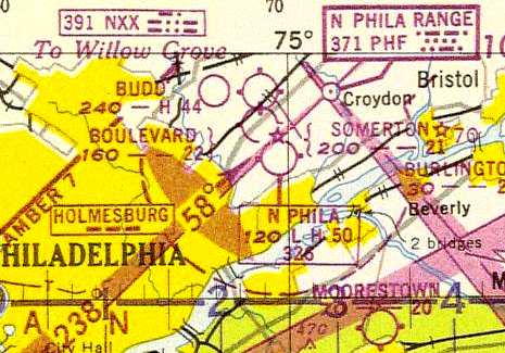
The 1947 Washington Sectional Chart described Somerton Airport as having a 2,100' unpaved runway.
The operator of Somerton Airport, Ernest Buehl,
had opened Buehl Field in nearby Bensalem at some point between 1945-49.
Wayne Klaw reported, “My Father Marc Klaw worked as a flight instructor For Ernie Buehl at Somerton Airport (The Flying Dutchman) [starting in] 1947.”
A 1948 aerial view depicted a total of 10 light aircraft parked around Somerton's checkerboard-painted hangars.
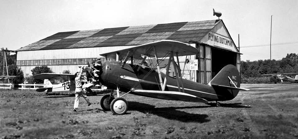
A 1949 photo by Marc Klaw (courtesy of Wayne Klaw) of Walt Maucher hand-propping R. Pitcairn
in a surplus Naval Aircraft Factory N3N-3 Yellow Peril in front of the Flying Dutchman hangar at Somerton Airport.
Wayne observed, “The blimp-shaped weather vane on the hangar was a well known icon of Somerton Airport.”
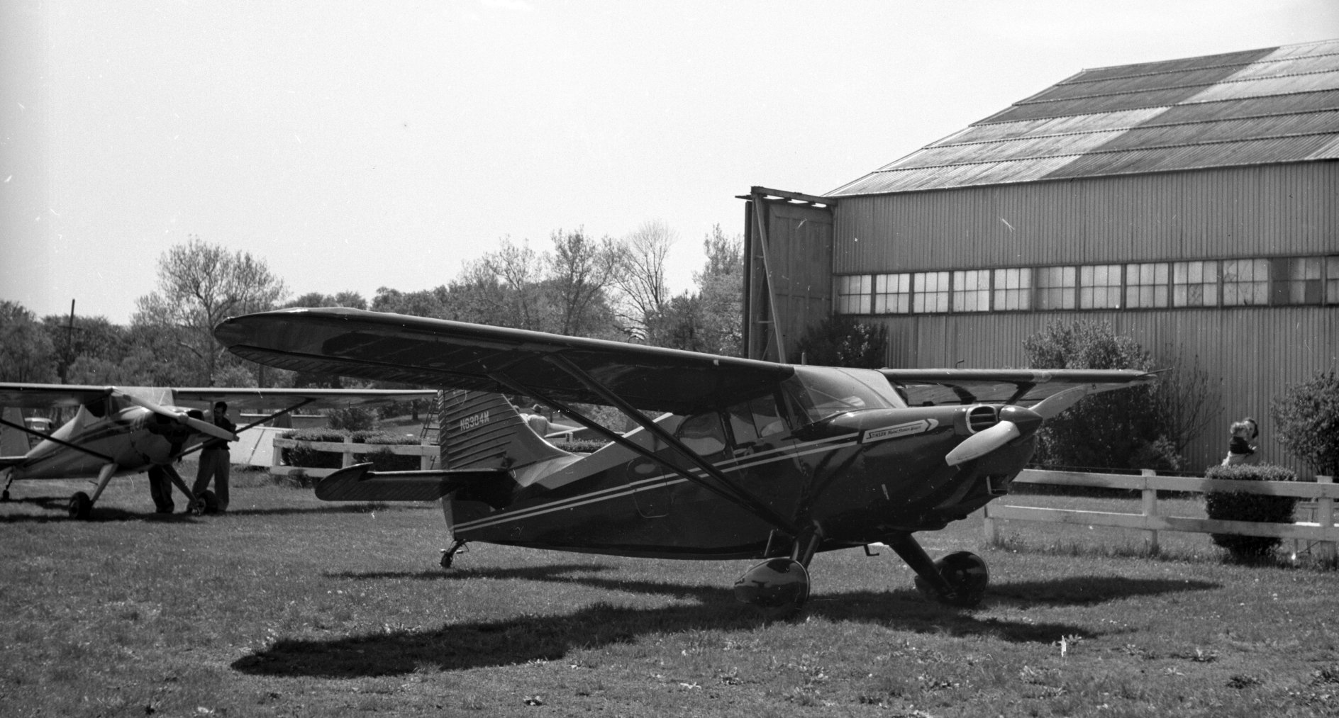
A 5/21/50 photo by Raymond Blood of a Stinson in front of a Flying Dutchman Field hangar (courtesy of Jen Carlson).
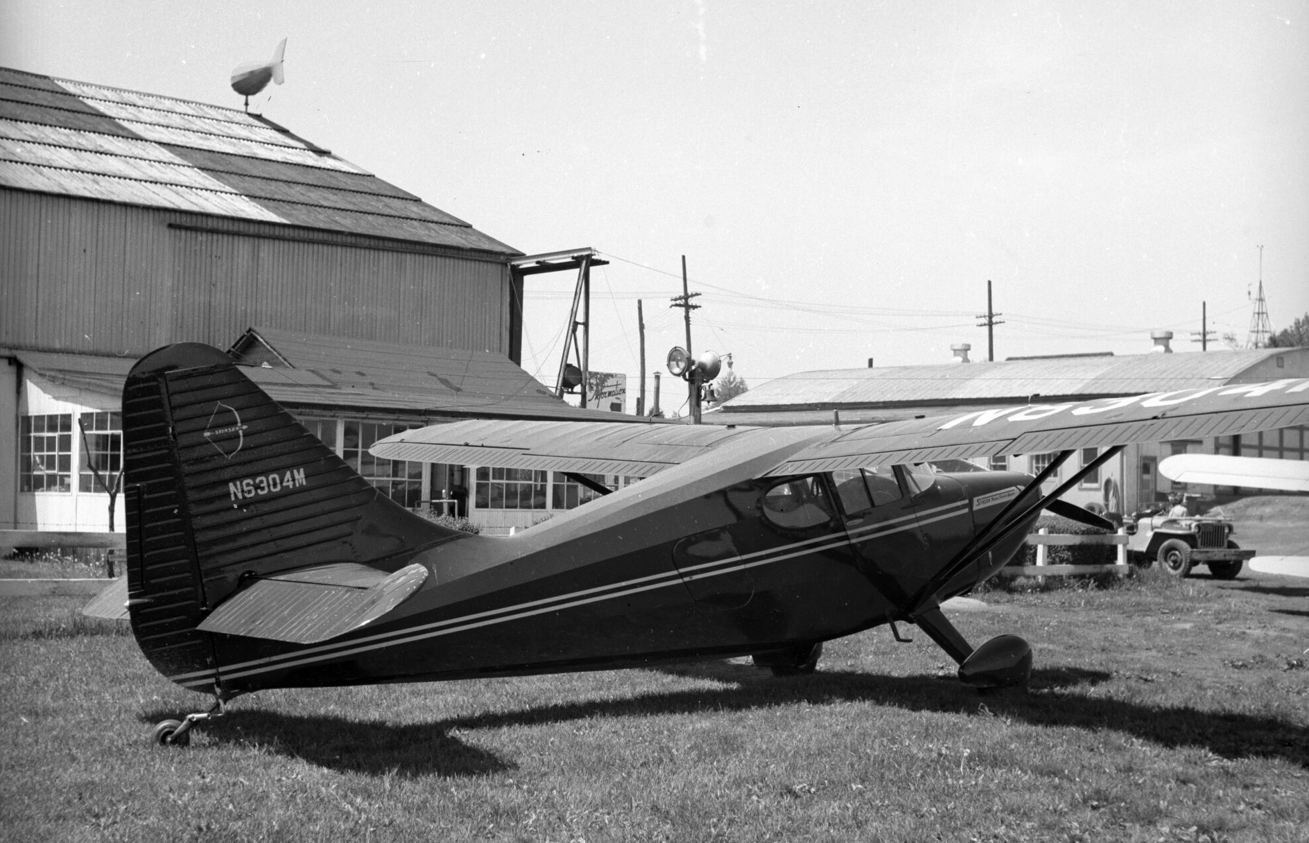
A 5/21/50 photo by Raymond Blood of a Stinson in front of a Flying Dutchman Field hangar (courtesy of Jen Carlson).
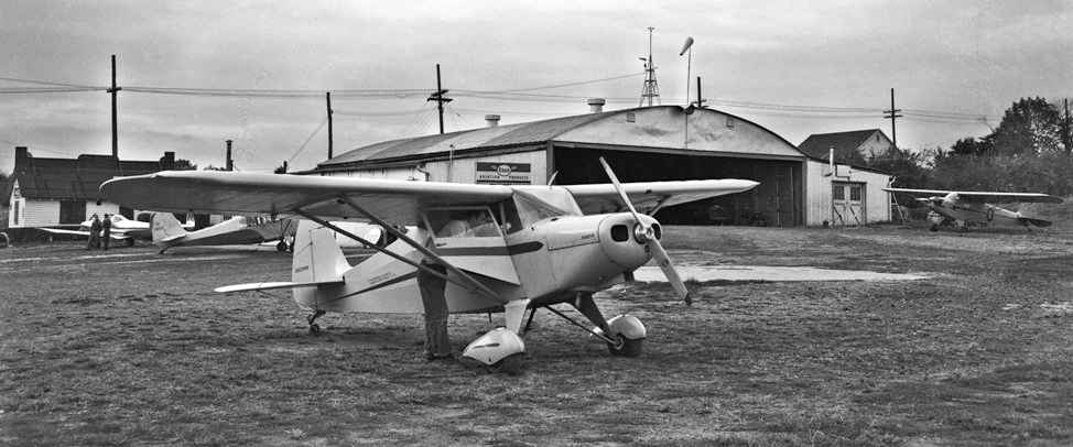
A 1950 photo by Marc Klaw (courtesy of Wayne Klaw) of a Piper PA-16 Clipper in front of a Somerton Airport hangar.
According to Wayne Klaw, a twin Cessna T50 was used at Somerton “during light cargo charter for Philco” in 1950.
My father told me about flying the Philco charters during the Korean war.
I think there was a Catholic High School in Philadelphia which had an aviation club run by a Priest.
Mac [Bob McCarthy] & Tom [Oschesky] plus several others learned to fly at Somerton while in that aviation club.”
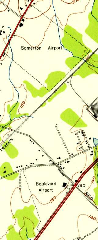
The 1950 USGS map depicted Somerton Airport as an irregularly-shaped property with several buildings along the west side.
It also depicted Boulevard Airport in close proximity.
A 1950 aerial view depicted only 3 aircraft at Somerton, a marked decreased from the 1948 photo.
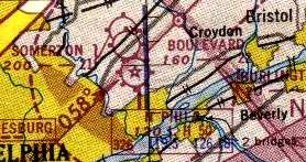
The last depiction of Somerton Airport as an active airport which has been located
was on the 1951 Washington Sectional Chart (courtesy of Mike Keefe),
which described the field as having a 2,100' unpaved runway.
Wayne Klaw reported, “My Father Marc Klaw worked at Somerton Airport until they ceased operations which I think was in 1952.”
According to www.buehlfield.info/flying/somerton,
in February 1952 a picture appeared in “The Breeze” titled “Farewell to Somerton Airport as Veteran Plane Leaves for...”.
The accompanying brief article stated that Somerton Airport closed on 2/23/52
when Ernie flew his 1927 Challenger from there to “Buehl Field at Penndel east of the Boulevard at Street Road.”
A 1953 aerial photo showed that houses had begun to cover the northern half of the former airport property,
and both hangars had been removed at some point between 1950-53,
with only the foundation remaining of the larger hangar.
The airport circle marking remained intact in the center of the field.
Somerton Airport was no longer depicted at all on the 1955 Washington Sectional Chart (courtesy of Mike Keefe).
A 1958 aerial photo showed that the residential construction had extended further to the south,
covering the airport circle marking.
By the time of a 1965 aerial photo, the site of Somerton Airport had been covered in residential development,
and not a trace appeared to remain of the former airport.
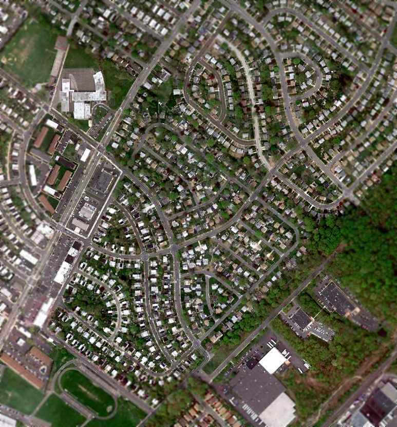
A 4/12/10 aerial view no longer depicted any trace of the former Somerton Airport.
The site of Somerton Airport is located east of the intersection of Bustleton Avenue & Tomlinson Road.
____________________________________________________
Bustleton Field / William Penn Airport / Boulevard Airport, Philadelphia, PA
40.093, -75.025 (Northwest of Northeast Philadelphia Airport, PA)
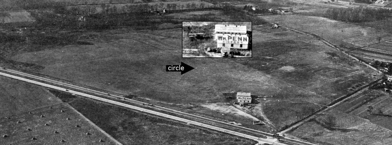
A circa 1928 aerial view looking west at William Penn Airport (courtesy of Tom Clarke).
This airport evidently went through a series of 3 names during its 33 year lifespan.
According to a historical marker erected on 5/19/18 by the Friends of Northeast Philadelphia History, “Bustleton Field, First US Air Mail Delivery, 5/15/18.
The first regularly-scheduled US Post Office Air Mail delivery took place here, midpoint of the NY-Philadelphia-Washington Air Mail route, on 5/15/18.
Bustleton Field was the chief US Air Mail maintenance & repair depot from 1918-21.”
According to “Living in the Past”, an article by Harry Silcox in the 10/9/08 issue of the Northeast Times,
the William Penn Airport was begun in 1928 by Chester Larner, C.C. Tutwiler, H.W. Tutwiler & George Hutchinson.
Located at Red Lion Avenue & Roosevelt Boulevard, and operated by the Interstate Flying Corp.,
the 80-acre field had 2 runways & 2 hangars situated next to the Boulevard.
It had 6 all-metal, modern planes available for daily use.
There was a small restaurant across Red Lion Road that provided food & beverages for visitors.
The earliest depiction which has been located of William Penn Airport was a circa 1928 aerial view (courtesy of Tom Clarke).
It depicted an airport office building (with “Wm. Penn Airport” painted on its roof) & a biplane on the northeast side of a grass airfield,
with an airport circle marking in the center.
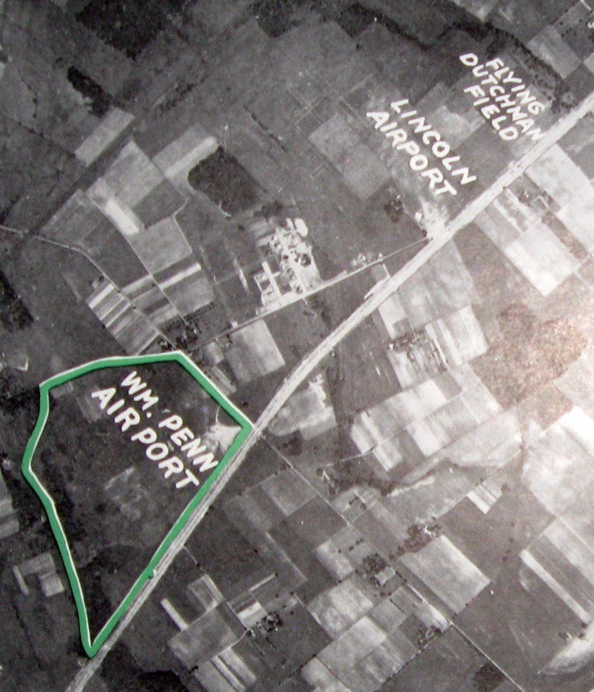
An undated aerial view of William Penn Airport (along with nearby Lincoln Airport & Flying Dutchman Field) from a 1928 report “Location of Airport, Philadelphia” (courtesy of Fred Kelso).
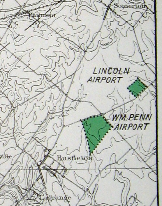
William Penn Airport (along with nearby Lincoln Airport) from a 1928 report “Location of Airport, Philadelphia” (courtesy of Fred Kelso).
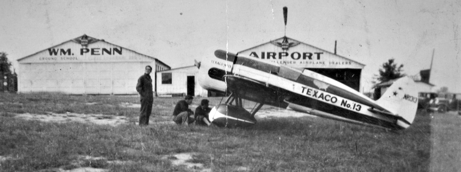
A 1929 photo of mechanic William Rodriguez in front of Travel Air Type R Mystery Ship Texaco #13, NR1313, and the William Penn Airport hangars (courtesy of Robert Rodriguez).
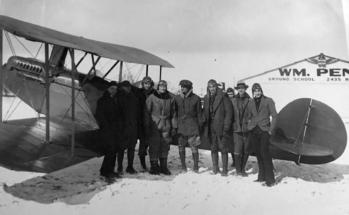
A 1929 photo (courtesy of Bill Engle Jr.) of a gathering of pilots (including his father William H. Engle, 4th from left)
who were helping PA Game Warden Ed Stucke by winter feeding wild game, in front of a biplane & the William Penn Airport hangar.
William Penn Airport, as depicted on the Philly Chamber of Commerce's 1930 "Aviation Map of the Philadelphia Metro District" (courtesy of Tom Beamer).
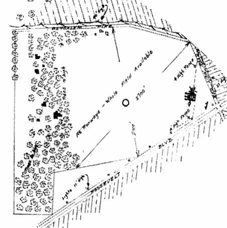
The airfield layout of William Penn Airport, from the 1930 book "Philadelphia Aeronautical Center of the East"
(courtesy of the George H. Stuebing Collection of the Delaware Valley Historical Aircraft Association).
The directory described the field as consisting of an 80 acre field, measuring 2,700' northeast/southwest by 2,100' north/south.
The field was said to be owned & operated by the Interstate Flying Corporation, which also provided sales & service of Fairchild planes.
Two 60' x 50' metal hangars were depicted on the east side of the field, along Roosevelt Boulevard.
The earliest aeronautical chart depiction which has been located of William Penn Airport
was on the May 1932 J-18 Washington D. C. Airway Map (courtesy of Chris Kennedy).
It depicted William Penn Airport sandwiched in between Flying Dutchman Airport & Rising Sun Airport.
The earliest Sectional Chart depiction which has been located of William Penn Airport was on the August 1932 NY Sectional Chart.
The airport was acquired by Dick Bircher in 1933, according to his great-grandson, John Bircher III,
and was renamed Boulevard Airport.
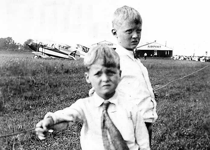
A circa 1933 photo (courtesy of Dave Carney) of Philip & Charlie Carney in front of several unidentified biplanes & 2 hangars marked “Boulevard Airport”.
Boulevard Airport was described in the 1934 Department of Commerce Airport Directory (according to Chris Kennedy)
as having a 2,400' x 2,100' sod rectangular field.
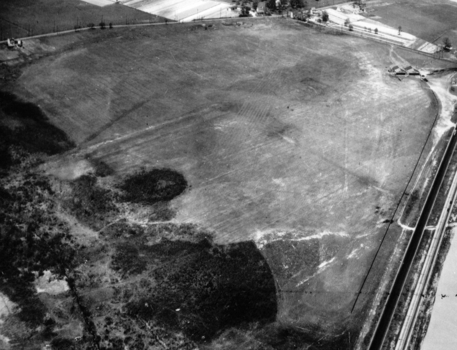
A 4/30/36 aerial view looking north at Boulevard Airport (from the Dallin Aerial Survey Collection, courtesy of Barbara Hall of the Hagley Museum & Library).
It depicted the field as an irregularly-shaped grass field with 2 hangars along the east side.
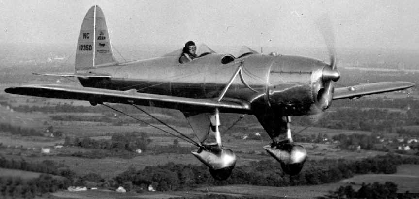
A photo of Boulevard Airport owner Dick Bircher in a beautiful Ryan STA (circa mid-to-late-1930s, courtesy of John Bircher III).
John Bircher III recalled, "My Grandfather, John Bircher was the son of Dick Bircher & learned to fly before he could drive at Boulevard.
I have pictures of several of the aircraft they had, as well as photos of the airport fire that ravaged most of the buildings."
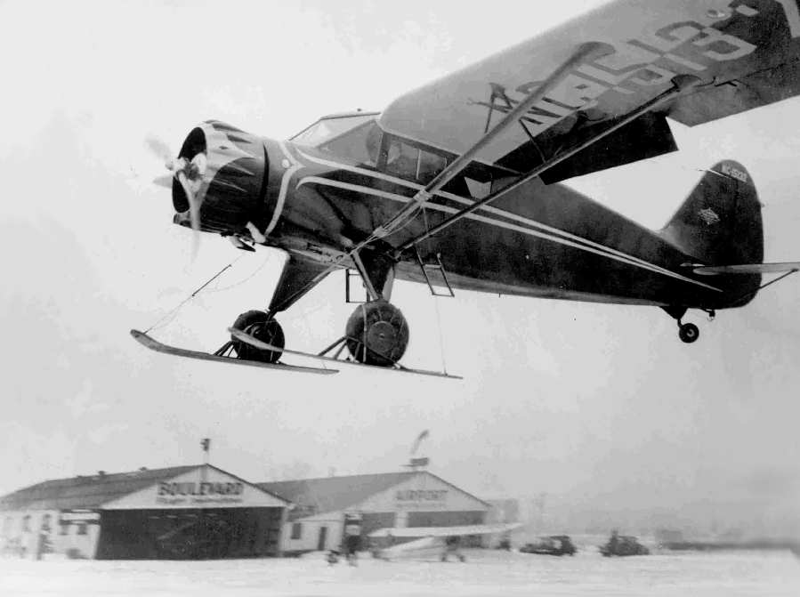
A fabulous circa mid-to-late-1930s photo (courtesy of John Bircher III) of a ski-equipped Stinson Reliant coming in to land at a snowy Boulevard Airport,
with 2 hangars visible in the background.
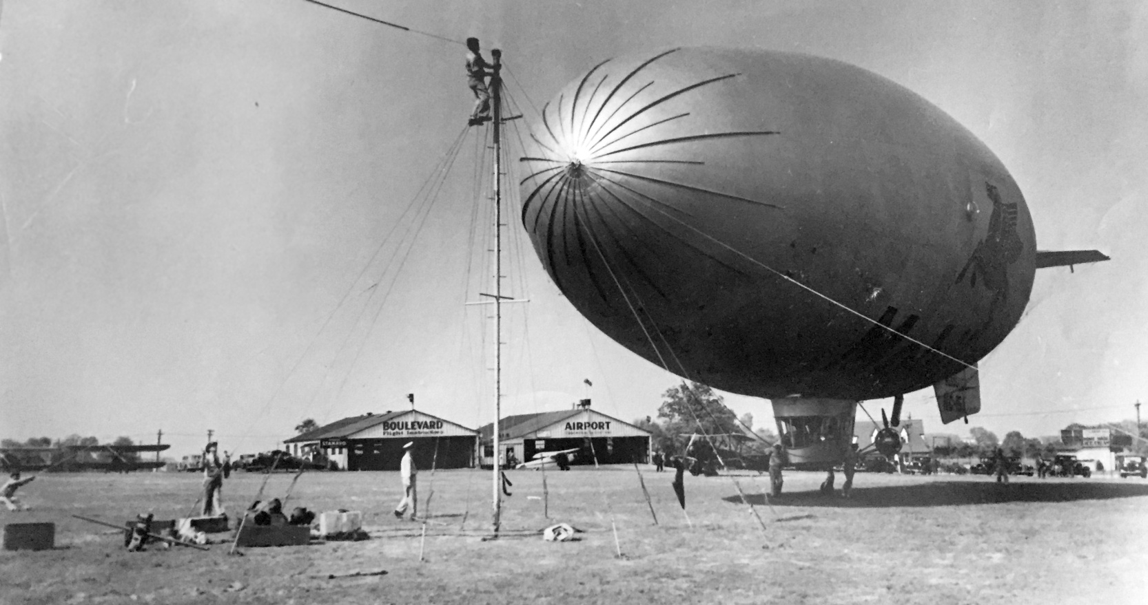
A circa 1930s photo (courtesy of Michael Ruby) of the Goodyear TZ blimp Resolute NC-15A (with a Mobile Pegasus logo) moored at Boulevard Airport,
with several biplanes & monoplanes visible in the background.
Michael Ruby reported, “The blimp experts said that the Resolute went on a tour in the summer of 1936.
The ship traveled from Akron OH to areas throughout NY & New England. Boulevard Airport must have been a stop-over.”
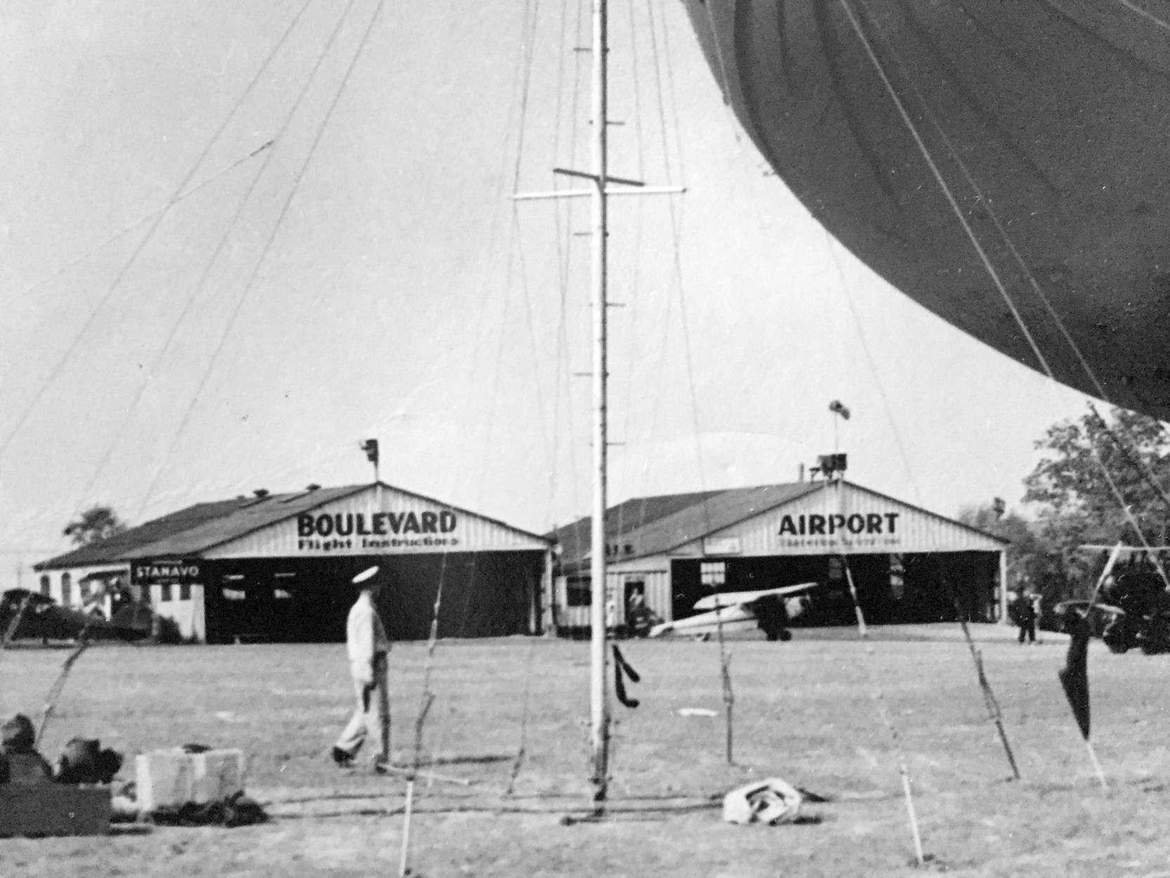
A closeup of the circa 1930s photo (courtesy of Michael Ruby) of the 2 Boulevard Airport hangars behind the moored blimp.
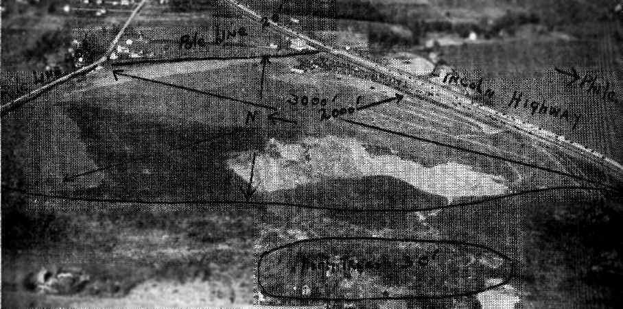
An aerial view of Boulevard Airport, looking northeast,
from The Airport Directory Company's 1937 Airports Directory (courtesy of Bob Rambo).
The directory described Boulevard Airport as having an 85 acre sod landing area, measuring 3,000' x 2,000'.
The aerial photo in the directory depicted 2 hangars along the east side of the field,
on the west side of Lincoln Highway (known today as Roosevelt Boulevard).
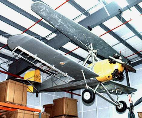
The Herrick HV-2A, test-flown at Boulevard Airport in 1937.
In 1937, Boulevard Airport was the site of early flight testing of a vertical takeoff convertiplane designed by Gerard Herrick.
The Herrick HV-2A was constructed by Heath Aircraft to Herrick's specifications,
combining an innovative gyroplane rotor system with a conventional airplane.
George Townson, a young & enthusiastic test pilot, flew the aircraft throughout its test program.
The HV-2A's new rotor system proved to be much safer than the one installed on previous Herrick convertaplanes.
Townson made the 1st conversion from fixed-wing to gyroplane mode in April 1937 at the Boulevard Airport.
By the end of the year, he had made more than 100 conversions in the aircraft.
On one flight, Townson experienced heavy vibration after converting into gyroplane mode
and set down in someone's backyard, but after making a few adjustments, he took off again,
remaining in gyroplane mode for the rest of the flight.
By December 1937, Herrick’s business was running out of money.
The main problem was the instability of his gyrocopter.
Herrick, out of money, was forced to abandon the HV-2A developmental program at the end of 1937.
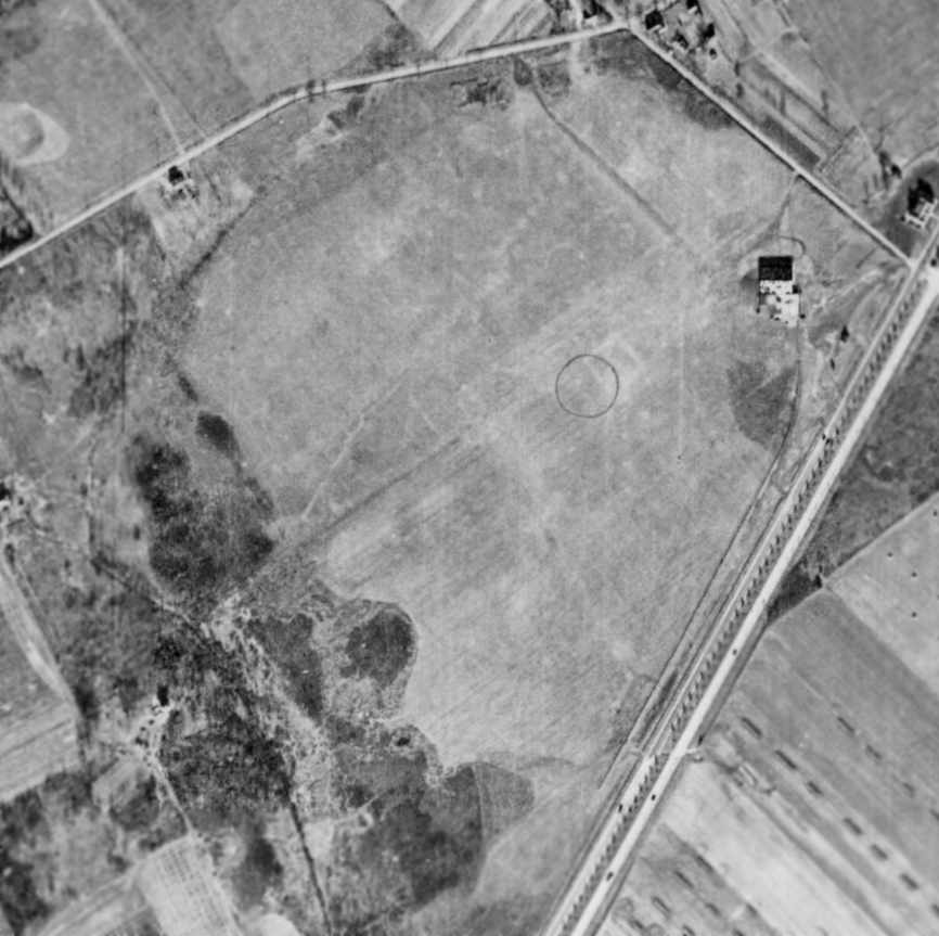
A 1/5/38 aerial view of Boulevard Airport showed the circular airport symbol in the center of the grass field, with a single hangar on the northeast corner.
There were no aircraft visible on the field.
The March 1940 NY Sectional Chart (courtesy of Tim Zukas) depicted Boulevard as a commercial/municipal airport.
John C. Bircher III recalled that Boulevard Airport "was closed during the war [WW2],
and Dick & Granddad moved the cadet flight school to a farm Dick bought in Gettysburg."
The temporary wartime closure of the airport was apparently a result of wartime security concerns,
as was the case at many other small civil airports along the coasts during the war.
Boulevard Airport was not depicted at all on the 1943 NY Sectional Chart (courtesy of Chris Kennedy).
In 1943, Gerald Herrick received special permission from the government
to experiment at the airport with his improved gyrocopter, the Herrick HV-3.
This model was a coaxial helicopter that did not come to fruition,
as he had little success with increasing the stability of the plane.
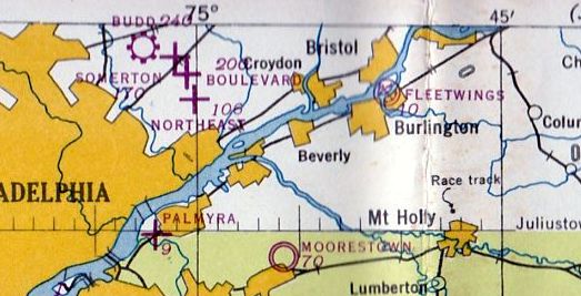
Boulevard Airport was depicted as an auxiliary airfield on the May 1944 Washington Sectional Chart (courtesy of Ron Plante).
Boulevard Airport was not listed among active airfields in the 1945 AAF Airfield Directory (courtesy of Scott Murdock).
Boulevard Airport reopened after WW2.
Dean Westover reported in 2003, "I know that Boulevard Airport was open in August of 1946. I have purchased a 1946 Aeronca Chief.
During a title search I found that it was delivered to Carl Norton of Boulevard Airport on 8/12/46."
A 1946 USGS map depicted the outline of Boulevard Airfield,
as well as several nearby airports: Budd Airfield, Somerton Airfield, and Northeast Philadelphia Airfield.
The 1947 Washington Sectional Chart described Boulevard Airport as having a 2,200' unpaved runway.
David Leidel observed of Boulevard Airport, "I know it was operational in 1947,
as I have a photo of myself standing near George Villsmeyer's airplane when I was 2 years old."
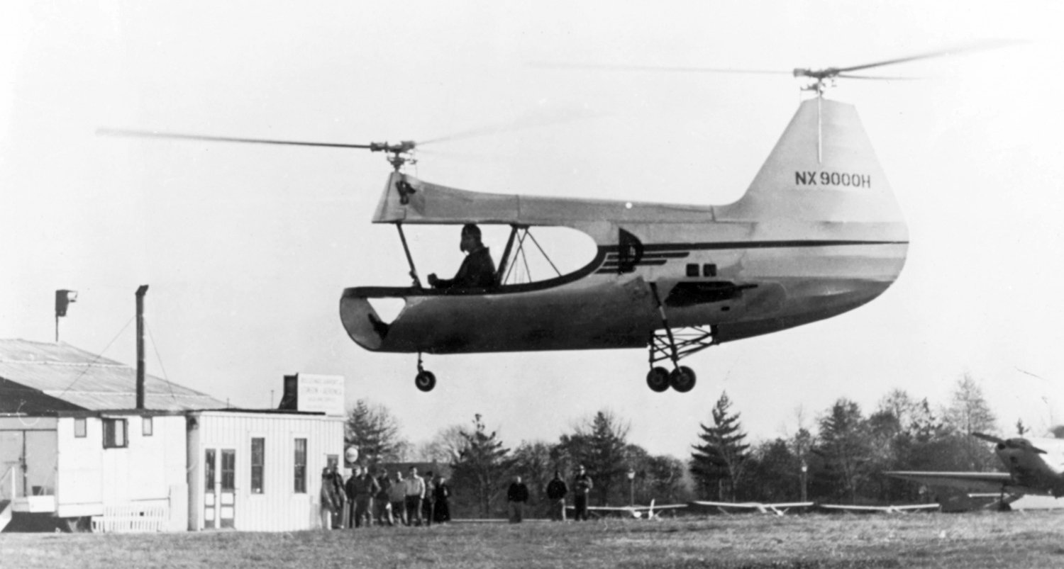
A circa 1947-48 photo of the sole HERC JOV-3 tandem helicopter, NX9000H, being tested at Boulevard Airport.
A 1948 aerial view of Boulevard Airport showed a checkerboard-painted hangar on the eastern corner, 6 individual T-hangars on the northeast,
and 6 light aircraft on the southeast side.
The airport circle marking was in the center of the field.
In 1949, Gerard Herrick proposed a convertiplane with rotor-mounted ramjets,
but this proposal also did not attract any investors.
A 1950 aerial view of Boulevard Airport did not show any aircraft parked on the field (but it did show a single light aircraft flying low over the field).
The airport circle marking had been removed at some point between 1948-50, but the field & hangars otherwise remained intact.
The 1950 USGS map depicted Boulevard Airport as an irregularly-shaped property with several buildings along the east side.
It also depicted Somerton Airport in close proximity.
The last depiction of Boulevard Airport as an active airport which has been located
was on the 1951 Washington Sectional Chart (courtesy of Mike Keefe),
which described the field as having a 2,200' unpaved runway.
Boulevard Airport was once again the site of vertical flight research & development work by yet another innovative small company.
The Helicopter Engineering Research Corporation conducted test flights at Boulevard Airport starting in 1951.
They produced the Jovair 4E Sedan & the Jovanovich JOV-3.
The company principals (including President D.K. Jovanovich) were formerly with the Piasecki Company (another Philadelphia-area company which pioneered vertical flight).
Boulevard Airport was closed on 10/4/51 (according to John Bircher).
An article in that night's issue of the Evening Standard newspaper (courtesy of John Bircher)
was entitled "Auction at City's 1st Airport Clears Way for Housing".
The article read, "The buildings & equipment of Boulevard Airport, Philadelphia's first,
were auctioned off yesterday to make way for a housing development on the site at Roosevelt Boulevard & Red Lion Road.
More than 100 bidders paid a total of $14,200 for the several hundred items in the sale.
The biggest price, $7,000, was paid for the 70' x 90' main hangar, which had originally been set up at what is now International Airport.
Issac Schlossbach of the Asbury Park Air Terminal paid $1,560 for 6 individual airplane hangars."
Ray Clark recalled, “Between when Boulevard closed & before it became a strip mall we used it for flying model planes.”
Boulevard Airport was no longer depicted at all on the July 1952 NY Sectional Chart (courtesy of Mike Keefe).
A 1953 aerial view showed that houses had been constructed along the northern portion of the Boulevard Airport site.
The 6 individual T-hangars had been removed at some point between 1950-53,
but the checkerboard-painted hangar remained standing.
The Helicopter Engineering Research Corporation was eventually acquired by McCulloch Motors Company in 1957.
A 1958 aerial photo showed that more houses had begun to cover the western half of the former airport property.
The checkerboard-pained hangar had been demolished at some point between 1953-58,
but its foundation was still evident on the eastern side of the site.
Thomas Delahanty recalled of Boulevard Airport, “I live in the housing development that was built at the airfield location.
I was born there in 1961 & moved back into the house that was built in 1958 after my parents left me the house in their will.
I remember playing 'army men' in the field amongst the old foundation of the demolished hangar
and even remember the remains of an old plane which sat on its belly next to it.
This was the 1960s & the old airfield was my whole world! Like a giant playground.
It was a different world back then & stay-at-home moms would let us kids run free all day in the summer time back there.
My oldest brother remembered the airport as well.
He used to fly model airplanes back there in the early 1960s.”
Aerial photos from 1965 & 1967 showed the field in much the same condition as 1958,
with houses covering the western half of the airport site,
and the hangar foundation remaining on the eastern corner.
By the time of an 1971 aerial photo, the site of Boulevard Airport had been covered with a shopping center & a residential development,
and not a trace appeared to remain of the former airport.
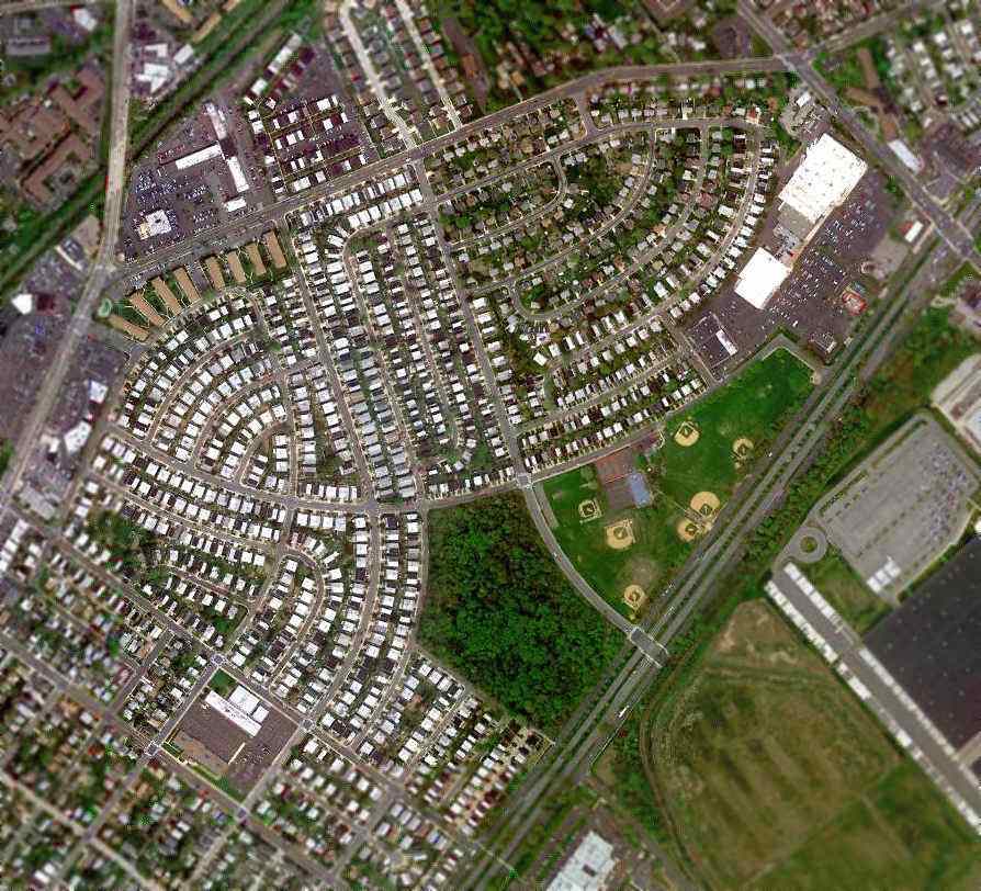
A 4/12/10 aerial view no longer depicted any trace of the former Boulevard Airport.
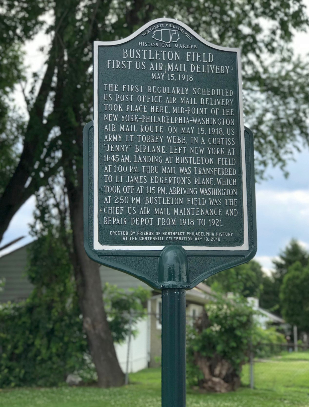
A 2018 photo by Tom Delahanty of the historical marker erected on 5/19/18 on the site of Bustleton Field
by the Friends of Northeast Philadelphia History for the occasion of the airport's Centennial Celebration.
Tom reported, “It's located on the southeast corner of Haldeman Avenue & Red Lion Road, next to the Wendy’s Restaurant.”
The site of Boulevard Airport is located on the west corner of the intersection of Roosevelt Boulevard & Red Lion Road.
____________________________________________________
Budd Factory Airfield, Philadelphia, PA
40.11, -75.04 (Northwest of Northeast Philadelphia Airport, PA)
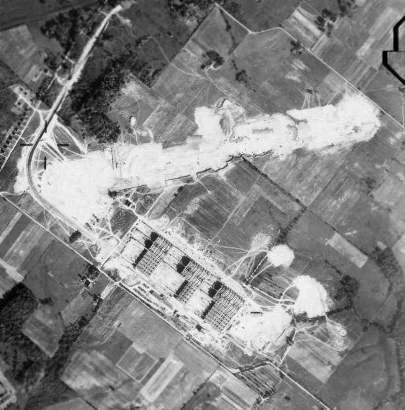
A 10/8/42 aerial view which appears to show the Budd Red Lion Factory while under construction,
with a single northeast/southwest runway also under construction.
The Edward G. Budd Manufacturing Company was a major manufacturer of railroad cars.
The Budd Company decided to apply their manufacturing experience
with stainless steel to the manufacturing of aircraft.
Their initial entry into the world of aeronautics was made in 1930
through the contract manufacture of aircraft wheels & stainless steel wing ribs.
The 1st complete aircraft designed & built by Budd was the BB-1 Pioneer amphibian,
a single example of which (NR749N) was built in 1931.
The Pioneer was powered by a single 210hp Kinner C-5 motor,
and used design concepts from the Savoia-Marchetti S-31.
Budd's stainless steel construction aircraft construction process was patented (US patent #2,425,498 in 1942).
Indeed this was the world's 1st stainless steel aircraft, truly making it a "Pioneer".
Budd's Red Lion Plant was built shortly after the start of World War II in 1942, on 572 acres of farmland in the Far Northeast section of Philadelphia.
The complex was built by the United States Government & was operated by the Budd Company.
The earliest depiction which has been located of the Budd Factory Airfield was a 10/8/42 aerial view,
which appeared to show the Budd Red Lion Factory while under construction,
with a single northeast/southwest runway also under construction to the north of the factory.
Another runway was eventually added, oriented Northwest/Southeast.
The Budd Airfield was not yet depicted on the November 1942 NY Sectional Chart.
The Budd Factory Airfield was opened in 1943, according to ExplorePaHistory.com.
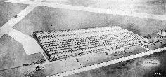
A circa 1940s artist's conception looking northeast at the Budd Red Lion Factory, with 2 runways visible behind the factory.
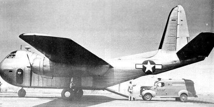
The Budd RB-1 Conestoga, manufactured in the Philadelphia plant.
During WW2, Budd again saw an opportunity to apply its stainless steel construction experience to aircraft once again,
and the result was the Budd RB-1 Conestoga cargo aircraft,
the 1st mass-produced aircraft constructed primarily of stainless steel.
The Conestoga was also significant in that it was the 1st modern military cargo aircraft
to adopt a configuration which has become the standard in post-WW2 military cargo aircraft,
with a high wing, and a rear ramp facilitating easy loading of cargo.
This is the exact configuration still used by almost all post-WW2 military cargo aircraft (C-123, C-130, C-17, etc.).
The 1st flight of the RB-1 Conestoga was in 1943, piloted by Guy Miller.
Initially 3 prototypes of the Conestoga were built.
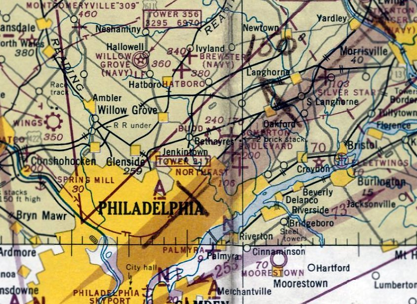
The earliest aeronautical chart depiction of the Budd airfield which has been located was on the May 1943 NY Sectional Chart.
It depicted Budd as a commercial/municipal airfield.
David Leidel recalled, "My father was a Flight Test Engineer on the RB-1 at Budd Field during the latter stages of WW2.
They had a lot of problems with the Budd ship & his flight log tells quite a tale."
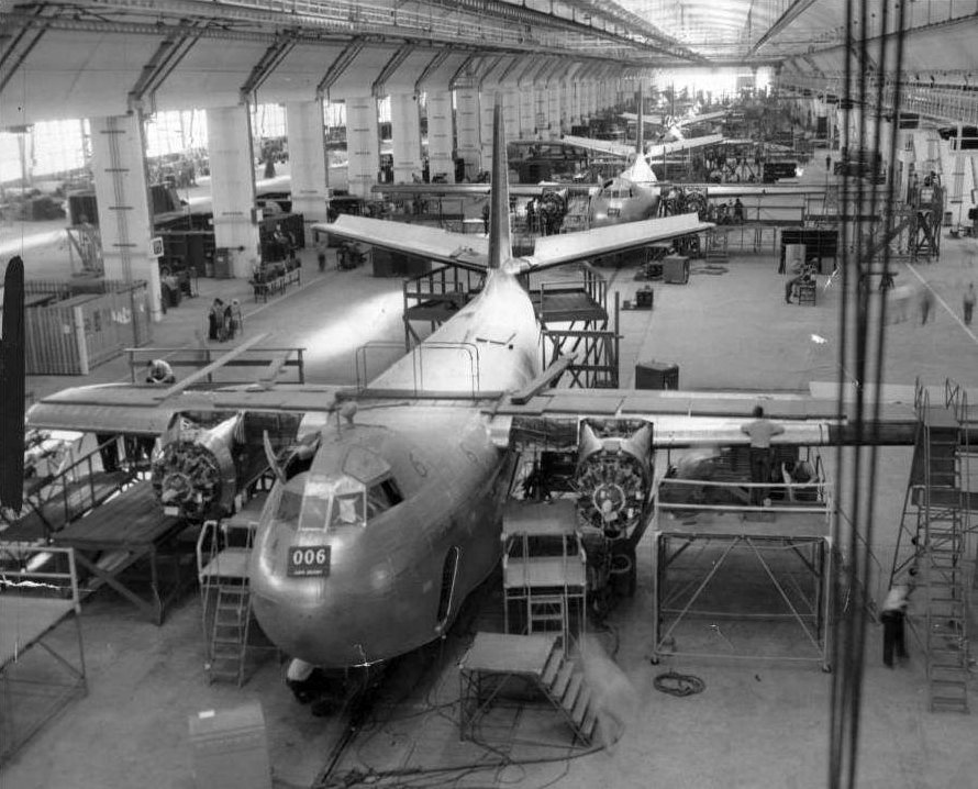
A circa 1943-44 photo of the interior of the Budd Red Lion Factory, showing the RB-1 Conestoga assembly line.
Unfortunately, the Conestoga was not a success, due to undesirable handling qualities.
A total of 17 examples of the RB-1 were produced by Budd for the Navy, the last of which was delivered in March of 1944,
and a further contract for 180 examples was canceled.
Budd's facility had the WW2 USAAF code of “BU”.
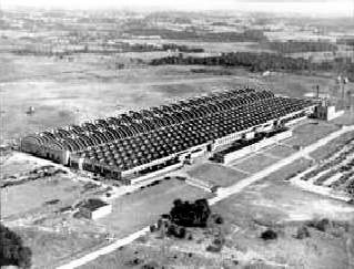
A circa 1940s aerial view looking east at the Budd Red Lion Factory, with one runway visible behind the factory.
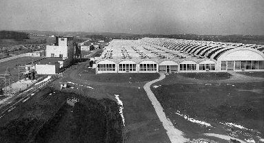
A circa 1940s photo looking northwest at the Budd Red Lion Factory.
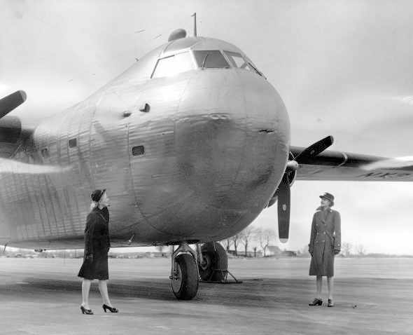
A 1/29/45 view of a Budd RB-1 Conestoga at Budd Field.
Posing with the RB-1 were Sally Siebert from the Women Accepted for Volunteer Emergency Service (WAVE)
and Winifred Thompson from the Women’s Army Corps (WAC).
A total of 14 war-surplus Budd RB-1s eventually became the starting point of Robert Prescott's Flying Tiger Airlines in 1945.
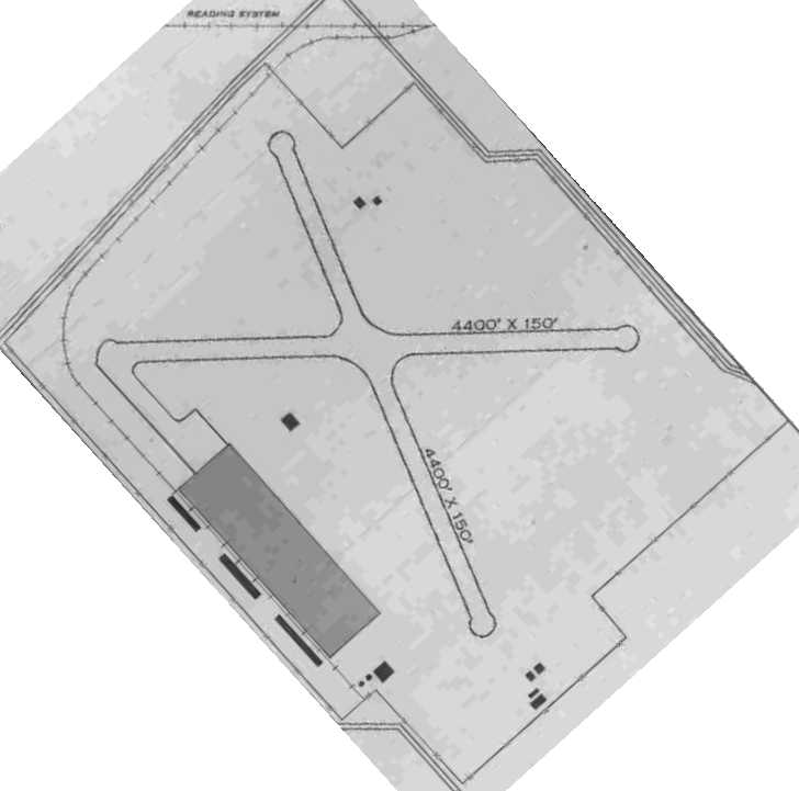
The 1945 AAF Airfield Directory (courtesy of Scott Murdock) described Budd Field
as a 565 acre irregularly-shaped property within which were two 4,400' asphalt runways, oriented east/west & NNW/SSE.
The field was said to have a single concrete 126' x 37' hangar.
Budd Field was described as being owned by the Defense Plant Corporation, but not currently in operation.
A 1946 USGS map depicted the outline of Budd Airfield,
as well as several nearby airports: Somerton Airfield, Boulevard Airfield, and Northeast Philadelphia Airfield.
After WW2, Budd abandoned the manufacturing of aircraft,
and the plant was once again retooled to produce automobile frames & railroad cars.
A 1948 aerial view depicted the Budd Airfield as completely intact.
Runways 9/27 & 16/34 were marked as active,
and “Budd, Tower 317 K.C.” was painted in large letters on the runway intersection.
There were no aircraft visible on the field.
The Red Lion Plant, previously leased from the government, was bought outright by Budd in 1948.
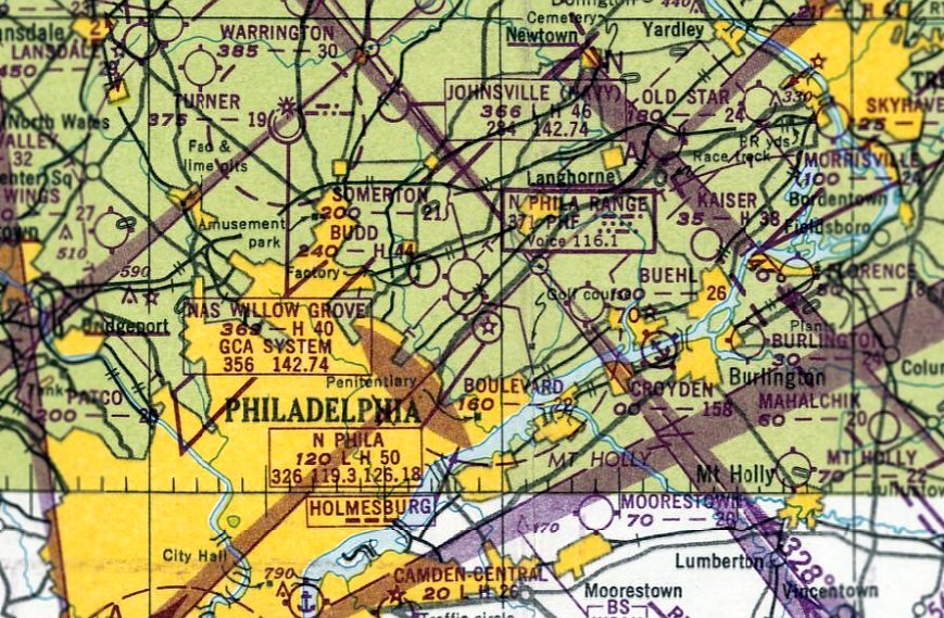
The earliest aeronautical chart depiction of the Budd airfield which has been located was on the January 1949 NY Sectional Chart.
It depicted Budd as having a 4,400' paved runway.
The Budd Airfield was apparently closed at some point in 1949,
as it was no longer depicted on the July 1949 NY Sectional Chart (courtesy of Ron Plante).
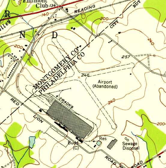
The 1950 USGS topo map depicted 2 unpaved runways, labeled as “Airport (Abandoned)”.
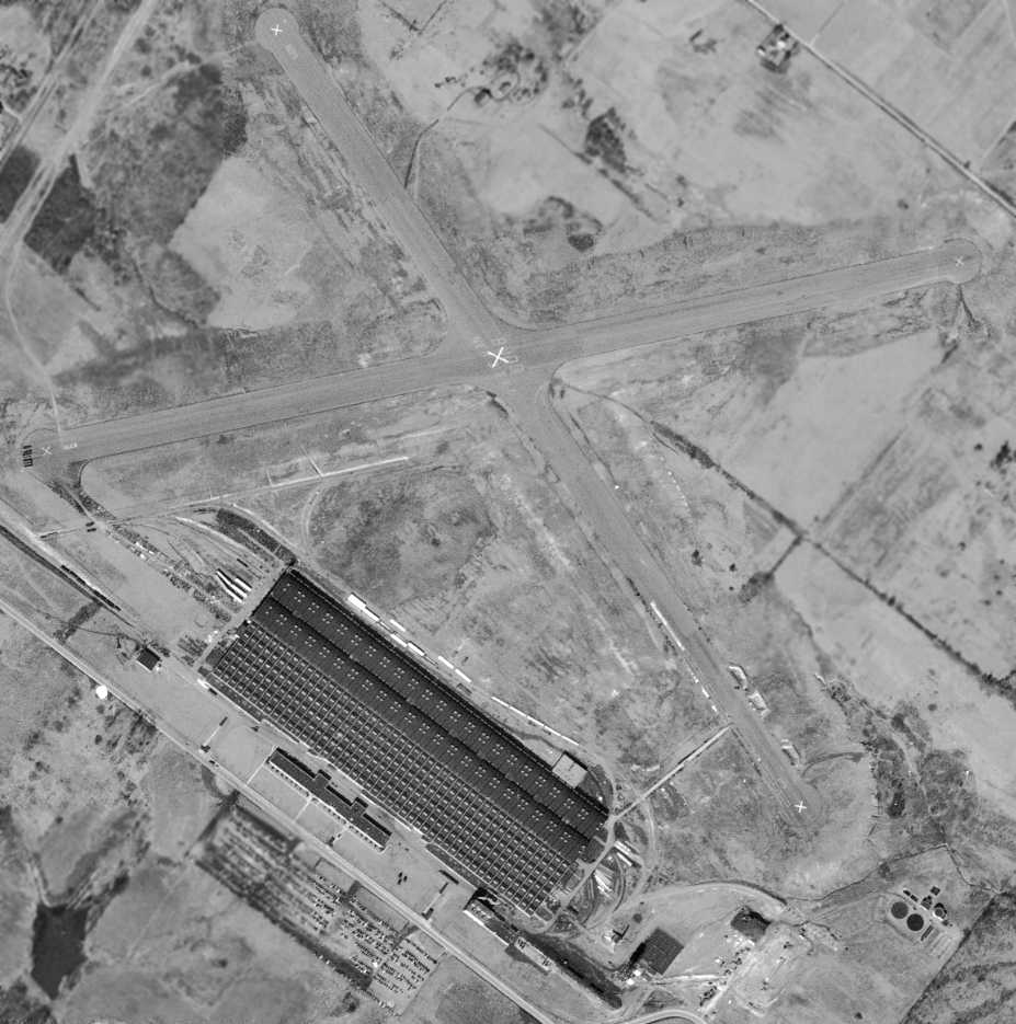
The last photo which has been located showed the Budd Airfield remaining completely intact was a 3/17/50 USGS aerial view.
It showed that closed-runway “X” markings had been added to each runway end at some point between 1948-50,
but the “Budd, Tower 317 K.C.” was still perceptible (but faded) on the runway intersection.
A 1953 aerial view showed that the western & southern halves of the runways were being used to store unidentified objects.
A road had been cut over the southeastern portion of Runway 34 at some point between 1950-53.
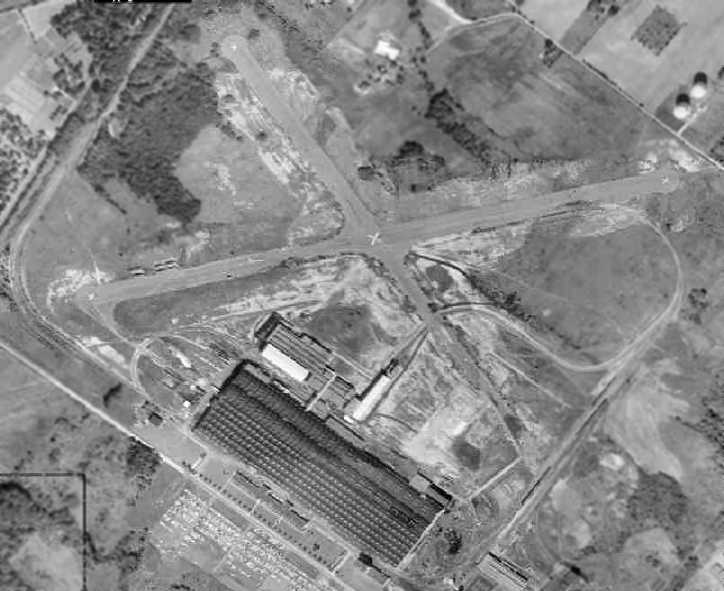
A 1958 aerial photo depicted the Budd Factory Airfield while it was still mostly intact,
with the majority of the length of both paved runways still intact.
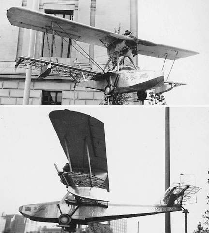
An circa 1950s photo of the Budd BB-1 Pioneer, as it sat mounted on a pylon outside the Franklin Institute (courtesy of Tom Beamer).
Sadly, according to Tom Beamer, the sole example of the Budd Pioneer sat outside on a mounting
in front of Philadelphia's Franklin Institute for a long time.
This eventually led to the loss of the Pioneer's lower wing & empennage fabric, deteriorated by time & weather.
"By the time I saw it in the 1970s both wings were bare."
By the 1960s the former Budd airfield was used to store railcar frames.
A 1965 aerial view showed that residential construction had begun on the northeastern end of Runway 27.
A 1967 aerial view showed that houses covered the northeastern portion of the airfield site.
The runways at the Budd plant were not depicted at all on the 1969 USGS topo map.
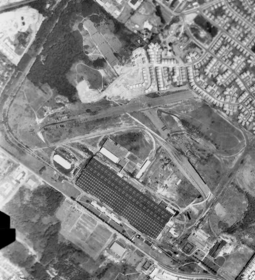
An 8/7/71 aerial photo showed that most of the length of the 2 paved runways of the former Budd Factory Airfield still remained intact,
with the factory & numerous other industrial buildings remaining on the southern side of the property.
Residential construction had started to cover a middle portion of the former northwest/southeast runway.
In the 1980s the plant was sold to TransitAmerica Corporation in an attempt to reverse its declining fortunes.
That attempt was unsuccessful.
In April 1988, the last rail car rolled out of the Budd Red Lion plant,
according to “Living in the Past”, an article by Harry Silcox in the 10/9/08 issue of the Northeast Times.
On the following Friday, the last labor contract covering the workers expired.
The plant soon closed.
The facility sat vacant for several years, as attempts to sell it again met with no takers.
The runways at the Budd plant were not depicted at all on the 1983 or 1988 USGS topo maps.
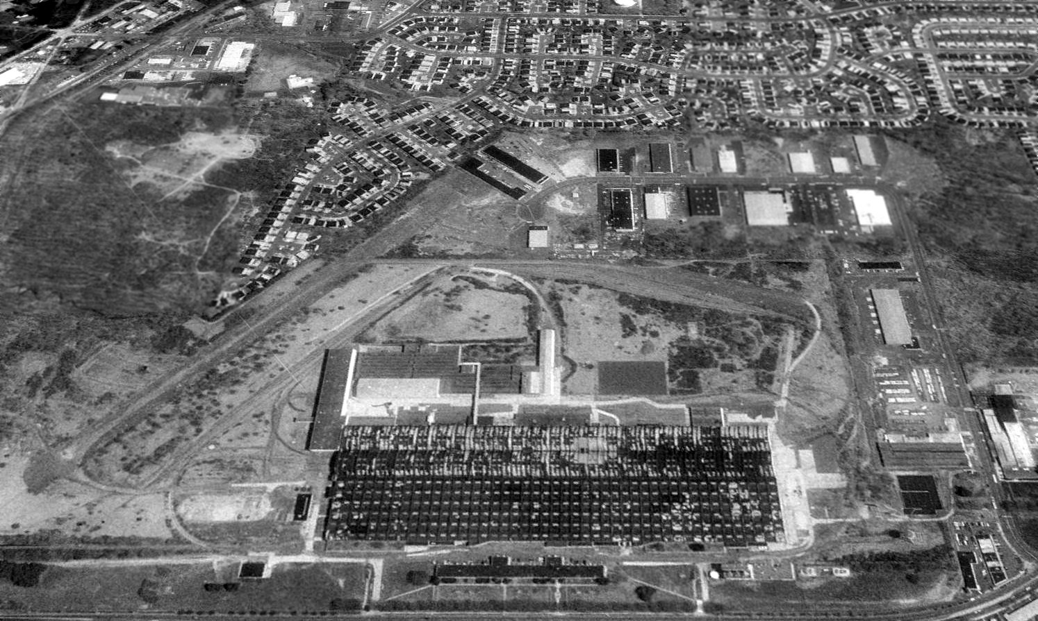
A 1992 USGS aerial view looking northeast showed the Budd factory was still standing,
and most of the East-Northeast/West-Southwest runway was still discernible, as was the southern half of the Northwest/Southeast runway.
Several more recent buildings had been built at some point over the northern half of that runway.
A 1999 aerial view showed the Budd factory & runway remains still intact.
TransitAmerica razed the Budd factory in 1999, and a golf course was constructed on the site.
A 2002 aerial view showed a golf course covering the site of Budd Factory Airfield,
with not a trace remaining of the airplane factory or its airfield.
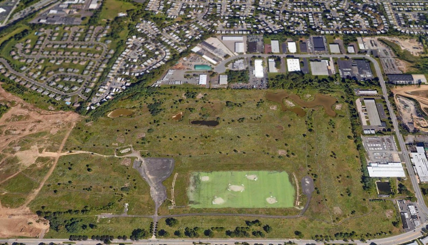
A 2017 aerial view looking northeast showed the golf course on the site of Budd Factory Airfield had evidently been closed,
with the property awaiting yet another redevelopment, presumably for ever more housing.
The Budd Company factory was located north of the intersection of Red Lion Road & Sandmeyer Lane, just 2 miles northeast from Northeast Philadelphia Airport,
directly along the extended centerline of PNE's Runway 33.
Thanks to Jay Cooke for pointing out this field.
...............................................................................................................
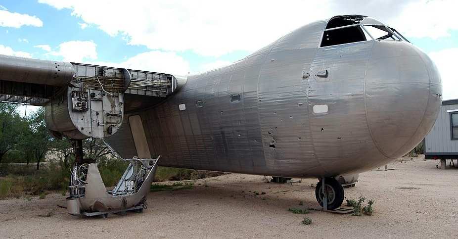
A 2002 photo by AirNikon of the sole remaining example of the Budd RB-1 Conestoga,
which sat unrestored at the Pima Air & Space Museum in Tucson, AZ.
See also: http://www.wplives.com/wp/Operations/Passenger/CZHIST_1/CZEQUI_1/czequi_1.html
____________________________________________________
Or if you prefer to contact me directly concerning a contribution (for a mailing address to send a check),
please contact me at: paulandterryfreeman@gmail.com
If you enjoy this web site, please support it with a financial contribution.
____________________________________________________
This site covers airfields in all 50 states.